|
Jaggayyapet
Jaggayyapeta, also spelled “Jaggaiahpet”, is a census town in NTR district of the Indian state of Andhra Pradesh, located just southwest of the border with Telangana. It is also the mandal headquarters of Jaggayyapeta mandal of Nandigama revenue division. Jaggayyapet is the second biggest town in the district followed by Vijayawada.The town is located on the banks of the Paleru, Paleru River which is a tributary of the Krishna River. Etymology Jaggaiahpeta was governed by a ruler, by name Sri Rajah Vasireddy Venkatadri Nayudu. It is said that he founded two towns, namely, Jaggayyapeta, named after his father Jaggayya, and Atchampet, Andhra Pradesh, Achampeta, named after his mother Atchamma. History Government records suggest the founder of the town was Venkatadri Nayudu, who developed and renamed the village of Betavolu to Jaggayyapeta. The region was then infested with robbers and hence the old village was called Dongala Betavolu (Robbers' Betavolu). For some time, J ... [...More Info...] [...Related Items...] OR: [Wikipedia] [Google] [Baidu] |
Jaggayyapeta Mandal
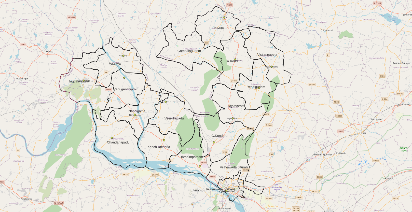
Jaggayyapeta mandal is one of the 20 mandals in NTR district of the state of Andhra Pradesh in India. It is under the administration of List of Revenue Divisions in Andhra Pradesh, Nandigama revenue division and the headquarters are located at Jaggayyapeta town. Krishna River flows through the mandal and is bounded by Penuganchiprolu, Nandigama, Chandarlapadu mandals of Krishna district, part of Guntur district, Nalgonda district, Nalgonda and Khammam districts of Telangana. Towns and villages Census of India, census, the mandal has 18 settlements. It includes 1 town and 24 villages. The settlements in the mandal are listed below: ''Note: (CT)-Census town'' See also *Vijayawada revenue division References Mandals in NTR district {{AndhraPradesh-geo-stub ... [...More Info...] [...Related Items...] OR: [Wikipedia] [Google] [Baidu] |
NTR District
NTR district is a district in coastal Andhra Region in the Indian state of Andhra Pradesh. The district headquarters is located at Vijayawada. The district is named after former Chief Minister of Andhra Pradesh N. T. Rama Rao. The district shares boundaries with Guntur, Palnadu, Krishna, Eluru, Khammam and Suryapet districts. History NTR district was proposed on 26 January 2022 and became one of the twenty-six districts in the state after the gazette notification was issued by the Government of Andhra Pradesh on 3 April 2022. The gazette notification came into force on 4 April 2022. The district was carved out of Krishna district, and consists of the existing Vijayawada revenue division along with Nandigama and Tiruvuru revenue divisions, which were formed along with the district. It was named in the memory of Nandamuri Taraka Rama Rao (NTR), a prominent figure in the history of Andhra Pradesh. NTR, a celebrated actor and politician, was the founder of ... [...More Info...] [...Related Items...] OR: [Wikipedia] [Google] [Baidu] |
Nandigama Revenue Division
Nandigama revenue division is an administrative division in the NTR district of the Indian state of Andhra Pradesh. It is one of the 3 List of revenue divisions in Andhra Pradesh, revenue divisions in the district with 7 mandals under its administration and is formed on 4 April 2022 as part of a reorganisation of districts in the state. Nandigama serves as the headquarters of the division. Administration The mandals in the division are # Jaggayyapeta mandal, Jaggayyapeta # Vatsavai mandal, Vatsavai # Penuganchiprolu mandal, Penuganchiprolu # Nandigama mandal, Nandigama # Chandarlapadu mandal, Chandarlapadu # Kanchikacherla mandal, Kanchikacherla # Veerullapadu mandal, Veerullapadu References Revenue divisions in NTR district {{AndhraPradesh-geo-stub ... [...More Info...] [...Related Items...] OR: [Wikipedia] [Google] [Baidu] |
Paleru
Paleru is a tributary of the Krishna river which joins the main river near Mukteswarapuram in Jaggayyapeta mandal of Krishna district in Andhra Pradesh. During the Nizam rule, a reservoir was constructed on the river at Paleru village, Kusumanchi. Hundreds of acres are irrigated with the help of this reservoir. Paleru reservoir acts as a balancing reservoir to the Nagarjunasagar left canal. Attraction There is a small park adjoining the reservoir where boating facility is available. Bhakta Ramadasu lift irrigation scheme Bhakta Ramadasu Lift Irrigation scheme is under final stages of completion for using 5.5 tmcft Tmcft, (Tmc ft), (TMC), (tmc) is the abbreviation of thousand million cubic feet (1,000,000,000 = 109 = 1 billion), commonly used in India in reference to volume of water in a reservoir or river A river is a natural stream of fresh wa ... water for stabilising water supply to nearly 60,000 acres which was part of SRSP (stage II) irrigation projec ... [...More Info...] [...Related Items...] OR: [Wikipedia] [Google] [Baidu] |
Town
A town is a type of a human settlement, generally larger than a village but smaller than a city. The criteria for distinguishing a town vary globally, often depending on factors such as population size, economic character, administrative status, or historical significance. In some regions, towns are formally defined by legal charters or government designations, while in others, the term is used informally. Towns typically feature centralized services, infrastructure, and governance, such as municipal authorities, and serve as hubs for commerce, education, and cultural activities within their regions. The concept of a town varies culturally and legally. For example, in the United Kingdom, a town may historically derive its status from a market town designation or City status in the United Kingdom, royal charter, while in the United States, the term is often loosely applied to incorporated municipality, municipalities. In some countries, such as Australia and Canada, distinction ... [...More Info...] [...Related Items...] OR: [Wikipedia] [Google] [Baidu] |
Chakravartin
A ''chakravarti'' (, ) is an ideal (or idealized) universal ruler, in the history, and religion of India. The concept is present in Indian subcontinent cultural traditions, narrative myths and lore. There are three types of chakravarti: ''chakravala chakravarti'', an emperor who rules over all four of the continents (i.e., a universal monarch); ''dvipa chakravarti'', a ruler who governs only one of those continents; and ''pradesha chakravarti'', a monarch who leads the people of only a part of a continent, the equivalent of a local king. Dvipa chakravarti is particularly one who rules the entire Indian subcontinent (as in the case of the Mauryan Empire). The first references to a ''Chakravala Chakravartin'' appear in monuments from the time of the early Maurya Empire, in the 4th to 3rd century BCE, in reference to Emperor Ashoka. The word is a bahuvrīhi compound word, translating to "one who move the wheels", in the sense of "whose chariot is rolling everywhere without ... [...More Info...] [...Related Items...] OR: [Wikipedia] [Google] [Baidu] |
Medieval Period
In the history of Europe, the Middle Ages or medieval period lasted approximately from the 5th to the late 15th centuries, similarly to the post-classical period of World history (field), global history. It began with the fall of the Western Roman Empire and transitioned into the Renaissance and the Age of Discovery. The Middle Ages is the middle period of the three traditional divisions of Western history: classical antiquity, the medieval period, and the modern period. The medieval period is itself subdivided into the Early Middle Ages, Early, High Middle Ages, High, and Late Middle Ages. Population decline, counterurbanisation, the collapse of centralised authority, invasions, and mass migrations of tribes, which had begun in late antiquity, continued into the Early Middle Ages. The large-scale movements of the Migration Period, including various Germanic peoples, formed new kingdoms in what remained of the Western Roman Empire. In the 7th century, North Africa and the ... [...More Info...] [...Related Items...] OR: [Wikipedia] [Google] [Baidu] |
Megalithic
A megalith is a large Rock (geology), stone that has been used to construct a prehistoric structure or monument, either alone or together with other stones. More than 35,000 megalithic structures have been identified across Europe, ranging geographically from Sweden in the north to the Mediterranean Sea in the south. The word was first used in 1849 by the British antiquarian Algernon Herbert in reference to Stonehenge and derives from the Ancient Greek words "wikt:μέγας, mega" for great and "wikt:λίθος, lithos" for stone. Most extant megaliths were erected between the Neolithic period (although earlier Mesolithic examples are known) through the Chalcolithic, Chalcolithic period and into the Bronze Age. Types and definitions While "megalith" is often used to describe a single piece of stone, it also can be used to denote one or more rocks hewn in definite shapes for special purposes. It has been used to describe structures built by people from many parts of the wo ... [...More Info...] [...Related Items...] OR: [Wikipedia] [Google] [Baidu] |
Neolithic
The Neolithic or New Stone Age (from Ancient Greek, Greek 'new' and 'stone') is an archaeological period, the final division of the Stone Age in Mesopotamia, Asia, Europe and Africa (c. 10,000 BCE to c. 2,000 BCE). It saw the Neolithic Revolution, a wide-ranging set of developments that appear to have arisen independently in several parts of the world. This "Neolithic package" included the History of agriculture, introduction of farming, domestication of animals, and change from a hunter-gatherer lifestyle to one of sedentism, settlement. The term 'Neolithic' was coined by John Lubbock, 1st Baron Avebury, Sir John Lubbock in 1865 as a refinement of the three-age system. The Neolithic began about 12,000 years ago, when farming appeared in the Epipalaeolithic Near East and Mesopotamia, and later in other parts of the world. It lasted in the Near East until the transitional period of the Chalcolithic (Copper Age) from about 6,500 years ago (4500 BCE), marked by the development ... [...More Info...] [...Related Items...] OR: [Wikipedia] [Google] [Baidu] |
Buddhist Stupa
In Buddhism, a stupa (, ) is a domed hemispherical structure containing several types of sacred relics, including images, statues, metals, and ''śarīra''—the remains of Buddhist monks or nuns. It is used as a place of pilgrimage and meditation. Walking around a stupa in a clockwise direction, known as ''pradakhshina'', has been an important ritual and devotional practice in Buddhism since the earliest times, and stupas always have a ''pradakhshina'' path around them. The original South Asian form is a large solid dome above a tholobate, or drum, with vertical sides, which usually sits on a square base. There is no access to the inside of the structure. In large stupas, there may be walkways for circumambulation on top of the base as well as on the ground below it. Large stupas have, or had, ''vedikā'' railings outside the path around the base, often highly decorated with sculpture, especially at the torana gateways, of which there are usually four. At the top of the dom ... [...More Info...] [...Related Items...] OR: [Wikipedia] [Google] [Baidu] |
Archaeological Excavation
In archaeology, excavation is the exposure, processing and recording of archaeological remains. An excavation site or "dig" is the area being studied. These locations range from one to several areas at a time during a project and can be conducted over a few weeks to several years. Excavation involves the recovery of several types of data from a site. This data includes Artifact (archaeology), artifacts (portable objects made or modified by humans), Feature (archaeology), features (non-portable modifications to the site itself such as post molds, burials, and hearths), Ecofact, ecofacts (evidence of human activity through organic remains such as animal bones, pollen, or charcoal), and archaeological context (relationships among the other types of data).Kelly&Thomas (2011). ''Archaeology: down to earth'' (4th ed.). Belmont, Calif.: Wadsworth, Cengage Learning. Before excavating, the presence or absence of archaeological remains can often be suggested by, non-intrusive remote se ... [...More Info...] [...Related Items...] OR: [Wikipedia] [Google] [Baidu] |


