|
Jabllanica
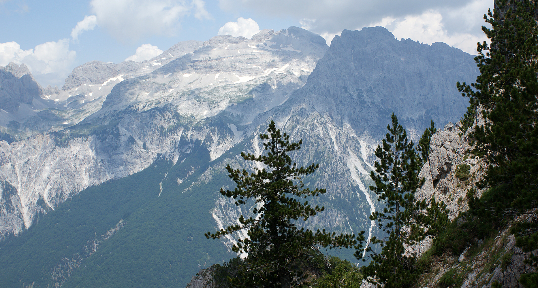
Jablanica ( ; ) is a mountain range stretching between the state borders of Albania and North Macedonia. The larger section of the range is located within Albania, where it forms part of the Shebenik National Park, bounded by the municipalities of Librazhd to the southeast and Dibër to the northwest. On the North Macedonia side, it lies within the limits of Struga municipality. Its highest peak, ''Black Rock'' (; ), reaches a height of , marking the delineation point for both countries. Geology Composed primarily of Triassic-Jurassic limestones, the range features a complex anticlinal structure with tectonic detachments. It resembles a large elevated horst surrounded by tectonic-erosive slopes, the most prominent of which are found on the western and eastern edges, near Rrethi i Kurorës and Rajcë, respectively. As the mountain range descends southeastward, it becomes less elevated due to subsidence in the Ohrid graben. The northwestern section of the range is rugged and ... [...More Info...] [...Related Items...] OR: [Wikipedia] [Google] [Baidu] |
Shebenik National Park
Shebenik National Park () is a national park in eastern Albania adjacent to the border with North Macedonia. It encompasses and is specifically marked by a mountainous landscape supplied with glacial lakes, valleys, dense coniferous and deciduous forests and alpine meadows and pastures. Elevations in the park vary from 300 metres to over 2,200 metres above the Adriatic at the peak of Shebenik and Jabllanica, hence the name. It dwells a number of endangered species that are fast becoming rare in Southern Europe, including the brown bear, gray wolf and Balkan lynx. The abundance in wildlife can in part be explained by the variety of vegetation types and remote location. The park offers some of the most rugged scenery in the eastern section of country that were carved into their present shapes by the glaciers of the last ice age. It is home to 14 glacial lakes, the highest situated between 1,500 and 1,900 metres elevation above the Adriatic.Protection and Preservation of Natural ... [...More Info...] [...Related Items...] OR: [Wikipedia] [Google] [Baidu] |
List Of Mountains In Albania
Albania is mostly mountainous, with the first alpine regions forming towards the end of the Jurassic period. During the Cenozoic era, the malformation of the ''Albanides'' accelerated, causing the subterranean landscape to take its present form. The average altitude of the country is , almost three times that of Europe. Its highest summits are situated in the Albanian Alps and the eastern mountain range, with Korab being the highest peak, at above sea level. The country's geography is unique due to its location and varied relief, with landscapes ranging from mediterranean in the west to a more continental influence in the east and mountainous terrain in the interior and east. This combination of plains, hills and mountains has resulted in a diverse range of geographical features, extending horizontally and vertically. However, this complexity has made regionalization challenging, as different authors have used alternating criteria and methods. In the 1920s, Herbert Louis propo ... [...More Info...] [...Related Items...] OR: [Wikipedia] [Google] [Baidu] |
Mountains Of Albania
Albania is mostly mountainous, with the first alpine regions forming towards the end of the Jurassic, Jurassic period. During the Cenozoic, Cenozoic era, the malformation of the ''Albanides'' accelerated, causing the subterranean landscape to take its present form. The average altitude of the country is , almost three times that of Europe. Its highest summits are situated in the Accursed Mountains, Albanian Alps and the eastern mountain range, with Korab (mountain), Korab being the highest peak, at above sea level. The country's geography is unique due to its location and varied relief, with landscapes ranging from Mediterranean Basin, mediterranean in the west to a more Geographical midpoint of Europe, continental influence in the east and mountainous terrain in the interior and east. This combination of plains, hills and mountains has resulted in a diverse range of geographical features, extending horizontally and vertically. However, this complexity has made regionalization ch ... [...More Info...] [...Related Items...] OR: [Wikipedia] [Google] [Baidu] |
Central Mountain Region (Albania)
The Central Mountain Region () is a physiogeographical region encompassing the central and eastern edge of Albania. It comprises the mountainous inland extending all the way from the valley of Drin Valley, Drin and the mountains of Sharr Mountain, Sharr, Skanderbeg Mountains, Skanderbeg, Korab, and Shebenik-Jablanica (mountain range), Jabllanicë, through the lakes of Lake of Ohrid, Ohrid and Prespa Lake, Prespa, until it reaches the village of Ersekë and the mountains of Pindus Mountains, Pindus close to the border between the country and Greece. The central mountain range can be conventionally divided into a number of subregions. The north encompasses the mountainous districts of Mirditë District, Mirditë and Pukë District, Pukë. The center is dominated by the mountains of Kunora e Lurës, Lurë and Korab alongside the regions of Martanesh and Çermenikë. The south includes the valley of Shkumbin as well as the mountains of Mokër and Valamara, the plain of Korçë Plain, ... [...More Info...] [...Related Items...] OR: [Wikipedia] [Google] [Baidu] |
Karst
Karst () is a topography formed from the dissolution of soluble carbonate rocks such as limestone and Dolomite (rock), dolomite. It is characterized by features like poljes above and drainage systems with sinkholes and caves underground. There is some evidence that karst may occur in more weathering-resistant rocks such as quartzite given the right conditions. Subterranean drainage may limit surface water, with few to no rivers or lakes. In regions where the dissolved bedrock is covered (perhaps by debris) or confined by one or more superimposed non-soluble rock strata, distinctive karst features may occur only at subsurface levels and can be totally missing above ground. The study of ''paleokarst'' (buried karst in the stratigraphic column) is important in petroleum geology because as much as 50% of the world's Oil and gas reserves and resource quantification, hydrocarbon reserves are hosted in carbonate rock, and much of this is found in porous karst systems. Etymology ... [...More Info...] [...Related Items...] OR: [Wikipedia] [Google] [Baidu] |
Two-thousanders Of North Macedonia
Two-thousanders are mountains that have a height of at least 2,000 height above sea level, metres above sea level, but less than 3,000 metres. The term is used in Alpine circles, especially in Europe (e.g. German: ''Zweitausender''). The two photographs show two typical two-thousanders in the Alps that illustrate different types of mountain. The Säuling (top) is a prominent, individual peak, whereas the Schneeberg (bottom) is an elongated limestone massif. In ranges like the Allgäu Alps, the Gesäuse or the Styrian-Lower Austrian Limestone Alps the mountaineering, mountain tour descriptions for mountaineers or hikers commonly include the two-thousanders, especially in areas where only a few summits exceed this level. Examples from these regions of the Eastern Alps are: * the striking Nebelhorn (mountain), Nebelhorn (2,224 m) near Oberstdorf or the Säuling (2,047 m) near Neuschwanstein, * the Admonter Reichenstein (2,251 m), Eisenerzer Reichenstein (2,165&nb ... [...More Info...] [...Related Items...] OR: [Wikipedia] [Google] [Baidu] |
Two-thousanders Of Albania
Two-thousanders are mountains that have a height of at least 2,000 metres above sea level, but less than 3,000 metres. The term is used in Alpine circles, especially in Europe (e.g. German: ''Zweitausender''). The two photographs show two typical two-thousanders in the Alps that illustrate different types of mountain. The Säuling (top) is a prominent, individual peak, whereas the Schneeberg (bottom) is an elongated limestone massif. In ranges like the Allgäu Alps, the Gesäuse or the Styrian-Lower Austrian Limestone Alps the mountain tour descriptions for mountaineers or hikers commonly include the two-thousanders, especially in areas where only a few summits exceed this level. Examples from these regions of the Eastern Alps are: * the striking Nebelhorn (2,224 m) near Oberstdorf or the Säuling (2,047 m) near Neuschwanstein, * the Admonter Reichenstein (2,251 m), Eisenerzer Reichenstein (2,165 m), Großer Pyhrgas (2,244 m) or Hochtor (2, ... [...More Info...] [...Related Items...] OR: [Wikipedia] [Google] [Baidu] |
Mountain Ranges Of Albania
A mountain is an elevated portion of the Earth's crust, generally with steep sides that show significant exposed bedrock. Although definitions vary, a mountain may differ from a plateau in having a limited summit area, and is usually higher than a hill, typically rising at least above the surrounding land. A few mountains are isolated summits, but most occur in mountain ranges. Mountains are formed through tectonic forces, erosion, or volcanism, which act on time scales of up to tens of millions of years. Once mountain building ceases, mountains are slowly leveled through the action of weathering, through slumping and other forms of mass wasting, as well as through erosion by rivers and glaciers. High elevations on mountains produce colder climates than at sea level at similar latitude. These colder climates strongly affect the ecosystems of mountains: different elevations have different plants and animals. Because of the less hospitable terrain and climate, mountains t ... [...More Info...] [...Related Items...] OR: [Wikipedia] [Google] [Baidu] |
List Of Mountains In North Macedonia
The following is a list of mountains in North Macedonia. North Macedonia is a predominantly mountainous country. The average elevation of the terrain is 850 meters. Approximately 80% of the country consists of hills and mountains. The mountains are divided into two basic groups: on the one hand in the North-West the Šar Mountains mountain range that continues to the ''West Vardar/Pelagonia mountain range'' in the South-West and South (contiguous with the Dinaric ranges). On the other hand, in the South-East the Osogovo- Belasica mountain chain (westernmost section of the Rila- Rhodope Mountains). The Šar Mountains and ''West Vardar/Pelagonia'' mountain range is a continuation between the Dinaric Alps to the north and Pindus mountain ranges to the south, whereas the Osogovo- Belasica mountain chain is a continuation of the Rila- Rhodopes mountain massif. ''Šar mountain'' range: * Šar Mountains * Mount Korab * Mount Bistra * Stogovo * Dešat * Jablanica * Galičic ... [...More Info...] [...Related Items...] OR: [Wikipedia] [Google] [Baidu] |
Eurasian Lynx
The Eurasian lynx (''Lynx lynx'') is one of the four wikt:extant, extant species within the medium-sized wild Felidae, cat genus ''Lynx''. It is widely distributed from Northern Europe, Northern, Central Europe, Central and Eastern Europe to Central Asia and Siberia, the Tibetan Plateau and the Himalayas. It inhabits Temperate forest, temperate and boreal forests up to an elevation of . Despite its wide distribution, it is threatened by habitat loss and habitat fragmentation, fragmentation, poaching and depletion of prey. Taxonomy ''Felis lynx'' was the scientific name used in 1758 by Carl Linnaeus in his work ''Systema Naturae''. In the 19th and 20th centuries, the following Eurasian lynx subspecies were proposed: The following were also proposed, but are not considered Valid name (zoology), valid taxa: *Altai lynx (''L. l. wardi'') *Baikal lynx (''L. l. kozlovi'') *Amur lynx (''L. l. stroganovi'') *Sardinian lynx (''L. l. sardiniae'') Characteristics The Eurasian lyn ... [...More Info...] [...Related Items...] OR: [Wikipedia] [Google] [Baidu] |
Balkan Lynx
The Balkan lynx (''Lynx lynx balcanicus'') is a subspecies of the Eurasian lynx in the genus ''Lynx''. It is found in Bosnia, Albania, Kosovo and western North Macedonia, with smaller populations in Montenegro. It is considered a national symbol in North Macedonia and appears on the 5- denar coin. It is believed that in North Macedonia there are from 35 to 40 remaining Balkan lynx, mostly found in Mavrovo National Park. This cat is considered to be the largest cat in the Balkans. It has been sighted in 2011 and 2012 in the northern mountainous region of Albania and within the boundaries of the Shebenik-Jabllanice National Park. The lynx is classified as Critically Endangered in Albania and has been protected de jure since 1969 but, despite this, poaching and habitat destruction threatens the remaining Balkan lynx populations in both Albania and North Macedonia. There are an estimated 15-20 individuals still alive in Albania. The Balkan lynx has been on the brink of extinction ... [...More Info...] [...Related Items...] OR: [Wikipedia] [Google] [Baidu] |


