|
Isla Mujeres Municipality
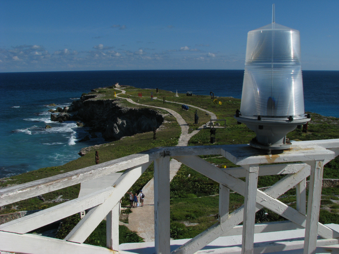
Isla Mujeres (, Spanish for ''Island of the Women'') is one of the eleven municipalities of the Mexican state of Quintana Roo, located on the Yucatán Peninsula. Most of the municipality is located on the mainland in the northeastern corner of the state. Its municipal seat, also called Isla Mujeres, is a small town on the island from which it takes its name. It is located about northeast of Cancún in the Caribbean Sea The Caribbean Sea is a sea of the Atlantic Ocean, North Atlantic Ocean in the tropics of the Western Hemisphere, located south of the Gulf of Mexico and southwest of the Sargasso Sea. It is bounded by the Greater Antilles to the north from Cuba ..., and it is the easternmost municipal seat in Mexico. As of the census, the town had a population of inhabitants.2010 census tables: INEGI ...
|
Municipalities Of Mexico
Municipalities () are the administrative divisions under the List of states of Mexico, states of Mexico according to the Constitution of Mexico, constitution. Municipalities are considered as the second-level administrative divisions by the Federal government of Mexico, federal government. However, some state regulations have designed intrastate regions to administer their own municipalities. Municipalities are further divided into Localities of Mexico, localities in the structural hierarchy of administrative divisions of Mexico. As of December 2024, there are 2,462 municipalities in Mexico. In Mexico, municipalities should not be confused with cities (). Cities are Localities of Mexico, locality-level divisions that are administered by the municipality. Although some List of cities in Mexico, larger cities are consolidated with its own municipality and form a single level of governance. In addition, the 16 Boroughs of Mexico City, boroughs of Mexico City are considered municipali ... [...More Info...] [...Related Items...] OR: [Wikipedia] [Google] [Baidu] |
States Of Mexico
A Mexican State (), officially the Free and Sovereign State (), is a constituent Federated state, federative Polity, entity of Mexico according to the Constitution of Mexico. Currently there are 31 states, each with its own constitution, State governments of Mexico, government, Lists of Mexican state governors, state governor, and List of Mexican state congresses, state congress. In the hierarchy of Administrative divisions of Mexico, Mexican administrative divisions, states are further divided into municipalities of Mexico, municipalities. Currently there are 2,462 municipalities in Mexico. Although not formally a state, political reforms have enabled Mexico City (), the capital city of the Mexico, United Mexican States to have a federative entity status equivalent to that of the states since January 29, 2016. Current Mexican governmental publications usually lists 32 federative entities (31 states and Mexico City), and 2,478 municipalities (including the 16 boroughs of Mexico ... [...More Info...] [...Related Items...] OR: [Wikipedia] [Google] [Baidu] |
Isla Mujeres
Isla Mujeres (, Spanish for "Women Island", formally “''Isla de Mujeres''”) is an island where the Gulf of Mexico and the Caribbean Sea meet, about off the Yucatán Peninsula coast in the State of Quintana Roo, Mexico. It is approximately long and wide. To the east is the Caribbean Sea with a strong surf and rocky coast, and to the west the skyline of Cancún can be seen across the waters. In the 2010 census, the namesake town on the island had a population of 12,642 inhabitants. The town is the seat of Isla Mujeres Municipality. History In Pre-Columbian times, the island was sacred to the Maya goddess of childbirth and medicine, Ixchel. When the Spanish arrived in the 16th century they named it "''Isla Mujeres''" after the many images of goddesses. The first information available about Isla Mujeres is from between 564–1516 AD, when it was part of the Maya province called Ekab. There were four Maya provinces in the area of the modern state of Quintana Roo. The M ... [...More Info...] [...Related Items...] OR: [Wikipedia] [Google] [Baidu] |
Quintana Roo
Quintana Roo, officially the Free and Sovereign State of Quintana Roo, is one of the 31 states which, along with Mexico City, constitute the 32 administrative divisions of Mexico, federal entities of Mexico. It is divided into municipalities of Quintana Roo, 11 municipalities, and its capital city is Chetumal. Quintana Roo is located on the eastern part of the Yucatán Peninsula and is bordered by the states of Campeche to the west and Yucatán (state), Yucatán to the northwest, and by the Orange Walk District, Orange Walk and Corozal District, Corozal districts of Belize, along with an offshore borderline with Belize District to the south. As Mexico's easternmost state, Quintana Roo has a coastline to the east with the Caribbean Sea and to the north with the Gulf of Mexico. The state previously covered and shared a small border with Guatemala in the southwest of the state. However, in 2013, Mexico's Supreme Court of Justice of the Nation resolved the boundary dispute between ... [...More Info...] [...Related Items...] OR: [Wikipedia] [Google] [Baidu] |
INEGI
The National Institute of Statistics and Geography (INEGI from its former name in ) is an autonomous agency of the Government of Mexico, Mexican Government dedicated to coordinate the National System of Statistical and Geographical Information of the country. It was created on January 25, 1983, by presidential decree of Miguel de la Madrid. It is the institution responsible for conducting the Censo General de Población y Vivienda every ten years; as well as the Censo Económico, economic census every five years and the agricultural, livestock and forestry census of the country. The job of gathering statistical information of the Institute includes the monthly gross domestic product, consumer trust surveys and proportion of commercial samples; employment and occupation statistics, domestic and couple violence; as well as many other jobs that are the basis of studies and projections to other governmental institutions. The Institute headquarters are in the Aguascalientes, Aguasc ... [...More Info...] [...Related Items...] OR: [Wikipedia] [Google] [Baidu] |
Spanish Language
Spanish () or Castilian () is a Romance languages, Romance language of the Indo-European languages, Indo-European language family that evolved from the Vulgar Latin spoken on the Iberian Peninsula of Europe. Today, it is a world language, global language with 483 million native speakers, mainly in the Americas and Spain, and about 558 million speakers total, including second-language speakers. Spanish is the official language of List of countries where Spanish is an official language, 20 countries, as well as one of the Official languages of the United Nations, six official languages of the United Nations. Spanish is the world's list of languages by number of native speakers, second-most spoken native language after Mandarin Chinese; the world's list of languages by total number of speakers, fourth-most spoken language overall after English language, English, Mandarin Chinese, and Hindustani language, Hindustani (Hindi-Urdu); and the world's most widely spoken Romance language ... [...More Info...] [...Related Items...] OR: [Wikipedia] [Google] [Baidu] |
Municipalities Of Quintana Roo
A municipality is usually a single administrative division having corporate status and powers of self-government or jurisdiction as granted by national and regional laws to which it is subordinate. The term ''municipality'' may also mean the governing body of a given municipality. A municipality is a general-purpose administrative subdivision, as opposed to a special-purpose district. The English word is derived from French , which in turn derives from the Latin , based on the word for social contract (), referring originally to the Latin communities that supplied Rome with troops in exchange for their own incorporation into the Roman state (granting Roman citizenship to the inhabitants) while permitting the communities to retain their own local governments (a limited autonomy). A municipality can be any political jurisdiction, from a sovereign state such as the Principality of Monaco, to a small village such as West Hampton Dunes, New York. The territory over which a munici ... [...More Info...] [...Related Items...] OR: [Wikipedia] [Google] [Baidu] |
List Of States Of Mexico
A Mexican State (), officially the Free and Sovereign State (), is a constituent federative entity of Mexico according to the Constitution of Mexico. Currently there are 31 states, each with its own constitution, government, state governor, and state congress. In the hierarchy of Mexican administrative divisions, states are further divided into municipalities. Currently there are 2,462 municipalities in Mexico. Although not formally a state, political reforms have enabled Mexico City (), the capital city of the United Mexican States to have a federative entity status equivalent to that of the states since January 29, 2016. Current Mexican governmental publications usually lists 32 federative entities (31 states and Mexico City), and 2,478 municipalities (including the 16 boroughs of Mexico City). Third or lower level divisions are sometimes listed by some governmental publications. List of federative entities Mexico City, though not formally a state, is included for com ... [...More Info...] [...Related Items...] OR: [Wikipedia] [Google] [Baidu] |
Yucatán Peninsula
The Yucatán Peninsula ( , ; ) is a large peninsula in southeast Mexico and adjacent portions of Belize and Guatemala. The peninsula extends towards the northeast, separating the Gulf of Mexico to the north and west of the peninsula from the Caribbean Sea to the east. The Yucatán Channel, between the northeastern corner of the peninsula and Cuba, connects the two bodies of water. The peninsula is approximately in area. It has low relief and is almost entirely composed of porous limestone. The peninsula lies east of the Isthmus of Tehuantepec, the narrowest point in Mexico separating the Atlantic Ocean, including the Gulf of Mexico and Caribbean Sea, from the Pacific Ocean. Some consider the isthmus to be the geography, geographic boundary between Central America and the rest of North America, placing the peninsula in Central America. Politically, all of Mexico, including the Yucatán, is generally considered part of North America, while Guatemala and Belize are considered pa ... [...More Info...] [...Related Items...] OR: [Wikipedia] [Google] [Baidu] |
Cancún
Cancún is the most populous city in the Mexican state of Quintana Roo, located in southeast Mexico on the northeast coast of the Yucatán Peninsula. It is a significant tourist destination in Mexico and the seat of the municipality of Benito Juárez Municipality, Quintana Roo, Benito Juárez. The city is situated on the Caribbean Sea and is one of Mexico's easternmost points. Cancún is located just north of Mexico's Caribbean coast resort area known as the Riviera Maya. Etymology and coat of arms According to early Spanish sources, the island of Cancún was originally known to its Maya peoples, Maya inhabitants as (), meaning either 'Wiktionary:promontory, promontory' or 'point of grass'. The name ''Cancún'', ''Cancum'' or ''Cankun'' first appears on 18th-century maps. In older English-language documents, the city's name is sometimes spelled ''Cancoon'', an attempt to convey the sound of the name. ''Cancún'' is derived from the Mayan name , composed of 'snake' and the v ... [...More Info...] [...Related Items...] OR: [Wikipedia] [Google] [Baidu] |


