|
Inverbervie
Inverbervie (), also known simply as Bervie, is a small town on the north-east coast of Scotland, south of Stonehaven, in the Kincardineshire, Mearns. Etymology The name comes from Scottish Gaelic, Gaelic and means "mouth of Bervie Water". Historical forms, such as ''Haberberui'', recorded in 1290, show that the Gaelic element ''inbhir'', meaning "river mouth", has succeeded the original Common Brittonic, Brittonic element ''aber'', with the same meaning (cf. Welsh language, Welsh ''aber''). History Inverbervie appears in recorded history, written history at least as far back as the 12th century AD; in a document relating to Arbroath Abbey, Simon of Inverbervie is noted as having witnessed a charter transferring the lands of Balfeith to the Abbey. The settlement was formerly a royal burgh from 1342 to 1975 and a parliamentary burgh from 1708 to 1950, the former status being conferred by David II of Scotland for hospitality he and his Queen received when shipwrecked there the ... [...More Info...] [...Related Items...] OR: [Wikipedia] [Google] [Baidu] |
Inverbervie Town House
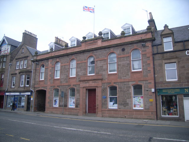
Inverbervie Town House is a municipal structure in Church Street in Inverbervie, Aberdeenshire, Scotland. The structure, which is primarily used as a public library, is a Category B listed building. History The first municipal building in the town was a tolbooth which was erected in the Market Place in 1569. After the tolbooth became dilapidated, it was demolished, and a new town house was erected in Church Street: it was built in the Architecture of Scotland in the Middle Ages, Scottish medieval style using rubble masonry and was completed in 1720. The date stone from the old tolbooth was recovered and inserted into the wall of the new building. On the ground floor there was a market hall and, adjacent to it, a Vault (architecture), vaulted cell which was used for the incarnation of petty criminals. On the first floor, there was an assembly hall and a small council chamber for the burgh council and, at roof level, there was an ornate Belfry (architecture), belfry. By the early ... [...More Info...] [...Related Items...] OR: [Wikipedia] [Google] [Baidu] |
Kincardineshire
Kincardineshire or the County of Kincardine, also known as the Mearns (from the Scottish Gaelic meaning "the stewartry"), is a Shires of Scotland, historic county, registration county and lieutenancy areas of Scotland, lieutenancy area on the coast of north-east Scotland. It is bounded by Aberdeenshire (historic), Aberdeenshire on the north, and by Angus, Scotland, Angus on the south-west. The county was named after its original county town of Kincardine, Aberdeenshire, Kincardine, near Fettercairn. The county town was moved to Stonehaven in 1600, by which time the town of Kincardine was in decline; it was subsequently abandoned. Other towns in the county include Banchory, Inverbervie and Laurencekirk. The county was abolished as an administrative area in 1975. Since 1996, most of the pre-1975 county has formed part of the Aberdeenshire council areas of Scotland, council area, with the exception of Nigg, Aberdeen, Nigg, which is in Aberdeen City. The name "Kincardine" is used ... [...More Info...] [...Related Items...] OR: [Wikipedia] [Google] [Baidu] |
Aberdeen Burghs (UK Parliament Constituency)
Aberdeen Burghs was a district of burghs United Kingdom constituencies, constituency which was represented from 1708 to 1800 in the House of Commons of Great Britain, House of Commons of the Parliament of Great Britain, and from 1801 to 1832 in the House of Commons of the United Kingdom, House of Commons of the Parliament of the United Kingdom. Creation The British parliamentary constituency was created in 1708 following the Acts of Union 1707 and replaced the former Parliament of Scotland burgh constituencies of Aberdeen (Parliament of Scotland constituency), Aberdeen, Arbroath (Parliament of Scotland constituency), Arbroath, Brechin (Parliament of Scotland constituency), Brechin, Inverbervie (Burgh), Inverbervie and Montrose (Parliament of Scotland constituency), Montrose. Boundaries The constituency consisted of the Aberdeen, burgh of Aberdeen in the Aberdeenshire (historic), County of Aberdeen, the Inverbervie, burgh of Inverbervie in the Kincardineshire, County of Kincardi ... [...More Info...] [...Related Items...] OR: [Wikipedia] [Google] [Baidu] |
Montrose Burghs (UK Parliament Constituency)
Montrose Burghs was a district of burghs constituency represented in the House of Commons of the United Kingdom, House of Commons of the Parliament of the United Kingdom from 1832 until 1950. The constituency elected one Member of Parliament (United Kingdom), Member of Parliament (MP) to represent the parliamentary burghs of Montrose, Angus, Montrose, Arbroath, Brechin, Forfar and Inverbervie. In 1950, Montrose, Brechin and Inverbervie were merged into North Angus and Mearns (UK Parliament constituency), North Angus and Mearns, and Arbroath and Forfar were merged into South Angus (UK Parliament constituency), South Angus. Members of Parliament Elections Elections in the 1830s Elections in the 1840s Chalmers resigned by accepting the office of List of Stewards of the Manor of Northstead, Steward of the Manor of Northstead, causing a by-election. Elections in the 1850s Hume's death caused a by-election. ... [...More Info...] [...Related Items...] OR: [Wikipedia] [Google] [Baidu] |
Stonehaven
Stonehaven ( ) is a town on the northeast coast of Scotland, south of Aberdeen. It had a population of 11,177 at th2022 Census Stonehaven was formerly the county town of Kincardineshire, succeeding the now abandoned town of Kincardine, Aberdeenshire, Kincardine. It is currently administered as part of Aberdeenshire. The town is known in the local Doric Scots, Doric dialect as ''Steenhive'' () and is nicknamed ''Stoney''. Pre-history and archaeology Stonehaven is the site of prehistoric events evidenced by finds at Fetteresso Castle and Neolithic pottery excavations from the Spurryhillock area. In 2004, archaeological work by CFA Archaeology, in advance of the building of the Aberdeen to Lochside Natural Gas Pipeline, found two short Cist, cists burials containing cremated remains to the southwest of Stonehaven. Radiocarbon dating put the burials in the first half of the 2nd millennium BC, which was the Early Bronze Age in Scotland. The burials contained stone tool artifacts ... [...More Info...] [...Related Items...] OR: [Wikipedia] [Google] [Baidu] |
Bervie Water
Bervie Water () is a river in Aberdeenshire, Scotland which rises in the Drumtochty Forest and flows across The Mearns to reach the North Sea at Inverbervie. Approximately two kilometres upstream of the North Sea, the Bervie Water flows through the grounds of Allardice Castle. The Bothenoth Burn (Burn of Healing) joins the Bervie Water to the east of Arbuthnott House. At Arbuthnott the river forms a steep-sided valley where gardens were laid out on the south-facing slope. It is a series of four terraces across which run diagonal intersecting grass paths. See also *Carron Water, Aberdeenshire The Carron Water is a river in Kincardineshire, Scotland. Geography The Carron Water rises in Fetteresso Forest on the eastern edge of the Grampian Mountains (Scotland), Grampians. It flows past Fetteresso Castle and discharges into the North ... Rivers of Aberdeenshire {{Scotland-river-stub ... [...More Info...] [...Related Items...] OR: [Wikipedia] [Google] [Baidu] |
Royal Burgh
A royal burgh ( ) was a type of Scottish burgh which had been founded by, or subsequently granted, a royal charter. Although abolished by law in 1975, the term is still used by many former royal burghs. Most royal burghs were either created by Scottish monarchy, the Crown, or upgraded from another status, such as burgh of barony. As discrete classes of burgh emerged, the royal burghs—originally distinctive because they were on royal lands—acquired a monopoly of foreign trade. An important document for each burgh was its burgh charter, creating the burgh or confirming the rights of the burgh as laid down (perhaps orally) by a previous monarch. Each royal burgh (with the exception of four 'inactive burghs') was represented in the Parliament of Scotland and could appoint bailies with wide powers in civil and criminal justice.George S Pryde, ''The Burghs of Scotland: A Critical List'', Oxford, 1965. The four inactive burghs were Auchtermuchty, Earlsferry, Falkland and Newburgh ... [...More Info...] [...Related Items...] OR: [Wikipedia] [Google] [Baidu] |
David II Of Scotland
David II (5 March 1324 – 22 February 1371) was King of Scotland from 1329 until his death in 1371. Upon the death of his father, Robert the Bruce, David succeeded to the throne at the age of five and was crowned at Scone in November 1331, becoming the first Scottish monarch to be anointed at his coronation. During his childhood, David was governed by a series of guardians, and Edward III of England sought to take advantage of David's minority by supporting an invasion of Scotland by Edward Balliol, beginning the Second War of Scottish Independence. Following the English victory at the Battle of Halidon Hill in 1333, King David, Queen Joan and the rump of his government were evacuated to France, where he remained in exile until it was safe for him to return to Scotland in 1341. In 1346, David invaded England in support of France during the Hundred Years' War. His army was defeated at the Battle of Neville's Cross and he was captured and held as a prisoner in England for ... [...More Info...] [...Related Items...] OR: [Wikipedia] [Google] [Baidu] |
Aberdeenshire
Aberdeenshire (; ) is one of the 32 Subdivisions of Scotland#council areas of Scotland, council areas of Scotland. It takes its name from the Shires of Scotland, historic county of Aberdeenshire (historic), Aberdeenshire, which had substantially different boundaries. The Aberdeenshire Council area includes all of the areas of the historic counties of Aberdeenshire and Kincardineshire except the area making up Aberdeen City Council area, as well as part of Banffshire. The historic county boundaries are still officially used for a few purposes, namely land registration and Lieutenancy areas of Scotland, lieutenancy. Aberdeenshire Council is headquartered at Woodhill House in Aberdeen, making it the only Scottish council whose headquarters are located outside its jurisdiction. Aberdeen itself forms a different council area (Aberdeen City). Aberdeenshire borders onto Angus, Scotland, Angus and Perth and Kinross to the south, Highland (council area), Highland and Moray to the west a ... [...More Info...] [...Related Items...] OR: [Wikipedia] [Google] [Baidu] |
Met Office
The Met Office, until November 2000 officially the Meteorological Office, is the United Kingdom's national weather and climate service. It is an executive agency and trading fund of the Department for Science, Innovation and Technology and is led by CEO Penelope Endersby, who took on the role as Chief Executive in December 2018 and is the first woman to do so. The Met Office makes meteorological predictions across all timescales from weather forecasts to climate change. Although an executive agency of the UK Government, the Met Office supports the Scottish Government, Welsh Government and Northern Ireland Executive in their functions and preparations ahead of intense weather and planning for extreme weather alerts. Met Office policies can be used by each government to inform their planning and decision making processes. The Met Office has an office located in the Scottish capital, Edinburgh, and a forecasting centre in Aberdeen in the north–east of Scotland, which are s ... [...More Info...] [...Related Items...] OR: [Wikipedia] [Google] [Baidu] |
Oceanic Climate
An oceanic climate, also known as a marine climate or maritime climate, is the temperate climate sub-type in Köppen climate classification, Köppen classification represented as ''Cfb'', typical of west coasts in higher middle latitudes of continents, generally featuring cool to warm summers and cool to mild winters (for their latitude), with a relatively narrow annual temperature range and few extremes of temperature. Oceanic climates can be found in both hemispheres generally between 40 and 60 degrees latitude, with subpolar versions extending to 70 degrees latitude in some coastal areas. Other varieties of climates usually classified together with these include subtropical highland climates, represented as ''Cwb'' or ''Cfb'', and subpolar oceanic or cold subtropical highland climates, represented as ''Cfc'' or ''Cwc''. Subtropical highland climates occur in some mountainous parts of the subtropics or tropics, some of which have monsoon influence, while their cold variants an ... [...More Info...] [...Related Items...] OR: [Wikipedia] [Google] [Baidu] |


