|
Innerstebergland
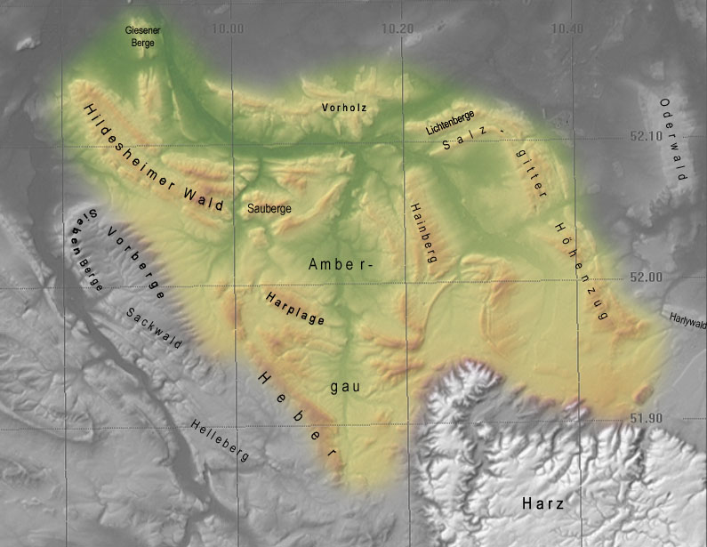
The Innerste Uplands (german: Innerstebergland) is a landscape region up to 359 m high and covering an area of over 900 km² in the northern part of the German Central Uplands. It lies within the eastern part of the Weser-Leine Uplands in Lower Saxony (Germany). The Innerste Uplands gets its name from the Innerste, a tributary of the River Leine. Geography Location The Innerste Uplands cover the catchment area of the Innerste southeast of Hildesheim and southwest to south of Salzgitter as far as Goslar and Seesen on the northwestern edge of the Harz. To the north the area is bounded by the Hildesheim Börde, to the west by the Leine Uplands and to the southeast by the North Harz Foreland. Its central and southern areas are dominated by the Ambergau, a depression dissected by the Nette, a tributary of the Innerste. In and around the Innerste Uplands there are the following clearly defined ridges, most of which are cuestas and some of which lie on the boundary wit ... [...More Info...] [...Related Items...] OR: [Wikipedia] [Google] [Baidu] |
Lichtenberge
The Salzgitter Hills (german: Salzgitter-Höhenzug, also ''Salzgitterscher Höhenzug'') is an area of upland up to in height, in the Lower Saxon Hills between Salzgitter and Goslar in the districts of Wolfenbüttel and Goslar and in the territory of the independent town of Salzgitter. The hills lie in the German federal state of Lower Saxony. The German name of is a term used in the northern Harz Foreland, albeit not found on maps, and is used to mean the string of hills north of the Harz Mountains between the towns mentioned above. The state forest of the Salzgitter Hills is managed by several Lower Saxony forestry offices, including the in Salzgitter-Salder. The Salzgitter Hills can be divided into these four unnamed sections: * Northwest section (mainly comprising the Lichtenberge)(up to 254.2 m high; between Holle and Salzgitter-Gebhardshagen) * North-central section(up to 275.3 m high; between Salzgitter-Gebhardshagen and Salzgitter-Bad) * South-central sectio ... [...More Info...] [...Related Items...] OR: [Wikipedia] [Google] [Baidu] |
Ambergau
The Ambergau is a historic landscape and natural region unit in the Innerste Uplands in southern Lower Saxony, Germany. It is a basin, about 10 x 10 kilometres across, with 18 settlements (there were 31 in the Middle Ages), the centre and capital of which since the 13th century is the town of Bockenem. The basin, with its fertile agricultural fields, is surrounded by the wooded ridges of Heber, the Harplage, the Weinberg and the Hainberg. The '' Gau'' is a cultural landscape that was formed as early as the 8th century. Name The name Ambergau is a combination of the German words ''Amber'' and ''Gau''. ''Amber'' has its origin in the Proto-Indo-European language and has the word stem ''mb(h)'', was means something like dampness. That is probably related to the wet areas that existed at that time, like those of the River Nette. Gau is a word for the enclosed settlement area of Germanic peoples. The term ''Ambergo'' was also used. Location and land use The Ambergau lie ... [...More Info...] [...Related Items...] OR: [Wikipedia] [Google] [Baidu] |
Harz Foreland
The Harz () is a highland area in northern Germany. It has the highest elevations for that region, and its rugged terrain extends across parts of Lower Saxony, Saxony-Anhalt, and Thuringia. The name ''Harz'' derives from the Middle High German word ''Hardt'' or ''Hart'' (hill forest). The name ''Hercynia'' derives from a Celtic name and could refer to other mountain forests, but has also been applied to the geology of the Harz. The Brocken is the highest summit in the Harz with an elevation of above sea level. The Wurmberg () is the highest peak located entirely within the state of Lower Saxony. Geography Location and extent The Harz has a length of , stretching from the town of Seesen in the northwest to Eisleben in the east, and a width of . It occupies an area of , and is divided into the Upper Harz (''Oberharz'') in the northwest, which is up to 800 m high, apart from the 1,100 m high Brocken massif, and the Lower Harz (''Unterharz'') in the east which is up to aroun ... [...More Info...] [...Related Items...] OR: [Wikipedia] [Google] [Baidu] |
River
A river is a natural flowing watercourse, usually freshwater Fresh water or freshwater is any naturally occurring liquid or frozen water containing low concentrations of dissolved salts and other total dissolved solids. Although the term specifically excludes seawater and brackish water, it does include ..., flowing towards an ocean, sea, lake or another river. In some cases, a river flows into the ground and becomes dry at the end of its course without reaching another body of water. Small rivers can be referred to using names such as Stream#Creek, creek, Stream#Brook, brook, rivulet, and rill. There are no official definitions for the generic term river as applied to Geographical feature, geographic features, although in some countries or communities a stream is defined by its size. Many names for small rivers are specific to geographic location; examples are "run" in some parts of the United States, "Burn (landform), burn" in Scotland and northeast England, and "be ... [...More Info...] [...Related Items...] OR: [Wikipedia] [Google] [Baidu] |
Vorholz
The Vorholz is a ridge up to 243 m high in the districts of Hildesheim and Wolfenbüttel in the German state of Lower Saxony. Geography The heavily-wooded Vorholz is located in the north of the Innerste Uplands, part of the Lower Saxon Hills. It lies north of the valley of the River Innerste between the ridges of Lichtenberge (northwestern section of the Salzgitter Hills) to the southeast, the Hainberg to the south-southeast, the Sauberge to the south-southwest and the Hildesheim Forest to the west-southwest. It is also east-southeast of the city of Hildesheim and west of Salzgitter between Schellerten in the north, Burgdorf in the east-northeast and Holle in the south. Description The Vorholz attains its highest point on the summit of the Knebelberg, 243 m high, and is the source region for several tributaries of the Innerste (which touches it tangentially in the south) and the Fuhse (which is some way to the northeast). It is crossed by numerous walking a ... [...More Info...] [...Related Items...] OR: [Wikipedia] [Google] [Baidu] |
Sauberge The Sauberge is a hill range up to in the Innerste Uplands in the district of Hildesheim in eastern Lower Saxony in Germany. Geography Location The wooded Sauberge is located in the centre of the northern part of the Innerste Uplands, a northeastern part of the Lower Saxon Hills, and borders on the historic Ambergau region. The hills extend east of the Hildesheim Forest, from Bad Salzdetfurth and the narrow valley of the Lamme to Derneburg. Hackenstedt is located in a broad valley east of the Bünte. A few kilometres east-northeast lies Holle and some distance away to the south-east is Bockenem; a few individual districts of these town boroughs reach as far as the ridge. On |


