|
Hwanggumpyong Island
Hwanggumpyong (, zh, s=黄金坪, t=黃金坪, p=Huángjīnpíng), formerly called Hwanggumpyong Island (, zh, s=黄金坪岛, t=黃金坪島, p=Huángjīnpíng Dǎo), is a North Korean free-trade zone bordering China. The area used to be a tidal island in the Yalu River. However, due to continuous deposition of river-borne sediments, the northern portion of the former island is now permanently connected with the Chinese city of Dandong. A steel mesh fence has been built to mark the land border between North Korea and China. Due to ethnic Koreans living on the island at the time of a 1962 border treaty, both China and North Korea agreed that the sovereignty of the island belongs to North Korea. The former river island is now a North Korean exclave on the otherwise Chinese side of the river. The agreement is not recognized by South Korea, who continues to claim this island in accordance with its constitution. History In June 2011, an agreement, negotiated by Gao Jingde, of Sun ... [...More Info...] [...Related Items...] OR: [Wikipedia] [Google] [Baidu] |
Yalu River
The Yalu River () or Amnok River () is a river on the border between China and North Korea. Together with the Tumen River to its east, and a small portion of Paektu Mountain, the Yalu forms the border between China and North Korea. Its valley has been the scene of several military conflicts in the past centuries. It borders North Korea to the south and China to the north. Name The Chinese name ''Yalu'' ("duck-green") was first attested during the Tang dynasty. According to the '' Tongdian'' (8th century), the river was named after its color, which resembled that of a mallard's head. The Korean name "Amnok" follows the Sino-Korean reading of the same name. In ancient times, the river was known as ''Peishui'' (''Paesu'', 浿水) or ''Mazishui'' (''Majasu'', 馬訾水). Historically, it was also known by the Korean name of ''Arinarye'' (아리나례강, 阿利那禮江). ''Ari'', a word from Old Korean used to refer to the 'spirituality (신령성; 神靈性) of the sun'. Th ... [...More Info...] [...Related Items...] OR: [Wikipedia] [Google] [Baidu] |
Dandong
Dandong ( zh, s=丹东 , t=丹東 , p=Dāndōng; lit. "Red East"), formerly known as Andong, is a coastal prefecture-level city in southeastern Liaoning province, in the northeastern region of the People's Republic of China. It is the largest Chinese border city, facing Sinuiju, North Korea, across the Yalu River, which demarcates the Sino-North Korean border. To the southwest of the city, the river flows into Korea Bay. Dandong has therefore had a dynamic history because of its strategic location for the northeast's rich natural resources and because of its convenient access to the ocean. It is designated as a major export production centre for the province, and is a port city connected by rail with Shenyang and Sinuiju. A significant amount of trade with North Korea flows through the city. Kanto, Dick K. and Mark E. Manyin. ''China-North Korea Relations''. DIANE Publishing. December 28, 2010.10 Retrieved from Google Books on October 23, 2012. , 9781437985115. The si ... [...More Info...] [...Related Items...] OR: [Wikipedia] [Google] [Baidu] |
Wihwa Island
Wihwa Island (, ''Wihwado'', ) is a river island in the Yalu river, lying on the border between North Korea and China. It is now under the effective jurisdiction of North Korea, due to ethnic Koreans living on the island at the time of the 1962 border treaty. Wihwa Island is historically well known for being where General Yi Songgye decided, in 1392, to turn back his army southward to Kaesong Kaesong (, ; ) is a special city in the southern part of North Korea (formerly in North Hwanghae Province), and the capital of Korea during the Taebong kingdom and subsequent Goryeo dynasty. The city is near the Kaesong Industrial Region cl ... in the first of a series of revolts that eventually led to the establishment of the Yi Dynasty. In June 2011, an agreement with China was made to establish a joint free trade area on Hwanggumpyong and Wihwa Islands, and the China border area near Dandong. References River islands of North Korea {{NorthKorea-geo-stub ... [...More Info...] [...Related Items...] OR: [Wikipedia] [Google] [Baidu] |
Free-trade Area
A free trade area is the region encompassing a trade bloc whose member countries have signed a free trade agreement (FTA). Such agreements involve cooperation between at least two countries to reduce trade barriers, import quotas and tariffs, and to increase trade of goods and services with each other. If natural persons are also free to move between the countries, in addition to a free trade agreement, it would also be considered an open border. It can be considered the second stage of economic integration. Customs unions are a special type of free trade area. All such areas have internal arrangements which parties conclude in order to liberalize and facilitate trade among themselves. The crucial difference between customs unions and free trade areas is their approach to third parties. While a customs union requires all parties to establish and maintain identical external tariffs with regard to trade with non-parties, parties to a free trade area are not subject to this requiremen ... [...More Info...] [...Related Items...] OR: [Wikipedia] [Google] [Baidu] |
Yonhap News Agency
Yonhap News Agency (; ) is a major news agency in South Korea. It is based in Seoul, South Korea. Yonhap provides news articles, pictures, and other information to newspapers, TV networks and other media in South Korea. History Yonhap was established on 19 December 1980, through the merger of Hapdong News Agency and Orient Press. The Hapdong News Agency itself emerged in late 1945 out of the short-lived Kukje News, which had operated for two months out of the office of the Domei, the former Japanese news agency that had functioned in Korea during the Japanese Japanese colonial era. In 1999, Yonhap took over the Naewoe News Agency. Naewoe was a South Korea government-affiliated organization, created in the mid 1970s, tasked with publishing information and analysis on North Korea from a South Korean perspective through books and journals. Naewoe was known to have close links with South Korea's intelligence agency, and according to the British academic and historian James Hoar ... [...More Info...] [...Related Items...] OR: [Wikipedia] [Google] [Baidu] |
Gao Jingde
Gunter Gao Jingde (, also known as Ko King-tak) is a member of the Chinese People's Political Consultative Conference (CPPCC) of the People's Republic of China. In April 2010, he was vice-chairman of its Committee of Education, Science, Culture, Health and Sports. Gao is chairman of Hong Kong private investment company Sunbase International (Holdings) Ltd (), established in 1991. The business is active in property investment, transport, infrastructure and technology sectors. A subsidiary, Sunbase International Properties Management Limited, manages all 19 military sites held by the People’s Liberation Army in Hong Kong and provides services to the Hong Kong Government and the Hong Kong branch of the Xinhua news agency. In June 2011, it was reported that Gao had made two visits to North Korea in 2010 and had secured rights to develop Hwanggumpyong Island as an industrial complex. The island is located at the estuary of the Yalu River, between China's and North Korea's border ci ... [...More Info...] [...Related Items...] OR: [Wikipedia] [Google] [Baidu] |
Constitution Of South Korea
The Constitution of the Republic of Korea () is the supreme law of South Korea. It was promulgated on July 17, 1948, and last revised on October 29, 1987. Background The Provisional Charter of Korea The preamble of the Constitution of South Korea states that the document was established in the spirit of "upholding the cause of the Provisional Republic of Korea Government", the Korean government exiled after the imposition of Japanese colonial rule of Korea. As such, the founding document of the provisional government—The Provisional Charter of Korea—serves as the basis for the current constitution. Promulgated in 1919, the charter first gave the country the "Republic of Korea" name and laid out the ideas forming the backbone of later South Korean constitutions. These ten articles are: # The Republic of Korea is a democratic republic. # The Provisional Government governs the Republic of Korea under resolutions of the Provisional Assembly. # All citizens of the Republi ... [...More Info...] [...Related Items...] OR: [Wikipedia] [Google] [Baidu] |
South Korea
South Korea, officially the Republic of Korea (ROK), is a country in East Asia. It constitutes the southern half of the Korea, Korean Peninsula and borders North Korea along the Korean Demilitarized Zone, with the Yellow Sea to the west and the Sea of Japan to the east. Like North Korea, South Korea claims to be the sole legitimate government of the entire peninsula and List of islands of South Korea, adjacent islands. It has Demographics of South Korea, a population of about 52 million, of which half live in the Seoul Metropolitan Area, the List of largest cities, ninth most populous metropolitan area in the world; other major cities include Busan, Daegu, and Incheon. The Korean Peninsula was inhabited as early as the Lower Paleolithic period. Gojoseon, Its first kingdom was noted in Chinese records in the early seventh century BC. From the mid first century BC, various Polity, polities consolidated into the rival Three Kingdoms of Korea, kingdoms of Goguryeo, Baekje, and Sil ... [...More Info...] [...Related Items...] OR: [Wikipedia] [Google] [Baidu] |
Digital Chosun
''The Chosun Ilbo'' (, ), also known as ''The Chosun Daily,'' is a Korean-language newspaper of record for South Korea and among the oldest active newspapers in the country. With a daily circulation of more than 1,800,000, ''The'' ''Chosun Ilbo'' has been audited annually since the Audit Bureau of Circulations was established in 1993. ''The'' ''Chosun Ilbo'' and its subsidiary company, Digital Chosun, operate the ''Chosun.com'' news website, which also publishes news in English, Chinese, and Japanese. History The Chosun Ilbo Establishment Union was created in September 1919. ''The'' ''Chosun Ilbo'' newspaper was founded on 5 March 1920 by Sin Sogu with the financial support of the Daejong Business Association. Cho Jin-Tae, the vice-chairman of the Daejong Business Association was appointed the first President of the newspaper in 1920. However, as the Business Association failed to pay promised finances, the relationship between the Association and ''The Chosun Ilbo'' broke down ... [...More Info...] [...Related Items...] OR: [Wikipedia] [Google] [Baidu] |
Enclave And Exclave
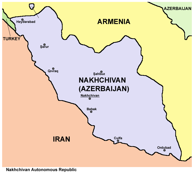
An enclave is a territory that is entirely surrounded by the territory of only one other state or entity. An enclave can be an independent territory or part of a larger one. Enclaves may also exist within territorial waters. ''Enclave'' is sometimes used improperly to denote a territory that is only partly surrounded by another state. Enclaves that are not part of a larger territory are not exclaves, for example Lesotho (enclaved by South Africa), and San Marino and Vatican City (both enclaved by Italy) are enclaved sovereign states. An exclave is a portion of a state or district geographically separated from the main part, by some surrounding alien territory. Many exclaves are also enclaves, but an exclave surrounded by the territory of more than one state is not an enclave. The Azerbaijani exclave of Nakhchivan is an example of an exclave that is not an enclave, as it borders Armenia, Iran, and Turkey. Semi-enclaves and semi-exclaves are areas that, except for possessing ... [...More Info...] [...Related Items...] OR: [Wikipedia] [Google] [Baidu] |
River Island
River Island (stylised as RiverIsland and abbreviated as RI) is a London-based, multi-channel fashion brand, founded in 1948 by Bernard Lewis (entrepreneur), Bernard Lewis. The retailer has a presence in over 125 of worldwide markets, in stores and online. Best known for its trend focused womenswear offering, River Island also has menswear, kidswear and pet collections. River Island's collections are entirely designed in-house at the brand's West London head office, and it was one of the first vertical fashion retailers in the UK. In the 1960s, it became an influential name in the womenswear fashion scene, under its previous name: Chelsea Girl. Today, River Island is considered a key player on the UK high street, with 250 stores across the country, including flagship locations in London, Liverpool, Manchester and Birmingham, plus a significant online presence. In recent years, the business has expanded internationally, and continued to grow its online offer. River Island is a ... [...More Info...] [...Related Items...] OR: [Wikipedia] [Google] [Baidu] |
Sino–North Korean Border Treaty
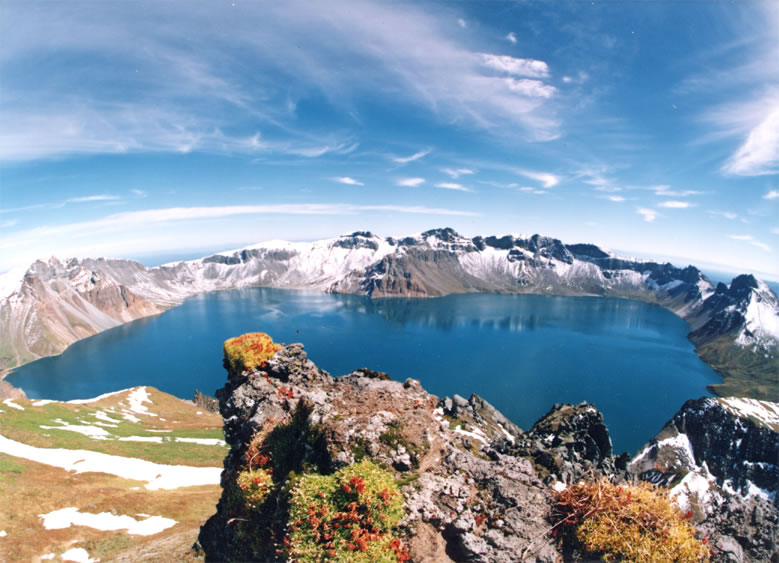
The Sino-Korean Border Agreement ( zh, s=中朝边界条约; ) was signed by China and North Korea on October 12, 1962, in Pyongyang. This agreement and a subsequent agreement in 1964 define the modern border between the two countries. The agreement is widely viewed by both modern scholars and by contemporaries as being favorable to North Korea. As a result of the agreement, North Korea acquired of territory on and around Paektu Mountain, and 54.5% of the mountain's Heaven Lake. The previous practice of using the Yalu River and Tumen River for the rest of the border was affirmed. A subsequent agreement followed on March 20, 1964, called the Protocols on the Sino-Korean Border ( zh, s=中朝边界议定书, links=no; ). It was signed in Beijing and determined the sovereignty of 451 islands and islets (264 to North Korea, 187 to China). Both agreements were made in secret, never registered with the United Nations Secretariat, and never publicly confirmed. However, in 2000, the ... [...More Info...] [...Related Items...] OR: [Wikipedia] [Google] [Baidu] |


