|
Hurura
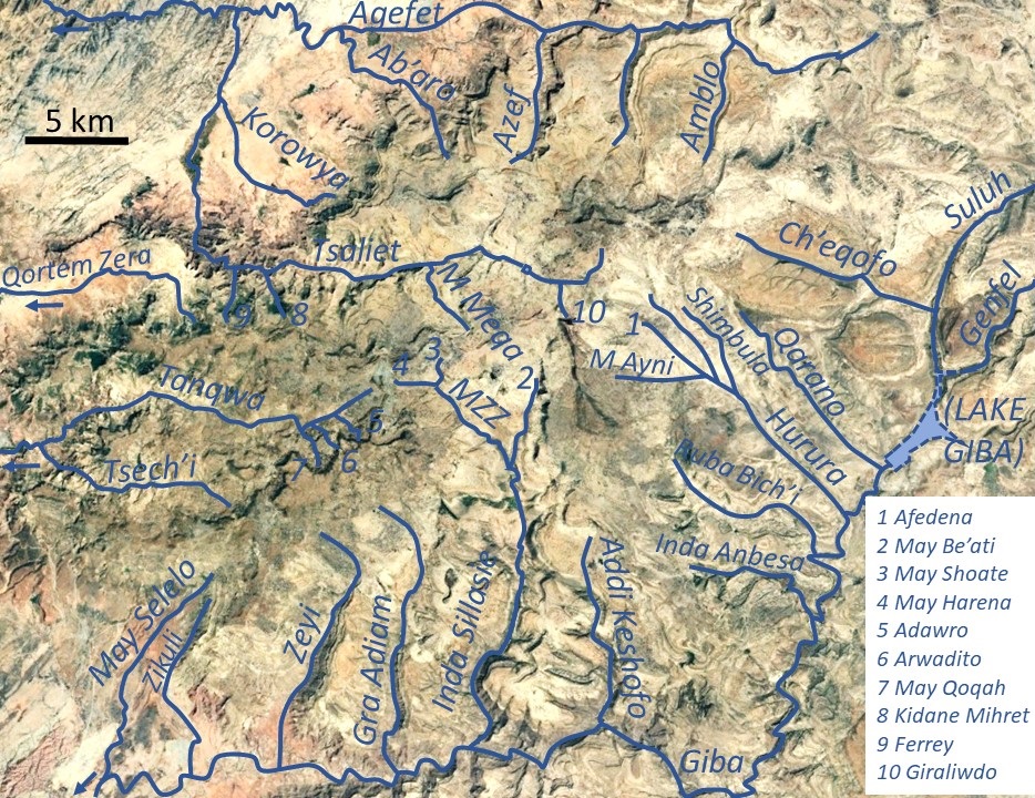
Hurura is a river of the Nile basin. Rising in the mountains of Dogu’a Tembien in northern Ethiopia, it flows southwestward to empty in Giba and finally in Tekezé River. Characteristics It is a confined ephemeral river, locally meandering in its narrow alluvial plain, with an average slope gradient of 33 metres per kilometre. With its tributaries, the river has cut a deep gorge. Flash floods and flood buffering Runoff mostly happens in the form of high runoff discharge events that occur in a very short period (called flash floods). These are related to the steep topography, often little vegetation cover and intense convective rainfall. The peaks of such flash floods have often a 50 to 100 times larger discharge than the preceding baseflow. The magnitude of floods in this river has however been decreased due to interventions in the catchment. At Afedena, Sesemat, Tukhul and on other steep slopes, exclosures have been established; the dense vegetation largely contributes ... [...More Info...] [...Related Items...] OR: [Wikipedia] [Google] [Baidu] |
Degua Tembien
Dogu'a Tembien (, "Upper Tembien", sometimes transliterated as Degua Tembien) is a woreda in Tigray Region, Ethiopia. It is named in part after the former province of Tembien. Nowadays, the mountainous district is part of the Southeastern Tigray Zone. The administrative centre of this woreda is Hagere Selam. History Dogu’a Tembien holds numerous prehistoric sites, which have been dated to the Middle Stone Age in Ayninbirkekin, or Pastoral Neolithic in Aregen and Menachek. Geography Topography and landscapes Major mountains :* Tsatsen, 2815 metres, a wide mesa between Hagere Selam and Inda Maryam Qorar () :* Ekli Imba, 2799 metres, summit of the Arebay massif in Arebay ''tabia'' or district () :* Imba Zuw’ala, 2710 metres, near Hagere Selam () :* Aregen, 2660 metres, in Aregen ''tabia'' () :* Dabba Selama, 2630 metres, in Haddinnet ''tabia'' () (not to be confused with the homonymous monastery) :* Imba Dogu’a, 2610 metres, in Mizane Birhan ''tabia'' () :* I ... [...More Info...] [...Related Items...] OR: [Wikipedia] [Google] [Baidu] |
Giba River
Giba is a river of northern Ethiopia. It starts at the confluence of Genfel and Sulluh (which rises in the mountains of Mugulat) (3298 metres above sea level) and flows westward to the Tekezé River. Future Lake Giba will occupy the plain where Sulluh, Genfel and Agula'i Rivers meet, and hence be the future source of Giba River. Hydrography It is a confined river, locally meandering in its narrow alluvial plain, with a slope gradient of 7 metres per kilometre. With its tributaries, the river has cut a deep gorge. Tributaries Main tributaries, from downstream to upstream, are * Tanqwa ** Tsech'i River ** May Qoqah ** Arwadito ** Adawro River * May Selelo * Zikuli River * Gra Adiam River, also called Bitchoqo River * Zeyi River * Inda Sillasie River ** May Zegzeg *** May Harena *** May Sho'ate ** May Be'ati River * Addi Keshofo River * May Gabat * Inda Anbesa * Ruba Bich'i River * Hurura ** Afedena River *** May Ayni ** Shimbula * Ilala River * Qarano ... [...More Info...] [...Related Items...] OR: [Wikipedia] [Google] [Baidu] |
Shimbula
Shimbula is a river of the Nile basin. Rising in the mountains of Dogu’a Tembien in northern Ethiopia, it flows southwestward to empty finally in Giba and Tekezé River. Characteristics It is a confined ephemeral river, locally meandering in its narrow alluvial plain, with an average slope gradient of 38 metres per kilometre. With its tributaries, the river has cut a deep gorge. Flash floods and flood buffering Runoff mostly happens in the form of high runoff discharge events that occur in a very short period (called flash floods). These are related to the steep topography, often little vegetation cover and intense convective rainfall. The peaks of such flash floods have often a 50 to 100 times larger discharge than the preceding baseflow. The magnitude of floods in this river has however been decreased due to interventions in the catchment. On steep slopes, exclosures have been established; the dense vegetation largely contributes to enhanced infiltration, less flooding a ... [...More Info...] [...Related Items...] OR: [Wikipedia] [Google] [Baidu] |
Afedena River
Afedena is a river of the Nile basin. Rising in the mountains of Dogu’a Tembien in northern Ethiopia, it flows southwestward to empty finally in Giba and Tekezé River. Characteristics It is a confined ephemeral river, locally meandering in its narrow alluvial plain, with an average slope gradient of 35 metres per kilometre. With its tributaries, the river has cut a gorge. Flash floods and flood buffering Runoff mostly happens in the form of high runoff discharge events that occur in a very short period (called flash floods). These are related to the steep topography, often little vegetation cover and intense convective rainfall. The peaks of such flash floods have often a 50 to 100 times larger discharge than the preceding baseflow. The magnitude of floods in this river has however been decreased due to interventions in the catchment. At Afedena, exclosures have been established; the dense vegetation largely contributes to enhanced infiltration, less flooding and better ... [...More Info...] [...Related Items...] OR: [Wikipedia] [Google] [Baidu] |
Dolerite
Diabase (), also called dolerite () or microgabbro, is a mafic, holocrystalline, subvolcanic rock equivalent to volcanic basalt or plutonic gabbro. Diabase dikes and sills are typically shallow intrusive bodies and often exhibit fine-grained to aphanitic chilled margins which may contain tachylite (dark mafic glass). ''Diabase'' is the preferred name in North America, while ''dolerite'' is the preferred name in the rest of the English-speaking world, where sometimes the name ''diabase'' refers to altered dolerites and basalts. Some geologists prefer to avoid confusion by using the name ''microgabbro''. The name ''diabase'' comes from the French ', and ultimately from the Greek - meaning "act of crossing over, transition". Petrography Diabase normally has a fine but visible texture of euhedral lath-shaped plagioclase crystals (62%) set in a finer matrix of clinopyroxene, typically augite (20–29%), with minor olivine (3% up to 12% in olivine diabase), magnetite (2%), and i ... [...More Info...] [...Related Items...] OR: [Wikipedia] [Google] [Baidu] |
Amba Aradam Formation
The Amba Aradam Formation is a Cretaceous sandstone formation in Ethiopia. It is up to 200 metres thick, for instance in the Degua Tembien district. As fossils are absent, the age of the Amba Aradam Formation was interpreted based on the age of assumed corresponding sandstones elsewhere in Ethiopia: the Debre Libanos Sandstones in the Blue Nile Basin, and the Upper Sandstone near Harrar in southeast Ethiopia, both of Late Cretaceous age (100–66 million years ago). The lithology of the Amba Aradam Formation makes it less suitable for rock church excavation; caves have however been blasted in this formation to serve as headquarters for the TPLF during the Ethiopian Civil War of the 1980s. Name and definition The name “Amba Aradam Sandstone” was coined by geologist William Thomas Blanford, who accompanied the British invading army in 1868. The formation is named after the Amba Aradam mountain, where the formation widely outcrops. So far the nomenclature was not proposed for ... [...More Info...] [...Related Items...] OR: [Wikipedia] [Google] [Baidu] |
Antalo Limestone
The Antalo Limestone, also known as the Antalo Sequence, is a geological formation in Ethiopia. It is between 300 and 800 metres thick and comprises fossiliferous limestones and marls that were deposited in a reef. Marine microfossils have shown an age between 165 and 150 million years. Name and definition The Antalo Supersequence includes two main stratigraphic units: the Antalo Sequence and the Agula Group. The Antalo Sequence, or Antalo Limestone has been named after the town of Hintalo in Tigray, Ethiopia. The name of the formation was coined by geologist William Thomas Blanford, who accompanied the British Expedition to Abyssinia in 1868. At that time, Hintalo was a major town on the route of the invading British army. So far the nomenclature has not been proposed for recognition to the International Commission on Stratigraphy. Geographical extent The sedimentary succession is found in Ethiopia, in the Mekelle Outlier, in the Blue Nile gorge, in the Harrar Plateau an ... [...More Info...] [...Related Items...] OR: [Wikipedia] [Google] [Baidu] |
Exclosure
An exclosure, in an area being used extensively for grazing, is a limited area from which unwanted browsing animals, such as domestic cattle or wildlife such as deer, are excluded by fencing or other means. Environmental protection Most commonly, exclosures are areas that are set aside for regreening. Wood harvesting and livestock range are not allowed there. Effects on environment The establishment of an exclosure has positive effects on: * biodiversity * water infiltration * protection from flooding * sediment deposition * carbon sequestration Economic benefits In developing countries, people commonly have economic benefits from these exclosures through grass harvesting, beekeeping and other non-timber forest products. The local inhabitants also consider it as “land set aside for future generations”. Carbon credits Exclosures have as an additional benefit that the surrounding communities may receive carbon credits for the sequestered CO2, as part of a carbon o ... [...More Info...] [...Related Items...] OR: [Wikipedia] [Google] [Baidu] |
Ashangi Basalts
The Ashangi Basalts are the earliest Tertiary volcanic rocks in north Ethiopia, hence they are in the lowest position. These dark porphyritic basalts are separated from the Mesozoic formations below it by basal conglomerates. The basalts hold phenocrysts that developed before the magma reached the earth surface. These basalts are weathered, partially eroded and have a sub-horizontal stratification, particularly at the lower part. This series was created during the first period of the flood basalt eruptions in north Ethiopia, in the Oligocene. Name and definition The name was coined by geologist William Thomas Blanford, who accompanied the British Expedition to Abyssinia in 1868,{{cite book , last1=Blanford , first1=W.T. , title=Observations on the geology and zoology of Abyssinia, made during the progress of the British expedition to that country in 1867-68 , url=https://archive.org/details/cu31924024736666 , date=1870 , publisher=Macmillan and Co. , location=London after Lake Ha ... [...More Info...] [...Related Items...] OR: [Wikipedia] [Google] [Baidu] |
Intra-volcanic Sedimentary Rock In North Ethiopia
Between 29 and 27 million years ago, the extrusion of Ethiopia’s flood basalts was interrupted and deposition of continental sediments occurred. Inter-trappean beds outcrop in many places of the Ethiopian highlands. They consist of fluvio-lacustrine deposits, that are generally a few tens of metres thick. Often, these interbedded fluvio-lacustrine deposits are very visible because their bright colours strongly contrast with the basalt environment. Name and definition The formation, also called ''silicified limestone'' and ''interbedded lacustrine deposits'' was first extensively characterised in the 1930s by Merla and Minucci. Stratigraphic context The formation is generally at the interface between the lower Ashangi Basalts, and the upper Alaji Basalts. Environment The sediments were deposited in shallow lakes and marshes in large topographic depressions. The dense vegetation hosted mammals and birds, which found their food between the reeds of the lake shores. The decompos ... [...More Info...] [...Related Items...] OR: [Wikipedia] [Google] [Baidu] |
Alaji Basalts
The Alaji (upper) Basalts are the youngest series of the Ethiopian flood basalts. The most recent flows are only 15 million years old. Name and definition The name was coined by geologist William Thomas Blanford, who accompanied the British Expedition to Abyssinia in 1868, after the Imba Alaje mountain. So far the nomenclature has not been proposed for recognition to the International Commission on Stratigraphy. Stratigraphic context Uppermost Tertiary flood basalts in Ethiopia. Locally they are covered by Pliocene shield volcanoes, such as the Simien Mountains, or Mount Guna. These flows have been deposited on the lower Ashangi Basalts and locally on intra-volcanic sedimentary rock. Environment Like all volcanic rocks, the Alaji Basalts originate from initial melting of the Earth's mantle. After extrusion, the magmatic structures form at the surface. Common volcanic structures such as lava tubes or ropy lavas are absent in the Alaji Basalts, but ( columnar joints) are omnipr ... [...More Info...] [...Related Items...] OR: [Wikipedia] [Google] [Baidu] |


