|
Hurricane Julia (2010)
Hurricane Julia was the easternmost Category 4 hurricane recorded in the Atlantic basin since reliable satellite observations became available. The twelfth tropical cyclone, fifth hurricane and fourth major hurricane of the 2010 Atlantic hurricane season, Julia rapidly developed on September 12 from a tropical wave near Cape Verde. Passing near the islands, the system quickly organized into Tropical Storm Julia the next day. On September 14, Julia attained hurricane status and subsequently entered a trend of rapid intensification; the storm strengthened from a minimal hurricane to a low-end Category 4 in only 24 hours. After peaking in intensity, further development was impeded as interaction with nearby Hurricane Igor began to occur; the storm was downgraded to a tropical storm by September 18. It subsequently moved into a region of unfavorable conditions, heading toward lower sea surface temperatures. Correspondingly, Julia entered an extra ... [...More Info...] [...Related Items...] OR: [Wikipedia] [Google] [Baidu] |
Cape Verde Islands
Cape Verde or Cabo Verde, officially the Republic of Cabo Verde, is an island country and archipelagic state of West Africa in the central Atlantic Ocean, consisting of ten volcanic islands with a combined land area of about . These islands lie between west of Cap-Vert, the westernmost point of continental Africa. The Cape Verde islands form part of the Macaronesia ecoregion, along with the Azores, the Canary Islands, Madeira and the Savage Isles. The Cape Verde archipelago was uninhabited until the 15th century, when Portuguese explorers colonized the islands, establishing one of the first European settlements in the tropics. Due to its strategic position, Cape Verde became a significant location in the transatlantic slave trade during the 16th and 17th centuries. The islands experienced economic growth during this period, driven by their role by the rapid emergence of merchants, privateers, and pirates. It declined economically in the 19th century, and many of its inh ... [...More Info...] [...Related Items...] OR: [Wikipedia] [Google] [Baidu] |
Atmospheric Pressure
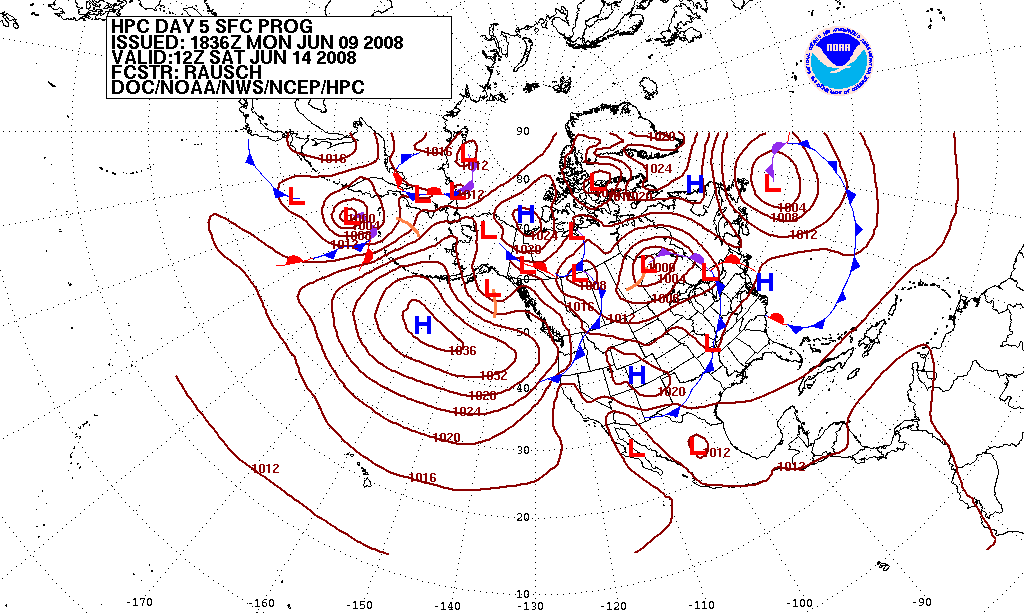
Atmospheric pressure, also known as air pressure or barometric pressure (after the barometer), is the pressure within the atmosphere of Earth. The standard atmosphere (symbol: atm) is a unit of pressure defined as , which is equivalent to 1,013.25 millibars, 760 mm Hg, 29.9212 inchesHg, or 14.696 psi.International Civil Aviation Organization. ''Manual of the ICAO Standard Atmosphere'', Doc 7488-CD, Third Edition, 1993. . The atm unit is roughly equivalent to the mean sea-level atmospheric pressure on Earth; that is, the Earth's atmospheric pressure at sea level is approximately 1 atm. In most circumstances, atmospheric pressure is closely approximated by the hydrostatic pressure caused by the weight of air above the measurement point. As elevation increases, there is less overlying atmospheric mass, so atmospheric pressure decreases with increasing elevation. Because the atmosphere is thin relative to the Earth's radius—especially the dense atmospheric layer at low altitu ... [...More Info...] [...Related Items...] OR: [Wikipedia] [Google] [Baidu] |
Cold-core Low
A cold-core low, also known as an upper level low or cold-core cyclone, is a cyclone aloft which has an associated cold pool of air residing at high altitude within the Earth's troposphere, without a frontal structure. It is a low pressure system that strengthens with height in accordance with the thermal wind relationship. If a weak surface circulation forms in response to such a feature at subtropical latitudes of the eastern north Pacific or north Indian oceans, it is called a subtropical cyclone. Cloud cover and rainfall mainly occurs with these systems during the day. Severe weather, such as tornadoes, can occur near the center of cold-core lows. Cold lows can help spawn cyclones with significant weather impacts, such as polar lows, and Kármán vortices. Cold lows can lead directly to the development of tropical cyclones, owing to their associated cold pool of air aloft or by acting as additional outflow channels to aid in further development. Characteristics Cold ... [...More Info...] [...Related Items...] OR: [Wikipedia] [Google] [Baidu] |
Inches Of Mercury
Inch of mercury (inHg, ″Hg, or in) is a non- SI unit of measurement for pressure. It is used for barometric pressure in weather reports, refrigeration and aviation in the United States. It is the pressure exerted by a column of mercury in height at the standard acceleration of gravity. Conversion to metric units depends on the density of mercury, and hence its temperature; typical conversion factors are: In older literature, an "inch of mercury" is based on the height of a column of mercury at .Barry N. Taylor, ''Guide for the Use of the International System of Units (SI),'' 1995, NIST Special Publication 811, Appendix /ref> :1 inHg60 °F = In Imperial units: 1 inHg60 °F = 0.489 771 Pounds per square inch, psi, or 2.041 771 inHg60 °F = 1 psi. Applications Aircraft and automobiles Aircraft altimeters measure the relative pressure difference between the lower ambient pressure at altitude and a calibrated reading on the ground ... [...More Info...] [...Related Items...] OR: [Wikipedia] [Google] [Baidu] |
Pascal (unit)
The pascal (symbol: Pa) is the unit of pressure in the International System of Units (SI). It is also used to quantify internal pressure, stress, Young's modulus, and ultimate tensile strength. The unit, named after Blaise Pascal, is an SI coherent derived unit defined as one newton per square metre (N/m2). It is also equivalent to 10 barye (10 Ba) in the CGS system. Common multiple units of the pascal are the hectopascal (1 hPa = 100 Pa), which is equal to one millibar, and the kilopascal (1 kPa = 1000 Pa), which is equal to one centibar. The unit of measurement called '' standard atmosphere (atm)'' is defined as . Meteorological observations typically report atmospheric pressure in hectopascals per the recommendation of the World Meteorological Organization, thus a standard atmosphere (atm) or typical sea-level air pressure is about 1013 hPa. Reports in the United States typically use inches of mercury or millibars (hectopascals). In Cana ... [...More Info...] [...Related Items...] OR: [Wikipedia] [Google] [Baidu] |
Bar (unit)
The bar is a metric unit of pressure defined as 100,000 Pa (100 kPa), though not part of the International System of Units (SI). A pressure of 1 bar is slightly less than the current average atmospheric pressure on Earth at sea level (approximately 1.013 bar). By the barometric formula, 1 bar is roughly the atmospheric pressure on Earth at an altitude of 111 metres at 15 °C. The bar and the millibar were introduced by the Norwegian meteorologist Vilhelm Bjerknes, who was a founder of the modern practice of weather forecasting, with the bar defined as one megadyne per square centimetre. The SI brochure, despite previously mentioning the bar, now omits any mention of it.. The bar has been legally recognised in countries of the European Union since 2004. British Standard BS 350:2004 ''Conversion Factors for Units''. The US National Institute of Standards and Technology (NIST) deprecates its use except for "limited use in meteorology" and lists ... [...More Info...] [...Related Items...] OR: [Wikipedia] [Google] [Baidu] |
Tropical Cyclone Scales
Tropical cyclones are ranked on one of five tropical cyclone intensity scales, according to their maximum sustained winds and which tropical cyclone basins they are located in. Only a few classifications are used officially by the meteorological agencies monitoring the tropical cyclones, but other scales also exist, such as accumulated cyclone energy, the Power Dissipation Index, the Integrated Kinetic Energy Index, and the Hurricane Severity Index. Tropical cyclones that develop in the Northern Hemisphere are classified by the warning centres on one of three intensity scales. Tropical cyclones or subtropical cyclones that exist within the North Atlantic Ocean or the North-eastern Pacific Ocean are classified as either tropical depressions or tropical storms. Should a system intensify further and become a hurricane, then it will be classified on the Saffir–Simpson hurricane wind scale, and is based on the estimated maximum sustained winds over a 1-minute period. In the W ... [...More Info...] [...Related Items...] OR: [Wikipedia] [Google] [Baidu] |
Wind Shear
Wind shear (; also written windshear), sometimes referred to as wind gradient, is a difference in wind speed and/or direction over a relatively short distance in the atmosphere. Atmospheric wind shear is normally described as either vertical or horizontal wind shear. Vertical wind shear is a change in wind speed or direction with a change in altitude. Horizontal wind shear is a change in wind speed with a change in lateral position for a given altitude. Wind shear is a microscale meteorological phenomenon occurring over a very small distance, but it can be associated with mesoscale or synoptic scale weather features such as squall lines and cold fronts. It is commonly observed near microbursts and downbursts caused by thunderstorms, fronts, areas of locally higher low-level winds referred to as low-level jets, near mountains, radiation inversions that occur due to clear skies and calm winds, buildings, wind turbines, and sailboats. Wind shear has significant effects on ... [...More Info...] [...Related Items...] OR: [Wikipedia] [Google] [Baidu] |
Oceanic Heat Content
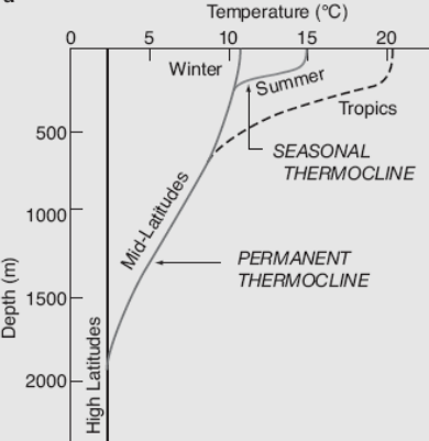
Ocean heat content (OHC) or ocean heat uptake (OHU) is the energy absorbed and stored by oceans, and is thus an important indicator of global warming. Ocean heat content is calculated by measuring ocean temperature at many different locations and depths, and integrating the areal density of a change in enthalpic energy over an ocean basin or entire ocean. Between 1971 and 2018, a steady upward trendNOAA National Centers for Environmental Information, Assessing the Global Climate in 2024, published online January 2025, Retrieved on March 2, 2025 from https://www.ncei.noaa.gov/news/global-climate-202413. in ocean heat content accounted for over 90% of Earth's excess energy from global warming. Scientists estimate a 1961–2022 warming trend of 0.43±0.08W/m², accelerating at about 0.15±0.04W/m² perdecade. By 2020, about one third of the added energy had propagated to depths below 700 meters. In 2024, the world's oceans were again the hottest in the historical record and excee ... [...More Info...] [...Related Items...] OR: [Wikipedia] [Google] [Baidu] |
Weather Satellite
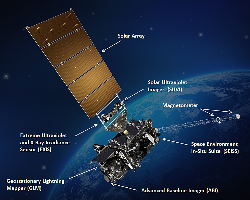
A weather satellite or meteorological satellite is a type of Earth observation satellite that is primarily used to monitor the weather and climate of the Earth. Satellites are mainly of two types: polar orbiting (covering the entire Earth asynchronously) or geostationary (hovering over the same spot on the equator). While primarily used to detect the development and movement of storm systems and other cloud patterns, meteorological satellites can also detect other phenomena such as city lights, fires, effects of pollution, auroras, sand and dust storms, snow cover, ice mapping, boundaries of ocean currents, and energy flows. Other types of environmental information are collected using weather satellites. Weather satellite images helped in monitoring the volcanic ash cloud from Mount St. Helens and activity from other volcanoes such as Mount Etna. Smoke from fires in the western United States such as Colorado and Utah have also been monitored. El Niño and its effects on wea ... [...More Info...] [...Related Items...] OR: [Wikipedia] [Google] [Baidu] |
Eye (cyclone)
The eye is a region of mostly calm weather at the center of a tropical cyclone. The eye of a storm is a roughly circular area, typically in diameter. It is surrounded by the eyewall, a ring of towering thunderstorms where the most severe weather and highest winds of the cyclone occur. The cyclone's lowest barometric pressure occurs in the eye and can be as much as 15 percent lower than the pressure outside the storm. In strong tropical cyclones, the eye is characterized by light winds and clear skies, surrounded on all sides by a towering, symmetric eyewall. In weaker tropical cyclones, the eye is less well defined and can be covered by the central dense overcast, an area of high, thick clouds that show up brightly on satellite imagery. Weaker or disorganized storms may also feature an eyewall that does not completely encircle the eye or have an eye that features heavy rain. In all storms, however, the eye is where the barometer reading is lowest. Structure A typical tropi ... [...More Info...] [...Related Items...] OR: [Wikipedia] [Google] [Baidu] |


