|
Hunsrückquerbahn
The Hunsrückquerbahn (English language, English: ''Trans-Hunsrück Railway'') is a deactivated railway located in the Hunsrück region of Rheinland-Pfalz, Germany. The line connects with the Nahe Valley Railway (''Nahetalbahn'') in Langenlonsheim to the east with the partially abandoned Hochwaldbahn in Hermeskeil to the west. It was the primary railway through the Hunsrück, having both passenger and freight services. Originally called the ''Hunsrückbahn'', the change of name occurred as adjustments to passenger service occurred between 1978 and 1984. A nearby railway and former spur route that continues to serve passenger and tourist traffic between Boppard and Emmelshausen now carries the original name, while the original railway was renamed the Hunsrückquerbahn. History The Hunsrückquerbahn was developed in stages. The first stage was completed in 1889, connecting Langenlonsheim with Simmern, the principal town of the region. Further extensions included Simmern to Kirchber ... [...More Info...] [...Related Items...] OR: [Wikipedia] [Google] [Baidu] |
Hunsrück Railway
The Hunsrück Railway () is a partially disused railway branch line in the German state of Rhineland-Palatinate, which branches from the West Rhine Railway in Boppard and used to run as far as Simmern. The 38 kilometre section south of Emmelshausen has been dismantled and has been since replaced by the '' Schinderhannes-Radweg'' cycle path. In Simmern it connected with the now partially closed Hunsrückquerbahn (''Trans-Hunsrück Railway'') between Langenlonsheim and Hermeskeil. On the 15 kilometre-long Boppard–Emmelshausen section there are regular local services operated by Rhenus Veniro as route RB 37. Many school students from Emmelshausen and Boppard-Buchholz rely on the trains and their travel was facilitated by the extension of the line from Boppard Central Station to Boppard Süd station. Name of the line The name ''Hunsrückbahn'' was given to this line only after the closure of passenger services on another line that was originally called the ''Hunsrückbahn' ... [...More Info...] [...Related Items...] OR: [Wikipedia] [Google] [Baidu] |
Nieder Kostenz
Nieder Kostenz is an '' Ortsgemeinde'' – a municipality belonging to a ''Verbandsgemeinde'', a kind of collective municipality – in the Rhein-Hunsrück-Kreis (district) in Rhineland-Palatinate, Germany. It belongs to the ''Verbandsgemeinde'' of Kirchberg, whose seat is in the like-named town. Geography Location The municipality lies in the central Hunsrück in the Kyrbach valley, 2 km west of Kirchberg. The rural residential community has an area of 4.12 km2, of which 1.19 km2 is wooded. History Municipality’s name The placename Nieder Kostenz first cropped up in 1310 in the ''Sponheimisches Gefälleregister'', a taxation register kept by the County of Sponheim. Over the years, various spellings of the name appear on the historical record: :1310 – Costencia :1321 – Nydder-Costentzen :1361 – Nyder-Costentzen :1365 – Nyddern-Costentz :1399 – Nedercostencien :1411 – Nydercostencien :1414 – Nydern-Costenz :1762 – Nieder Costentz :1775 – Nie ... [...More Info...] [...Related Items...] OR: [Wikipedia] [Google] [Baidu] |
Büchenbeuren
Büchenbeuren is an – a Municipalities of Germany, municipality belonging to a , a kind of collective municipality – in the Rhein-Hunsrück-Kreis (Districts of Germany, district) in Rhineland-Palatinate, Germany. It belongs to the Kirchberg (Verbandsgemeinde), ''Verbandsgemeinde'' of Kirchberg, whose seat is in the Kirchberg, Rhein-Hunsrück, like-named town. Büchenbeuren is a state-recognized tourism municipality (''Fremdenverkehrsort''), and according to state planning, is laid out as a Central place theory, lower centre. Geography Location The municipality lies in the central Hunsrück northeast of the Idarwald (forest). Constituent communities Büchenbeuren is divided among the outlying ''Ortsteil'' of Scheid, part of Frankfurt-Hahn Airport and the main centre, also called Büchenbeuren. History In 1301, Büchenbeuren had its first documentary mention in a document from the comital family County of Sponheim, Sponheim. Nevertheless, it is believed to be roughly 300 yea ... [...More Info...] [...Related Items...] OR: [Wikipedia] [Google] [Baidu] |
Nahe Valley Railway
The Nahe Valley Railway () is a two-track, partially electrified main line railway in the German states of Rhineland-Palatinate and Saarland, which runs for almost 100 kilometres along the Nahe (Rhine), Nahe. It was built by the Rhine-Nahe Railway Company and connects Bingen Central Station, Bingen am Rhein on the West Rhine Railway, Left Rhine line with Saarbrücken Central Station, Saarbrücken. It was opened between 1858 and 1860 and is List of the first German railways to 1870, one of the oldest railways in Germany. The section south of Bad Kreuznach is part of the regionally important transport corridor between the two major cities of Mainz and Saarbrücken. History First initiatives and the opening of the Neunkirchen–Saarbrücken section As early as 1839, there were plans to build a railway connection between the Saar (river), Saar and the Middle Rhine, which could not be realised due to high construction costs. The first section between Neunkirchen and Saarbrücken w ... [...More Info...] [...Related Items...] OR: [Wikipedia] [Google] [Baidu] |
Guldental
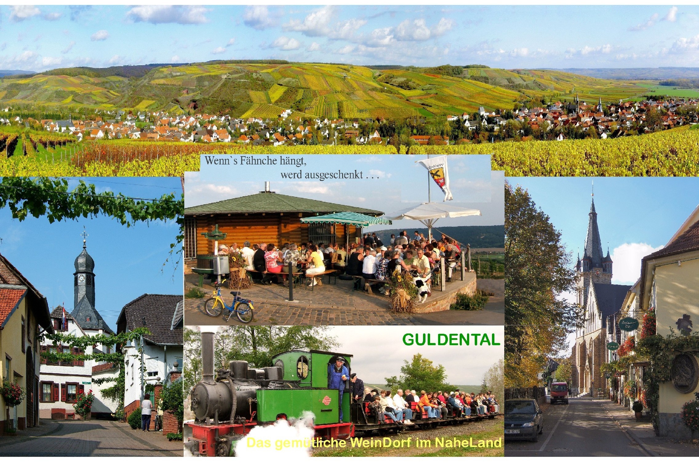
Guldental is an ''Ortsgemeinde (Germany), Ortsgemeinde'' – a Municipalities of Germany, municipality belonging to a ''Verbandsgemeinde'', a kind of collective municipality – in the Bad Kreuznach (district), Bad Kreuznach Districts of Germany, district in Rhineland-Palatinate, Germany. It belongs to the ''Verbandsgemeinde'' Langenlonsheim-Stromberg, whose seat is in Langenlonsheim. With a population of some 2,900 inhabitants, Guldental is the biggest rural winegrowing community on the Nahe (Rhine), Nahe. Geography Location Guldental lies in the Naheland – the land lining each side of the Nahe (Rhine), Nahe – among the southern foothills of the Hunsrück, on the Guldenbach. Neighbouring municipalities Clockwise from the north, Guldental's neighbours are the municipality of Langenlonsheim, the municipality of Bretzenheim, the town of Bad Kreuznach, the municipality of Hargesheim, the municipality of Gutenberg, Germany, Gutenberg and the municipality of Windesheim, ... [...More Info...] [...Related Items...] OR: [Wikipedia] [Google] [Baidu] |
Langenlonsheim
Langenlonsheim is an '' Ortsgemeinde'' – a municipality belonging to a ''Verbandsgemeinde'', a kind of collective municipality – in the Bad Kreuznach district in Rhineland-Palatinate, Germany. It belongs to the ''Verbandsgemeinde'' Langenlonsheim-Stromberg, and is also its seat. Langenlonsheim is a state-recognized tourism community and a winegrowing village. Geography Location Langenlonsheim lies between the southern edge of the Hunsrück and the Nahe. Lying 7 km away is the district seat, Bad Kreuznach, while Bingen am Rhein lies just under 10 km away. On the municipality's western outskirts, the Guldenbach flows by, while the Nahe flows by to the south. Langenlonsheim is well known for its good vineyards and wineries and its ''Qualitätsweine''. Fertile loess soils and the region's warm climate have been defining factors for the village. Neighbouring municipalities Clockwise from the north, Langenlonsheim's neighbours are the municipalities of Laubenheim, G ... [...More Info...] [...Related Items...] OR: [Wikipedia] [Google] [Baidu] |
Unzenberg
Unzenberg is an – a municipality belonging to a , a kind of collective municipality – in the Rhein-Hunsrück-Kreis (district) in Rhineland-Palatinate, Germany. It belongs to the ''Verbandsgemeinde'' of Kirchberg, whose seat is in the like-named town. Geography Location The municipality lies in the Hunsrück, in the Kauerbach valley, roughly 6 km west of Simmern and 3 km northeast of Kirchberg. Constituent communities Unzenberg's ''Ortsteile'' are Unzenberg, Göbenhausen and Tombach. History North of the village in Field 2, called “Auf dem Bitzen”, a Roman estate is believed to have once lain. Over a wide area, there have been many archaeological finds, such as one coin, bricks, roof tiles, potsherds of all sizes and thinly adorned vases of red and grey clay. Some of these finds are kept at the municipal centre and some are in private ownership. The coin is said to have been lost. Today's municipality of Unzenberg was formed out of three rural centres named ... [...More Info...] [...Related Items...] OR: [Wikipedia] [Google] [Baidu] |
Nannhausen
Nannhausen is an ''Ortsgemeinde (Germany), Ortsgemeinde'' – a Municipalities of Germany, municipality belonging to a ''Verbandsgemeinde'', a kind of collective municipality – in the Rhein-Hunsrück-Kreis (Districts of Germany, district) in Rhineland-Palatinate, Germany. It belongs to the ''Verbandsgemeinde'' Simmern-Rheinböllen, whose seat is in Simmern. Geography Location The municipality lies in the central Hunsrück at the end of the Biebertal (Bieberbach valley), roughly 3 km west of Simmern. Constituent communities Nannhausen has one outlying centre, or ''Ortsteil'', named Nickweiler, and also belonging to the municipality are the Kauerhof (farm) and the Kauermühle (mill) west of the village, and the Schmiedel to the east. History In 1399, Nannhausen had its first documentary mention in a document from Count Johann IV of County of Sponheim, Sponheim. Nannhausen belonged to the Ravengiersburg Monastery and in 1557, in the wake of the Protestant Reformation, Reforma ... [...More Info...] [...Related Items...] OR: [Wikipedia] [Google] [Baidu] |
Hirschfeld (Hunsrück)
Hirschfeld (Hunsrück) is an – a municipality belonging to a , a kind of collective municipality – in the Rhein-Hunsrück-Kreis (district) in Rhineland-Palatinate, Germany. It belongs to the ''Verbandsgemeinde'' of Kirchberg, whose seat is in the like-named town. Geography Location The municipality lies in the central Hunsrück. South of the village lies the Idarwald (forest), and to the north runs ''Bundesstraße'' 327, also known as the ''Hunsrückhöhenstraße'' (“Hunsrück Heights Road”, a scenic road across the Hunsrück built originally as a military road on Hermann Göring’s orders). A few kilometres to the northeast is Frankfurt-Hahn Airport. Hirschfeld also lies on the ''Hunsrückquerbahn'', now used along this section of the line as a tourist railway. History Bearing witness to Hirschfeld's early habitation are several barrows from prehistory and early history on the Roman road between the Belginum Archaeology Park and Boppard (''Hunsrückhöhenstraße''). ... [...More Info...] [...Related Items...] OR: [Wikipedia] [Google] [Baidu] |
Sohren
Sohren is an ''Ortsgemeinde (Germany), Ortsgemeinde'' – a Municipalities of Germany, municipality belonging to a ''Verbandsgemeinde'', a kind of collective municipality – in the Rhein-Hunsrück-Kreis (Districts of Germany, district) in Rhineland-Palatinate, Germany. It belongs to the Kirchberg (Verbandsgemeinde), ''Verbandsgemeinde'' of Kirchberg, whose seat is in the Kirchberg, Rhein-Hunsrück, like-named town. Sohren is a state-recognized tourism resort (''Fremdenverkehrsort'') and is set out in state planning as a Central place theory, lower centre. Geography Location The municipality lies in the central Hunsrück and precisely in the centre of the state of Rhineland-Palatinate. North of Sohren runs ''Bundesstraße'' 50, and northwest lies Frankfurt-Hahn Airport. Sohren lies roughly west of Kirchberg. Eight kilometres to the southwest is the edge of the Idarwald. Through the village runs the Grundbach, also known as the Dillerbach and the Sohrbach along various stretches ... [...More Info...] [...Related Items...] OR: [Wikipedia] [Google] [Baidu] |
Rheinböllen
Rheinböllen () is a town in the Rhein-Hunsrück-Kreis (district) in Rhineland-Palatinate, Germany. It belongs to the ''Verbandsgemeinde'' Simmern-Rheinböllen, whose seat is in Simmern. It was the seat of the former ''Verbandsgemeinde'' Rheinböllen. Geography Location Rheinböllen lies some 10 km as the crow flies southwest of the Middle Rhine at Bacharach in the southeast Hunsrück. The town is found in the transitional zone between (to the east) the ''Binger Wald'' (Bingen Forest) and (to the south) the Soonwald, a heavily wooded section of the west-central Hunsrück that since 2005 has belonged to the ''Naturpark Soonwald-Nahe''. Constituent communities Rheinböllen has two outlying '' Stadtteile'': Kleinweidelbach and Rheinböllerhütte. Climate Yearly precipitation in Rheinböllen amounts to 695 mm. This falls into the middle third of the precipitation chart for all Germany. Only at 39% of the German Weather Service's weather stations are lower figures reco ... [...More Info...] [...Related Items...] OR: [Wikipedia] [Google] [Baidu] |


