|
Huila Department
Huila () is one of the departments of Colombia. It is located in the southwest of the country, and its capital is Neiva. Demography and Ethnography Huila department had a population of 1,122,622 inhabitants in 2020, of which 679,667 (60.54%) live in urban areas and 442,955 (39.46%) in the rest of the ''Huilense'' territory. This amounts to 2.5% of the total Colombian population. The majority of it is settled in the Magdalena valley, the main urban centers being Neiva and Garzón, due to the possibilities offered by commercial-type agricultural economy, oil production, access to basic public services and roads connected to the central road axis along the Magdalena. The rest of the population is located on the coffee belt, standing out Pitalito and La Plata; the North Subregion is undergoing a decrease in its rural population, mainly attributable to alterations of agricultural and oil activities on the landscape. The average population density in the department is 59.88 inh ... [...More Info...] [...Related Items...] OR: [Wikipedia] [Google] [Baidu] |
Departments Of Colombia
Colombia is a unitary state, unitary republic made up of thirty-two administrative divisions referred to as departments (Spanish language, Spanish: ''departamentos'', sing. ) and one Capital District (''Capital districts and territories, Distrito Capital''). Departments are administrative division, country subdivisions and are granted a certain degree of autonomy. Each department has a governor (''gobernador'') and an Assembly (''Asamblea Departamental''), elected by popular vote for a four-year period. The governor cannot be re-elected in consecutive periods. Departments are formed by a grouping of municipalities of Colombia, municipalities (''municipios'', sing. ''municipio''). Municipal government is headed by mayor (''alcalde'') and administered by a municipal council (''concejo municipal''), both of which are elected by popular vote for four-year periods. Internal subdivisions within departments The current borders and number of the departments of Colombia was finally se ... [...More Info...] [...Related Items...] OR: [Wikipedia] [Google] [Baidu] |
List Of Colombian Departments By Human Development Index
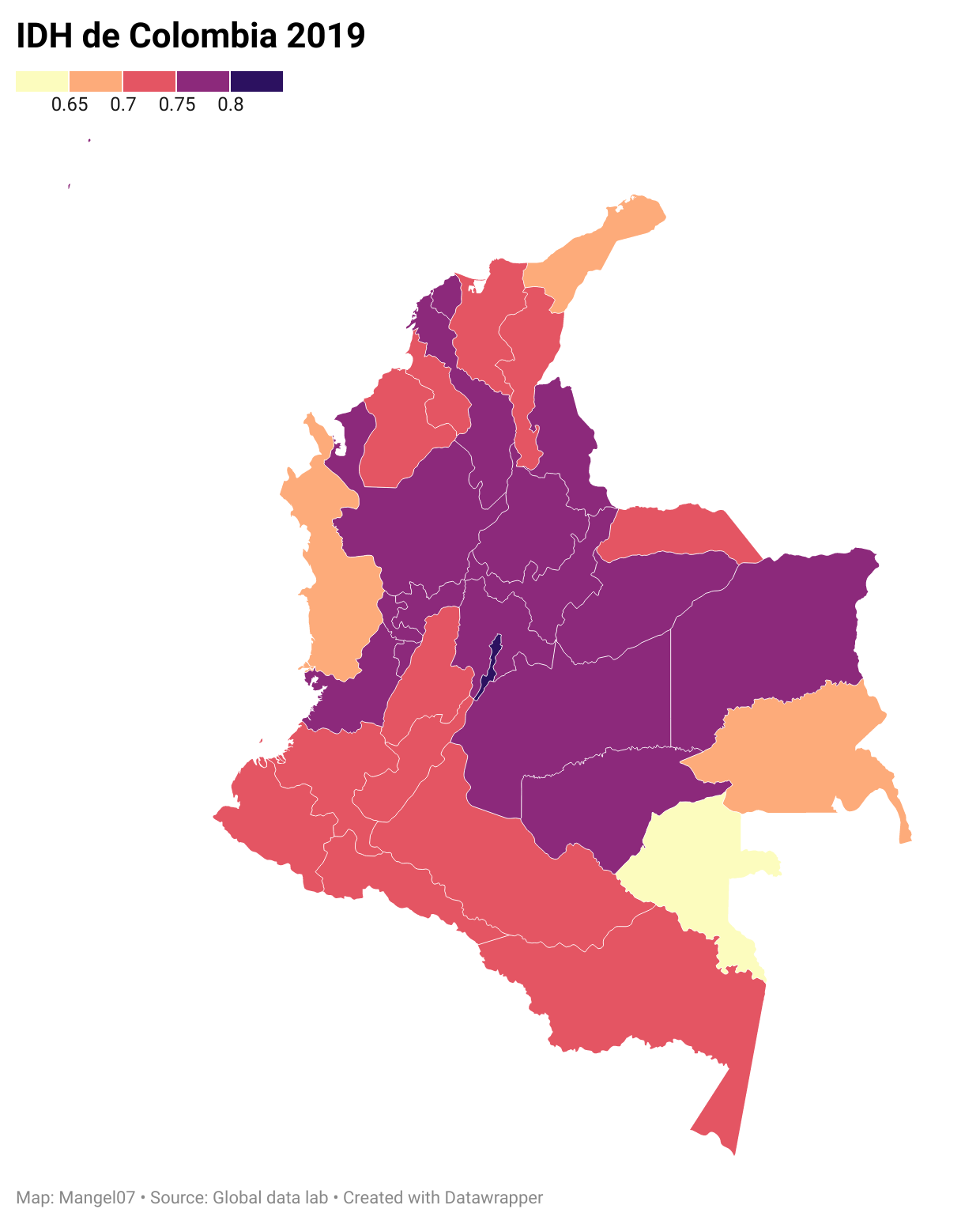
This is a list of Colombia, Colombian Departments of Colombia, departments and the capital district of Bogotá, Bogota by Human Development Index as of 2023 with data for the year 2022. See also *List of countries by Human Development Index References {{reflist Economy of Colombia-related lists, Human Development Index Human Development Index, Colombia Ranked lists of country subdivisions, Colombia ... [...More Info...] [...Related Items...] OR: [Wikipedia] [Google] [Baidu] |
Indigenous Peoples Of The Americas
In the Americas, Indigenous peoples comprise the two continents' pre-Columbian inhabitants, as well as the ethnic groups that identify with them in the 15th century, as well as the ethnic groups that identify with the pre-Columbian population of the Americas as such. These populations exhibit significant diversity; some Indigenous peoples were historically hunter-gatherers, while others practiced agriculture and aquaculture. Various Indigenous societies developed complex social structures, including pre-contact monumental architecture, organized city, cities, city-states, chiefdoms, state (polity), states, monarchy, kingdoms, republics, confederation, confederacies, and empires. These societies possessed varying levels of knowledge in fields such as Pre-Columbian engineering in the Americas, engineering, Pre-Columbian architecture, architecture, mathematics, astronomy, History of writing, writing, physics, medicine, Pre-Columbian agriculture, agriculture, irrigation, geology, minin ... [...More Info...] [...Related Items...] OR: [Wikipedia] [Google] [Baidu] |
Mestizo
( , ; fem. , literally 'mixed person') is a term primarily used to denote people of mixed European and Indigenous ancestry in the former Spanish Empire. In certain regions such as Latin America, it may also refer to people who are culturally European even though their ancestors were Indigenous American or Austronesian. The term was used as an ethno-racial exonym for mixed-race that evolved during the Spanish Empire. It was a formal label for individuals in official documents, such as censuses, parish registers, Inquisition trials, and others. Priests and royal officials might have classified persons as mestizos, but individuals also used the term in self-identification. With the Bourbon reforms and the independence of the Americas, the caste system disappeared and terms like "mestizo" fell in popularity. The noun , derived from the adjective , is a term for racial mixing that did not come into usage until the 20th century; it was not a colonial-era term.Rappaport, Joa ... [...More Info...] [...Related Items...] OR: [Wikipedia] [Google] [Baidu] |
White People
White is a Race (human categorization), racial classification of people generally used for those of predominantly Ethnic groups in Europe, European ancestry. It is also a Human skin color, skin color specifier, although the definition can vary depending on context, nationality, ethnicity and point of view. Description of populations as "White" in reference to their skin color is occasionally found in Greco-Roman ethnography and other ancient or medieval sources, but these societies did not have any notion of a White race or pan-European identity. The term "White race" or "White people", defined by their light skin among other physical characteristics, entered the major European languages in the later seventeenth century, when the concept of a "unified White" achieved greater acceptance in Europe, in the context of racialization, racialized slavery and social status in the European colonies. Scholarship on Race (human categorization), race distinguishes the modern concept from ... [...More Info...] [...Related Items...] OR: [Wikipedia] [Google] [Baidu] |
National Administrative Department Of Statistics (Colombia)
The National Administrative Department of Statistics (), commonly referred to as DANE, is the Colombian Administrative Department responsible for the planning, compilation, analysis and dissemination of the official statistics of Colombia. DANE is responsible for conducting the National Population and Housing census every ten years, among several other studies. DANE offers more than 100 statistical operations on industrial, economic, agricultural, population and quality of life aspects aimed at supporting decision-making in the country. Since 2022, the director is Beatriz Piedad Urdinola Contreras. Previous censuses * 2018 Colombian census See also * Administrative Department of Security * National Planning Department * Geographic Institute Agustín Codazzi References External links * Colombia Colombia, officially the Republic of Colombia, is a country primarily located in South America with Insular region of Colombia, insular regions in North America. Th ... [...More Info...] [...Related Items...] OR: [Wikipedia] [Google] [Baidu] |
Villavieja, Huila
Villavieja is a town and municipality in the Huila Department, Colombia. The municipality covers most of the Tatacoa Desert. The town is built on the banks of the Magdalena River The Magdalena River (, ; less commonly ) is the main river of Colombia, flowing northward about through the western half of the country. It takes its name from the biblical figure Mary Magdalene. It is navigable through much of its lower reaches, .... Climate References External links Municipalities of Huila Department {{Huila-geo-stub ... [...More Info...] [...Related Items...] OR: [Wikipedia] [Google] [Baidu] |
Colombia, Huila
Colombia is a town and municipality in the Huila Department, Colombia Colombia, officially the Republic of Colombia, is a country primarily located in South America with Insular region of Colombia, insular regions in North America. The Colombian mainland is bordered by the Caribbean Sea to the north, Venezuel .... Climate References Municipalities of Huila Department {{Huila-geo-stub ... [...More Info...] [...Related Items...] OR: [Wikipedia] [Google] [Baidu] |
La Plata, Huila
La Plata is a town and municipality in the Huila Department, Colombia, with a municipal population of 61,026 (2018 census) including the rural area, situated at an altitude of 1,050 m. It is located 122 km away from Neiva, 147 km from the city of Popayán and 210 km from the town of San Agustín. The municipality is located in the southwestern part of the department of Huila, in the foothills of the Cordillera Central, is geographically situated at coordinates 2 ° 23'00" North Latitude and 75 ° 56'00" West Longitude. The municipality is bordered on the north by the Cauca Department, on the south by the municipality of La Argentina, on the east by the municipalities of Paicol and Pital and the west by the Cauca Department. History The foundation and establishment as a municipality dates from June 5, 1651 by Captain Diego de Ospina y Maldonado, at which organizes the parish of San Sebastián de La Plata. This foundation is attributed to the passage of ... [...More Info...] [...Related Items...] OR: [Wikipedia] [Google] [Baidu] |
Pitalito
Pitalito is a Colombian town and municipality located to the south of the Department of Huila, Colombia over the Valley of the Rio Grande de la Magdalena, 188 km from Huila's capital, Neiva. It is referred to as "''The Valley of Laboyos''" and is also the second most populated municipality in the Department of Huila, with a population of 128,630. Pitalito is considered the largest producer of coffee in Colombia. Being at the epicenter of the coffee producing District of Bruselas, the town has become a notable coffee-growing area within Colombia. On several occasions, it has been awarded with the "''Cup of Excellence''", for producing the best coffee in the country. The boundaries are Timaná, Elias and Saladoblanco to the North, Palestina to the south, Isnos and San Agustín to the west, and Acevedo to the east. History On December 18, 1538, Spanish captain Pedro de Añasco founded a village in the Laboyos Valley, which was initially called Guacacallo, due to its ... [...More Info...] [...Related Items...] OR: [Wikipedia] [Google] [Baidu] |
Magdalena Department
Magdalena () is a Departments of Colombia, department of Colombia, located in the north of the country by the Caribbean Sea, with more than 1.3 million people. The capital of the Magdalena Department is Santa Marta and was named after the Magdalena River. The department inherited the name of one of the original nine states of the United States of Colombia that its current territory integrated. Geography Location The Department of Magdalena is located on the North Coast of the Colombian Caribbean Region of Colombia, Caribbean Region. On the north it borders the Caribbean Sea. On the Cardinal direction, northeast it borders the La Guajira Department, being divided by the Palomino River. On the east it borders with the Cesar Department, which is in part divided by the Guaraní River. On the west, it is divided by the Magdalena River, and it borders the departments of Atlántico Department, Atlantico in the Cardinal direction, Northwest, and Bolívar Department, Bolívar in ... [...More Info...] [...Related Items...] OR: [Wikipedia] [Google] [Baidu] |
Garzón, Huila
Garzon () is a town and municipality in the Huila Department, Colombia. Garzon is a municipality located in the center of the Colombian department of Huila, about 450 kilometers south of Bogotá and 91 kilometers south of the departmental capital, Neiva. Known as the Diocesan Capital of Huila, it is the first Catholic diocese in the region. Proud of its religious architecture and culture, Garzón is also called "the Soul of Huila." It is known for being one of the cities in the world and inside Huila where the best coffee in the world is grown and processed. This has led to the actor Hugh Jackman and his partner David Steingard to buying the coffee in Garzón for his company, foundation and coffee shop in New York called Laughing Man Foundation. History The town's first beginnings were c. 1775 on lands donated by Don Vicente Manrique de Lara. In 1783, the hamlet known as "Garzoncito" was officially founded. On January 1, 1788, it was granted the status of municipality and in ... [...More Info...] [...Related Items...] OR: [Wikipedia] [Google] [Baidu] |


