|
Horton River (Canada)
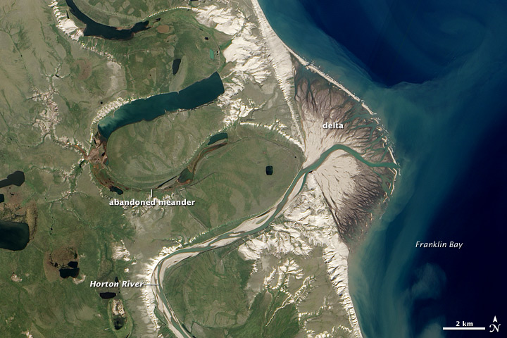
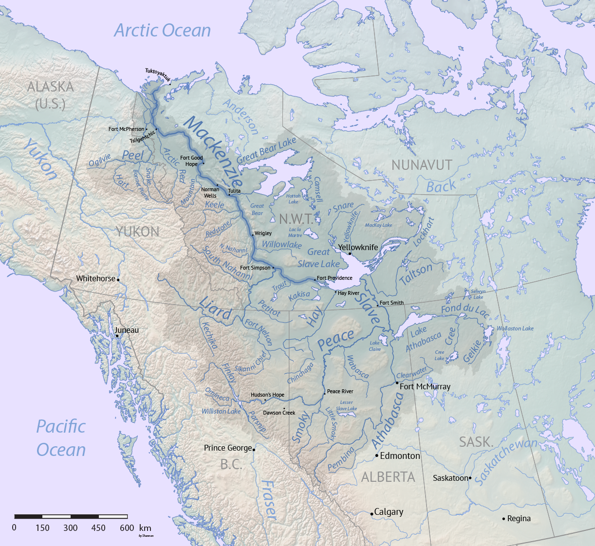
The Horton River is a river in Inuvik and Sahtu Regions, Northwest Territories and Kitikmeot Region, Nunavut, Canada. It is a tributary of the Beaufort Sea and hence part of the Arctic Ocean drainage basin. Only the first few kilometres from its source are within Nunavut. Course The river begins at a small lake about north of the northeast Dease Arm of Great Bear Lake. It passes through the Smoking Hills and reaches its mouth on the east side of Cape Bathurst at Franklin Bay on the Amundsen Gulf of the Beaufort Sea, where it forms a small delta, about northwest of the community of Paulatuk. The mouth had been further north at Harrowby Bay on the west side of Cape Bathurst until about 1800 when a meander eroded through. There is an airstrip just north of the mouth. DEW Line/NWS Located about north northwest of the rivers mouth, at , lies the Horton River Short Range Radar Site (BAR-E), also known as Malloch Hills. Originally opened as a Distant Early Warning Line site it c ... [...More Info...] [...Related Items...] OR: [Wikipedia] [Google] [Baidu] |
New South Wales
) , nickname = , image_map = New South Wales in Australia.svg , map_caption = Location of New South Wales in AustraliaCoordinates: , subdivision_type = Country , subdivision_name = Australia , established_title = Before federation , established_date = Colony of New South Wales , established_title2 = Establishment , established_date2 = 26 January 1788 , established_title3 = Responsible government , established_date3 = 6 June 1856 , established_title4 = Federation , established_date4 = 1 January 1901 , named_for = Wales , demonym = , capital = Sydney , largest_city = capital , coordinates = , admin_center = 128 local government areas , admin_center_type = Administration , leader_title1 = Monarch , leader_name1 = Charles III , leader_title2 = Governor , leader_name2 = Margaret Beazley , leader_title3 = Premier , leader_name3 = Dominic Perrottet ( Liberal) , national_representation = Parliament of Australia , national_representation_type1 = Sen ... [...More Info...] [...Related Items...] OR: [Wikipedia] [Google] [Baidu] |
Smoking Hills
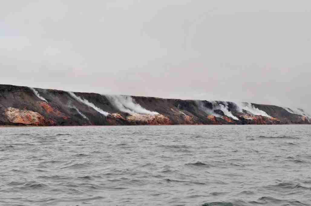
The Smoking Hills are located on the east coast of Cape Bathurst in Canada's Northwest Territories, next to the Arctic Ocean and a small group of lakes. The cliffs were named by explorer John Franklin, who was the first European to see them on his 1826 expeditions. They contain strata of hydrocarbons (oil shales), which have been burning continuously for centuries. The fires result from autoignition of sulfur-rich lignite deposits. The clouds of smoke have given the region its name. Over time the sulfur dioxide from the smoke has acidified the shallow ponds (< area and < depth) in the dotting the area, down to a pH lower than 2. Elevated concentrations of metals (aluminium, iron, zinc, nickel, manganese and cadmium) occur in these acidic ponds. Soils and sediments have also been chemically altered. ... [...More Info...] [...Related Items...] OR: [Wikipedia] [Google] [Baidu] |
Natural Resources Canada
Natural Resources Canada (NRCan; french: Ressources naturelles Canada; french: RNCan, label=none)Natural Resources Canada is the applied title under the Federal Identity Program; the legal title is Department of Natural Resources (). is the Structure of the Canadian federal government, department of the Government of Canada responsible for natural resources, energy, minerals and metals, forests, earth sciences, mapping, and remote sensing. It was formed in 1994 by amalgamating the Department of Energy, Mines and Resources with the Department of Forestry. Under the ''Constitution Act, 1867'', primary responsibility for natural resources falls to provincial governments, however, the federal government has jurisdiction over off-shore resources, trade and commerce in natural resources, statistics, international relations, and boundaries. The department administers federal legislation relating to natural resources, including energy, forests, minerals and metals. The department also co ... [...More Info...] [...Related Items...] OR: [Wikipedia] [Google] [Baidu] |
The Historica Dominion Institute
Historica Canada is a Canadian charitable organization dedicated to promoting the country's history and citizenship. All of its programs are offered bilingually and reach more than 28 million Canadians annually. A registered national charitable organization, Historica Canada was originally established as the Historica-Dominion Institute following a 2009 merger of two existing groups—the Historica Foundation of Canada and The Dominion Institute—and changed to its present name in September 2013. Anthony Wilson-Smith has been president and CEO of the organization since September 2012, with the board of directors being chaired () by First National Financial-co-founder Stephen Smith. Some of the organizations best-known programs include its collection of ''Heritage Minutes''—60-second vignettes re-enacting important and remarkable incidents in Canada's history—and ''The Canadian Encyclopedia''. Historica Canada regularly conducts public opinion polls and creates educationa ... [...More Info...] [...Related Items...] OR: [Wikipedia] [Google] [Baidu] |
The Canadian Encyclopedia
''The Canadian Encyclopedia'' (TCE; french: L'Encyclopédie canadienne) is the national encyclopedia of Canada, published online by the Toronto-based historical organization Historica Canada, with the support of Canadian Heritage. Available for free online in both English and French, ''The Canadian Encyclopedia'' includes more than 19,500 articles in both languages on numerous subjects including history, popular culture, events, people, places, politics, arts, First Nations, sports and science. The website also provides access to the ''Encyclopedia of Music in Canada'', the ''Canadian Encyclopedia Junior Edition'', ''Maclean's'' magazine articles, and ''Timelines of Canadian History''. , over 700,000 volumes of the print version of ''TCE'' have been sold and over 6 million people visit ''TCE'''s website yearly. History Background While attempts had been made to compile encyclopedic material on aspects of Canada, ''Canada: An Encyclopaedia of the Country'' (1898–1900 ... [...More Info...] [...Related Items...] OR: [Wikipedia] [Google] [Baidu] |
List Of Rivers Of The Northwest Territories
This is a list of rivers that are in whole or partly in the Northwest Territories, Canada. By watershed Arctic Ocean watershed * Back River (Nunavut) ;Canadian Arctic Archipelago * Hornaday River (Nunavut) * Kagloryuak River (Nunavut) *Nanook River (Nunavut) * Roscoe River (Nunavut) * Thomsen River ; Beaufort Sea watershed * Anderson River * Horton River (Nunavut) * Mackenzie River & watershed **Great Slave Lake watershed *** Slave River (Alberta) **** Salt River (Alberta) ***Hay River (Alberta & British Columbia) *** Yellowknife River ***Cameron River ***Taltson River *** Lockhart River ** Kakisa River (Alberta) **Horn River ** Bouvier River ** Redknife River ** Trout River ** Jean Marie River ** Spence River ** Rabbitskin River ** Liard River (Yukon & British Columbia) *** South Nahanni River (Yukon) *** Muskeg River ***Kotaneelee River (Yukon) *** Frances River ** Harris River **Martin River ** Trail River **North Nahanni River ** Root River ** Willowlake River ** River Bet ... [...More Info...] [...Related Items...] OR: [Wikipedia] [Google] [Baidu] |
List Of Longest Rivers Of Canada
Among the longest rivers of Canada are 47 streams of at least . In the case of some rivers such as the Columbia, the length listed in the table below is solely that of the main stem. In the case of others such as the Mackenzie, it is the combined lengths of the main stem and one or more upstream tributaries, as noted. Excluded from the list are rivers such as the Dauphin, a short connecting link between lakes Manitoba and Winnipeg, with main stems of or less. Also excluded are rivers such as the Mississippi, the main stems of which do not enter Canada even though some of their tributaries do. Nine rivers in this list cross international boundaries or form them. Four—the Yukon, Columbia, Porcupine, and Kootenay—begin in Canada and flow into the United States. Five—the Milk, Pend d'Oreille, Saint Lawrence, Red, and Saint John—begin in the United States and flow into Canada. Of these, the Milk and the Kootenay cross the international border twice, the ... [...More Info...] [...Related Items...] OR: [Wikipedia] [Google] [Baidu] |
North Warning System
The North Warning System (NWS) is a joint United States and Canadian early-warning radar system for the atmospheric air defense of North America. It provides surveillance of airspace from potential incursions or attacks from across North America's polar region. It replaced the Distant Early Warning Line system in the late 1980s. Overview The NWS consists of both long range AN/FPS-117 and short range AN/FPS-124 surveillance radars, operated and maintained by North American Aerospace Defense Command (NORAD). There are 13 long range sites and 36 short range sites. In Canada, the station sites are owned or leased by the Government of Canada, which also owns most of the infrastructure. The radars and tactical radios are owned by the United States Air Force. The Alaska Regional Operations Control Center (ROCC) at Elmendorf AFB, Alaska controls the stations in Alaska; the Canada East and Canada West Regional Operations Control Centres (ROCCs) at CFB North Bay, Ontario control t ... [...More Info...] [...Related Items...] OR: [Wikipedia] [Google] [Baidu] |
Distant Early Warning Line
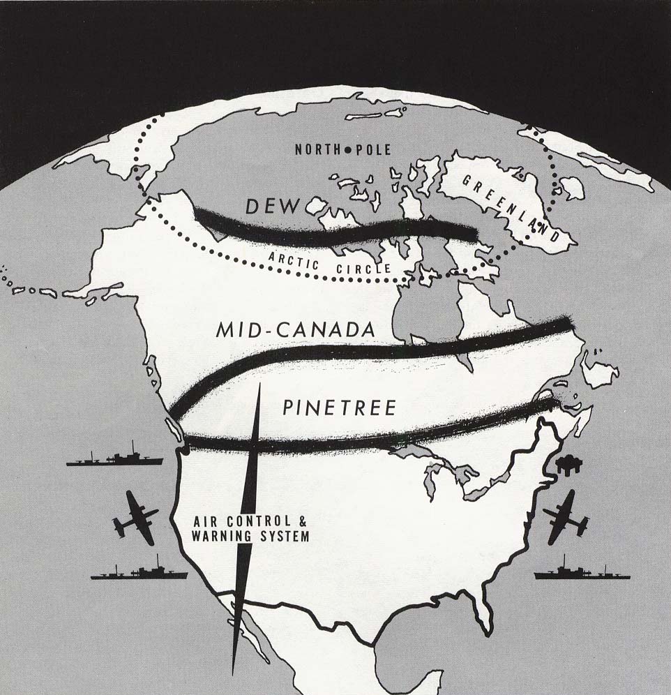
The Distant Early Warning Line, also known as the DEW Line or Early Warning Line, was a system of radar stations in the northern Arctic region of Canada, with additional stations along the north coast and Aleutian Islands of Alaska (see Project Stretchout and Project Bluegrass), in addition to the Faroe Islands, Greenland, and Iceland. It was set up to detect incoming bombers of the Soviet Union during the Cold War, and provide early warning of any sea-and-land invasion. The DEW Line was the northernmost and most capable of three radar lines in Canada and Alaska. The first of these was the joint Canadian-United States Pinetree Line, which ran from Newfoundland to Vancouver Island just north of the Canada–United States border, but even while it was being built there were concerns that it would not provide enough warning time to launch an effective counterattack. The Mid-Canada Line (MCL) was proposed as an inexpensive solution using bistatic radar. This provided a "t ... [...More Info...] [...Related Items...] OR: [Wikipedia] [Google] [Baidu] |
Airport
An airport is an aerodrome with extended facilities, mostly for commercial air transport. Airports usually consists of a landing area, which comprises an aerially accessible open space including at least one operationally active surface such as a runway for a plane to take off and to land or a helipad, and often includes adjacent utility buildings such as control towers, hangars and terminals, to maintain and monitor aircraft. Larger airports may have airport aprons, taxiway bridges, air traffic control centres, passenger facilities such as restaurants and lounges, and emergency services. In some countries, the US in particular, airports also typically have one or more fixed-base operators, serving general aviation. Operating airports is extremely complicated, with a complex system of aircraft support services, passenger services, and aircraft control services contained within the operation. Thus airports can be major employers, as well as important hubs for tou ... [...More Info...] [...Related Items...] OR: [Wikipedia] [Google] [Baidu] |
Meander
A meander is one of a series of regular sinuous curves in the channel of a river or other watercourse. It is produced as a watercourse erodes the sediments of an outer, concave bank ( cut bank) and deposits sediments on an inner, convex bank which is typically a point bar. The result of this coupled erosion and sedimentation is the formation of a sinuous course as the channel migrates back and forth across the axis of a floodplain. The zone within which a meandering stream periodically shifts its channel is known as a meander belt. It typically ranges from 15 to 18 times the width of the channel. Over time, meanders migrate downstream, sometimes in such a short time as to create civil engineering challenges for local municipalities attempting to maintain stable roads and bridges.Neuendorf, K.K.E., J.P. Mehl Jr., and J.A. Jackson, J.A., eds. (2005) ''Glossary of Geology'' (5th ed.). Alexandria, Virginia, American Geological Institute. 779 pp. Charlton, R., 2007. ''Fundamen ... [...More Info...] [...Related Items...] OR: [Wikipedia] [Google] [Baidu] |
Paulatuk
Paulatuk is a hamlet located in the Inuvik Region of the Northwest Territories, Canada. It is located adjacent to Darnley Bay, in the Amundsen Gulf. The town was named for the coal that was found in the area in the 1920s, and the Siglitun spelling is ''Paulatuuq'', "place of coal". The area has been inhabited by humans, including the Thule and Copper Inuit, since roughly 1000 CE. Most recently, it is part of the Inuvialuit Settlement Region. Paulatuk was incorporated as a hamlet in 1987 and celebrated the 50th anniversary of its settlement in 2015. Demographics In the 2021 Census of Population conducted by Statistics Canada, Paulatuk had a population of living in of its total private dwellings, a change of from its 2016 population of . With a land area of , it had a population density of in 2021. In the 2016 census 235 people were listed as Indigenous and all were Inuit (Inuvialuit). The two principal languages spoken in Paulatuk are Inuinnaqtun (Inuvialuktun) and En ... [...More Info...] [...Related Items...] OR: [Wikipedia] [Google] [Baidu] |


