|
History Of Urban Centers In The Low Countries
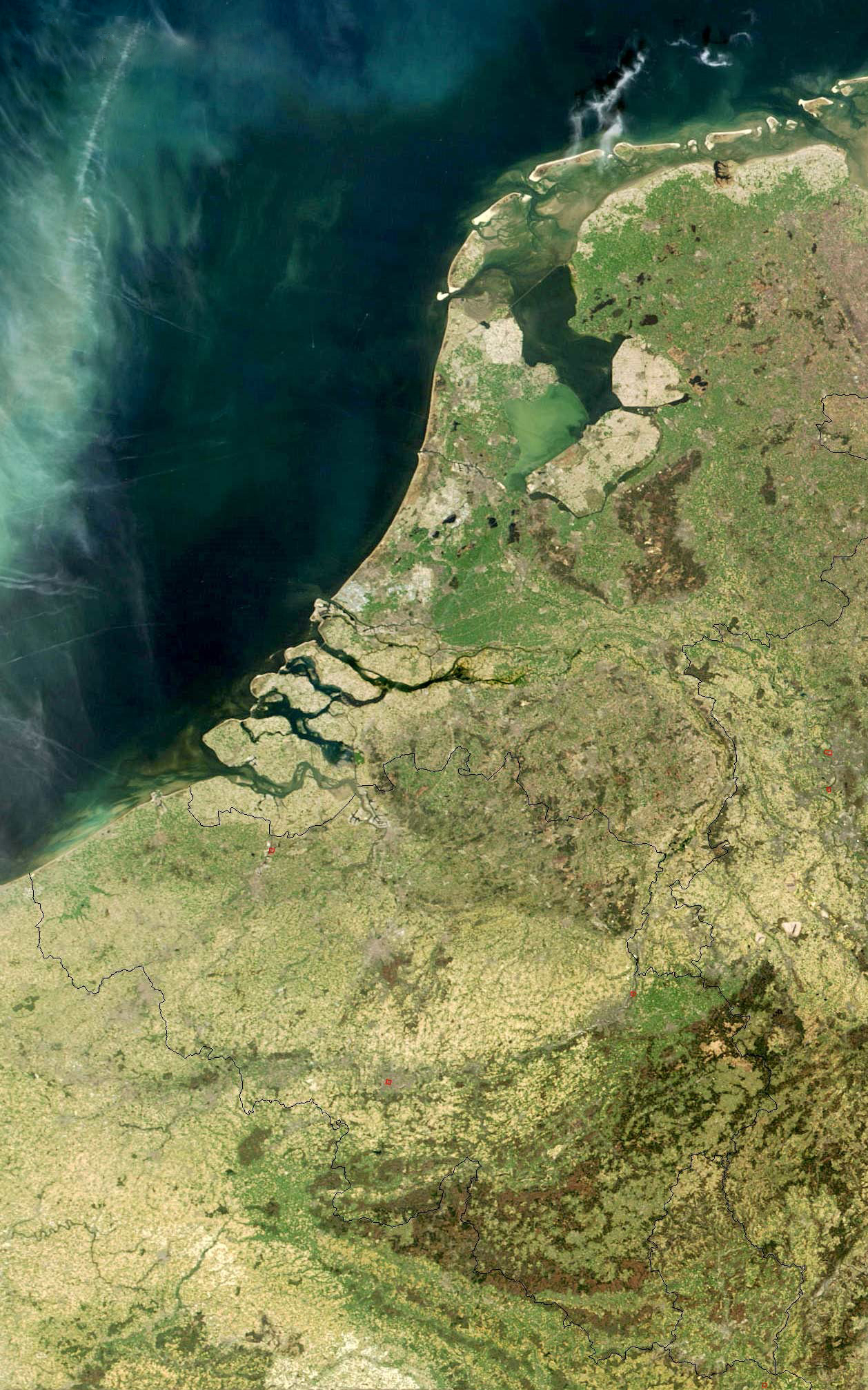
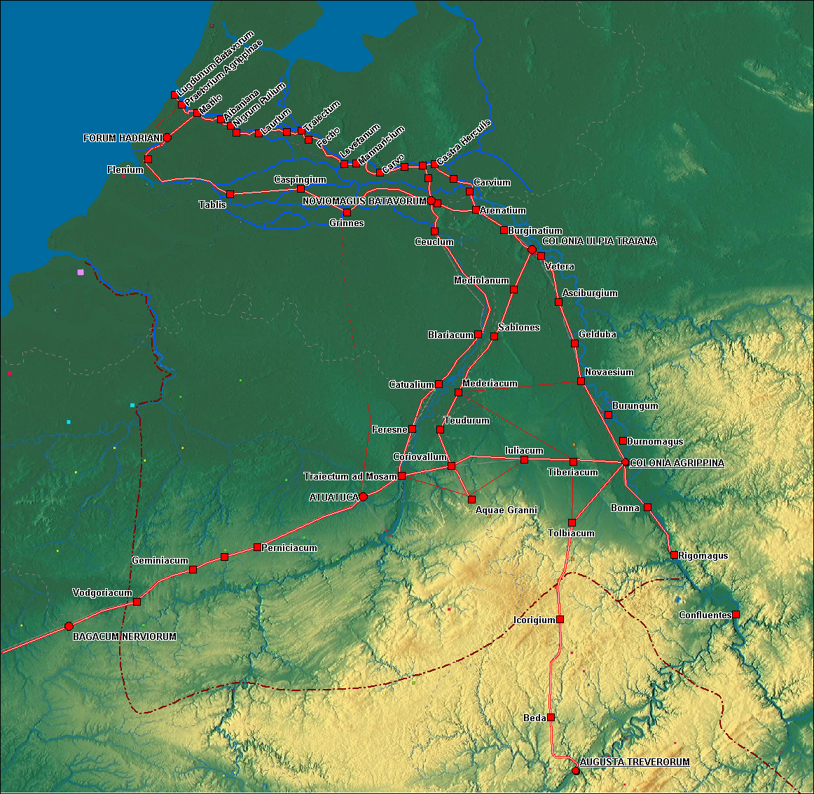
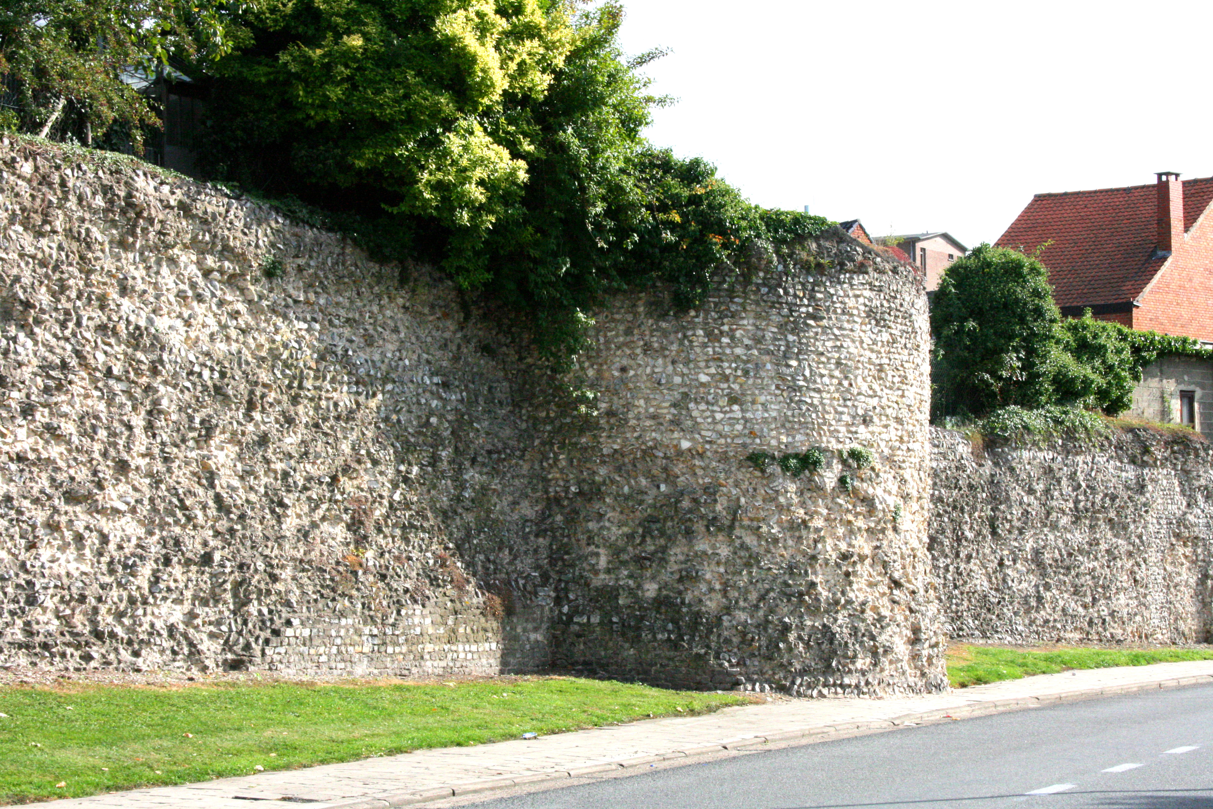
The development of urban centres in the Low Countries shows the process by which the Low Countries, a region in Western Europe, evolved from a highly rural outpost of the Roman Empire into the largest urbanised area north of the Alps by the 15th century CE. As such, this article covers the development of Dutch and Flemish cities beginning at the end of the migration period till the end of the Dutch Golden Age. Earliest settlements The northern border of the Roman Empire, known as '' limes ad Germaniam inferiorem'', was set at the Rhine in 47 AD. The border was protected with fortresses and the Low Countries became the outer provinces of the empire, situated near the Roman-Germanic border. Probably because of the (founded) fear of Germanic incursions, Roman settlements (such as Roman villas and colonies) were extremely sparse, and Roman presence was mainly limited to three Castra ( ''Noviomagus'', near modern Nijmegen; '' Flevum'', near Velsen; and one near Oudenburg, the ... [...More Info...] [...Related Items...] OR: [Wikipedia] [Google] [Baidu] |
Low Countries
The Low Countries (; ), historically also known as the Netherlands (), is a coastal lowland region in Northwestern Europe forming the lower Drainage basin, basin of the Rhine–Meuse–Scheldt delta and consisting today of the three modern "Benelux" countries: Belgium, Luxembourg, and the Netherlands (, which is singular). Geographically and historically, the area can also include parts of France (such as Nord (French department), Nord and Pas-de-Calais) and the Germany, German regions of East Frisia, Geldern, Guelders and Cleves. During the Middle Ages, the Low Countries were divided into numerous semi-independent principalities. Historically, the regions without access to the sea linked themselves politically and economically to those with access to form various unions of ports and hinterland, stretching inland as far as parts of the German Rhineland. Because of this, nowadays not only physically low-altitude areas, but also some hilly or elevated regions are considered part of ... [...More Info...] [...Related Items...] OR: [Wikipedia] [Google] [Baidu] |
Flevum
Flevum was a castrum and port of the Romans in Frisia (actual northern Netherlands), built when emperor Augustus wanted to conquer the German populated territories between the Rhine river and the Elbe river. History Two Roman fortifications (usually called ''Flevum I'' and ''Flevum II'') have been discovered at the mouth of actual North Sea Canal: the first was initially a small marching camp made by Tiberius (similar to the nearby Ermelo fortification built in 4 AD), and later enlarged to be a castrum and a port by Germanicus around 14 AD. The second was built by Caligula in 40 AD, 2 km to the northwest of the first. Both the fortifications were inside the western area of Magna Germania that was the short-lived Germania Inferior. Indeed the ruins of a Roman naval base at actual Velsen (Netherlands) are believed to be the ancient Flevum, which is listed as Phleoum, Romanized to Phleum, in Ptolemy (2.10). The first fortification was rather a simple and temporary const ... [...More Info...] [...Related Items...] OR: [Wikipedia] [Google] [Baidu] |
Herstal
Herstal (; ), formerly known as Heristal, or Héristal (), is a Municipalities of Belgium, municipality and City status in Belgium, city of Wallonia located in the Liège Province, province of Liège, Belgium. It lies along the Meuse river. Herstal is included in the "Greater Liège" urban agglomeration, agglomeration, which counts about 600,000 inhabitants. The municipality consists of the following districts: Herstal, Liers, Milmort, and Vottem. A large armaments factory, the ''FN Herstal, Fabrique Nationale'' or FN, and the biggest industrial zone of Wallonia (Haut-Sart) provide employment locally. History Merovingian and Carolingian golden age The name Herstal is of Franconian languages, Franconian origin, consisting of the elements ''hari'' ("army") and ''stal'' ("resting place", "camp"; compare Modern German ''Stall'', "stable"). The first mention of Herstal is in Latin documents from ±718 (''Cheristalius'' corrected to ''Charistalius'') and 723 (''Harastallius''). The ... [...More Info...] [...Related Items...] OR: [Wikipedia] [Google] [Baidu] |
Soissons
Soissons () is a commune in the northern French department of Aisne, in the region of Hauts-de-France. Located on the river Aisne, about northeast of Paris, it is one of the most ancient towns of France, and is probably the ancient capital of the Suessiones. Soissons is also the see of an ancient Roman Catholic diocese, whose establishment dates from about 300, and it was the location of a number of church synods called " Council of Soissons". History Soissons enters written history under its Celtic name, later borrowed into Latin, Noviodunum, meaning "new hillfort", which was the capital of the Suessiones. At Roman contact, it was a town of the Suessiones, mentioned by Julius Caesar (''B. G.'' ii. 12). Caesar (''B.C.'' 57), after leaving the Axona (modern Aisne), entered the territory of the Suessiones, and making one day's long march, reached Noviodunum, which was surrounded by a high wall and a broad ditch. The place surrendered to Caesar. From 457 to 486, under ... [...More Info...] [...Related Items...] OR: [Wikipedia] [Google] [Baidu] |
Cambrai
Cambrai (, ; ; ), formerly Cambray and historically in English Camerick or Camericke, is a city in the Nord department and in the Hauts-de-France region of France on the Scheldt river, which is known locally as the Escaut river. A sub-prefecture of the department, Cambrai is a town which had 32,501 inhabitants in 2018. It is in the heart of the urban unit of Cambrai with 46,772 inhabitants. Its functional area, a more extensive range, included 94,576 inhabitants in 2018.Comparateur de territoire: Aire d'attraction des villes 2020 de Cambrai (108), Unité urbaine 2020 de Cambrai (59403), Commune de Cambrai (59122) INSEE With |
Liège
Liège ( ; ; ; ; ) is a City status in Belgium, city and Municipalities in Belgium, municipality of Wallonia, and the capital of the Liège Province, province of Liège, Belgium. The city is situated in the valley of the Meuse, in the east of Belgium, not far from borders with the Netherlands (Maastricht is about to the north) and with Germany (Aachen is about north-east). In Liège, the Meuse meets the river Ourthe. The city is part of the ''sillon industriel'', the former industrial backbone of Wallonia. It still is the principal economic and cultural centre of the region. The municipality consists of the following Deelgemeente, sub-municipalities: Angleur, Bressoux, Chênée, Glain, Grivegnée, Jupille-sur-Meuse, Liège proper, Rocourt, Liège, Rocourt, and Wandre. In November 2012, Liège had 198,280 inhabitants. The metropolitan area, including the outer commuter zone, covers an area of 1,879 km2 (725 sq mi) and had a total population of 749,110 on 1 January 2008. ... [...More Info...] [...Related Items...] OR: [Wikipedia] [Google] [Baidu] |
Franks
file:Frankish arms.JPG, Aristocratic Frankish burial items from the Merovingian dynasty The Franks ( or ; ; ) were originally a group of Germanic peoples who lived near the Rhine river, Rhine-river military border of Germania Inferior, which was the most northerly province of the Roman Empire in continental Europe. These Frankish tribes lived for centuries under varying degrees of Roman hegemony and influence, but after the collapse of Roman institutions in western Europe they took control of a large empire including areas which had been ruled by Rome, and what it meant to be a Frank began to evolve. Once they were deeply established in Gaul, the Franks became a multilingual, Catholic Christian people, who subsequently came to rule over several other post-Roman kingdoms both inside and outside the old empire. In a broader sense much of the population of western Europe could eventually described as Franks in some contexts. The term "Frank" itself first appeared in the third cent ... [...More Info...] [...Related Items...] OR: [Wikipedia] [Google] [Baidu] |
Frisian–Frankish Wars
The Frisian–Frankish wars were a series of conflicts between the Frankish Empire and the Frisian kingdom in the 7th and 8th centuries. The wars were mainly about control of the Rhine delta. After the death of the Frisian king Redbad, the Franks gained the upper hand. In 734 at the Battle of the Boarn the Frisians were defeated and the Franks annexed the Frisian lands between the Vlie and the Lauwers. Only the Frisians east of the Lauwers remained independent. In 772 they lost their independence as well. The wars ended with the last revolt of the Frisians in 793 and the pacification of the Frisians by Charlemagne. Background The displacements of peoples during the Migration Period resulted in the Frisian settlements in the north and the west of the Low Countries, the Saxons in the east, the Warnen at the mouth of the Rhine and the Franks further south around the Scheldt. There, under the leadership of their Merovingian kings, they had an important role in the politics in ... [...More Info...] [...Related Items...] OR: [Wikipedia] [Google] [Baidu] |
Viking Age
The Viking Age (about ) was the period during the Middle Ages when Norsemen known as Vikings undertook large-scale raiding, colonising, conquest, and trading throughout Europe and reached North America. The Viking Age applies not only to their homeland of Scandinavia but also to any place significantly settled by North Germanic peoples, Scandinavians during the period. Although few of the Scandinavians of the Viking Age were Vikings in the sense of being engaged in piracy, they are often referred to as ''Vikings'' as well as ''Norsemen''. Voyaging by sea from their homelands in Denmark, Norway, and Sweden, the Norse people settled in the Viking activity in the British Isles, British Isles, History of Ireland (800–1169), Ireland, the Faroe Islands, Settlement of Iceland, Iceland, Norse settlements in Greenland, Greenland, History of Normandy, Normandy, and the Baltic Sea, Baltic coast and along the Trade route from the Varangians to the Greeks, Dnieper and Volga trade rout ... [...More Info...] [...Related Items...] OR: [Wikipedia] [Google] [Baidu] |
Dorestad
Dorestad (''Dorestat, Duristat'') was an early medieval emporium, located in the present-day province of Utrecht in the Netherlands, close to the modern-day town of Wijk bij Duurstede. It flourished during the 8th to early 9th centuries, as an important port on the northeastern shipping routes due to its proximity to the fork in the Rhine, with access to Germany via the Nederrijn (the northernmost branch of the Rhine), to the southern Netherlands, northern France, and England (via the Lek), and to the northern Netherlands, northern Germany, and Scandinavia (via the Kromme Rijn). History The township was established at the base of the former Roman fortress of ''Levefanum'' in the 7th century. The Frankish Carolingian Empire and the Frisians fought for control of the territory, until the Franks gained control of the Frisian Coast in 719. Dorestad flourished between the 7th century and the mid-9th century. The settlement was well known for minting coins under the control ... [...More Info...] [...Related Items...] OR: [Wikipedia] [Google] [Baidu] |
Tongeren
Tongeren (; ; ; ) is a city and former municipality located in the Belgian province of Limburg, in the southeastern corner of the Flemish region of Belgium. Tongeren is the oldest town in Belgium, as the only Roman administrative capital within the country's borders. As a Roman city, it was inhabited by the Tungri, and known as ''Atuatuca Tungrorum'', it was the administrative centre of the ''Civitas Tungrorum'' district. Since 1 January 2025, it is part of the new municipality Tongeren-Borgloon History ''Atuatuca Tungrorum'' The Romans referred to Tongeren as ''Aduatuca Tungrorum'' or ''Atuatuca Tongrorum'', and it was the capital of the large Roman province of '' Civitas Tungrorum'', an area which covered modern Belgian Limburg, and at least parts of all the areas around it. Before the Roman conquests, this area was inhabited by the group of Belgic tribes known as the ''Germani cisrhenani''. (Despite being known as the ''Germani'', whether they spoke a Germanic languag ... [...More Info...] [...Related Items...] OR: [Wikipedia] [Google] [Baidu] |
Utrecht
Utrecht ( ; ; ) is the List of cities in the Netherlands by province, fourth-largest city of the Netherlands, as well as the capital and the most populous city of the Provinces of the Netherlands, province of Utrecht (province), Utrecht. The municipality of Utrecht is located in the eastern part of the Randstad conurbation, in the very centre of mainland Netherlands, and includes Haarzuilens, Vleuten and De Meern. It has a population of 376,435 as of . Utrecht's ancient city centre features many buildings and structures, several dating as far back as the High Middle Ages. It has been the religious centre of the Netherlands since the 8th century. In 1579, the Union of Utrecht was signed in the city to lay the foundations for the Dutch Republic. Utrecht was the most important city in the Netherlands until the Dutch Golden Age, when it was surpassed by Amsterdam as the country's cultural centre and most populous city. Utrecht is home to Utrecht University, the largest university ... [...More Info...] [...Related Items...] OR: [Wikipedia] [Google] [Baidu] |


