|
Highway M24 (Ukraine)
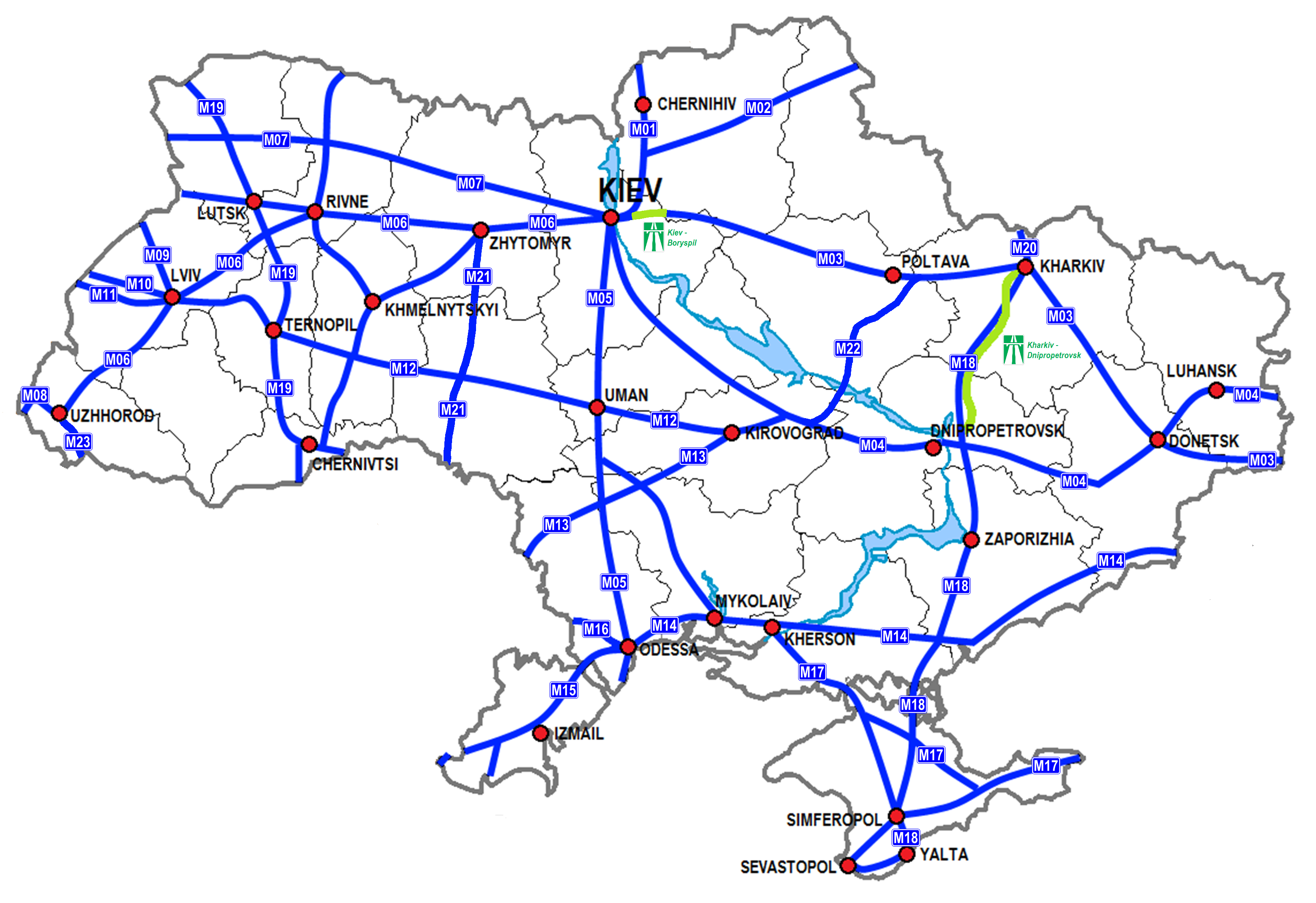
Highway M24 is a Ukrainian international highway ( M-highway) connecting the city of Mukacheve to the southern village of Astei on the border with Hungary. The route is relatively short and located entirely within Zakarpattia Oblast, Zakarpattia. Throughout most of its length on a segment between Mukacheve Mukachevo (, ; , ; see name section) is a city in Zakarpattia Oblast, western Ukraine. It is situated in the valley of the Latorica River and serves as the administrative center of Mukachevo Raion. The city is a rail terminus and highway junct ... and Berehove, it is part of European routes European route E58 and European route E81. Before 2013 it was designated as P54. Route See also * Roads in Ukraine * State Highways (Ukraine), Ukraine Highways * International E-road network * Hungary-Ukraine border References External links International Roads in Ukrainein Russian in Russian Roads in Zakarpattia Oblast {{Ukraine-road-stub ... [...More Info...] [...Related Items...] OR: [Wikipedia] [Google] [Baidu] |
Mukacheve
Mukachevo (, ; , ; see name section) is a city in Zakarpattia Oblast, western Ukraine. It is situated in the valley of the Latorica River and serves as the administrative center of Mukachevo Raion. The city is a rail terminus and highway junction, and has beer, wine, tobacco, food, textile, timber, and furniture industries. During the Cold War, it was home to Mukachevo air base and a radar station. Mukachevo lies close to the borders of four neighbouring countries: Poland, Slovakia, Hungary, and Romania. Today, the population is The city is a traditional stronghold of the Rusyn language, and the population of Mukachevo is officially reported as 77.1% ethnic Ukrainian.Ukraine Census There are also significant minorities of: |
Pavshyno
Pavshyno (, , ) is a village in Mukachevo Raion, Zakarpattia Oblast and a suburb of Mukachevo. Pavshyno is the site of a " Temporary Detention Centre" for refugees. Naming and German culture The name of the village has been transliterated variously from Cyrillic as Pawschino, Pavschino, Povshin, Pavshyn, Pawsin, Pausin, and Pausyn. All of those transliterations are/were attempts to render 'Pausching' into and out of various local languages, Pausching being the Swabian name of the village since about 1750, before which it had been known as Posahaza. To this day, the village has a German Catholic Church and about one third of population identify themselves as German. Demographics Native language according to the 2001 Ukrainian census: Military installations The site is a former military base which housed RSD-10 Pioneer (SS-20) missiles allegedly aimed at targets in Belgium. It is now managed by Military Unit 2142 of the State Border Guard Service of Ukraine. In 2002 it was tu ... [...More Info...] [...Related Items...] OR: [Wikipedia] [Google] [Baidu] |
Roads In Ukraine
Roads in Ukraine's transportation network are divided into two main categories: general-use roads, which consist of streets and roads in cities, villages, and other populated areas; and specialized roads, which include official, private, and special-use roads. Most members of the public travel on general-use roads, the most prominent of which are part of the international E-road network. However, high-speed highways, locally known as ''avtomahistrali'' (motorways) or ''shvydkisni dorohy'' (Controlled-access highway, expressways), are rare and only exist on certain segments of major routes. In early 2010, in preparation for Ukraine co-hosting the UEFA Euro 2012 football tournament, significant infrastructure improvement projects were announced by the newly-established Ministry of Infrastructure of Ukraine, then headed by Borys Kolesnikov. These efforts fell short of expectations in some areas, and the road network at-large is still in need of significant renovation. Ukraine inheri ... [...More Info...] [...Related Items...] OR: [Wikipedia] [Google] [Baidu] |
Luzhanka (border Checkpoint)
Luzhanka is a land border crossing between Ukraine and Hungary on the Ukrainian side, near the village of Astei, Berehove Raion, Zakarpattia Oblast. The crossing is situated on autoroute (). Across the border on the Hungarian side is Beregshuran checkpoint on the Szabolcs-Szatmár-Bereg County border and main road 41 in the direction of Nyíregyháza. The Luzhanka checkpoint, in addition to radiological, customs and border control, may carry out phytosanitary, veterinary, environmental and control of the International Road Transport Service. It is part of the Vynohradiv customs post at the Chop dustoms. The code of the checkpoint is 30507 16 00 (11). See also * Hungary–Ukraine border * State Border of Ukraine * Highway M24 (Ukraine) Highway M24 is a Ukrainian international highway ( M-highway) connecting the city of Mukacheve to the southern village of Astei on the border with Hungary. The route is relatively short and located entirely within Zakarpattia Oblast, Zakarpat ... [...More Info...] [...Related Items...] OR: [Wikipedia] [Google] [Baidu] |
Yanoshi
Yanoshi (, ) is a village in Zakarpattia Oblast (province) of western Ukraine. Geography The village is located around 6 km east of Berehove. Administratively, the village belongs to the Berehove Raion, Zakarpattia Oblast. History It was first mentioned as Ivanosi in 1321. Population In 1910, it had a population of 1118, mostly Hungarians Hungarians, also known as Magyars, are an Ethnicity, ethnic group native to Hungary (), who share a common Culture of Hungary, culture, Hungarian language, language and History of Hungary, history. They also have a notable presence in former pa .... According to the official census of 2001, the population included 2030 inhabitants. Villages in Berehove Raion {{Zakarpattia-geo-stub ... [...More Info...] [...Related Items...] OR: [Wikipedia] [Google] [Baidu] |
Dnepr Radar
Dnestr radar () and Dnepr radar (), both known by the NATO reporting name Hen House, are the first generation of Soviet space surveillance and early warning radars. Six radars of this type were built on the periphery of the Soviet Union starting in the 1960s to provide ballistic missile warnings for attacks from different directions. They were the primary Soviet early warning radars for much of the later Cold War. In common with other Soviet and Russian early warning radars they are named after rivers, the Dnestr and the Dnepr. The Dnestr/Dnepr radars were intended to be replaced by the newer Daryal radars starting in the 1990s. Only two of the planned Daryal radars became operational, due to issues such as the dissolution of the Soviet Union. As of 2012, the Russian early warning network still consists of some radars of this vintage. It is likely that all the existing radars will be replaced by the third generation Voronezh radars by 2020. TsSO-P The Dnestr radar came from w ... [...More Info...] [...Related Items...] OR: [Wikipedia] [Google] [Baidu] |
Mukacheve Airport
Mukachevo (, ; , ; see name section) is a city in Zakarpattia Oblast, western Ukraine. It is situated in the valley of the Latorica River and serves as the administrative center of Mukachevo Raion. The city is a rail terminus and highway junction, and has beer, wine, tobacco, food, textile, timber, and furniture industries. During the Cold War, it was home to Mukachevo air base and a radar station. Mukachevo lies close to the borders of four neighbouring countries: Poland, Slovakia, Hungary, and Romania. Today, the population is The city is a traditional stronghold of the Rusyn language, and the population of Mukachevo is officially reported as 77.1% ethnic Ukrainian.Ukraine Census There are also significant minorities of: |
Palanok Castle
The Palanok Castle or Mukachevo Castle (; or ; ) is a historic castle in the city of Mukacheve in the western Ukrainian oblast An oblast ( or ) is a type of administrative division in Bulgaria and several post-Soviet states, including Belarus, Russia and Ukraine. Historically, it was used in the Russian Empire and the Soviet Union. The term ''oblast'' is often translated i ... (Administrative divisions of Ukraine, province) of Zakarpattia Oblast, Zakarpattia. The Palanok Castle is delicately preserved,myukraine.info — Mukachevsky "Palanok" Castle and is located on a former volcano, volcanic hill. The castle complex consists of three parts: the high, middle, and low castle. [...More Info...] [...Related Items...] OR: [Wikipedia] [Google] [Baidu] |
Astei
Astei (, ) is a village (a '' selo'') in the Berehove Raion (district) of Zakarpattia Oblast in western Ukraine. It is located from the district center Berehove and is located on Highway M24. In the immediate vicinity of the village is the Luzhanka border checkpoint on the border with Hungary. History Astei was first mentioned in 1492. From the 14th to 17th centuries, the village was owned by various feudal lords. In 1566 the village, was subjected to a devastating raid by the Crimean Tatars Crimean Tatars (), or simply Crimeans (), are an Eastern European Turkic peoples, Turkic ethnic group and nation indigenous to Crimea. Their ethnogenesis lasted thousands of years in Crimea and the northern regions along the coast of the Blac .... In 1946, by decree of the Soviet Ukrainian authorities, the village of Astei was renamed Luzhanka. In 1991, its historic name was restored. References Villages in Berehove Raion {{Zakarpattia-geo-stub ... [...More Info...] [...Related Items...] OR: [Wikipedia] [Google] [Baidu] |
European Route E81
European route E 81 is a road part of the International E-road network. It begins in Constanța, Romania and ends in Mukachevo, Ukraine. The road is long. The road follows the route: Mukachevo – Halmeu – Satu Mare – Zalău – Cluj-Napoca – Turda – Sebeș – Sibiu – Pitești – București – Lehliu – Fetești – Cernavodă – Constanța. Itinerary *: Mukachevo () () (Start of concurrency with ) – Berehove *: Berehove – Vylok *: Vylok – Nevetlenfolu *: Halmeu – Livada *: Livada (End of concurrency with ) – Satu Mare *: Satu Mare () – Supuru de Sus *: Supuru de Sus – Zalău – Cluj-Napoca *: Cluj-Napoca (Start of concurrency with ) – Turda (End of concurrency with ) – Alba Iulia – Sebeș (Start of concurrency with ) – Sibiu (End of concurrency with ) *: Sibiu *: Sibiu (Start of concurrency with ) – Veștem (End of concurrency with ) *: Veștem – Râmnicu Vâlcea – Pitești *: Pitești () – Bucharest () () *: ... [...More Info...] [...Related Items...] OR: [Wikipedia] [Google] [Baidu] |
European Route E58
European route E 58 is a road part of the International E-road network. It begins in Vienna, Austria, and passing through Slovakia, Ukraine, Romania and Moldova, ends in Rostov-on-Don, Russia. It is approximately long. Since 2014, a part of the road in eastern Ukraine has been under the control of the separatist Donetsk People's Republic. During the 2022 Russian invasion of Ukraine, Russia took direct control of areas of the road in Donbas, Kherson Oblast and Zaporizhzhia Oblast. Route * **: Vienna - Fischamend - Bruck an der Leitha **: Bruck an der Leitha - / border * **: / border (Start of Concurrency with ) - Bratislava **: (Start of Concurrency with ) Bratislava - Senec - Trnava **: (End of Concurrency with ) Trnava - Nitra - Zvolen **: Zvolen - Vigľaš - Lučenec - Rimavská Sobota - Figa **: Figa - Tornaľa **: Tornaľa - Rožňava - Košice (End of Concurrency with ) **: (Start of Concurrency with ) Košice **: Košice - Michalovce - / borde ... [...More Info...] [...Related Items...] OR: [Wikipedia] [Google] [Baidu] |


