|
Hamoun Lake
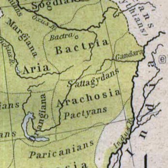
Lake Hāmūn (, ''Daryāche-ye Hāmūn''; ), or the Hamoun Oasis, is a seasonal lake and wetlands in the Endorheic basin, endorheic Sistan Basin, Sīstān Basin in the Sistan region on the Afghanistan–Iran border. In Iran, it is also known as ''Hāmūn-e Helmand'', ''Hāmūn-e Hīrmand'', or ''Daryāche-ye Sīstān'' ("Lake Sīstān"). ''Hamun, Hāmūn'' is a generic term which refers to shallow lakes (or lagoons), usually seasonal, that occur in the deserts of southeast Iran and adjacent areas of Afghanistan and Pakistan as a product of snowmelt in nearby mountains in spring. The term Hāmūn Lake (or Lake Hāmūn) equally applies to ''Hāmūn-e Helmand'' (entirely in Iran), as well to the shallow lakes Hāmūn-e Sabari and Hāmūn-e Puzak, which extend into the territory of present-day Afghanistan with the latter almost entirely inside Afghanistan. The Hamun is fed by numerous seasonal water tributaries; the main tributary is the Perennial stream, perennial Helmand River, whi ... [...More Info...] [...Related Items...] OR: [Wikipedia] [Google] [Baidu] |
Iran
Iran, officially the Islamic Republic of Iran (IRI) and also known as Persia, is a country in West Asia. It borders Iraq to the west, Turkey, Azerbaijan, and Armenia to the northwest, the Caspian Sea to the north, Turkmenistan to the northeast, Afghanistan to the east, Pakistan to the southeast, and the Gulf of Oman and the Persian Gulf to the south. With a Ethnicities in Iran, multi-ethnic population of over 92 million in an area of , Iran ranks 17th globally in both List of countries and dependencies by area, geographic size and List of countries and dependencies by population, population. It is the List of Asian countries by area, sixth-largest country entirely in Asia and one of the world's List of mountains in Iran, most mountainous countries. Officially an Islamic republic, Iran is divided into Regions of Iran, five regions with Provinces of Iran, 31 provinces. Tehran is the nation's Capital city, capital, List of cities in Iran by province, largest city and financial ... [...More Info...] [...Related Items...] OR: [Wikipedia] [Google] [Baidu] |
Basalt
Basalt (; ) is an aphanite, aphanitic (fine-grained) extrusive igneous rock formed from the rapid cooling of low-viscosity lava rich in magnesium and iron (mafic lava) exposed at or very near the planetary surface, surface of a terrestrial planet, rocky planet or natural satellite, moon. More than 90% of all volcanic rock on Earth is basalt. Rapid-cooling, fine-grained basalt is chemically equivalent to slow-cooling, coarse-grained gabbro. The eruption of basalt lava is observed by geologists at about 20 volcanoes per year. Basalt is also an important rock type on other planetary bodies in the Solar System. For example, the bulk of the plains of volcanism on Venus, Venus, which cover ~80% of the surface, are basaltic; the lunar mare, lunar maria are plains of flood-basaltic lava flows; and basalt is a common rock on the surface of Mars. Molten basalt lava has a low viscosity due to its relatively low silica content (between 45% and 52%), resulting in rapidly moving lava flo ... [...More Info...] [...Related Items...] OR: [Wikipedia] [Google] [Baidu] |
Hamun-e Helmand
Lake Hāmūn (, ''Daryāche-ye Hāmūn''; ), or the Hamoun Oasis, is a seasonal lake and wetlands in the endorheic Sīstān Basin in the Sistan region on the Afghanistan–Iran border. In Iran, it is also known as ''Hāmūn-e Helmand'', ''Hāmūn-e Hīrmand'', or ''Daryāche-ye Sīstān'' ("Lake Sīstān"). '' Hāmūn'' is a generic term which refers to shallow lakes (or lagoons), usually seasonal, that occur in the deserts of southeast Iran and adjacent areas of Afghanistan and Pakistan as a product of snowmelt in nearby mountains in spring. The term Hāmūn Lake (or Lake Hāmūn) equally applies to ''Hāmūn-e Helmand'' (entirely in Iran), as well to the shallow lakes Hāmūn-e Sabari and Hāmūn-e Puzak, which extend into the territory of present-day Afghanistan with the latter almost entirely inside Afghanistan. The Hamun is fed by numerous seasonal water tributaries; the main tributary is the perennial Helmand River, which originates in the Hindu Kush mountains in Afghanis ... [...More Info...] [...Related Items...] OR: [Wikipedia] [Google] [Baidu] |
Dahan-e Gholaman
Dahan-e Gholaman (''Dahan-i Ġulāmān'') or ''Dahaneh-e Gholaman'' is the modern name of a major Achaemenid center and archeological site in eastern Iran. It has been identified as Zranka/Zarin, the capital of the satrapy of Zranka/ Drangiana. Geography The archeological site known as Dahan-e Gholaman or Dahaneh-e Gholaman ("Gateway of the Slaves") is located some 30 km southeast of the modern city of Zabol on a neck of land separating two of the modern Chah Nimeh reservoirs, about 8.5 km from the nearest point on the Iran-Afghanistan border. Archeology Dahan-e Gholaman is the largest Achaemenid site in all of eastern Iran. Some 27 structures aligned roughly in a straight line running SW to NE along the northern edge of the site were excavated by the Italian archeologist U. Scerrato in 1962–1965 and by the Iranian archeologist S. M. S. Sajjadi in 2000–2005. Further geophysical and surface exploration in 2007–2011 revealed the outline of another monumental buildin ... [...More Info...] [...Related Items...] OR: [Wikipedia] [Google] [Baidu] |
Achaemenid Empire
The Achaemenid Empire or Achaemenian Empire, also known as the Persian Empire or First Persian Empire (; , , ), was an Iranian peoples, Iranian empire founded by Cyrus the Great of the Achaemenid dynasty in 550 BC. Based in modern-day Iran, it was the List of largest empires#Timeline of largest empires to date, largest empire by that point in history, spanning a total of . The empire spanned from the Balkans and ancient Egypt, Egypt in the west, most of West Asia, the majority of Central Asia to the northeast, and the Indus Basin, Indus Valley of South Asia to the southeast. Around the 7th century BC, the region of Persis in the southwestern portion of the Iranian plateau was settled by the Persians. From Persis, Cyrus rose and defeated the Medes, Median Empire as well as Lydia and the Neo-Babylonian Empire, marking the establishment of a new imperial polity under the Achaemenid dynasty. In the modern era, the Achaemenid Empire has been recognised for its imposition of a succ ... [...More Info...] [...Related Items...] OR: [Wikipedia] [Google] [Baidu] |
Shahr-e Sukhteh
Shahr-e Sukhteh (, meaning "Burnt City"), c. 3550–2300 BC,Ascalone, E., and P. F. Fabbri, (2022)"Demographic considerations regarding the settlement and necropolis of Shahr i Sokhta" in: E. Ascalone and S.M.S. Sajjadi (eds.), Excavations and Researches at Shahr-i Sokhta 2 (= ERSS 2), Pishin Pajouh, Tehran, pp. 524, 525. also spelled as ''Shahr-e Sūkhté'' and ''Shahr-i Sōkhta'', is an archaeological site of a sizable Bronze Age urban settlement, associated with the Helmand culture. It is located in Sistan and Baluchistan Province, the southeastern part of Iran, on the bank of the Helmand River, near the Zahedan- Zabol road. It was placed on the UNESCO World Heritage List in June 2014. The reasons for the unexpected rise and fall of the city are still wrapped in mystery. Artifacts recovered from the city demonstrate a peculiar incongruity with nearby civilizations of the time and it has been speculated that Shahr-e Sukhteh might ultimately provide concrete evidence of a c ... [...More Info...] [...Related Items...] OR: [Wikipedia] [Google] [Baidu] |
Hamoun Lake
Lake Hāmūn (, ''Daryāche-ye Hāmūn''; ), or the Hamoun Oasis, is a seasonal lake and wetlands in the Endorheic basin, endorheic Sistan Basin, Sīstān Basin in the Sistan region on the Afghanistan–Iran border. In Iran, it is also known as ''Hāmūn-e Helmand'', ''Hāmūn-e Hīrmand'', or ''Daryāche-ye Sīstān'' ("Lake Sīstān"). ''Hamun, Hāmūn'' is a generic term which refers to shallow lakes (or lagoons), usually seasonal, that occur in the deserts of southeast Iran and adjacent areas of Afghanistan and Pakistan as a product of snowmelt in nearby mountains in spring. The term Hāmūn Lake (or Lake Hāmūn) equally applies to ''Hāmūn-e Helmand'' (entirely in Iran), as well to the shallow lakes Hāmūn-e Sabari and Hāmūn-e Puzak, which extend into the territory of present-day Afghanistan with the latter almost entirely inside Afghanistan. The Hamun is fed by numerous seasonal water tributaries; the main tributary is the Perennial stream, perennial Helmand River, whi ... [...More Info...] [...Related Items...] OR: [Wikipedia] [Google] [Baidu] |
Water Politics
Water politics, sometimes called hydropolitics, is politics affected by the availability of water and water resources, a necessity for all life forms and human development. Arun P. Elhance's definition of hydropolitics is "the systematic study of conflict and cooperation between states over water resources that transcend international borders". Mollinga, P. P. classifies water politics into four categories, "the everyday politics of water resources management", "the politics of water policy in the context of sovereign states", "inter-state hydropolitics" and "the global politics of water". The availability of drinking water per capita is inadequate and shrinking worldwide. The causes, related to both quantity and quality, are many and varied; they include local scarcity, limited availability and population pressures, but also human activities of mass consumption, misuse, environmental degradation and water pollution, as well as climate change. Water is a strategic natural reso ... [...More Info...] [...Related Items...] OR: [Wikipedia] [Google] [Baidu] |
Harut River
The Harut River or Adraskan River is a river of Afghanistan which belongs to the Sistan Basin. The source of the river lies in the mountains to the southeast of Herat Herāt (; Dari/Pashto: هرات) is an oasis city and the third-largest city in Afghanistan. In 2020, it had an estimated population of 574,276, and serves as the capital of Herat Province, situated south of the Paropamisus Mountains (''Se .... The river flows for about into the Hamun Lake. Along its course are various canals for irrigation, particularly in the plains of Sabzvar and Anardarah. The Khushkek River enters the Harut. References Rivers of Afghanistan Landforms of Herat Province {{Afghanistan-river-stub ... [...More Info...] [...Related Items...] OR: [Wikipedia] [Google] [Baidu] |
Farah Province
Farah (Pashto :فرَاه /) is one of the 34 provinces of Afghanistan, located in the southwestern part of the country on the border with Iran. It is a spacious and sparsely populated province, divided into eleven Districts of Afghanistan, districts and contains hundreds of villages. It has a population of about 563,026, which is multi-ethnic and mostly a rural Pashtun tribes, tribal society. The Farah Airport is located near the city of Farah, Afghanistan, Farah, which serves as the capital of the province. Farah is linked with Iran via the Iranian border town of Mahirud. The famous tourism sites of the province include Pul Garden, New Garden, Kafee Garden, shrine of Sultan Amir and Kafer castl Geographically the province is approximately , roughly twice the size of Maryland, or half the size of South Korea. The province is bounded on the north by Herat Province, Herat, on the northeast by Ghor Province, Ghor, the southeast by Helmand Province, Helmand, the south by Nimroz Provi ... [...More Info...] [...Related Items...] OR: [Wikipedia] [Google] [Baidu] |
Lash Wa Juwayn District
Lash wa Juwayn (also transliterated Lash o Jawain) is a district in Farah Province, Afghanistan Afghanistan, officially the Islamic Emirate of Afghanistan, is a landlocked country located at the crossroads of Central Asia and South Asia. It is bordered by Pakistan to the Durand Line, east and south, Iran to the Afghanistan–Iran borde .... The main town, also called Lash wa Juwayn, is situated at 508 m elevation by Daryache-ye Sistan lake. Populated places * Tojg References External links Map of SettlementsAIMS, May 2002 Districts of Farah Province {{Farah-geo-stub ... [...More Info...] [...Related Items...] OR: [Wikipedia] [Google] [Baidu] |


