|
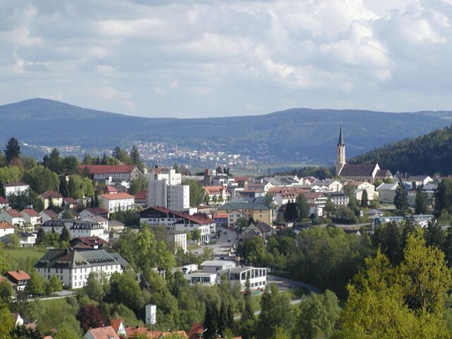
Haidmühle
Haidmühle is a municipality in the district of Freyung-Grafenau in Bavaria in Germany. Geography Geographical location The community lies in the Donau-Wald on the Kalte Moldau in the Bavarian Forest, on the border with the Czech Republic. Haidmühle is located 25 km from Freyung, 24 km from Waldkirchen, and 20 km from the border with Austria. A few meters away from the village is the border crossing Nové Údolí (''Neuthal'') to Stožec, which is open to pedestrians and cyclists. Haidmühle was formerly a railway border station, connected by the Waldkirchen–Haidmühle railway to Waldkirchen and Passau, and by the Číčenice–Haidmühle railway to Volary and Prachatice. The section in the Czech Republic is still in use. Part of the route is a museum train Pošumavská jižní dráha in operation. Constituent Communities The municipality consists of the following districts: * Auersbergsreut * Bischofsreut * Frauenberg * Haberau * Haidmühle * ... [...More Info...] [...Related Items...] OR: [Wikipedia] [Google] [Baidu] |
Waldkirchen–Haidmühle Railway
The Waldkirchen–Haidmühle railway was a branch line in Bavaria, in southern Germany. It ran from Waldkirchen to Haidmühle in the Bohemian Forest and had a junction there to the line from Haidmühle to Wallern, run by the former United Bohemian Forest Branch Line company (''Vereinigte Böhmerwald-Lokalbahnen''). It branched at Waldkirchen from the Passau – Freyung branch line (''Ilztalbahn''). The line was finally closed in 1994. History On 10 August 1904 the Bavarian state government authorised the construction of a 26.9 kilometre long branch from Waldkirchen to the Czech border beyond Haidmühle. It was not expected that the line itself would make a profit; it was built to form a junction with the Bohemian railway network. It was opened on 15 November 1910. As a result of the state treaty agreed with Austria on 22 November 1904 this branch line was given a junction with Bohemia at Haidmühle to the United Bohemian Forest Branch Line company to their branch line from Ha ... [...More Info...] [...Related Items...] OR: [Wikipedia] [Google] [Baidu] |
Volary
Volary (; german: Wallern) is a town in the South Bohemian Region of the Czech Republic. It has about 3,700 inhabitants. It is located in the Bohemian Forest, close to the border with Germany. An area in the northern part of the town with timber-framed Alpine-type buildings is well preserved and is protected by law as a village monument reservation. Administrative parts The villages of Chlum and Mlynářovice are administrative parts of Volary. Geography Volary is located about southwest of Prachatice and west of České Budějovice. It lies in the central part of the Bohemian Forest. The highest mountain in the municipal territory is Bobík at above sea level, located north of the town. Other high mountains in the territory include Jedlová (), Křemenná (), Doupná hora (), Větrný (), Mechový vrch (), and Na Skále (). The town is crossed by the Volarský creek. It flows into the Teplá Vltava, which runs along the southwestern border of the territory. History The first ... [...More Info...] [...Related Items...] OR: [Wikipedia] [Google] [Baidu] |
Freyung-Grafenau
Freyung-Grafenau is a ''Landkreis'' (district) in Bavaria, Germany. It is bounded by (from the south and clockwise) the districts of Passau, Deggendorf and Regen, the Czech Republic and by Austria. History The district was established in 1972, by merging the former districts of Grafenau and Wolfstein. In medieval times Wolfstein (east of the Ilz River) was the property of the bishop of Passau and the site of Wolfstein Castle, now a ''schloss''. Grafenau (west of the Ilz River) successively belonged to different countries, before it was annexed by Bavaria in 1438. Wolfstein became a part of Bavaria two years after the dissolution of the clerical states in Germany (1803). Geography Freyung-Grafenau is the easternmost district of Bavaria. It is located in the southern parts of the Bavarian Forest and is partially occupied by the Bavarian Forest National Park. The source of the Ilz River is situated in the district. Coat of arms The wolf represents the area of Wolfstein, while the ... [...More Info...] [...Related Items...] OR: [Wikipedia] [Google] [Baidu] |
Haidel
Haidel is a mountain in the Bavarian Forest, Bavaria, Germany Germany,, officially the Federal Republic of Germany, is a country in Central Europe. It is the second most populous country in Europe after Russia, and the most populous member state of the European Union. Germany is situated betwe .... Mountains of Bavaria Bohemian Forest Freyung-Grafenau {{FreyungGrafenau-geo-stub ... [...More Info...] [...Related Items...] OR: [Wikipedia] [Google] [Baidu] |
.jpg)

