|
Hadriacus Mons
Hadriacus Mons is an ancient, low-relief volcanic mountain on the planet Mars, located in the southern hemisphere just northeast of the impact basin Hellas and southwest of the similar volcano Tyrrhenus Mons. Hadriacus Mons is in the Hellas quadrangle. It has a diameter of . The name was approved in 2007. The flanks of Hadriacus Mons have been eroded into gullies; its southern slopes are incised by the outflow channel Dao Vallis. The large extent of volcanic deposits and the caldera size leads some researchers to suggest that these features were the result of an explosive event caused by a contact between magma and groundwater.Calderón, L.; Robertson, K.; Tovar, D. 2015Geomorphologic Evolution of the Zone of Hadriaca Patera in Mars 46th Lunar and Planetary Science Conference, 2074. ''Hadriaca Patera'', a term formerly used for the entire edifice, is now only used for the central caldera, which is in diameter. It has been suggested that lava tubes at Hadriacus Mons could p ... [...More Info...] [...Related Items...] OR: [Wikipedia] [Google] [Baidu] |
Tyrrhenus Mons
Tyrrhenus Mons, formerly Tyrrhena Mons or Tyrrhena Patera, is a large volcano in the Mare Tyrrhenum quadrangle of Mars, located at 21.36° south latitude and 253.47° west longitude. The name "Tyrrhena Patera" now refers only to the central depression, a volcanic crater or caldera. It was named after a classical albedo feature name. Pit chains are found at the summit of Tyrrhenus Mons. They are formed by collapse of material into underground voids. Since they form chains and concentric fractures that are aligned, they are probably caused by extension of the surface. Volcanic processes made the crust pull apart. Voids were formed, then material fell into them, leaving holes. It is one of the oldest volcanoes on Mars. As a consequence of its old age, Tyrrhenus Mons has many radiating gullies on its slope. When it was formed, magma may have gone through frozen ground and then erupted as easily eroded ash, instead of lava flows.Hartmann, W. 2003. A Traveler's Guide to Mars. Wo ... [...More Info...] [...Related Items...] OR: [Wikipedia] [Google] [Baidu] |
Volcanoes On Mars
Volcanic activity, or volcanism, has played a significant role in the Geology, geologic evolution of Mars. Scientists have known since the Mariner 9 mission in 1972 that volcanic features cover large portions of the Martian surface. These features include extensive lava flows, vast lava plains, and, such as Olympus Mons, the largest known volcanoes in the Solar System. Martian volcanic features range in age from Noachian (>3.7 billion years) to late Amazonian period, Amazonian (< 500 million years), indicating that the planet has been volcanically active throughout its history, and some speculate it probably still is so today. Both Mars and Earth are large, planetary differentiation, differentiated planets built from similar chondritic materials. Many of the same magmatic processes that occur on Earth also occurred on Mars, and both planets are similar enough compositiona ... [...More Info...] [...Related Items...] OR: [Wikipedia] [Google] [Baidu] |
List Of Mountains On Mars By Height
alt=four peaks, Comparison of Mount Sharp (Aeolis Mons) to three Earth peaks This is a list of all named mountains on Mars. Naming Most Martian mountains have a name including one of the following astrogeological terms: * ''Mons'' — large, isolated, mountain; may or may not be of volcanic origin. ** plural ''montes'' — mountain range. * '' Tholus'' — small dome-shaped mountain or hill. ** plural ''tholi'' — group of (usually not contiguous) small mountains. * '' Dorsum'' — long low range. Name type not present on Mars. ** plural ''dorsa'' * ''Patera'' — dish-shaped depressions on volcano peaks; not very high compared to diameter. ** plural ''paterae'' Caveats Listed are the elevations of the peaks (the vertical position relative to the areoid, which is the Martian vertical datum — the surface defined as zero elevation by average martian atmospheric pressure and planet radius), which is ''not'' the height above the surrounding terrain (topographic prominenc ... [...More Info...] [...Related Items...] OR: [Wikipedia] [Google] [Baidu] |
Ionizing Radiation
Ionizing (ionising) radiation, including Radioactive decay, nuclear radiation, consists of subatomic particles or electromagnetic waves that have enough energy per individual photon or particle to ionization, ionize atoms or molecules by detaching electrons from them. Some particles can travel up to 99% of the speed of light, and the electromagnetic waves are on the high-energy portion of the electromagnetic spectrum. Gamma rays, X-rays, and the higher energy vacuum ultraviolet, ultraviolet part of the electromagnetic spectrum are ionizing radiation; whereas the lower energy ultraviolet, visible light, infrared, microwaves, and radio waves are non-ionizing radiation. Nearly all types of laser light are non-ionizing radiation. The boundary between ionizing and non-ionizing radiation in the ultraviolet area cannot be sharply defined, as different molecules and atoms ionize at Ionization energies of the elements (data page), different energies. The energy of ionizing radiation starts ... [...More Info...] [...Related Items...] OR: [Wikipedia] [Google] [Baidu] |
Lava Tube
A lava tube, more rarely called a pyroduct, is a 'roofed conduit through which molten lava travels away from its vent'. If lava in the tube drains out, it will leave an empty cave. Lava tubes are common in low-viscosity volcanic systems. Lava tubes are important as they are able to transport molten lava much further away from the eruptive vent than lava channels. A tube-forming lava flow can emplace on longer distance due to the presence of a solid crust protecting the molten lava from atmospheric cooling. Lava tubes are often considered when preparing hazard maps or managing an eruptive crisis. Formation A lava tube is a type of lava cave formed when a low-viscosity lava flow develops a continuous and hard crust, which thickens and forms a roof above the still-flowing lava stream. Three main formation mechanisms have been described: (1) roofing over a lava channel, (2) pāhoehoe lobe extension or (3) lava flow inflation. # When it erupts from a vent, lava usually flow ... [...More Info...] [...Related Items...] OR: [Wikipedia] [Google] [Baidu] |
Hellas Quadrangle
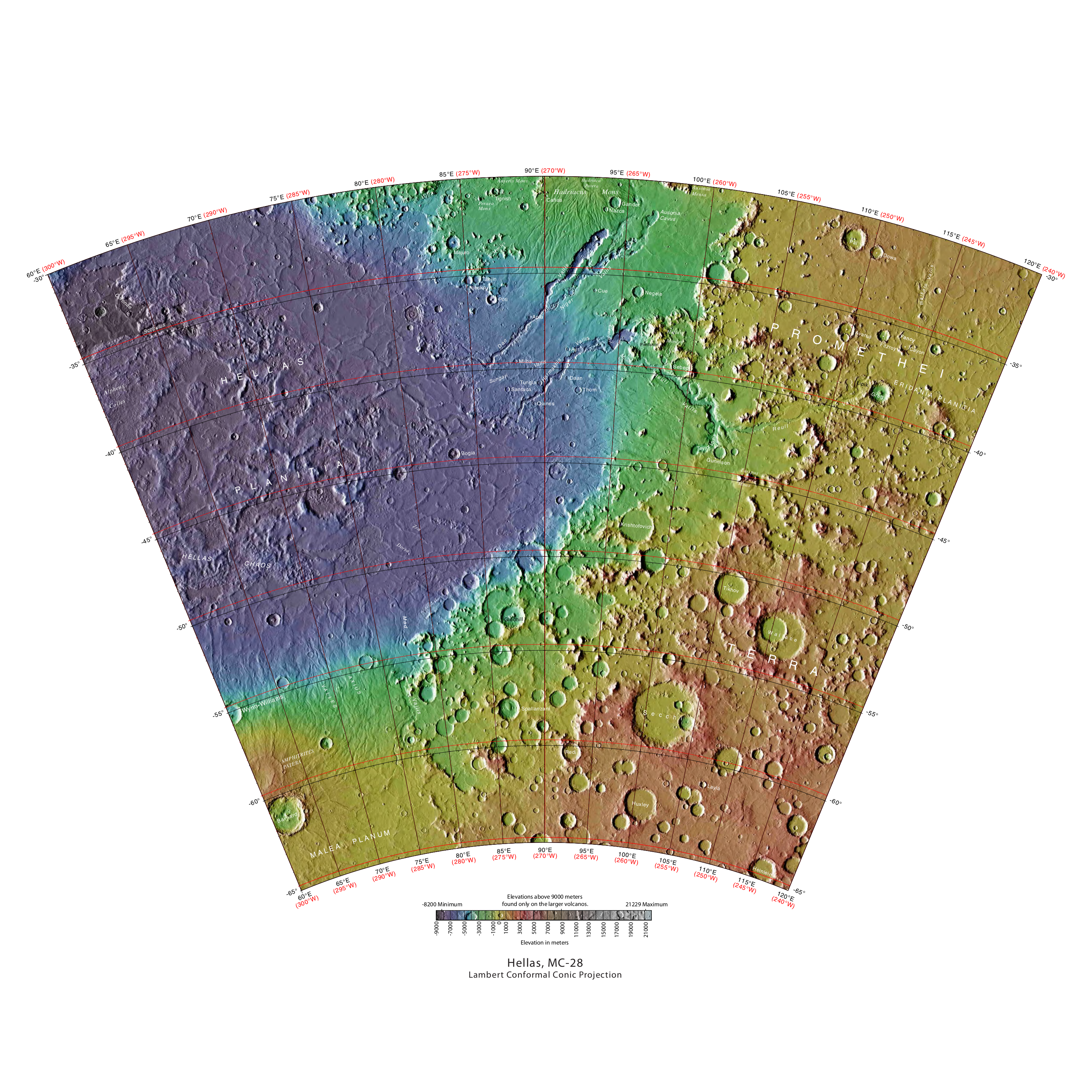
The Hellas quadrangle is one of a series of 30 quadrangle maps of Mars used by the United States Geological Survey (USGS) Astrogeology Research Program. The Hellas quadrangle is also referred to as MC-28 (Mars Chart-28). The Hellas quadrangle covers the area from 240° to 300° west longitude and 30° to 65° south latitude on the planet Mars. Within the Hellas quadrangle lies the classic features Hellas Planitia and Promethei Terra. Many interesting and mysterious features have been discovered in the Hellas quadrangle, including the giant river valleys Dao Vallis, Niger Vallis, Harmakhis, and Reull Vallis—all of which may have contributed water to a lake in the Hellas basin in the distant past. Many places in the Hellas quadrangle show signs of ice in the ground, especially places with glacier-like flow features. Hellas Basin The Hellas quadrangle contains part of the Hellas Basin, the largest known impact crater on the surface of Mars and the second largest in the Solar S ... [...More Info...] [...Related Items...] OR: [Wikipedia] [Google] [Baidu] |
Hellas Planitia
Hellas Planitia is a plain located within the huge, roughly circular impact basin Hellas located in the southern hemisphere of the planet Mars. Hellas is the fourth- or fifth-largest known impact crater in the Solar System. The basin floor is about deep, deeper than the Moon's South Pole-Aitken basin, and extends about east to west.The part below zero datum, see Geography of Mars#Zero elevation It is centered at It features the lowest point on Mars, serves as a known source of global dust storms, and may have contained lakes and glaciers. Hellas Planitia spans the boundary between the Hellas quadrangle and the Noachis quadrangle. Description With a diameter of about , it is the largest unambiguous well-exposed impact structure on the planet; the obscured Utopia Planitia is slightly larger (the Borealis Basin, if it proves to be an impact crater, is considerably larger). Hellas Planitia is thought to have been formed during the Late Heavy Bombardment period of th ... [...More Info...] [...Related Items...] OR: [Wikipedia] [Google] [Baidu] |
Thermal Emission Imaging System
The Thermal Emission Imaging System (THEMIS) is a camera on board the 2001 Mars Odyssey orbiter. It images Mars in the visible and infrared parts of the electromagnetic spectrum in order to determine the thermal properties of the surface and to refine the distribution of minerals on the surface of Mars as determined by the Thermal Emission Spectrometer (TES). Additionally, it helps scientists to understand how the mineralogy of Mars relates to its landforms, and it can be used to search for thermal hotspots in the Martian subsurface. THEMIS is managed from the Mars Space Flight Facility at Arizona State University and was built by the Santa Barbara Remote Sensing division of Raytheon, Raytheon Technologies Corporation, an American multinational corporation, multinational list of conglomerates, conglomerate headquartered in Waltham, Massachusetts. The instrument is named after Themis, the goddess of justice in ancient Greek mythology. Infrared camera THEMIS detects thermal ... [...More Info...] [...Related Items...] OR: [Wikipedia] [Google] [Baidu] |
Impact Basin
An impact crater is a depression in the surface of a solid astronomical body formed by the hypervelocity impact of a smaller object. In contrast to volcanic craters, which result from explosion or internal collapse, impact craters typically have raised rims and floors that are lower in elevation than the surrounding terrain. Impact craters are typically circular, though they can be elliptical in shape or even irregular due to events such as landslides. Impact craters range in size from microscopic craters seen on lunar rocks returned by the Apollo Program to simple bowl-shaped depressions and vast, complex, multi-ringed impact basins. Meteor Crater is a well-known example of a small impact crater on Earth. Impact craters are the dominant geographic features on many solid Solar System objects including the Moon, Mercury, Callisto, Ganymede, and most small moons and asteroids. On other planets and moons that experience more active surface geological processes, such as Earth, ... [...More Info...] [...Related Items...] OR: [Wikipedia] [Google] [Baidu] |
Mars
Mars is the fourth planet from the Sun. It is also known as the "Red Planet", because of its orange-red appearance. Mars is a desert-like rocky planet with a tenuous carbon dioxide () atmosphere. At the average surface level the atmospheric pressure is a few thousandths of Earth's, atmospheric temperature ranges from and cosmic radiation is high. Mars retains some water, in the ground as well as thinly in the atmosphere, forming cirrus clouds, frost, larger polar regions of permafrost and ice caps (with seasonal snow), but no liquid surface water. Its surface gravity is roughly a third of Earth's or double that of the Moon. It is half as wide as Earth or twice the Moon, with a diameter of , and has a surface area the size of all the dry land of Earth. Fine dust is prevalent across the surface and the atmosphere, being picked up and spread at the low Martian gravity even by the weak wind of the tenuous atmosphere. The terrain of Mars roughly follows a north-south ... [...More Info...] [...Related Items...] OR: [Wikipedia] [Google] [Baidu] |


