|
HMS Tamar (1814)
HMS ''Tamar'' was a 26-gun ''Conway''-class post-ship launched in 1814, converted into a coal hulk in 1831 at Plymouth, and sold in 1837. Josiah & Thomas Brindley launched ''Tamar'' at Frindsbury in 1814. She arrived in Halifax, after 75 men died of fever, including Captain Arthur Stowe. She was driven ashore on the coast of Labrador, British North America, in early August 1819, but later was refloated. Under the command of Captain George Richard Pechell, she captured a large pirate brig near San Domingo in 1820. She was part of the failed settlement on Melville Island at Fort Dundas in the Gulf of Carpentaria. On 3 March 1821 ''Tamar'' came into Kingston, Jamaica, with the brigantine ''Jupiter''. ''Tamar'' had detained ''Jupiter'' in the Mona Passage on 23 May after a long chase. ''Jupiter'', of eight guns and 190 men, was flying the Buenos Ayrean flag and did not surrender until ''Tamar'' had fired several shots into her that killed one man and wounded another, and that seve ... [...More Info...] [...Related Items...] OR: [Wikipedia] [Google] [Baidu] |
River Tamar
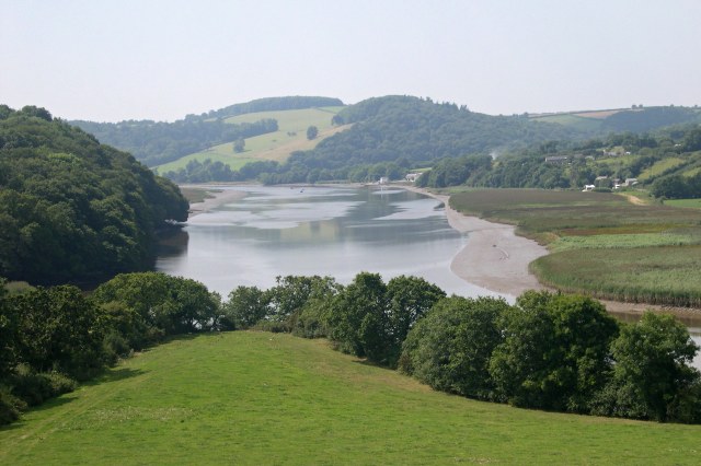
The Tamar (; kw, Dowr Tamar) is a river in south west England, that forms most of the border between Devon (to the east) and Cornwall (to the west). A part of the Tamar Valley is a World Heritage Site due to its historic mining activities. The Tamar's source is less than from the north Cornish coast, but it flows southward and its course runs across the peninsula to the south coast. The total length of the river is . At its mouth, the Tamar flows into the Hamoaze before entering Plymouth Sound, a bay of the English Channel. Tributaries of the river include the rivers Inny, Ottery, Kensey and Lynher (or ''St Germans River'') on the Cornish side, and the Deer and Tavy on the Devon side. The name Tamar (or Tamare) was mentioned by Ptolemy in the second century in his ''Geography''. The name is said to mean "great water."Furneaux, Robert. The Tamar: A Great Little River. Ex Libris Press. 1992. Foot, Sarah. ''The River Tamar''. Bossiney Books. 1989.Neale, John. Discoverin ... [...More Info...] [...Related Items...] OR: [Wikipedia] [Google] [Baidu] |
San Domingo
Hispaniola (, also ; es, La Española; Latin and french: Hispaniola; ht, Ispayola; tnq, Ayiti or Quisqueya) is an island in the Caribbean that is part of the Greater Antilles. Hispaniola is the most populous island in the West Indies, and the region's second largest in area, after the island of Cuba. The island is divided into two separate nations: the Spanish-speaking Dominican Republic (48,445 km2, 18,705 sq mi) to the east and the French/Haitian Creole-speaking Haiti (27,750 km2, 10,710 sq mi) to the west. The only other divided island in the Caribbean is Saint Martin, which is shared between France (Saint Martin) and the Netherlands ( Sint Maarten). Hispaniola is the site of one of the first European settlements in the Americas, La Navidad (1492–1493), as well as the first proper town, La Isabela (1493–1500), and the first permanent settlement, the current capital of the Dominican Republic, Santo Domingo (est. 1498). These settlements were founde ... [...More Info...] [...Related Items...] OR: [Wikipedia] [Google] [Baidu] |
Ships Built On The River Medway
A ship is a large watercraft that travels the world's oceans and other sufficiently deep waterways, carrying cargo or passengers, or in support of specialized missions, such as defense, research, and fishing. Ships are generally distinguished from boats, based on size, shape, load capacity, and purpose. Ships have supported exploration, trade, warfare, migration, colonization, and science. After the 15th century, new crops that had come from and to the Americas via the European seafarers significantly contributed to world population growth. Ship transport is responsible for the largest portion of world commerce. The word ''ship'' has meant, depending on the era and the context, either just a large vessel or specifically a ship-rigged sailing ship with three or more masts, each of which is square-rigged. As of 2016, there were more than 49,000 merchant ships, totaling almost 1.8 billion dead weight tons. Of these 28% were oil tankers, 43% were bulk carriers, and 13% were c ... [...More Info...] [...Related Items...] OR: [Wikipedia] [Google] [Baidu] |
1814 Ships
Events January * January 1 – War of the Sixth Coalition – The Royal Prussian Army led by Gebhard Leberecht von Blücher crosses the Rhine. * January 3 ** War of the Sixth Coalition – Siege of Cattaro: French garrison surrenders to the British after ten days of bombardment. ** War of the Sixth Coalition – Siege of Metz: Allied armies lay siege to the French city and fortress of Metz. * January 5 – Mexican War of Independence – Battle of Puruarán: Spanish Royalist (Spanish American independence), Royalists defeat Mexican Rebels. * January 11 – War of the Sixth Coalition – Battle of Hoogstraten: Kingdom of Prussia, Prussian forces under Friedrich Wilhelm Freiherr von Bülow defeat the French. * January 14 ** Treaty of Kiel: Frederick VI of Denmark cedes the Kingdom of Norway into Union between Sweden and Norway, personal union with Sweden, in exchange for west Pomerania. This marks the end of the real union of Denmark-Norw ... [...More Info...] [...Related Items...] OR: [Wikipedia] [Google] [Baidu] |
Plymouth
Plymouth () is a port city and unitary authority in South West England. It is located on the south coast of Devon, approximately south-west of Exeter and south-west of London. It is bordered by Cornwall to the west and south-west. Plymouth's early history extends to the Bronze Age when a first settlement emerged at Mount Batten. This settlement continued as a trading post for the Roman Empire, until it was surpassed by the more prosperous village of Sutton founded in the ninth century, now called Plymouth. In 1588, an English fleet based in Plymouth intercepted and defeated the Spanish Armada. In 1620, the Pilgrim Fathers departed Plymouth for the New World and established Plymouth Colony, the second English settlement in what is now the United States of America. During the English Civil War, the town was held by the Parliamentarians and was besieged between 1642 and 1646. Throughout the Industrial Revolution, Plymouth grew as a commercial shipping port, handling impo ... [...More Info...] [...Related Items...] OR: [Wikipedia] [Google] [Baidu] |
Lloyd's List
''Lloyd's List'' is one of the world's oldest continuously running journals, having provided weekly shipping news in London as early as 1734. It was published daily until 2013 (when the final print issue, number 60,850, was published), and is in constantly updated digital format only since then. Also known simply as ''The List'', it was begun by Edward Lloyd, the proprietor of Lloyd's Coffee House, as a reliable and concise source of information for the merchants' agents and insurance underwriters who met regularly in his establishment in Lombard Street to negotiate insurance coverage for trading vessels. The digital version, updated hour-to-hour and used internationally, continues to fulfil a similar purpose. Today it covers information, analysis and knowledge relevant to the shipping industry, including marine insurance, offshore energy, logistics, market data, research, global trade and law, in addition to shipping news. History Predecessor publications are known. One hist ... [...More Info...] [...Related Items...] OR: [Wikipedia] [Google] [Baidu] |
Barranquilla
Barranquilla () is the capital district of Atlántico Department in Colombia. It is located near the Caribbean Sea and is the largest city and third port in the Caribbean Coast region; as of 2018 it had a population of 1,206,319, making it Colombia's fourth-most populous city after Bogotá, Medellín, and Cali. Barranquilla lies strategically next to the delta of the Magdalena River, (originally before rapid urban growth) from its mouth at the Caribbean Sea, serving as a port for river and maritime transportation within Colombia. It is also the main economic center of Atlántico department in Colombia. The city is the core of the Metropolitan Area of Barranquilla, with a population of over 2 million, which also includes the municipalities of Soledad, Galapa, Malambo, and Puerto Colombia. Barranquilla was legally established as a town on April 7, 1813, although it dates from at least 1629. It grew into an important port, serving as a haven for immigrants from Europe, espe ... [...More Info...] [...Related Items...] OR: [Wikipedia] [Google] [Baidu] |
Gulf Of Carpentaria
The Gulf of Carpentaria (, ) is a large, shallow sea enclosed on three sides by northern Australia and bounded on the north by the eastern Arafura Sea (the body of water that lies between Australia and New Guinea). The northern boundary is generally defined as a line from Slade Point, Queensland (the northwestern corner of Cape York Peninsula) in the northeast, to Cape Arnhem on the Gove Peninsula, Northern Territory (the easternmost point of Arnhem Land) in the west. At its mouth, the Gulf is wide, and further south, . The north-south length exceeds . It covers a water area of about . The general depth is between and does not exceed . The tidal range in the Gulf of Carpentaria is between . The Gulf and adjacent Sahul Shelf were dry land at the peak of the last ice age 18,000 years ago when global sea level was around below its present position. At that time a large, shallow lake occupied the centre of what is now the Gulf. The Gulf hosts a submerged coral reef ... [...More Info...] [...Related Items...] OR: [Wikipedia] [Google] [Baidu] |
Fort Dundas
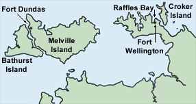
Fort Dundas was a short-lived British settlement on Melville Island between 1824 and 1828 in what is now the Northern Territory of Australia. It was the first of four British settlement attempts in northern Australia before Goyder's survey and establishment of Palmerston, now known as Darwin. The three later attempts were at Fort Wellington, Port Essington and Escape Cliffs. Establishment Captain J. J. Gordon Bremer set sail on from Port Jackson on the 24 August 1824 to colonise the northern part of Australia. His ship was accompanied by , and . The ships transported Captain Maurie Barlow, Lieutenant John Septimus Roe, Lieutenant Everard and 23 men of the 3rd Regiment, a subaltern and 26 men of the Royal Marine, a surgeon, three commissariat workers, three free men seeking adventure and 44 convicts. The construction of a settlement began upon arrival on 27 September 1824. It was officially proclaimed on 21 October 1824, on Trafalgar Day. It was named Fort Dundas and w ... [...More Info...] [...Related Items...] OR: [Wikipedia] [Google] [Baidu] |
Melville Island (Australia)
Melville Island ( Tiwi: ''Yermalner'') is an island in the eastern Timor Sea, off the coast of the Northern Territory, Australia. Along with Bathurst Island and nine smaller uninhabited islands, it forms part of the group known as the Tiwi Islands, which are under the jurisdiction of the Northern Territory in association with the Tiwi Land Council as the regional authority. History Indigenous people have occupied the area that became the Tiwi Islands for at least 40,000 years. It is said that the first European to sight the island was Abel Tasman in 1644. Explorer Phillip Parker King (son of governor of New South Wales Philip Gidley King) named it for Robert Dundas, 2nd Viscount Melville, first Lord of the Admiralty, who is also commemorated by the much larger Melville Island in the Canadian Arctic Archipelago. Shortly after this, the British made the first attempt to settle Australia's north coast, at the short-lived Fort Dundas on Melville Island. The settlement lasted fr ... [...More Info...] [...Related Items...] OR: [Wikipedia] [Google] [Baidu] |
British North America
British North America comprised the colonial territories of the British Empire in North America from 1783 onwards. English overseas possessions, English colonisation of North America began in the 16th century in Newfoundland (island), Newfoundland, then further south at Roanoke Colony, Roanoke and Jamestown, Virginia, and more substantially with the founding of the Thirteen Colonies along the Atlantic coast of North America. The British Empire's colonial territories in North America were greatly expanded in connection with the Treaty of Paris (1763), which formally concluded the Seven Years' War, referred to by the English colonies in North America as the French and Indian War, and by the French colonies as . With the ultimate acquisition of most of New France (), Territorial evolution of North America since 1763, British territory in North America was more than doubled in size, and the exclusion of France also dramatically altered the political landscape of the continent. The ... [...More Info...] [...Related Items...] OR: [Wikipedia] [Google] [Baidu] |
Frindsbury
Frindsbury is part of the Medway Towns conurbation in Kent, southern England. It lies on the opposite side of the River Medway to Rochester, and at various times in its history has been considered fully or partially part of the City of Rochester. Frindsbury today is part of the town of Strood and covers the most northern part of the town. Frindsbury refers to both a parish and a manor. Within the civil parish of Frindsbury Extra are the villages of Frindsbury, Wainscott, and Upnor. Frindsbury was also the name given to an electoral ward in the City of Rochester that straddled the parishes of Frindsbury and Strood. Topology Frindsbury lies on the northwest bank of the Medway at its lowest bridging point. After a narrow but marshy coastal strip, the land rises steeply to plateau at about . This was a sheet of chalk covered by brickearth covered with topsoil. Over the last two millennia, much of this was stripped away, or mined, so the contours have constantly changed. Through ... [...More Info...] [...Related Items...] OR: [Wikipedia] [Google] [Baidu] |


