|
Greater Nepal
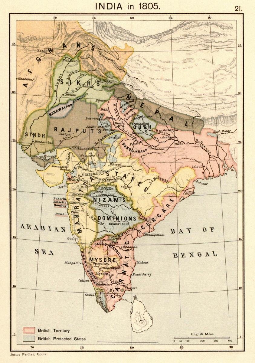
Greater Nepal is an irredentist concept in Nepal, which claims current Indian and Bangladeshi territories beyond Nepal's present-day boundaries. These claims typically include the areas controlled by Nepal between 1791 and 1816, a period that ended with the Anglo-Nepalese War and the signing of Sugauli Treaty. In addition, extensive territories in the present-day Indian states of Uttarakhand, Himanchal Pradesh, Uttar Pradesh, Bihar, West Bengal and some parts of Bangladesh are also included in the claims of the activist organisation Greater Nepal Nationalist Front, which demands the "return" of these territories to Nepal.Amy JohnsonDon’t Break the State: Indivisibility and Populist Majority Politics in Nepal Society for Cultural Anthropology, 16 March 2021. A map similar to theirs was displayed by the mayor of Kathmandu in his office in June 2023, in reaction to an alleged " Akhand Bharat" map in the Indian Parliament building. Background Nepal was originally the name of ... [...More Info...] [...Related Items...] OR: [Wikipedia] [Google] [Baidu] |
Kumaon Division
Kumaon (; , ; historically romanised as KemāonJames Prinsep (Editor)John McClelland ) is a List of divisions in India, revenue and administrative division in the Indian state of Uttarakhand. It spans over the eastern half of the state and is bounded on the north by Tibet, on the east by Nepal, on the south by the state of Uttar Pradesh, and on the west by Garhwal Division, Garhwal. Kumaon comprises six districts of the state: Almora district, Almora, Bageshwar district, Bageshwar, Champawat district, Champawat, Nainital district, Nainital, Pithoragarh district, Pithoragarh and Udham Singh Nagar district, Udham Singh Nagar. Historically known as Manaskhand and then Kurmanchal, the Kumaon region has been ruled by several dynasties over the course of history; most notably the Katyuri kings, Katyuris and the Chand kings, Chands. The Kumaon division was established in 1816, when the British reclaimed this region from the Gorkha Kingdom, Gorkhas, who had annexed the erstwhile Kumaon ... [...More Info...] [...Related Items...] OR: [Wikipedia] [Google] [Baidu] |
Sutlej
The Sutlej River or the Satluj River is a major river in Asia, flowing through China, India and Pakistan, and is the longest of the five major rivers of the Punjab region. It is also known as ''Satadru''; and is the easternmost tributary of the Indus River. The combination of the Sutlej and Chenab rivers in the plains of Punjab forms the Panjnad, which finally flows into the Indus River at Mithankot. In India, the Bhakra Dam is built around the river Sutlej to provide irrigation and other facilities to the states of Punjab, Rajasthan and Haryana. The waters of the Sutlej are allocated to India under the Indus Waters Treaty between India and Pakistan, and are mostly diverted to irrigation canals in India like the Sirhind Canal, Bhakra Main Line and the Rajasthan canal. The mean annual flow is 14 million acre feet (MAF) (roughly 1.727 × 10¹³ L) upstream of Ropar barrage, downstream of the Bhakra dam. It has several major hydroelectric points, including t ... [...More Info...] [...Related Items...] OR: [Wikipedia] [Google] [Baidu] |
Treaty Of Sugauli
The Treaty of Sugauli (also spelled Sugowlee, Sagauli and Segqulee), the treaty that established the boundary line of Nepal, was signed on 4 March 1816 between the East India Company and Guru Gajraj Mishra following the Anglo-Nepalese War of 1814–16. Background Following the Unification of Nepal under Prithvi Narayan Shah, Nepal attempted to enlarge its domains, conquering much of Sikkim in the east and, in the west, the basins of Gandaki and Karnali and the Uttarakhand regions of Garhwal and Kumaon. This brought them into conflict with the British, who controlled directly or indirectly the north Indian plains between Delhi and Calcutta. A series of campaigns termed the Anglo-Nepalese War occurred in 1814–1816. In 1815 the British general David Ochterlony evicted the Nepalese from Garhwal and Kumaon across the Kali River, ending their 12-year occupation, which is remembered for its brutality and repression. Octherlony offered peace terms to the Nepalese demandin ... [...More Info...] [...Related Items...] OR: [Wikipedia] [Google] [Baidu] |
Makwanpur
Makwanpur District (; ), in Bagmati Province, earlier a part of Narayani Zone, is one of the List of districts of Nepal, seventy-seven districts of Nepal. The city of Hetauda serves as the district headquarters and also as the provincial headquarters. The district covers an area of and had a population of 392,604 in 2001 and 420,477 in 2011. The latest census of 2021 recorded the population of Makwanpur as 466,073. History During Rana regime, the district was named Chisapani District and the headquarter of the district was situated in Chisapani Gadhi, Bhimphedi. The district renamed as Makwanpur on the name of Makwanpurgadhi and the headquarter moved to Hetauda in 1982. Geography and climate Demographics At the time of the 2011 Nepal census, Makwanpur District had a population of 420,477. As their first language, 45.8% spoke Tamang language, Tamang, 41.5% Nepali language, Nepali, 4.1% Newar language, Newari, 3.9% Chepang language, Chepang, 1.4% Magar language, Magar, 0.9% Bho ... [...More Info...] [...Related Items...] OR: [Wikipedia] [Google] [Baidu] |
Sugauli
Sugauli is a city and a notified area in East Champaran district in the Indian state of Bihar. Best known for Treaty of Sagauli, 1816 between the British and Gurkhas and role played in the Satyagraha Movement of Mahatma Gandhi Mohandas Karamchand Gandhi (2October 186930January 1948) was an Indian lawyer, anti-colonial nationalism, anti-colonial nationalist, and political ethics, political ethicist who employed nonviolent resistance to lead the successful Indian ..., it is also the setting for Rudyard Kipling's story "Rikki-Tikki-Tavi" (spelled as "Segowlee" in said story), and the place where a Sugauli Treaty, treaty was signed with Nepal in 1816. Demographics India census, Sugauli town had a population of 38,815. Sugauli is a Nagar Panchayat city in district of Purbi Champaran, Bihar. The Sugauli city is divided into 20 wards for which elections are held every 5 years. The Sugauli Nagar Panchayat has population of 38,815 of which 20,584 are males while 18,231 are fem ... [...More Info...] [...Related Items...] OR: [Wikipedia] [Google] [Baidu] |
Sharda River
The Sharda River is the downstream of Kāli River (or Mahakali River) that originates in the northern Uttarakhand state of India in the Great Himalayas on the eastern slopes of Nanda Devi massif, at an elevation of in the Pithoragarh district. It then flows between the Nepal and India border. Descending, it enters the Indo-Gangetic Plain at Brahmadev Mandi in Nepal, where it expands above the Sharda Barrage. From that point onward, it is known as the Sharda River. The river proceeds southeastward into India through northern Uttar Pradesh before merging with the Ghaghara River southwest of Bahraich, covering a distance of approximately 300 miles (480 km). It offers potential for hydroelectric power generation. The river is also proposed as source for one of the many projects in the Himalayan component of the Indian Rivers Inter-link project. Etymology and naming It is named after Śāradā, which is another name for Saraswati, the goddess of learning. It is called ... [...More Info...] [...Related Items...] OR: [Wikipedia] [Google] [Baidu] |
Unification Of Nepal
The unification of Nepal () was the process of building the modern Nepalese state, by invading fractured Malla kingdoms including the Baise Rajya's 22 kingdoms and the Chaubisi Rajya's 24 kingdoms. It began in 1743 CE (1799 BS), by Prithvi Narayan Shah, King of Gorkha. On 25 September 1768, he officially announced the creation of the Kingdom of Nepal and moved his capital from Gorkha to a city in Kathmandu Valley. The Shah dynasty that Prithvi Narayan Shah founded would go on to absorb the various warring Malla kingdoms that once occupied parts of present-day Nepal into a nation-state that stretched up to the Sutlej River in the west and Sikkim-Jalpaiguri in the east. Before the Gorkha Empire, the Kathmandu Valley was known as Nepal after the Nepal Mandala, the region's name in Newar language. Background The regions that constitute present-day Nepal were scattered as numerous independent kingdoms prior to unification. The Kathmandu Valley, then called Nepal Mandala, alon ... [...More Info...] [...Related Items...] OR: [Wikipedia] [Google] [Baidu] |
Chumbi Valley
The Chumbi Valley, called Dromo or Tromo in Tibetan, is a valley in the Himalayas that projects southwards from the Tibetan plateau, intervening between Sikkim and Bhutan. It is coextensive with the administrative unit Yadong County in the Tibet Autonomous Region of China. The Chumbi Valley is connected to Sikkim to the southwest via the mountain passes of Nathu La and Jelep La. The valley is at an altitude of , and being on the south side of the Himalayas, enjoys a wetter and more temperate climate than most of Tibet. The valley supports some vegetation in the form of the Eastern Himalayan broadleaf forests and transitions to the Eastern Himalayan alpine shrub and meadows in the north. The plant '' Pedicularis chumbica'' ( 春丕马先蒿) is named after the valley. The 1904 Younghusband Expedition of British India passed through the Chumbi Vally on its way to Lhasa. At the end of the expedition, the British took control of the Chumbi Valley in lieu of a war indemnit ... [...More Info...] [...Related Items...] OR: [Wikipedia] [Google] [Baidu] |
Teesta River
Teesta River is a long river that rises in the Pauhunri Mountain of eastern Himalayas, flows through the Indian states of Sikkim and West Bengal and subsequently enters Bangladesh through Rangpur division. In Bangladesh, it merges with Jamuna River which after meeting some other major rivers of the Bengal delta finally falls into the Bay of Bengal. It drains an area of . In India, the Teesta flows through Mangan District, Gangtok District, Pakyong District, Kalimpong district, Darjeeling District, Jalpaiguri District, Cooch Behar districts and the cities of Rangpo, Jalpaiguri and Mekhliganj. In Bangladesh, it flows through Lalmonirhat District, Rangpur District, Kurigram District and Gaibandha District. It joins the Jamuna River at Phulchhari Upazila in Bangladesh. of the river lies in India and in Bangladesh. The Teesta is the largest river of Sikkim and second largest river of West Bengal after the Ganges. Course The Teesta River originates from Teest ... [...More Info...] [...Related Items...] OR: [Wikipedia] [Google] [Baidu] |
Sikkim
Sikkim ( ; ) is a States and union territories of India, state in northeastern India. It borders the Tibet Autonomous Region of China in the north and northeast, Bhutan in the east, Koshi Province of Nepal in the west, and West Bengal in the south. Sikkim is also close to the Siliguri Corridor, which borders Bangladesh. Sikkim is the List of states and union territories of India by population, least populous and List of states and union territories of India by area, second-smallest among the Indian states. Situated in the Eastern Himalaya, Sikkim is notable for its biodiversity, including Alpine climate, alpine and subtropical climates, as well as being a host to Kangchenjunga, the List of mountains in India, highest peak in India and List of highest mountains on Earth, third-highest on Earth. Sikkim's Capital (political), capital and largest city is Gangtok. Almost 35% of the state is covered by Khangchendzonga National Park – a UNESCO World Heritage Site. The Kingdom of Si ... [...More Info...] [...Related Items...] OR: [Wikipedia] [Google] [Baidu] |


