|
Greasby
Greasby () is a large village on the Wirral Peninsula, Merseyside, England. A predominantly residential area, it is contiguous with Upton to the east and Saughall Massie to the north. The small village of Frankby is to the immediate west. Historically within the county of Cheshire, it is part of the Greasby, Frankby and Irby Ward of the Metropolitan Borough of Wirral and is in the parliamentary constituency of Wirral West. At the 2001 census, Greasby had 9,830 inhabitants, with the total population of the ward at 14,667. In the 2011 census the population of Greasby was not measured. However the total population of Greasby, Frankby and Irby Ward was 13,991. History The earliest known human settlement in Merseyside has been found at Greasby, believed to date from approximately 7000 BC. A rectangular floor of sandstone slabs and pebbles suggests regular use by the nomadic hunters of that period. The remains of burnt hazelnut shells found at the site were used for radio ... [...More Info...] [...Related Items...] OR: [Wikipedia] [Google] [Baidu] |
Frankby
Frankby () is a village on the Wirral Peninsula, in Merseyside, England. It is located between Greasby and Newton on the outskirts of the town of West Kirby. The hamlet of Larton is to the north west. Historically within the county of Cheshire, it is part of the Greasby, Frankby and Irby Ward of the Metropolitan Borough of Wirral and is in the parliamentary constituency of Wirral West. According to the 2001 census, of a total ward population of 14,667, 310 people live in Frankby. In the 2011 census, population figures specific to Frankby were not available. However, the total population of Greasby, Frankby and Irby Ward was 13,991. History The name Frankby come from the Old Norse ''Frankis-býr'', likely referring to "Frank's/Franki's ( Frenchman's) farm or settlement". Although it could also be interpreted as a personal name. The ''"býr"'' suffix, included in neighbouring place names such as Greasby, Irby and Pensby, applies to settlements believed to be Viking in ... [...More Info...] [...Related Items...] OR: [Wikipedia] [Google] [Baidu] |
Upton, Merseyside
Upton is a village in the northern part of the Wirral Peninsula, England, and is situated within of Birkenhead, of the Dee Estuary, a similar distance from the River Mersey, and from Liverpool Bay. It is in the parish of Overchurch and administratively, the village is a ward of the Metropolitan Borough of Wirral in the metropolitan county of Merseyside. Upton was in the traditional county of Cheshire. At the 2011 census, the population was 16,130. Upton was originally settled as an Anglo-Saxon farming community, and remained as a farming community until the village's rapid urbanisation and expansion from the mid-19th century. This was brought about by the development of Liverpool as a major port, with rail and road links across the Mersey estuary. The village now has a strong service economy which is based primarily around healthcare and retail, with a variety of places nearby, and within the village, to pursue sport and leisure activities. History Etymology The name Upton ... [...More Info...] [...Related Items...] OR: [Wikipedia] [Google] [Baidu] |
Wirral Peninsula
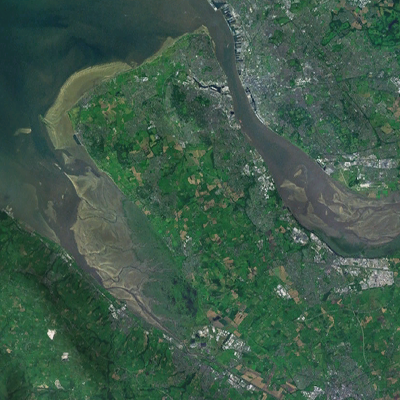
Wirral (; ), known locally as The Wirral, is a peninsula in North West England. The roughly rectangular peninsula is about long and wide and is bounded by the River Dee to the west (forming the boundary with Wales), the River Mersey to the east, and the Irish Sea to the north. Historically, the Wirral was wholly in Cheshire; in the Domesday Book, its border with the rest of the county was placed at "two arrow falls from Chester city walls". However, since the Local Government Act 1972, only the southern third has been in Cheshire, with almost all the rest lying in the Metropolitan Borough of Wirral, Merseyside. An area of saltmarsh to the south-west of the peninsula lies in the Welsh county of Flintshire. The most extensive urban development is on the eastern side of the peninsula. The Wirral contains both affluent and deprived areas, with affluent areas largely in the west, south and north of the peninsula, and deprived areas concentrated in the east, especially Birkenh ... [...More Info...] [...Related Items...] OR: [Wikipedia] [Google] [Baidu] |
Greasby, Frankby And Irby (ward)
Greasby, Frankby and Irby (previously Caldy and Frankby, 1973 to 1979, and Royden, 1979 to 2004) is a Wirral Metropolitan Borough Council Ward (politics), ward in the Wirral West (UK Parliament constituency), Wirral West Parliamentary constituency. Councillors References {{reflist Wards of Merseyside Politics of the Metropolitan Borough of Wirral Wards of the Metropolitan Borough of Wirral ... [...More Info...] [...Related Items...] OR: [Wikipedia] [Google] [Baidu] |
Saughall Massie
Saughall Massie () is a village on the Wirral Peninsula, Merseyside, England. It is part of the Moreton West & Saughall Massie Ward of the Metropolitan Borough of Wirral and the parliamentary constituency of Wallasey. A small village primarily made up of large fields owned by local farmers, it is bordered by Greasby, Meols, Moreton and Upton. At the 2001 census Saughall Massie had a population of 1,260. History The ''Saughall'' part of the name has been recorded as deriving from ''salh'' and ''halh'', meaning a place where sallows or willow shrubs grew or "Willow tree nook of land". Over the years the name has been spelt as: ''Saligh'' (1249); ''Salghale'' (1309); ''Salgham'' (1385); ''Saughoughe'' (1546). The name de Massie, de Massey or de Mascy has been connected to the Wirral since the time of the Norman Conquest. Baron Hamon de Mascey, whose family came from the settlement of Mascey near Avranches, Normandy, established Birkenhead Priory in 1150. His relations, the ... [...More Info...] [...Related Items...] OR: [Wikipedia] [Google] [Baidu] |
Wirral West (UK Parliament Constituency)
Wirral West is a constituency represented in the House of Commons of the UK Parliament by Margaret Greenwood of the Labour Party since 2015. Constituency profile The constituency is one of four covering the Metropolitan Borough of Wirral. It includes Hoylake, West Kirby, Woodchurch and the north edge of Heswall. This is one of the more affluent areas within Merseyside, reflected in higher house prices and wages than the wider North West region. History Wirral West was created in 1983 from the northern part of the former Wirral constituency, which had traditionally elected Conservative MPs. Selwyn Lloyd was the predecessor constituency's MP from 1945 to 1976, serving as Foreign Secretary during the Eden ministry, Chancellor of the Exchequer during the Macmillan ministry and becoming Speaker of the Commons in 1971. Raised to the peerage in 1976, Lloyd resigned his seat and the ensuing by-election was won by David Hunt, who became the first MP for Wirral West in ... [...More Info...] [...Related Items...] OR: [Wikipedia] [Google] [Baidu] |
Wirral Hundred
The Hundred of Wirral is the ancient administrative area for the Wirral Peninsula. Its name is believed to have originated from the ''Hundred of Wilaveston'', the historic name for Willaston, which was an important assembly point in the Wirral Hundred during the Middle Ages. The ''ton'' suffix in a place name normally indicates a previous use as a meeting location for officials. During its existence, the hundred was one of the Hundreds of Cheshire. Since local government reorganisation, implemented on 1 April 1974, the area is split between Merseyside ( Metropolitan Borough of Wirral) and Cheshire Cheshire ( ) is a ceremonial and historic county in North West England, bordered by Wales to the west, Merseyside and Greater Manchester to the north, Derbyshire to the east, and Staffordshire and Shropshire to the south. Cheshire's coun .... Villages The Hundred contained the following villages: References Metropolitan Borough of Wirral Hundreds of Cheshire ... [...More Info...] [...Related Items...] OR: [Wikipedia] [Google] [Baidu] |
Woodchurch, Merseyside
Woodchurch is an area of Birkenhead on the Wirral Peninsula, in England. Administratively, Woodchurch is within the Metropolitan Borough of Wirral, its parliamentary constituency is Wirral West, and its local council ward is Upton. At the 2001 Census, it had a population of 8,400 (3,840 males, 4,560 females). Woodchurch is dominated by a large housing development, known as the Woodchurch Estate. The district is served by several schools and has the major Arrowe Park Hospital just outside its boundary, which was built on of the park itself and opened in 1982. History Woodchurch was originally a farming area and ancient village of the Wirral Hundred, known mainly for its parish church and the neighbouring Arrowe Park country estate. The first recorded owner of the land was an Anglo-Saxon chief called Aescwulf who claimed ownership of Woodchurch, Arrowe and Landican. Although not recorded in the Domesday Book, Woodchurch was recorded as ''Wude Church'' in 1093. The populati ... [...More Info...] [...Related Items...] OR: [Wikipedia] [Google] [Baidu] |
Cheshire
Cheshire ( ) is a ceremonial and historic county in North West England, bordered by Wales to the west, Merseyside and Greater Manchester to the north, Derbyshire to the east, and Staffordshire and Shropshire to the south. Cheshire's county town is the cathedral city of Chester, while its largest town by population is Warrington. Other towns in the county include Alsager, Congleton, Crewe, Ellesmere Port, Frodsham, Knutsford, Macclesfield, Middlewich, Nantwich, Neston, Northwich, Poynton, Runcorn, Sandbach, Widnes, Wilmslow, and Winsford. Cheshire is split into the administrative districts of Cheshire West and Chester, Cheshire East, Halton, and Warrington. The county covers and has a population of around 1.1 million as of 2021. It is mostly rural, with a number of towns and villages supporting the agricultural and chemical industries; it is primarily known for producing chemicals, Cheshire cheese, salt, and silk. It has also had an impact on popular cult ... [...More Info...] [...Related Items...] OR: [Wikipedia] [Google] [Baidu] |
Thurstaston
Thurstaston is a village on the Wirral Peninsula, Merseyside, England. It is part of the West Kirby and Thurstaston Ward of the Metropolitan Borough of Wirral and the parliamentary constituency of Wirral West. The village lies on the A540 road between Heswall and Caldy, although it extends some distance down Station Road to the Wirral Way and the River Dee estuary. At the time of the 2001 census, the village itself had only 160 inhabitants, although the national census included Caldy and parts of Irby, bringing the total population to 15,548. History Thurstaston means "village of a man called Thorsteinn/Þorsteinn", from the Old Norse personal name ''Thorsteinn''/''Þorsteinn'' and Old English ''tún'' "farm, village". A record of the name as ''Torstestiune'' in 1048 proves this origin. The village was mentioned in the Domesday Book of 1086 as ''Turstanetone''. Historically and popularly, the name was wrongly thought to refer to "Thor's Stone", a sandstone outcrop on ... [...More Info...] [...Related Items...] OR: [Wikipedia] [Google] [Baidu] |
Old English
Old English (, ), or Anglo-Saxon, is the earliest recorded form of the English language, spoken in England and southern and eastern Scotland in the early Middle Ages In the history of Europe, the Middle Ages or medieval period lasted approximately from the late 5th to the late 15th centuries, similar to the post-classical period of global history. It began with the fall of the Western Roman Empire .... It was brought to Great Britain by Anglo-Saxon settlement of Britain, Anglo-Saxon settlers in the mid-5th century, and the first Old English literature, Old English literary works date from the mid-7th century. After the Norman conquest of 1066, English was replaced, for a time, by Anglo-Norman language, Anglo-Norman (a langues d'oïl, relative of French) as the language of the upper classes. This is regarded as marking the end of the Old English era, since during this period the English language was heavily influenced by Anglo-Norman, developing into a phase know ... [...More Info...] [...Related Items...] OR: [Wikipedia] [Google] [Baidu] |
.jpg)


