|
Grain, Kent
Isle of Grain (Old English ''Greon'', meaning gravel) is a village and the easternmost point of the Hoo Peninsula within the district of Medway in Kent, south-east England. Once an island and now forming part of the peninsula, the area is almost all marshland and is a major habitat for diverse wetland birds. The village constitutes a civil parish, which at the 2011 census had a population of 1,648, a net decrease of 83 people in 10 years. History Extract from the ''Topographical Dictionary of Great Britain and Ireland'' by John Gorton, 1833: "GRAINE, ISLE OF, co. Kent'' "A parish in the Hundred of Hoo, lathe of Aylesford, opposite to Sheppey at the mouth of the Thames; it is about three miles and a half long, and two and a half broad and is formed by Yantlet Creek running from the Medway to the Thames. The Creek was filled up, and had a road across it for 40 years until 1823, when the Lord Mayor ordered it to be again reopened, so as to give about eight feet navigation f ... [...More Info...] [...Related Items...] OR: [Wikipedia] [Google] [Baidu] |
Medway
Medway is a Unitary authorities of England, unitary authority area with Borough status in the United Kingdom, borough status in the ceremonial county of Kent in South East England. It was formed in 1998 by merging the boroughs of City of Rochester-upon-Medway, Rochester-upon-Medway and Gillingham, Kent, Gillingham, and is administered by Medway Council, which is independent from Kent County Council. The borough had a population of 278,016 in 2019. The borough contains the towns of Chatham, Kent, Chatham, Gillingham, Rainham, Kent, Rainham, Rochester, Kent, Rochester and Strood, which are collectively known as the Medway Towns. Medway is one of the boroughs included in the Thames Gateway development scheme. It is also the home of Universities at Medway, a tri-partite collaboration of the University of Greenwich, the University of Kent and Canterbury Christ Church University on a single campus in Chatham, together with the MidKent College, Medway School of Arts. Geography Becau ... [...More Info...] [...Related Items...] OR: [Wikipedia] [Google] [Baidu] |
Grain Fort
Grain Fort is a former artillery fort located just east of the village of Grain, Kent. It was constructed in the 1860s to defend the confluence of the Rivers Medway and Thames during a period of tension with France. The fort's location enabled its guns to support the nearby Grain Tower and Garrison Point Fort at Sheerness on the other side of the Medway. It was repeatedly altered and its guns upgraded at various points in its history, before being decommissioned in 1956 when the UK abolished its coastal defence programme. It was subsequently demolished. The remnants of the fort are still visible and have been incorporated into a coastal park. Strategic context The fort was constructed in response to a naval arms race between Britain and France. Britain's coastal defences had not been substantially upgraded since the Napoleonic Wars, but a new generation of accurate and powerful guns, mounted on fast-moving, manoeuvrable iron-clad warships, had obsoleted the existing 18th and e ... [...More Info...] [...Related Items...] OR: [Wikipedia] [Google] [Baidu] |
Antisubmarine Net
An anti-submarine net or anti-submarine boom is a boom placed across the mouth of a harbour or a strait for protection against submarines. Net laying ships would be used to place and remove the nets. The US Navy used anti-submarine nets in the Pacific War to protect major US Naval Advance Bases. Some net cutter submarines were used in the war. History Submarine nets were first used shortly after the first use of submarines in warfare, during World War I. Because they were a reaction during the war, there was not time to study the best construction methods, or the nets' overall efficacy. But this was also a benefit, because the enemy did not know how effective submarine nets were either. Testing done after the war showed that the nets used during WWI had not been effective, and yet they had acted as an effective deterrent during the war since their weaknesses were not known. A submarine net is very similar in principle to a boom. While a boom blocks a waterway for surface sh ... [...More Info...] [...Related Items...] OR: [Wikipedia] [Google] [Baidu] |
Boom (navigational Barrier)
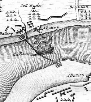
A boom or a chain (also boom defence, harbour chain, river chain, chain boom, boom chain or variants) is an obstacle strung across a navigable stretch of water to control or block navigation. They are sometimes mixed with pile barrages. In modern times they usually have civil uses, such as to prevent access to a dangerous river channel. But, especially historically, they have been used militarily, with the goal of denying access to an enemy's ships: a modern example is the anti-submarine net. Booms have also been used to force passing vessels to pay a toll. Description A boom generally floats on the surface, while a chain can be on the surface or below the water. A chain could be made to float with rafts, logs, ships or other wood, making the chain a boom as well. Historical uses Especially in medieval times, the end of a chain could be attached to a chain tower or boom tower. This allowed safe raising or lowering of the chain, as they were often heavily fortified. By raising o ... [...More Info...] [...Related Items...] OR: [Wikipedia] [Google] [Baidu] |
Fortification
A fortification (also called a fort, fortress, fastness, or stronghold) is a military construction designed for the defense of territories in warfare, and is used to establish rule in a region during peacetime. The term is derived from Latin ("strong") and ("to make"). From very early history to modern times, defensive walls have often been necessary for cities to survive in an ever-changing world of invasion and conquest. Some settlements in the Indus Valley Civilization were the first small cities to be fortified. In ancient Greece, large cyclopean stone walls fitted without mortar had been built in Mycenaean Greece, such as the ancient site of Mycenae. A Greek ''Towns of ancient Greece#Military settlements, phrourion'' was a fortified collection of buildings used as a military garrison, and is the equivalent of the ancient Roman, Roman castellum or fortress. These constructions mainly served the purpose of a watch tower, to guard certain roads, passes, and borders. Th ... [...More Info...] [...Related Items...] OR: [Wikipedia] [Google] [Baidu] |
Grain Tower
Grain Tower is a mid-19th-century gun tower situated offshore just east of Grain, Kent, standing in the mouth of the River Medway. It was built along the same lines as the Martello towers that were constructed along the British and Irish coastlines in the early 19th century and is the last-built example of a gun tower of this type. It owed its existence to the need to protect the important dockyards at Sheerness and Chatham Dockyard, Chatham from a perceived French naval threat during a period of tension in the 1850s. Rapid improvements to artillery technology in the mid-19th century meant that the tower was effectively obsolete as soon as it had been completed. A proposal to turn it into a casemated fort was dropped for being too expensive. By the end of the 19th century the tower had gained a new significance as a defence against raids by fast torpedo boats. It was used in both the First World War, First and Second World Wars, when its fabric was substantially altered to suppo ... [...More Info...] [...Related Items...] OR: [Wikipedia] [Google] [Baidu] |
Margate
Margate is a seaside resort, seaside town in the Thanet District of Kent, England. It is located on the north coast of Kent and covers an area of long, north-east of Canterbury and includes Cliftonville, Garlinge, Palm Bay, UK, Palm Bay and Westbrook, Kent, Westbrook. In 2011 it had a population of 61,223. The town has been a significant maritime port since the Middle Ages, and was associated with Dover as part of the Cinque Ports in the 15th century. It became a popular place for holidaymakers in the 18th century, owing to easy access via the Thames, and later with the arrival of the railways. Popular landmarks include the sandy beaches and the Dreamland Margate, Dreamland amusement park. During the late 20th century, the town went into decline along with other British seaside resorts, but attempts are being made to revitalise the economy. History Margate was listed in the Domesday Book of 1086 as lying within the hundred of Thanet and the county of Kent. Margate was rec ... [...More Info...] [...Related Items...] OR: [Wikipedia] [Google] [Baidu] |
Port Of London Authority
The Port of London Authority (PLA) is a self-funding public trust established on 31 March 1909 in accordance with the Port of London Act 1908 to govern the Port of London. Its responsibility extends over the Tideway of the River Thames and its continuation (the Kent/Essex strait). It maintains and supervises navigation, and protects the river's environment. The PLA originally operated all Port of London#Enclosed dock systems, enclosed dock systems on the river (except the Regent's Canal Dock), but these have long been closed to commercial traffic, with the exception of Port of Tilbury, which was privatised in 1992. It inherited the private police forces of the companies which had previously run the docks, reorganising them into a single Port of London Authority Police. Finance The PLA receives no funding from the government and is entirely self-financing. Revenues are raised from conservancy charges on vessels and cargo, pilotage charges, annual port dues, hydrographic servic ... [...More Info...] [...Related Items...] OR: [Wikipedia] [Google] [Baidu] |
London Stone (riparian)
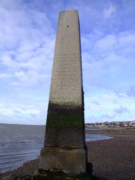
London Stone is the name given to a number of Boundary marker, boundary stones that stand beside the rivers River Thames, Thames and River Medway, Medway, which formerly marked the limits of jurisdiction (riparian water rights) of the City of London. History Until 1350, The Crown, the English Crown held the right to fish the rivers of England and charged Duty (economics), duties on those people it licensed to fish. In 1197 Richard I of England, King Richard I, in need of money to finance his involvement in the Third Crusade, sold the rights over the lower reaches of the River Thames to the City of London. Marker stones were erected to indicate the limit of the City's rights. In Victorian era, Victorian times, the Lord Mayor of the City of London, Lord Mayor would come in procession by water and touch the Staines-upon-Thames, Staines stone with a sword to re-affirm the City's rights. Control of the river passed from the City to the Thames Conservancy, and then below Teddington ... [...More Info...] [...Related Items...] OR: [Wikipedia] [Google] [Baidu] |


