|
Gosford Forest Park
Gosford Forest Park is a forest park located outside Markethill, County Armagh, Northern Ireland. The park, previously Gosford Demesne, was acquired by the Department of Agriculture in 1958 and comprises some 240 hectares of diverse woodland and open parkland. Gosford Forest Park is also home to Gosford Castle. It was designated the first conservation forest in Northern Ireland in 1986. Facilities Facilities available include: * Camping and Caravanning Site (with mains electricity) * Picnic and Barbecue areas * Tea House and Shop * Way-marked Trails * Horse-riding routes * Orienteering routes * Disabled facilities * Bookable Guided Tours * Special events (arranged by permit) * Function Hall History In the early 17th century the Acheson family came to the Markethill area, and built a very substantial farmhouse near the present town of Markethill. The family came from Monmouthshire and, in fact, the present Earl of Weymes is related to the Achesons who later became the Earls ... [...More Info...] [...Related Items...] OR: [Wikipedia] [Google] [Baidu] |
Markethill
Markethill () is a village in County Armagh, Northern Ireland. It is beside Gosford Forest Park. It had a population of 1,647 people in the 2011 Census. This article contains quotations from this source, which is available under th Open Government Licence v3.0. © Crown copyright. A livestock market is held here three times a week and each summer the world's largest Lambeg drumming contest takes place in the village. It is home to Kilcluney Volunteers Flute Band, who host the largest band parade in Europe on the first Friday of each June. History The village sprang up within the townland of Coolmallish or Coolmillish ( gle, Cúil Mheallghuis), on the road between Armagh and Newry. It began to grow during the Plantation of Ulster as a town for Scottish and English migrants. The Troubles During the Troubles, there were a number of incidents in Markethill, including a number which resulted in fatalities. *On 24 June 1979 an off-duty UDR soldier was shot dead by the IRA while ... [...More Info...] [...Related Items...] OR: [Wikipedia] [Google] [Baidu] |
County Armagh
County Armagh (, named after its county town, Armagh) is one of the six counties of Northern Ireland and one of the traditional thirty-two counties of Ireland. Adjoined to the southern shore of Lough Neagh, the county covers an area of and has a population of about 175,000. County Armagh is known as the "Orchard County" because of its many apple orchards. The county is part of the provinces of Ireland, historic province of Ulster. Etymology The name "Armagh" derives from the Irish word ' meaning "height" (or high place) and '. is mentioned in ''Lebor Gabála Érenn, The Book of the Taking of Ireland'', and is also said to have been responsible for the construction of the hill site of (now Navan Fort near Armagh, Armagh City) to serve as the capital of the kings (who give their name to Ulster), also thought to be 's ''height''. Geography and features From its highest point at Slieve Gullion, in the south of the county, Armagh's land falls away from its rugged south with Carr ... [...More Info...] [...Related Items...] OR: [Wikipedia] [Google] [Baidu] |
Northern Ireland
Northern Ireland ( ga, Tuaisceart Éireann ; sco, label=Ulster-Scots, Norlin Airlann) is a part of the United Kingdom, situated in the north-east of the island of Ireland, that is variously described as a country, province or region. Northern Ireland shares an open border to the south and west with the Republic of Ireland. In 2021, its population was 1,903,100, making up about 27% of Ireland's population and about 3% of the UK's population. The Northern Ireland Assembly (colloquially referred to as Stormont after its location), established by the Northern Ireland Act 1998, holds responsibility for a range of devolved policy matters, while other areas are reserved for the UK Government. Northern Ireland cooperates with the Republic of Ireland in several areas. Northern Ireland was created in May 1921, when Ireland was partitioned by the Government of Ireland Act 1920, creating a devolved government for the six northeastern counties. As was intended, Northern Irela ... [...More Info...] [...Related Items...] OR: [Wikipedia] [Google] [Baidu] |
Armagh
Armagh ( ; ga, Ard Mhacha, , " Macha's height") is the county town of County Armagh and a city in Northern Ireland, as well as a civil parish. It is the ecclesiastical capital of Ireland – the seat of the Archbishops of Armagh, the Primates of All Ireland for both the Roman Catholic Church and the Church of Ireland. In ancient times, nearby Navan Fort (''Eamhain Mhacha'') was a pagan ceremonial site and one of the great royal capitals of Gaelic Ireland. Today, Armagh is home to two cathedrals (both named after Saint Patrick) and the Armagh Observatory, and is known for its Georgian architecture. Although classed as a medium-sized town, Armagh was given city status in 1994 and Lord Mayoralty status in 2012, both by Queen Elizabeth II. It had a population of 14,777 people in the 2011 Census. History Foundation ''Eamhain Mhacha'' (or Navan Fort), at the western edge of Armagh, was an ancient pagan ritual or ceremonial site. According to Irish mythology ... [...More Info...] [...Related Items...] OR: [Wikipedia] [Google] [Baidu] |
Hectare
The hectare (; SI symbol: ha) is a non-SI metric unit of area equal to a square with 100- metre sides (1 hm2), or 10,000 m2, and is primarily used in the measurement of land. There are 100 hectares in one square kilometre. An acre is about and one hectare contains about . In 1795, when the metric system was introduced, the ''are'' was defined as 100 square metres, or one square decametre, and the hectare (" hecto-" + "are") was thus 100 ''ares'' or km2 (10,000 square metres). When the metric system was further rationalised in 1960, resulting in the International System of Units (), the ''are'' was not included as a recognised unit. The hectare, however, remains as a non-SI unit accepted for use with the SI and whose use is "expected to continue indefinitely". Though the dekare/decare daa (1,000 m2) and are (100 m2) are not officially "accepted for use", they are still used in some contexts. Description The hectare (), although not a unit of SI, ... [...More Info...] [...Related Items...] OR: [Wikipedia] [Google] [Baidu] |
Armagh City, Banbridge And Craigavon Borough Council
Armagh City, Banbridge and Craigavon Borough Council is a local authority that was established on 1 April 2015. It replaced Armagh City and District Council, Banbridge District Council and Craigavon Borough Council. The first elections to the authority were on 2014 Northern Ireland local elections, 22 May 2014 and it acted as a shadow authority, before the Armagh, Banbridge and Craigavon district was created on 1 April 2015. Mayoralty Lord Mayor Deputy Lord Mayor Councillors For the purpose of elections the council is divided into seven district electoral areas (DEA): Seat summary Councillors by electoral area †'' Co-opted to fill a vacancy since the election.''‡'' Changed party affiliation since the election.Last updated 8 November 2022.'' ''For further details see 2019 Armagh City, Banbridge and Craigavon Borough Council election.'' Population The area covered by the council has a population of 199,693 residents according to the 2011 Northern Irel ... [...More Info...] [...Related Items...] OR: [Wikipedia] [Google] [Baidu] |
Gosford Castle
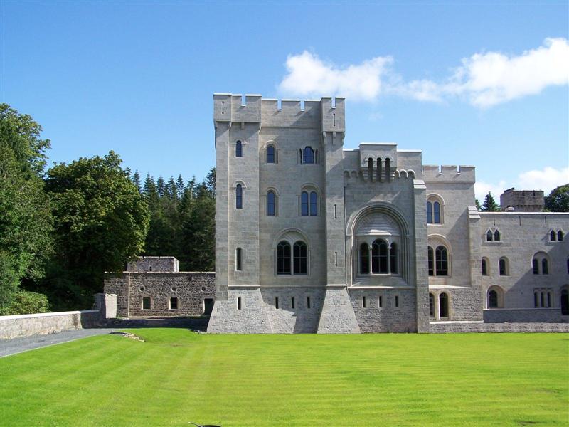
Gosford Castle is a 19th-century country house situated in Gosford, a townland of Markethill, County Armagh, Northern Ireland. It was built for Archibald Acheson, 2nd Earl of Gosford, and designed in the Norman revival style by London architect Thomas Hopper. It is a Grade A listed building, and is said to be Ulster's largest. The Earls of Gosford occupied the castle until 1921, and the estate was later purchased by the Ministry of Agriculture to form Gosford Forest Park. The building subsequently deteriorated and in 2006 was sold to a development company who converted the castle into private dwellings. History The Acheson family were granted land in County Armagh by King James VI & I in 1610, at the start of the Plantation of Ulster. They established the village of Markethill and built a castle, though this was destroyed during the Irish Rebellion of 1641. A manor house was built in its place, which the Achesons occupied until 1840. The writer Jonathan Swift (1667–1745) v ... [...More Info...] [...Related Items...] OR: [Wikipedia] [Google] [Baidu] |
Forest Service Northern Ireland
The Forest Service Northern Ireland is an executive agency of the Department of Agriculture and Rural Development entrusted with the development of forestry and the management of forests in Northern Ireland. It was created on 1 April 1998. The Forest Service holds headquarters at Inishkeen House in Enniskillen and forest offices in Castlewellan and Garvagh Garvagh ( or ''Garbhachadh'' meaning "rough field") is a village in County Londonderry, Northern Ireland. It is on the banks of the Agivey River, south of Coleraine on the A29 route. In the 2001 Census it had a population of 1,288. It is situ .... It manages 62,000 hectares of forest and employs 205 people. References ;Inline ;Other * Northern Ireland Executive Forestry agencies in the United Kingdom Organisations based in Belfast Rural society in the United Kingdom 1998 establishments in Northern Ireland Forests and woodlands of Northern Ireland Forestry in Ireland {{NorthernIreland-org-stub ... [...More Info...] [...Related Items...] OR: [Wikipedia] [Google] [Baidu] |
Irish Scout Jamborees
Scouting in Ireland has hosted many jamborees and jamborettes since Scouting started there in 1908. List Cancelled jamborees * 2001: ''Causeway 2001'' was planned by The Scout Association to be held in Co. Antrim. It was cancelled due to the 2001 outbreak of foot-and-mouth disease after extensive preparations took place. * 2013: Scouting Ireland's second jamboree was planned for 2013 in Stradbally Hall, home of the Electric Picnic music festival, in Stradbally Co. Laois. Deirdre Butler was the Camp Chief and in April 2013 ''Jamboree 2013'' was cancelled due to lack of bookings. Ballyfin '93 Ballyfin '93 took place in the grounds of Ballyfin College, Co. Laois, between 27 July and 5 August 1993. It was hosted by the Catholic Boy Scouts of Ireland, with the support and assistance of Scouting Ireland SAI and the Scout Association in Northern Ireland (a branch of the Scout Association in the UK). It was the third of four such jamborees rotated among the three Scout Associati ... [...More Info...] [...Related Items...] OR: [Wikipedia] [Google] [Baidu] |
Canada
Canada is a country in North America. Its ten provinces and three territories extend from the Atlantic Ocean to the Pacific Ocean and northward into the Arctic Ocean, covering over , making it the world's second-largest country by total area. Its southern and western border with the United States, stretching , is the world's longest binational land border. Canada's capital is Ottawa, and its three largest metropolitan areas are Toronto, Montreal, and Vancouver. Indigenous peoples have continuously inhabited what is now Canada for thousands of years. Beginning in the 16th century, British and French expeditions explored and later settled along the Atlantic coast. As a consequence of various armed conflicts, France ceded nearly all of its colonies in North America in 1763. In 1867, with the union of three British North American colonies through Confederation, Canada was formed as a federal dominion of four provinces. This began an accretion of provinces and ... [...More Info...] [...Related Items...] OR: [Wikipedia] [Google] [Baidu] |
Japan
Japan ( ja, 日本, or , and formally , ''Nihonkoku'') is an island country in East Asia. It is situated in the northwest Pacific Ocean, and is bordered on the west by the Sea of Japan, while extending from the Sea of Okhotsk in the north toward the East China Sea, Philippine Sea, and Taiwan in the south. Japan is a part of the Ring of Fire, and spans an archipelago of 6852 islands covering ; the five main islands are Hokkaido, Honshu (the "mainland"), Shikoku, Kyushu, and Okinawa. Tokyo is the nation's capital and largest city, followed by Yokohama, Osaka, Nagoya, Sapporo, Fukuoka, Kobe, and Kyoto. Japan is the eleventh most populous country in the world, as well as one of the most densely populated and urbanized. About three-fourths of the country's terrain is mountainous, concentrating its population of 123.2 million on narrow coastal plains. Japan is divided into 47 administrative prefectures and eight traditional regions. The Greater Tokyo Ar ... [...More Info...] [...Related Items...] OR: [Wikipedia] [Google] [Baidu] |
United States
The United States of America (U.S.A. or USA), commonly known as the United States (U.S. or US) or America, is a country primarily located in North America. It consists of 50 U.S. state, states, a Washington, D.C., federal district, five major unincorporated territories, nine United States Minor Outlying Islands, Minor Outlying Islands, and 326 Indian reservations. The United States is also in Compact of Free Association, free association with three Oceania, Pacific Island Sovereign state, sovereign states: the Federated States of Micronesia, the Marshall Islands, and the Palau, Republic of Palau. It is the world's List of countries and dependencies by area, third-largest country by both land and total area. It shares land borders Canada–United States border, with Canada to its north and Mexico–United States border, with Mexico to its south and has maritime borders with the Bahamas, Cuba, Russia, and other nations. With a population of over 333 million, it is the List of ... [...More Info...] [...Related Items...] OR: [Wikipedia] [Google] [Baidu] |


