|
Gmina Bukowsko
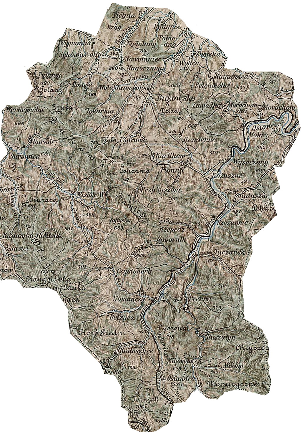
__NOTOC__ Gmina Bukowsko is a rural gmina (administrative district) in Sanok County, Subcarpathian Voivodeship, in south-eastern Poland. Its seat is the village of Bukowsko, which lies approximately south-west of Sanok and south of the regional capital Rzeszów. The gmina covers an area of , and as of 2006 its total population is 5,210. Sołectwos ;Ethnic Groups * Poles Hiking trails *European walking route E8 ** Iwonicz-Zdrój – Rymanów-Zdrój - Puławy – Tokarnia (778 m) – Przybyszów – Kamień (717 m) – Komańcza - Prełuki – Duszatyn – Jeziorka Duszatyńskie – (997 m) – Wołosań (1071 m) – Cisna - Połonina Caryńska – Szeroki Wierch – Rozsypaniec (1282 m)– Halicz – Przełęcz Bukowska - Tarnica – Ustrzyki Górne – Wołosate. Historical rural commune ''Gerichts-Bezirk'' of Austria-Hungary until 1918: Neighbouring gminas Gmina Bukowsko is bordered by the gminas of Komańcza, Rymanów, Sanok, Zagórz and Zarszyn ... [...More Info...] [...Related Items...] OR: [Wikipedia] [Google] [Baidu] |
Gmina
The gmina (Polish: , plural ''gminy'' , from German ''Gemeinde'' meaning ''commune'') is the principal unit of the administrative division of Poland, similar to a municipality. , there were 2,477 gminas throughout the country, encompassing over 43,000 villages. 940 gminas include cities and towns, with 302 among them constituting an independent urban gmina ( pl, gmina miejska) consisting solely of a standalone town or one of the 107 cities, the latter governed by a city mayor (''prezydent miasta''). The gmina has been the basic unit of territorial division in Poland since 1974, when it replaced the smaller gromada (cluster). Three or more gminas make up a higher level unit called powiat, except for those holding the status of a city with powiat rights. Each and every powiat has the seat in a city or town, in the latter case either an urban gmina or a part of an urban-rural one. Types There are three types of gmina: #302 urban gmina ( pl, gmina miejska) constituted either by ... [...More Info...] [...Related Items...] OR: [Wikipedia] [Google] [Baidu] |
Zboiska, Sanok County
Zboiska ( uk, Збоїська, ''Zboyis’ka'') – ''Boyscza'' 1361, ''Boyska'' 1398, ''Boyschcze'' 1402, ''Bogiska'' 1437, ''Szboyska'' 1539, Zboiska alias ''Uhrynowce'' 1676, is a village in East Małopolska in the Lesser Beskid mountains. It is in the Bukowsko rural commune and the parish of Bukowsko. Zboiska is about 10 miles from Sanok in south-west Poland. It is situated below the main watershed at the foot of the Słonne Mountain, and has an elevation of 340 metres. It is located in the Subcarpathian Voivodship (since 1999), but was previously in Krosno Voivodship (1975–1998) and Sanok district, (10 miles east of Sanok). Twin cities *Topoľovka *Maizières-lès-Metz, France Literature * Adam Fastnacht, Nagórzany n:Slownik Historyczno-Geograficzny Ziemi Sanockiej w Średniowieczu (Historic-Geographic Dictionary of the Sanok District in the Middle Ages), Kraków, (II edition 2002), . *Jerzy Zuba "W Gminie Bukowsko". Roksana, 2004, . Translated by Deborah Greenlee ... [...More Info...] [...Related Items...] OR: [Wikipedia] [Google] [Baidu] |
Puławy (województwo Podkarpackie)
Puławy (, also written Pulawy) is a city in eastern Poland, in Lesser Poland's Lublin Voivodeship, at the confluence of the Vistula and Kurówka Rivers. Puławy is the capital of Puławy County. The city's 2019 population was estimated at 47,417. Its coat of arms is based on Pogonia. Puławy was first mentioned in documents of the 15th century. At that time it was spelled ''Pollavy'', its name probably coming from a Vistula River ford located nearby. The town is a local center of science, industry and tourism, together with nearby Nałęczów and Kazimierz Dolny. Puławy is home to Poland's first permanent museum and is a Vistula River port. The town has two bridges and four rail stations, and serves as a road junction. Nearby Dęblin has a military airport. Location and transport Puławy lies in the western part of Lublin Voivodeship, at the edge of the picturesque Lesser Polish Gorge of the Vistula, and near the easternmost point of the Vistula river. Historically the to ... [...More Info...] [...Related Items...] OR: [Wikipedia] [Google] [Baidu] |
Rymanów-Zdrój
Rymanów-Zdrój (; uk, Риманів-Здрій) is a village and a spa in southern Poland, in Subcarpathian Voivodeship, in Krosno County. Location Rymanów-Zdrój lies south of the town of Rymanów, in the valley of the river Tabor surrounded by low mountains. It is located in the heartland of the Doły (Pits), and its average altitude is above sea level, although there are some hills located within the confines of the city. History The source of mineral water was discovered in 1876. The popularity of the nearby spa, Iwonicz Zdrój, caused the owners of the Rymanów estate, Anna and Stanisław Potocki, to look for similar springs in the river valley. A chemist, Tytus Sławik, who was staying with them, analyzed the water in a spring and found a high concentration of iodine and iron. In 1877, Prof. Dr Wesselshy, a Viennese chemist, confirmed the initial analysis. Shortly the first boarding, houses were built and pipes installed to bring the water from the spring to them. ... [...More Info...] [...Related Items...] OR: [Wikipedia] [Google] [Baidu] |
Iwonicz-Zdrój
Iwonicz-Zdrój (; uk, Іво́нич-Здруй), is a town in Poland, in Subcarpathian Voivodship, in Krosno County. It has 1,831 inhabitants (02.06.2009). It is located in the heartland of the Doły (Pits), and its average altitude is above sea level, although there are some hills located within the confines of the city. History Iwonicz-Zdroj is one of Poland's oldest health resorts and spas, dating back to 1578, which was famous outside Poland already in the 18th century. The town lies in the south-eastern part of Podkarpackie voivodship, Krosno province. The town is surrounded on all sides by high mixed forest. It lies at above sea level. This unusual location among hills of Beskid Niski, in the valley of Iwonicki Potok (Iwonicz Stream), undeniably rates Iwonicz highly among those places, which charm guests with their beauty and still immaculately clean air. The resort is at a distance of to the south from the voivodship capital – Rzeszów, and from Krosno. It i ... [...More Info...] [...Related Items...] OR: [Wikipedia] [Google] [Baidu] |
European Walking Route E8
The E8 European long distance path or E8 path is one of the European long-distance paths, leading 4,700 km (2,920 miles) across Europe, from Cork in Ireland to Bulgaria. Route After Ireland it crosses the Irish Sea into Wales and then into England, where it follows part of the Trans Pennine Trail. After crossing the North Sea, it passes through the Netherlands, Germany, Austria, Slovakia, Poland, Ukraine and Romania. It finally crosses Bulgaria before reaching the border to Turkey Turkey ( tr, Türkiye ), officially the Republic of Türkiye ( tr, Türkiye Cumhuriyeti, links=no ), is a list of transcontinental countries, transcontinental country located mainly on the Anatolia, Anatolian Peninsula in Western Asia, with .... History It was the first European long-distance path to be designated, and opened, in the UK. The section was opened in 1996. Some of the eastern sections of the route are yet to be finalised. External links E8 at the European Ramblers' Assoc ... [...More Info...] [...Related Items...] OR: [Wikipedia] [Google] [Baidu] |
Poles
Poles,, ; singular masculine: ''Polak'', singular feminine: ''Polka'' or Polish people, are a West Slavic nation and ethnic group, who share a common history, culture, the Polish language and are identified with the country of Poland in Central Europe. The preamble to the Constitution of the Republic of Poland defines the Polish nation as comprising all the citizens of Poland, regardless of heritage or ethnicity. The majority of Poles adhere to Roman Catholicism. The population of self-declared Poles in Poland is estimated at 37,394,000 out of an overall population of 38,512,000 (based on the 2011 census), of whom 36,522,000 declared Polish alone. A wide-ranging Polish diaspora (the '' Polonia'') exists throughout Europe, the Americas, and in Australasia. Today, the largest urban concentrations of Poles are within the Warsaw and Silesian metropolitan areas. Ethnic Poles are considered to be the descendants of the ancient West Slavic Lechites and other tribes that inhabit ... [...More Info...] [...Related Items...] OR: [Wikipedia] [Google] [Baidu] |
Pobiedno
Pobiedno is a village in Sanok County, which in turn is a part of Bukowsko rural commune in Nowotaniec parish. Geographically, the village is in the East Małopolska region of Poland and in the Lesser Beskid mountains. Nearby towns include Medzilaborce and Palota of northeastern Slovakia Slovakia (; sk, Slovensko ), officially the Slovak Republic ( sk, Slovenská republika, links=no ), is a landlocked country in Central Europe. It is bordered by Poland to the north, Ukraine to the east, Hungary to the south, Austria to the s .... References {{Gmina Bukowsko Pobiedno ... [...More Info...] [...Related Items...] OR: [Wikipedia] [Google] [Baidu] |
Wola Sękowa
Wola Sękowa ( uk, Воля Сенькова, ''Volia Sen’kova'') is a village in East Małopolska in the Bukowsko Upland mountains, Bukowsko rural commune, parish in Bukowsko. Wola Sękowa is about from Sanok in southeast Poland near the border with Slovakia and Ukraine. It is situated below the main watershed at the foot of the Słonne Mountain, and has an elevation of 340 metres. It is located in the Subcarpathian Voivodship (since 1999), previously in Krosno Voivodship (1975–1998) and Sanok district, ( east of Sanok). Nearby towns include Medzilaborce and Palota (in northeastern Slovakia). The village lies near the Pielnica River at the foot of the Bukowica mountains, which are the main trail in Pogórze Bukowskie. Hiking trails *European walking route E8 Literature * Prof. Adam Fastnacht Adam Fastnacht (27 July 1913, in Sanok – 16 February 1987, in Wrocław) doctor hab., historian, editor.Anna Fastnacht-Stupnicka. Obecność przeszłości (''O Adamie Fastnachc ... [...More Info...] [...Related Items...] OR: [Wikipedia] [Google] [Baidu] |
Tokarnia, Sanok County
Tokarnia ( uk, Токарня, ''Tokarnia''), village in East Małopolska in the Lesser Beskid mountains, Bukowsko rural commune. Tokarnia is about from Sanok in south-eastern Poland. It is situated below the main watershed at the foot of the Słonne Mountain, and has an elevation of . It is in the Subcarpathian Voivodship (since 1999), previously in Krosno Voivodship (1975–1998) and Sanok district. History Tokarnia was founded in 1526 by Herburt. From 1340-1772 (Ruthenian Voivodeship) and from 1918-1939 Tokarnia was part of Poland. While during 1772-1918 it belonged to Austrian empire, later Austrian-Hungarian empire when double monarchy was introduced in Austria. This part of Poland was controlled by Austria for almost 120 years. At that time the area (including west and east of Subcarpathian Voivodship) was known as Galicia. Religion In Tokarnia there used to be a Greek Catholic parish church, the church of St. Michael the Archangel (formerly called the church of Th ... [...More Info...] [...Related Items...] OR: [Wikipedia] [Google] [Baidu] |
Nowotaniec
Nowotaniec (german: Lobetanz, 1409; yi, ד בנוביטַניץ' Novitanitz; uk, Новотанець, ''Novotanets’'') is a village in south-eastern Poland, inhabited by about 430 (2002), in the Pogórze Bukowskie (Bukowsko Upland) mountains. Situated in the Subcarpathian Voivodeship (since 1999), previously in the Krosno Voivodeship (1975–1998) and the Sanok district, Bukowsko subdistrict, located near the towns of Medzilaborce and Palota (in northeastern Slovakia). Nowotaniec is bordered on the east by Bukowsko, on the north by Wola Sękowa, on the west by Nadolany, on the right bank of the Pielnica river (a tributary of the Wisłok), on the left side of the highway nr 889 from the railroad running from Sanok to Krosno, and on the west by forests covering the slopes of the Bukowica Range. This village consists of one street which runs north to south displaying Latin church stone and several houses. The parish belongs to the Diocese of Przemyśl, deanery of Sanok. It ... [...More Info...] [...Related Items...] OR: [Wikipedia] [Google] [Baidu] |


.jpg)