|
George Bligh Bank
George Bligh Bank is a seamount that lies in the Rockall Trough. It is a roughly circular feature in the northeast Atlantic, west of Scotland, centred at approximately 59°N, 14°W at the northern end of both the Hatton and Rockall Banks. The bank is approximately 75 km in diameter with a summit at approximately 450 m rising from a depth of over 1000 m. The ‘moat’ around the base of George Bligh Bank deepens from north to south and is deeper than 1650 m in the south.Narayanaswamy, B.E., Hughes, D.J., Howell, K.L., Davies, J., Jacobs, C. (2013) First observations of megafaunal communities inhabiting George Bligh Bank, Northeast Atlantic. Deep Sea Research Part II: Topical Studies in Oceanography, 92: 79-86. George Bligh Bank is part of the Rockall-Hatton Plateau, a large piece of continental crust that separated from the northwest European continental margin around 100 million years ago. It is not of volcanic origin and thus is not recognized as a seamount under the OSPAR ... [...More Info...] [...Related Items...] OR: [Wikipedia] [Google] [Baidu] |
Seamount
A seamount is a large geologic landform that rises from the ocean floor that does not reach to the water's surface (sea level), and thus is not an island, islet or cliff-rock. Seamounts are typically formed from extinct volcanoes that rise abruptly and are usually found rising from the seafloor to in height. They are defined by oceanographers as independent features that rise to at least above the seafloor, characteristically of conical form.IHO, 2008. Standardization of Undersea Feature Names: Guidelines Proposal form Terminology, 4th ed. International Hydrographic Organization and Intergovernmental Oceanographic Commission, Monaco. The peaks are often found hundreds to thousands of meters below the surface, and are therefore considered to be within the deep sea. During their evolution over geologic time, the largest seamounts may reach the sea surface where wave action erodes the summit to form a flat surface. After they have subsided and sunk below the sea surface such ... [...More Info...] [...Related Items...] OR: [Wikipedia] [Google] [Baidu] |
Rockall Trough
The Rockall Trough ( gd, Clais Sgeir Rocail) is a deep-water bathymetric feature to the northwest of Scotland and Ireland, running roughly from southwest to northeast, flanked on the north by the Rockall Plateau and to the south by the Porcupine Seabight. At the northern end, the channel is bounded by the Wyville-Thomson Ridge, named after Charles Wyville Thomson, professor of zoology at the University of Edinburgh and driving force behind the Challenger Expedition. At the southern end, the trough opens into the Porcupine abyssal plain. The Rockall Basin (also known as the Hatton Rockall Basin) is a large (c. 800 km by 150 km) sedimentary basin that lies beneath the trough. Both are named after Rockall, a rocky islet lying 301.4 km west of St Kilda. Features of the Rockall Plateau have been officially named after features of Middle-earth in the fiction of J. R. R. Tolkien, e.g. Eriador Seamount, Rohan Seamount, Gondor Seamount, Fangorn Bank, Edoras Bank ... [...More Info...] [...Related Items...] OR: [Wikipedia] [Google] [Baidu] |
Atlantic
The Atlantic Ocean is the second-largest of the world's five oceans, with an area of about . It covers approximately 20% of Earth's surface and about 29% of its water surface area. It is known to separate the "Old World" of Africa, Europe and Asia from the "New World" of the Americas in the European perception of the World. The Atlantic Ocean occupies an elongated, S-shaped basin extending longitudinally between Europe and Africa to the east, and North and South America to the west. As one component of the interconnected World Ocean, it is connected in the north to the Arctic Ocean, to the Pacific Ocean in the southwest, the Indian Ocean in the southeast, and the Southern Ocean in the south (other definitions describe the Atlantic as extending southward to Antarctica). The Atlantic Ocean is divided in two parts, by the Equatorial Counter Current, with the North(ern) Atlantic Ocean and the South(ern) Atlantic Ocean split at about 8°N. Scientific explorations of the Atl ... [...More Info...] [...Related Items...] OR: [Wikipedia] [Google] [Baidu] |
Scotland
Scotland (, ) is a country that is part of the United Kingdom. Covering the northern third of the island of Great Britain, mainland Scotland has a border with England to the southeast and is otherwise surrounded by the Atlantic Ocean to the north and west, the North Sea to the northeast and east, and the Irish Sea to the south. It also contains more than 790 islands, principally in the archipelagos of the Hebrides and the Northern Isles. Most of the population, including the capital Edinburgh, is concentrated in the Central Belt—the plain between the Scottish Highlands and the Southern Uplands—in the Scottish Lowlands. Scotland is divided into 32 administrative subdivisions or local authorities, known as council areas. Glasgow City is the largest council area in terms of population, with Highland being the largest in terms of area. Limited self-governing power, covering matters such as education, social services and roads and transportation, is devolved from the ... [...More Info...] [...Related Items...] OR: [Wikipedia] [Google] [Baidu] |
OSPAR Convention
The Convention for the Protection of the Marine Environment of the North-East Atlantic or OSPAR Convention is the current legislative instrument regulating international cooperation on environmental protection in the North-East Atlantic. Work carried out under the convention is managed by the OSPAR Commission, which is made up of representatives of the Governments of the 15 signatory nations, and representatives of the European Commission, representing the European Union. The OSPAR Convention was concluded at Paris on 22 September 1992. It combines and up-dates the 1972 Oslo Convention on dumping waste at sea and the 1974 Paris Convention on land-based sources of marine pollution. The name is likewise a combination of "Oslo" and "Paris". History The Convention for the Protection of the Marine Environment of the North-East Atlantic was opened for signature at the Ministerial Meeting of the Oslo and Paris Commissions in Paris on 22 September 1992. The Convention has been s ... [...More Info...] [...Related Items...] OR: [Wikipedia] [Google] [Baidu] |
Lophelia Pertusa
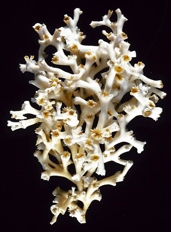
''Lophelia pertusa'', the only species in the genus ''Lophelia'', is a cold-water coral that grows in the deep waters throughout the North Atlantic ocean, as well as parts of the Caribbean Sea and Alboran Sea. Although ''L. pertusa'' reefs are home to a diverse community, the species is extremely slow growing and may be harmed by destructive fishing practices, or oil exploration and extraction. Biology ''Lophelia pertusa'' is a reef building, deep water coral, but it does not contain zooxanthellae, the symbiotic algae which lives inside most tropical reef building corals. ''Lophelia'' lives at a temperature range from about and at depths between and over , but most commonly at depths of , where there is no sunlight. As a coral, it represents a colonial organism, which consists of many individuals. New polyps live and build upon the calcium carbonate skeletal remains of previous generations. Living coral ranges in colour from white to orange-red; each polyp has up to 1 ... [...More Info...] [...Related Items...] OR: [Wikipedia] [Google] [Baidu] |
Research Vessel
A research vessel (RV or R/V) is a ship or boat designed, modified, or equipped to carry out research at sea. Research vessels carry out a number of roles. Some of these roles can be combined into a single vessel but others require a dedicated vessel. Due to the demanding nature of the work, research vessels may be constructed around an icebreaker hull, allowing them to operate in polar waters. History The research ship had origins in the early voyages of exploration. By the time of James Cook's ''Endeavour'', the essentials of what today we would call a research ship are clearly apparent. In 1766, the Royal Society hired Cook to travel to the Pacific Ocean to observe and record the transit of Venus across the Sun. The ''Endeavour'' was a sturdy vessel, well designed and equipped for the ordeals she would face, and fitted out with facilities for her "research personnel", Joseph Banks. As is common with contemporary research vessels, ''Endeavour'' also carried out more ... [...More Info...] [...Related Items...] OR: [Wikipedia] [Google] [Baidu] |
RV George Bligh
RV ''George Bligh'' (LO309) was a fisheries research vessel that was operated by the Directorate of Fisheries, now known as the Centre for Environment, Fisheries and Aquaculture Science (Cefas). Originally built as an Admiralty for use in the First World war ''George Bligh'' was registered in London but based at the port of Lowestoft, on the East Anglian coast. Like some other the Mersey-class naval trawlers were given names taken from the roll-call of Nelson's ship . ''George Bligh'' was named after Captain George Miller Bligh (1780–1834), an officer of the Royal Navy, who saw service during the French Revolutionary and Napoleonic Wars, eventually rising to the rank of captain. He was present aboard HMS ''Victory'' at the Battle of Trafalgar, and was badly wounded during the action.Russell, E.S (1929) The work of the fisheries laboratory, Lowestoft. Science Progress in the Twentieth Century (1919-1933), 23 (91): 457-467. Construction and World War I The Admiralty tr ... [...More Info...] [...Related Items...] OR: [Wikipedia] [Google] [Baidu] |
Ministry Of Agriculture, Fisheries And Food (United Kingdom)
The Ministry of Agriculture, Fisheries and Food (MAFF) was a Departments of the United Kingdom Government, United Kingdom government department created by the Board of Agriculture Act 1889 (52 & 53 Vict. c.30) and at that time called the Board of Agriculture, and then from 1903 the Board of Agriculture and Fisheries, and from 1919 the Ministry of Agriculture and Fisheries. It attained its final name in 1955 with the addition of responsibilities for the British food industry to the existing responsibilities for agriculture and the fishing industry, a name that lasted until the Ministry was dissolved in 2002, at which point its responsibilities had been merged into the Department for Environment, Food and Rural Affairs (Defra). On its renaming as the Ministry of Agriculture, Fisheries and Food in 1955, it was responsible for agriculture, fisheries and food. Until the Food Standards Agency was created, it was responsible for both food production and food safety, which was seen by s ... [...More Info...] [...Related Items...] OR: [Wikipedia] [Google] [Baidu] |
West Of Scotland Marine Protected Area
The West of Scotland Marine Protected Area covers a large area of the North Atlantic to the west of the Outer Hebrides. The Marine Protected Area (MPA) was designated by the Scottish Government in 2020, replacing the Rosemary Bank MPA, which covered a much smaller area. Covering a sea area of over , it is the largest marine protected area in Europe. The MPA covers a diverse range of marine landscapes. Moving west, these include: the steep gradient of the continental slope; the sediment plains of the Rockall Trough; and the rising slopes of George Bligh Bank and the Rockall Bank. The area also includes two isolated seamounts: Anton Dohrn and Rosemary Bank. It protects several important habitats including deep-sea sponge aggregations and cold water coral reefs and gardens. Six species of deep-sea fish are specifically protected within the MPA: blue ling, orange roughy, leafscale gulper shark, gulper shark, Portuguese dogfish The Portuguese dogfish (''Centroscymnus coel ... [...More Info...] [...Related Items...] OR: [Wikipedia] [Google] [Baidu] |


