|
Geology Of Barbados
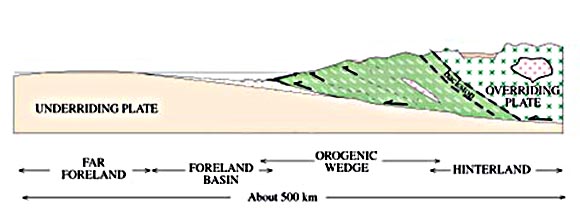
The geology of the island Barbados includes exposures of reef-related carbonate rocks spanning 85 percent of the island's surface. This coral rock formation is 70 meters thick and dates to the Pleistocene. Unlike neighboring islands in the Lesser Antilles volcanic arc, Barbados is unusual because it is not a volcanic island (the only volcanic rocks are some ash beds from eruptions on neighboring islands). Instead, the island of Barbados is the exposed part of the Barbados Ridge Accretionary Prism, left as deep ocean sediments "scraped" to the surface as the Atlantic oceanic crust subducted beneath the Caribbean Plate. The oldest rocks are in the Scotland Formation and include Eocene age turbidite and radiolarites. This unit is 4.5 kilometers thick from the sea floor to the surface. It is overlain by a syncline basin called the Woodbourne Trough, which includes pelagic sediments. Nappe formations of the Oceanic Formation, from a Miocene The Miocene ( ) is the first epoch (geology ... [...More Info...] [...Related Items...] OR: [Wikipedia] [Google] [Baidu] |
Barbados
Barbados, officially the Republic of Barbados, is an island country in the Atlantic Ocean. It is part of the Lesser Antilles of the West Indies and the easternmost island of the Caribbean region. It lies on the boundary of the South American Plate, South American and Caribbean Plate, Caribbean plates. Its capital and largest city is Bridgetown. Inhabited by Island Caribs, Kalinago people since the 13th century, and prior to that by other Indigenous peoples of the Americas, Indigenous peoples, Barbados was claimed for the Crown of Castile by Spanish navigators in the late 15th century. It first appeared on a Spanish map in 1511. The Portuguese Empire claimed the island between 1532 and 1536, but abandoned it in 1620 with their only remnants being the introduction of wild boars intended as a supply of meat whenever the island was visited. An Kingdom of England, English ship, the ''Olive Blossom'', arrived in Barbados on 14 May 1625; its men took possession of the island in the n ... [...More Info...] [...Related Items...] OR: [Wikipedia] [Google] [Baidu] |
Pleistocene
The Pleistocene ( ; referred to colloquially as the ''ice age, Ice Age'') is the geological epoch (geology), epoch that lasted from to 11,700 years ago, spanning the Earth's most recent period of repeated glaciations. Before a change was finally confirmed in 2009 by the International Union of Geological Sciences, the cutoff of the Pleistocene and the preceding Pliocene was regarded as being 1.806 million years Before Present (BP). Publications from earlier years may use either definition of the period. The end of the Pleistocene corresponds with the end of the last glacial period and also with the end of the Paleolithic age used in archaeology. The name is a combination of Ancient Greek () 'most' and (; Latinized as ) 'new'. The aridification and cooling trends of the preceding Neogene were continued in the Pleistocene. The climate was strongly variable depending on the glacial cycle, oscillating between cold Glacial period, glacial periods and warmer Interglacial, int ... [...More Info...] [...Related Items...] OR: [Wikipedia] [Google] [Baidu] |
Eocene
The Eocene ( ) is a geological epoch (geology), epoch that lasted from about 56 to 33.9 million years ago (Ma). It is the second epoch of the Paleogene Period (geology), Period in the modern Cenozoic Era (geology), Era. The name ''Eocene'' comes from the Ancient Greek (''Ēṓs'', 'Eos, Dawn') and (''kainós'', "new") and refers to the "dawn" of modern ('new') fauna that appeared during the epoch.See: *Letter from William Whewell to Charles Lyell dated 31 January 1831 in: * From p. 55: "The period next antecedent we shall call Eocene, from ήως, aurora, and χαινος, recens, because the extremely small proportion of living species contained in these strata, indicates what may be considered the first commencement, or ''dawn'', of the existing state of the animate creation." The Eocene spans the time from the end of the Paleocene Epoch to the beginning of the Oligocene Epoch. The start of the Eocene is marked by a brief period in which the concentration of the carbon isoto ... [...More Info...] [...Related Items...] OR: [Wikipedia] [Google] [Baidu] |
Turbidite
A turbidite is the geologic Deposition (geology), deposit of a turbidity current, which is a type of amalgamation of fluidal and sediment gravity flow responsible for distributing vast amounts of clastic sediment into the deep ocean. Sequencing Turbidites were first properly described by Arnold H. Bouma (1962), who studied deepwater sediments and recognized particular "fining-up intervals" within deep water, fine-grained shales, which were anomalous because they started at pebble Conglomerate (geology), conglomerates and terminated in shales. This was anomalous because within the deep ocean it had historically been assumed that there was no mechanism by which tractional flow could carry and deposit coarse-grained sediments into the abyssal depths. Bouma sequence, Bouma cycles begin with an erosional contact of a coarse lower bed of pebble to granule conglomerate in a sandy matrix, and grade up through coarse then medium plane parallel sandstone; through cross-bedded sandstone; ... [...More Info...] [...Related Items...] OR: [Wikipedia] [Google] [Baidu] |
Syncline
In structural geology, a syncline is a fold with younger layers closer to the center of the structure, whereas an anticline is the inverse of a syncline. A synclinorium (plural synclinoriums or synclinoria) is a large syncline with superimposed smaller folds. Synclines are typically a downward fold (synform), termed a synformal syncline (i.e. a trough), but synclines that point upwards can be found when strata have been overturned and folded (an antiformal syncline). Characteristics On a geologic map, synclines are recognized as a sequence of rock layers, with the youngest at the fold's center or ''hinge'' and with a reverse sequence of the same rock layers on the opposite side of the hinge. If the fold pattern is circular or elongate, the structure is a basin. Folds typically form during crustal deformation as the result of compression that accompanies orogenic mountain building. Notable examples * Powder River Basin, Wyoming, US * Sideling Hill roadcut along Inters ... [...More Info...] [...Related Items...] OR: [Wikipedia] [Google] [Baidu] |
Nappe
In geology, a nappe or thrust sheet is a large sheetlike body of rock that has been moved more than or above a thrust fault from its original position. Nappes form in compressional tectonic settings like continental collision zones or on the overriding plate in active subduction zones. Nappes form when a mass of rock is forced (or "thrust") over another rock mass, typically on a low angle fault plane. The resulting structure may include large-scale recumbent folds, shearing along the fault plane,Twiss, Robert J. and Eldridge M. Moores, ''Structural Geology,'' W. H. Freeman, 1992, p. 236 imbricate thrust stacks, fensters and klippes. The term stems from the French word for ''tablecloth'' in allusion to a rumpled tablecloth being pushed across a table. History Nappes or nappe belts are a major feature of the European Alps, Dinarides, Carpathians and Balkans. Since the 19th century many geologists have uncovered areas with large-scale overthrusts. Some of these were su ... [...More Info...] [...Related Items...] OR: [Wikipedia] [Google] [Baidu] |
Miocene
The Miocene ( ) is the first epoch (geology), geological epoch of the Neogene Period and extends from about (Ma). The Miocene was named by Scottish geologist Charles Lyell; the name comes from the Greek words (', "less") and (', "new") and means "less recent" because it has 18% fewer modern marine invertebrates than the Pliocene has. The Miocene followed the Oligocene and preceded the Pliocene. As Earth went from the Oligocene through the Miocene and into the Pliocene, the climate slowly cooled towards a series of ice ages. The Miocene boundaries are not marked by distinct global events but by regionally defined transitions from the warmer Oligocene to the cooler Pliocene Epoch. During the Early Miocene, Afro-Arabia collided with Eurasia, severing the connection between the Mediterranean and Indian Oceans, and allowing the interchange of fauna between Eurasia and Africa, including the dispersal of proboscideans and Ape, hominoids into Eurasia. During the late Miocene, the conn ... [...More Info...] [...Related Items...] OR: [Wikipedia] [Google] [Baidu] |
Diapir
A diapir (; , ) is a type of intrusion in which a more mobile and ductilely deformable material is forced into brittle overlying rocks. Depending on the tectonic environment, diapirs can range from idealized mushroom-shaped Rayleigh–Taylor instability structures in regions with low tectonic stress such as in the Gulf of Mexico to narrow dikes of material that move along tectonically induced fractures in surrounding rock. The term was introduced by Romanian geologist Ludovic Mrazek, who was the first to understand the principle of salt tectonics and plasticity. The term ''diapir'' may be applied to '' igneous intrusions'', but it is more commonly applied to non-igneous, relatively cold materials, such as salt domes and mud diapirs. If a salt diapir reaches the surface, it can flow because salt becomes ductile with a small amount of moisture, forming a salt glacier. Occurrence Differential loading causes salt deposits covered by overburden (sediment) to rise upward tow ... [...More Info...] [...Related Items...] OR: [Wikipedia] [Google] [Baidu] |


