|
Fortescue Bay
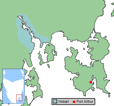
Fortescue Bay or Baje Dolomien is a bay in southeast Tasmania, Australia. It is located east of Port Arthur, Tasmania, and makes up part of Tasman National Park. Within the bay are two smaller nested bays, Canoe Bay and Bivouac Bay. History Timber mill During the early 1900s, a timber mill was started at Fortescue Bay by G. Albury and Turner Brothers. At the beginning of the 1920s, the Gathercole Brothers company began advertising for men to work at their mill. It is possible that the Gathercole Brothers carried on operation of the mill owned by G. Albury and Turner Brothers, as they owned several mills around Port Arthur. Fish works Until the early 1970s, Canoe Bay played host to a fish works. Shipwreck On 1 July 1953, a dredge named for William Pitt was towed from Hobart to Fortescue Bay and scuttled in the mouth of Canoe Bay at the request of the Minister for Agricultural and Sea Fisheries. The dredge was scuttled to act as a breakwater for the many fishing vessels usin ... [...More Info...] [...Related Items...] OR: [Wikipedia] [Google] [Baidu] |
Tasmania
) , nickname = , image_map = Tasmania in Australia.svg , map_caption = Location of Tasmania in AustraliaCoordinates: , subdivision_type = Country , subdivision_name = Australia , established_title = Before federation , established_date = Colony of Tasmania , established_title2 = Federation , established_date2 = 1 January 1901 , named_for = Abel Tasman , demonym = , capital = Hobart , largest_city = capital , coordinates = , admin_center = 29 local government areas , admin_center_type = Administration , leader_title1 = Monarch , leader_name1 = Charles III , leader_title2 = Governor , leader_n ... [...More Info...] [...Related Items...] OR: [Wikipedia] [Google] [Baidu] |
Port Arthur, Tasmania
Port Arthur is a town and former convict settlement on the Tasman Peninsula, in Tasmania, Australia. It is located approximately southeast of the state capital, Hobart. The site forms part of the Australian Convict Sites, a World Heritage property consisting of 11 remnant penal sites originally built within the British Empire during the 18th and 19th centuries on fertile Australian coastal strips. Collectively, these sites, including Port Arthur, are described by UNESCO as "... the best surviving examples of large-scale convict transportation and the colonial expansion of European powers through the presence and labour of convicts." In 1996, the town was the scene of the Port Arthur Massacre, the worst instance of mass murder in post-colonial Australian history. Location Port Arthur is located about southeast of the state capital, Hobart, on the Tasman Peninsula. The scenic drive from Hobart, via the Tasman Highway to Sorell and the Arthur Highway to Port Arthur, tak ... [...More Info...] [...Related Items...] OR: [Wikipedia] [Google] [Baidu] |
Tasman National Park
The Tasman National Park is a national park in eastern Tasmania, Australia, approximately east of Hobart. The park is situated on part of both the Forestier and Tasman peninsulas and encompasses all of Tasman Island. History Whaling activity took place in the 1830s and 1840s. The park was proclaimed under the Regional Forest Agreement on 30 April 1999. The Tasman Island Lighthouse (constructed in 1906) is located on Tasman Island, which is part of the park. This lighthouse and weather station has been unmanned since 1977.Brothers, Nigel; Pemberton, David; Pryor, Helen; & Halley, Vanessa. (2001). ''Tasmania’s Offshore Islands: seabirds and other natural features''. Tasmanian Museum and Art Gallery: Hobart. Geography At above sea level, the columnar dolerite cliffs at Cape Pillar and Tasman Island are among the highest in the world. Dolerite is a rare rock type on mainland Australia. Land formations accessible by road include the Blowhole (a hole at the inland end o ... [...More Info...] [...Related Items...] OR: [Wikipedia] [Google] [Baidu] |
Canoe Bay
A canoe is a lightweight narrow water vessel, typically pointed at both ends and open on top, propelled by one or more seated or kneeling paddlers facing the direction of travel and using a single-bladed paddle. In British English, the term ''canoe'' can also refer to a kayak, while canoes are called Canadian or open canoes to distinguish them from kayaks. Canoes were developed by cultures all over the world, including some designed for use with sails or outriggers. Until the mid-19th century, the canoe was an important means of transport for exploration and trade, and in some places is still used as such, sometimes with the addition of an outboard motor. Where the canoe played a key role in history, such as the Northern United States, Canada, and New Zealand, it remains an important theme in popular culture. Canoes are now widely used for competition and pleasure, such as racing, whitewater, touring and camping, freestyle and general recreation. Canoeing has been part o ... [...More Info...] [...Related Items...] OR: [Wikipedia] [Google] [Baidu] |
William Pitt (architect)
William Pitt (4 June 1855 – 25 May 1918) was an Australian architect and politician. Pitt is best known as one of the outstanding architects of the "boom" era of the 1880s in Melbourne, designing some of the city's most elaborate High Victorian commercial buildings. He worked in a range of styles including Gothic Revival, Italianate, French Second Empire, and his own inventive eclectic compositions. He had a notable second career after the crash of the 1890s, becoming a specialist in theatres and industrial buildings. Early life William Pitt was born in 1855 in MelbourneAustralian Dictionary of Biography Online Edition two years after his parents emigrated to Australia from |
Hobart
Hobart ( ; Nuennonne/ Palawa kani: ''nipaluna'') is the capital and most populous city of the Australian island state of Tasmania. Home to almost half of all Tasmanians, it is the least-populated Australian state capital city, and second-smallest if territories are taken into account, before Darwin, Northern Territory. Hobart is located in Tasmania's south-east on the estuary of the River Derwent, making it the most southern of Australia's capital cities. Its skyline is dominated by the kunanyi/Mount Wellington, and its harbour forms the second-deepest natural port in the world, with much of the city's waterfront consisting of reclaimed land. The metropolitan area is often referred to as Greater Hobart, to differentiate it from the City of Hobart, one of the five local government areas that cover the city. It has a mild maritime climate. The city lies on country which was known by the local Mouheneener people as nipaluna, a name which includes surrounding features such a ... [...More Info...] [...Related Items...] OR: [Wikipedia] [Google] [Baidu] |
Hobart Bridge
The Hobart Bridge was a floating arch bridge that crossed the River Derwent, connecting the eastern and western shores of the city of Hobart, Tasmania, Australia. History Plans for a bridge to link the Derwent River’s two shores near Hobart date back to 1832. It was not until 1943 that the first bridge was completed, the Hobart floating bridge and lift span. The bridge was opened to toll traffic on 22 December 1943 and the collection of tolls continued until midnight on 31 December 1948. Soon after its opening a violent storm blew in and damaged a section of the bridge, and to prevent the same happening again, the bridge was anchored to the riverbed in the middle and strengthening cables were added to stiffen the structure. After these modifications were completed the lifespan of the bridge was estimated as 21 years. It was closed on the 17 August 1964. The bridge provided much better connection between the eastern and western shores, and consequently development on the ... [...More Info...] [...Related Items...] OR: [Wikipedia] [Google] [Baidu] |
Devonport, Tasmania
Devonport ( ; Palawa Kani: ''Tiagarra'') is a city in northern Tasmania, Australia, located on the lands of the Pannilerpanner clan of the Palawa nation. It is situated at the mouth of the Mersey River. Devonport had an urban population of 26,150 at the 2021 Australian census. History The first European settlement before 1850 was on a block of land at Frogmore, near present-day Latrobe. In 1850, a settler named Oldaker occupied land at present-day Devonport. Saw milling and coal mining developed with settlers arriving from England in 1854 on board the sailing ship 'Balmoral'. During the 1850s the twin settlements of Formby and Torquay were established on opposite banks at the mouth of the Mersey River. Torquay on the eastern shore was the larger community with police, post, magistrate, at least three hotels, shipyards and stores. A river ferry service connected the two communities. Between 1870 and 1880 the shipping industry grew and work was undertaken to deepen the mouth of ... [...More Info...] [...Related Items...] OR: [Wikipedia] [Google] [Baidu] |
Melbourne Harbor Trust
The Melbourne Harbor Trust was established in 1877 to improve and operate port facilities for the growing city of Melbourne. It was superseded by the Port of Melbourne Authority in 1978 and later by the Port of Melbourne Corporation. Creation In the 1860s and 1870s, agitation for the establishment of a trust on the lines of those on the Mersey at Liverpool, and especially the Clyde Navigation Trust (which was run by Glasgow's leading merchants), came predominantly from the Melbourne Chamber of Commerce. However, Williamstown and Geelong interests opposed the measure, while Alfred Clark (the member of parliament for Williamstown) warned "''...if ships were to be taken up the river then grass will grow on the piers and streets of Williamstown''." The trust reflected Melbourne mercantile interests but the government was hostile towards it. At the time there was little coordinated management or development of Melbourne ports facilities, with a variety of privately built wharves ... [...More Info...] [...Related Items...] OR: [Wikipedia] [Google] [Baidu] |
Bush Walking
Hiking is a long, vigorous walk, usually on trails or footpaths in the countryside. Walking for pleasure developed in Europe during the eighteenth century.AMATO, JOSEPH A. "Mind over Foot: Romantic Walking and Rambling." In ''On Foot: A History of Walking'', 101-24. NYU Press, 2004. Accessed March 1, 2021. http://www.jstor.org/stable/j.ctt9qg056.7. Religious pilgrimages have existed much longer but they involve walking long distances for a spiritual purpose associated with specific religions. "Hiking" is the preferred term in Canada and the United States; the term "walking" is used in these regions for shorter, particularly urban walks. In the United Kingdom and the Republic of Ireland, the word "walking" describes all forms of walking, whether it is a walk in the park or backpacking in the Alps. The word hiking is also often used in the UK, along with rambling , hillwalking, and fell walking (a term mostly used for hillwalking in northern England). The term bushwalking is e ... [...More Info...] [...Related Items...] OR: [Wikipedia] [Google] [Baidu] |


