|
Fordbridge
Fordbridge is a civil parish in England between Kingshurst and Chelmsley Wood in the Metropolitan Borough of Solihull, which is in the West Midlands and also part of the West Midlands conurbation. It is east of Birmingham city centre. It has a town council. According to the 2001 census, the parish had a population of 8,749. Fordbridge lies within the historic county of Warwickshire. The area falls within the borders of North Solihull, parts of which are currently undergoing a £1.8 billion regeneration project. Many inhabitants of Fordbridge do not recognise it as a distinct area, instead classing it as part of the larger Chelmsley Wood Estate. The area around the eastern end of Cooks Lane is also often referred to as "Bacon's End". Etymology Fordbridge gets its name from the crossing over the River Cole on Cooks Lane, which was referred to as "Ford Bridge" on 19th century OS maps. This name suggests this site was previously a ford, but eventually a bridge was bui ... [...More Info...] [...Related Items...] OR: [Wikipedia] [Google] [Baidu] |
Metropolitan Borough Of Solihull
The Metropolitan Borough of Solihull is a metropolitan borough in West Midlands county, England. It is named after its largest town, Solihull, from which Solihull Metropolitan Borough Council is based. For Eurostat purposes it is a NUTS 3 region (code UKG32) and is one of seven boroughs or unitary districts that comprise the "West Midlands" NUTS 2 region. Much of the large residential population in the north of the borough centres on the communities of Castle Bromwich, Fordbridge, Kingshurst, Marston Green and Smith's Wood as well as the town of Chelmsley Wood. In the south are the towns of Solihull and Shirley, and the large villages of Knowle, Dorridge, Meriden and Balsall Common. Since 2011, Solihull has formed part of the Greater Birmingham & Solihull Local Enterprise Partnership along with neighbouring authorities Birmingham, Bromsgrove, Cannock Chase, East Staffordshire, Lichfield, Redditch, Tamworth and Wyre Forest. History Solihull probably derived its ... [...More Info...] [...Related Items...] OR: [Wikipedia] [Google] [Baidu] |
John Henry Newman Catholic College
John Henry Newman Catholic College (JHNCC), formerly ''Archbishop Grimshaw School'', is an English secondary school in the Fordbridge area of Solihull, although it lies in the Metropolitan Borough of Solihull The Metropolitan Borough of Solihull is a metropolitan borough in West Midlands county, England. It is named after its largest town, Solihull, from which Solihull Metropolitan Borough Council is based. For Eurostat purposes it is a NUTS 3 reg .... History It was formerly called Archbishop Grimshaw before 2011, when the school converted to academy status and the name of the school was changed to the John Henry Newman Catholic College. With an Ofsted report of outstanding in 2012/2013. References Secondary schools in Solihull Catholic secondary schools in the Archdiocese of Birmingham Academies in Solihull {{England-org-stub ... [...More Info...] [...Related Items...] OR: [Wikipedia] [Google] [Baidu] |
Meriden (UK Parliament Constituency)
Meriden is a constituency represented in the House of Commons of the UK Parliament since 2019 by Saqib Bhatti, a Conservative. It is named after the village of Meriden, halfway between Solihull and Coventry. Members of Parliament The MP from 1997 to 2019 was the Conservative Caroline Spelman. Conservative Saqib Bhatti took over the position after the 2019 General Election. Constituency profile The constituency is one of two covering the Metropolitan Borough of Solihull. It covers the rural area known as the Meriden Gap located between the West Midlands conurbation and Coventry, which contains villages such as Balsall Common, Hampton-in-Arden, and Meriden itself, with some suburban towns, particularly Castle Bromwich and Chelmsley Wood (a large area of 1960s council housing on the eastern edge of Birmingham, some of which since acquired privately under the right to buy others of which being remaining social housing), higher than average national income and ... [...More Info...] [...Related Items...] OR: [Wikipedia] [Google] [Baidu] |
Kingshurst
Kingshurst is a post-war housing estate and civil parish in the Metropolitan Borough of Solihull, in the West Midlands. It lies about east of Birmingham city centre. Smith's Wood borders it to the north and east, Fordbridge to the south and the Shard End area of Birmingham to the west. History The name Kingshurst comes from having previously been a Royal Manor, and "hurst" meaning wood. The earliest record of Kingshurst is in documents from the late 13th and early 14th centuries, when it is referred to as part of the Manor of Coleshill. Tenant farming was administered from here and Simon de Montford of Coleshill was an English nobleman who built a moated manor house near Kingshurst. The Hall had its own park and farmlands. The Mountfords 1332-1618 Kingshurst took on an independent existence from Coleshill with the arrival of the Mountfords. It is unclear how Kingshurst came into their possession although it is probable that they bought the area around 1332 from the Clint ... [...More Info...] [...Related Items...] OR: [Wikipedia] [Google] [Baidu] |
Chelmsley Wood
Chelmsley Wood is a town and civil parish in the Metropolitan Borough of Solihull, West Midlands, England, with a population of 12,453. It is located near Birmingham Airport and the National Exhibition Centre. It lies about eight miles east of Birmingham City Centre and 5 miles to the north of Solihull. The town is also close to both Coleshill and Water Orton in Warwickshire. In 1966 Birmingham City Council compulsorily purchased the ancient woodland and built the 15,590 dwelling council estate to rehouse families on its council house waiting list. With the rise in unemployment in the 1970s parts of the estate suffered from deprivation and anti-social behaviour. The area established a town council. Local government re-organisation in 1974 transferred the town to Solihull Metropolitan Borough, though responsibility for the housing remained with Birmingham until September 1980. History Chelmsley Wood was built by Birmingham City Council in the late 1960s and early 70s on ... [...More Info...] [...Related Items...] OR: [Wikipedia] [Google] [Baidu] |
Smith's Wood
Smith's Wood is a residential area in the north of the Metropolitan Borough of Solihull in the West Midlands (county), West Midlands of England. It is a civil parish with a population of 10,476, according to the 2011 census. The A452 road, A452 and M6 motorway, M6 form its north and east boundary, Kingshurst and Fordbridge its south, and Castle Bromwich its west. Smith's Wood also has several parks that are being redeveloped. The Smith's Wood estate is the site of the ancient 'Smith's Wood' – a historical woodland which was once part of the Arden, Warwickshire, forest of Arden. It was officially designated a Local Nature Reserve in 2004 and is going to be enhanced as part of the regeneration project along with other green spaces. Smith's Wood is home tSmith's Wood Boys Football Club a large boys' football club established in 1970. Nottingham Forest F.C., Nottingham Forest forward Jamie Ward is from Smith's Wood and attended Smith's Wood Sports College. Many flats and hous ... [...More Info...] [...Related Items...] OR: [Wikipedia] [Google] [Baidu] |
Birmingham New Street Railway Station
Birmingham New Street is the largest and busiest of the three main railway stations in Birmingham city centre, England, and a central hub of the British railway system. It is a major destination for Avanti West Coast services from , and via the West Coast Main Line, the CrossCountry network, and for local and suburban services within the West Midlands; this includes those on the Cross-City Line between , and , and the Chase Line to and . The three-letter station code is BHM. The station is named after New Street, which runs parallel to the station, although the station has never had a direct entrance except via the Grand Central shopping centre. Historically, the main entrance to the station was on Stephenson Street, just off New Street. As of 2022, the station has entrances on Stephenson Street, Smallbrook Queensway, Hill Street and Navigation Street. New Street is the fifth busiest railway station in the UK and the busiest outside London, with 46.5 million passen ... [...More Info...] [...Related Items...] OR: [Wikipedia] [Google] [Baidu] |
Birmingham International Railway Station
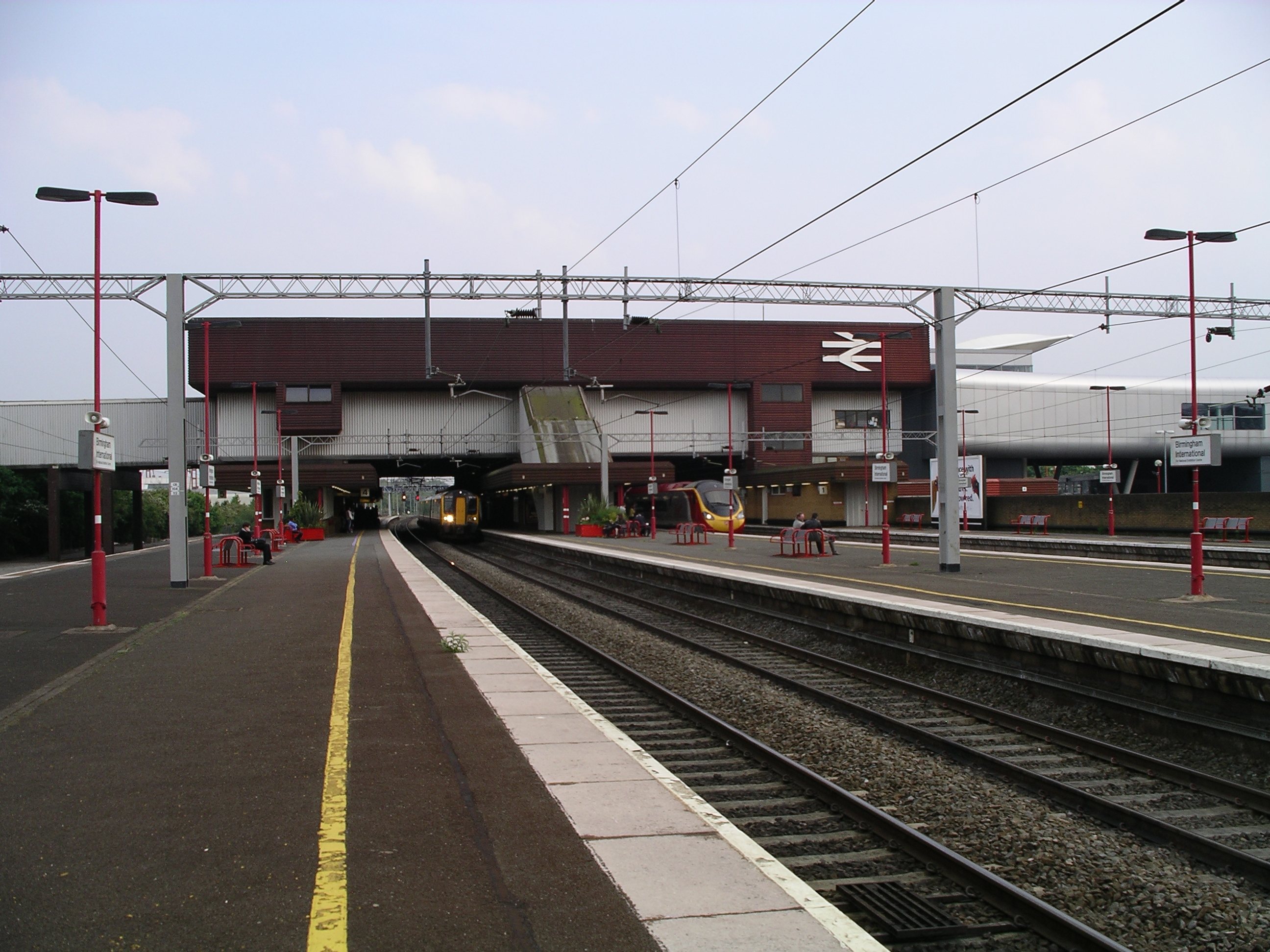
Birmingham International is a railway station located in Solihull in the West Midlands, to the east of the city of Birmingham, England. The station is on the Rugby–Birmingham–Stafford Line 14 km (8½ miles) east of Birmingham New Street and serves Birmingham Airport, National Exhibition Centre (incorporating the Resorts World Arena) and Resorts World Birmingham. History The station was designed by the architect Ray Moorcroft and opened on 26 January 1976; it has regular train services to many parts of the country. It was named Birmingham International after the adjacent airport which was, at the time, named Birmingham International Airport, but has since been rebranded as Birmingham Airport. The large space under the overbridge to the left of the southbound platforms suggests space was allowed for future expansion of the station. In 2016, it was proposed to rename it to ''Birmingham Airport & NEC'', due to the airport's name change and the near presence of the N ... [...More Info...] [...Related Items...] OR: [Wikipedia] [Google] [Baidu] |
Marston Green Railway Station
Marston Green railway station is located in the suburb of Marston Green, in the borough of Solihull, West Midlands, England. It is the nearest station to Chelmsley Wood. The station, and all trains serving it, are operated by West Midlands Trains. History The station opened on 9 April 1838 as part of the LNWR's line between and . Unlike many of the other small rail stations constructed in the mid 19th century around Birmingham, Marston Green station has remained open to passengers since it was opened. However, none of the railway station's original features remain, having been replaced during the 1970s. Facilities The station has a ticket office located on platform 1 which is open Monday-Thursday 06:15-19:00, Friday 06:15-20:00, Saturday 08:00-20:00 and Sunday 09:00-14:00. When the ticket office is open tickets must be purchased before boarding the train. Outside of these times there is a ticket machine on platform 2 which accepts card payments only - cash and voucher payment ... [...More Info...] [...Related Items...] OR: [Wikipedia] [Google] [Baidu] |
The International School And Community College
Tile Cross Academy is a coeducational secondary school located in the Tile Cross area of Birmingham, West Midlands, England. Admissions The school is ethnically diverse and contains around 700 pupils spread over three major buildings. The school is situated on ''Gressel Lane'' and is roughly one mile from Lea Hall railway station, operated by London Midland. It is close to the eastern boundary of Birmingham, close to the Solihull boundary. History Former schools The genesis of the school was three schools being built next to each other in Tile Cross, East Birmingham in the late 1950s. The famous Central Grammar School for Boys was founded in 1897 on Suffolk Street and relocated to ''Gressel Lane'' in September 1957. It was a three-form entry school with around 550 boys. During the second World War half of the school was evacuated and shared with The West Monmouth High School for Boys at Pontypool under the Headship of Leslie Bradley, who had been appointed Headmaster in 1934 ... [...More Info...] [...Related Items...] OR: [Wikipedia] [Google] [Baidu] |
Sutton Coldfield
Sutton Coldfield or the Royal Town of Sutton Coldfield, known locally as Sutton ( ), is a town and civil parish in the City of Birmingham, West Midlands, England. The town lies around 8 miles northeast of Birmingham city centre, 9 miles south of Lichfield, 7 miles southwest of Tamworth and 7 miles east of Walsall. Sutton Coldfield and its surrounding suburbs are governed under Birmingham City Council for local government purposes but the town has its own town council which governs the town and its surrounding areas by running local services and electing a mayor to the council. It is in the Historic county of Warwickshire, and in 1974 it became part of Birmingham and the West Midlands metropolitan county under the Local Government Act 1972. History Etymology The etymology of the name Sutton appears to be from "South Town". The name "Sutton Coldfield" appears to come from this time, being the "south town" (i.e. south of Tamworth and/or Lichfield) on the edge of ... [...More Info...] [...Related Items...] OR: [Wikipedia] [Google] [Baidu] |
Castle Bromwich
Castle Bromwich () is a large suburban village situated within the Metropolitan Borough of Solihull in the English county of the West Midlands. It is bordered by the rest of the borough to the south east; also Sutton Coldfield to the east and north east, Shard End to the south west, Castle Vale, Erdington and Minworth to the north and Hodge Hill to the west – all areas of the City of Birmingham. It constitutes a civil parish, which had a population of 11,857 according to the 2001 census, falling to 11,217 at the 2011 census. The population has remained quite stable since then; the 2017 population estimate was 12,309. It was a civil parish within the Meriden Rural District of Warwickshire until the Local Government Act 1972 came into force in 1974, when it became part of the Metropolitan Borough of Solihull. In 1861, the population was 613. This rose to just over 1,000 in the 1920s, when half of the original parish was ceded to the City of Birmingham for the construct ... [...More Info...] [...Related Items...] OR: [Wikipedia] [Google] [Baidu] |

.jpg)


