|
Flood History In Chehalis, Washington
The city of Chehalis is located in Washington state and rests upon the Chehalis River. Due to the city's location in the Chehalis Valley along with the nearby confluences of the Newaukum River south of Chehalis and the Skookumchuck River in neighboring Centralia, the community has suffered from numerous floods. Some floods have occurred resulting from overflows of creeks and minor tributaries in the Chehalis river basin, and severe cresting of the Cowlitz River has occasionally led to flooding in the Chehalis area. The flood stage levels of the Chehalis, Newaukum, and Skookumchuck have fluctuated upwards historically, based on the height of dikes, levees, and floodplain surveys. Water inundation from heavy rains and excessive snowmelt has led to a considerable number of historic flooding events in the twin cities of Centralia and Chehalis. Accounts of floods are traced as far back as early Native American settlement and since the beginnings of the city of Chehalis. Most floods ... [...More Info...] [...Related Items...] OR: [Wikipedia] [Google] [Baidu] |
100-year Flood
A 100-year flood is a flood event that has a 1 in 100 chance (1% probability) of being equaled or exceeded in any given year. The 100-year flood is also referred to as the 1% flood, since its annual exceedance probability is 1%.Holmes, R.R., Jr., and Dinicola, K. (2010) ''100-Year flood–it's all about chance 'U.S. Geological Survey General Information Product 106/ref> For coastal or lake flooding, the 100-year flood is generally expressed as a flood elevation or depth, and may include wave effects. For river systems, the 100-year flood is generally expressed as a flowrate. Based on the expected 100-year flood flow rate, the flood water level can be mapped as an area of inundation. The resulting floodplain map is referred to as the 100-year floodplain. Estimates of the 100-year flood flowrate and other streamflow statistics for any stream in the United States are available.Ries, K.G., and others (2008) ''StreamStats: A water resources web application 'U.S. Geological Survey, Fac ... [...More Info...] [...Related Items...] OR: [Wikipedia] [Google] [Baidu] |
Lintott-Alexander Park
Lintott-Alexander Park is a park in Chehalis, Washington, located west of Interstate 5, I-5 and south of Washington State Route 6. Due to its location in a bend of the Chehalis River (Washington), Chehalis River and at the confluence of the Newaukum River, the park can flood in most years. History Locally referred to as Alexander Park after the family who owned the grounds, the land was used as a park by the regional population before it was donated to the city of Chehalis. The park, situated in a curve of the Chehalis River, was known at the time for its deep swimming hole, also known locally as the Ol' Swimmin' Hole, and its sandy beach. Initial offers by the Alexander family to donate the land for a park began in 1919 and in April 1920, the parcel was deeded to the city. Plans such as the building of bath houses, water and sewer systems, and more accommodating access from Ocean Beach Highway, were undertaken before it was to be officially transferred. The Alexander family f ... [...More Info...] [...Related Items...] OR: [Wikipedia] [Google] [Baidu] |
Portland, Oregon
Portland (, ) is a port city in the Pacific Northwest and the largest city in the U.S. state of Oregon. Situated at the confluence of the Willamette and Columbia rivers, Portland is the county seat of Multnomah County, the most populous county in Oregon. Portland had a population of 652,503, making it the 26th-most populated city in the United States, the sixth-most populous on the West Coast, and the second-most populous in the Pacific Northwest, after Seattle. Approximately 2.5 million people live in the Portland metropolitan statistical area (MSA), making it the 25th most populous in the United States. About half of Oregon's population resides within the Portland metropolitan area. Named after Portland, Maine, the Oregon settlement began to be populated in the 1840s, near the end of the Oregon Trail. Its water access provided convenient transportation of goods, and the timber industry was a major force in the city's early economy. At the turn of the 20th centu ... [...More Info...] [...Related Items...] OR: [Wikipedia] [Google] [Baidu] |
Twin City Railroad
The Twin City Railroad Company was organized in 1912 as successor to the Twin City Light and Traction Company and acquired its subsidiaries, the Chehalis Electric and Traction Company and the Centralia Electric and Traction Company. Until 1936, when the line was abandoned, the company operated the electric line that connected the Twin Cities of Chehalis, Washington (the “Rose City”) and Centralia (the “Hub City”). History Early reporting mentions that a steam-powered streetcar existed in Centralia during the 1890s but ended due to the loss of the locomotive in a fire. Work to begin an electric streetcar line to connect the Twin Cities began in 1905 under the direction of the Centralia-Chehalis Electric Railway & Power Company. The clearance of the right-of-way was started in 1909. The line was reported as built under the Twin City Traction Company name and the rail lines were laid from the middle of stretch, working first towards Chehalis as the final route into Centra ... [...More Info...] [...Related Items...] OR: [Wikipedia] [Google] [Baidu] |
Southwest Washington Fairgrounds
The points of the compass are a set of horizontal, radially arrayed compass directions (or azimuths) used in navigation and cartography. A compass rose is primarily composed of four cardinal directions—north, east, south, and west—each separated by 90 degrees, and secondarily divided by four ordinal (intercardinal) directions—northeast, southeast, southwest, and northwest—each located halfway between two cardinal directions. Some disciplines such as meteorology and navigation further divide the compass with additional azimuths. Within European tradition, a fully defined compass has 32 'points' (and any finer subdivisions are described in fractions of points). Compass points are valuable in that they allow a user to refer to a specific azimuth in a colloquial fashion, without having to compute or remember degrees. Designations The names of the compass point directions follow these rules: 8-wind compass rose * The four cardinal directions are north (N), east (E), so ... [...More Info...] [...Related Items...] OR: [Wikipedia] [Google] [Baidu] |
Plank Road
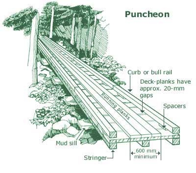
A plank road is a road composed of wooden planks or puncheon logs. Plank roads were commonly found in the Canadian province of Ontario Ontario ( ; ) is one of the thirteen provinces and territories of Canada.Ontario is located in the geographic eastern half of Canada, but it has historically and politically been considered to be part of Central Canada. Located in Central C ... as well as the Northeastern United States, Northeast and Midwestern United States, Midwest of the United States in the first half of the 19th century. They were often built by toll road, turnpike companies. Origins The Wittmoor bog trackway is the name given to each of two historic plank roads or boardwalks, trackway No. I being discovered in 1898 and trackway No. II in 1904 in the ''Wittmoor'' bog in northern Hamburg, Germany. The trackways date to the 4th and 7th century AD, both linked the eastern and western shores of the formerly inaccessible, swampy bog. A part of the older trackway No. II ... [...More Info...] [...Related Items...] OR: [Wikipedia] [Google] [Baidu] |
David Douglas (botanist)
David Douglas (25 June 1799 – 12 July 1834) was a Scottish botanist, best known as the namesake of the Douglas fir. He worked as a gardener, and explored the Scottish Highlands, North America, and Hawaii, where he died. Early life Douglas was born in Scone, Perthshire, the second son of John Douglas, a stonemason, and Jean Drummond. He attended Kinnoull School and upon leaving found work as an apprentice to William Beattie, head gardener at Scone Palace, the seat of the Earl of Mansfield. He spent seven years in this position, completing his apprenticeship, and then spent a winter at a college in Perth to learn more of the scientific and mathematical aspects of plant culture. After a further spell of working at Valleyfield House in Fife (during which time he had access to a library of botanical and zoological books) he moved to the Botanical Gardens of Glasgow University and attended botany lectures. William Jackson Hooker, who was Garden Director and Professor of ... [...More Info...] [...Related Items...] OR: [Wikipedia] [Google] [Baidu] |
Confederated Tribes Of The Chehalis Reservation
The Confederated Tribes of the Chehalis Reservation is a federally recognized tribe of Upper and Lower Chehalis, Klallam, Muckleshoot, Nisqually, and Quinault peoples. They are one of the Northern Straits branch Central Coast Salish peoples of indigenous peoples of the Northwest Coast. Their tribe is located in southwest Washington. The Confederated Tribes' traditional territories were along the Black, Chehalis, Cowlitz, Elk, Johns, Newaukum, Satsop, Shookumchuck, and Wynoochee Rivers, and near Grays Harbor and on the lower Puget Sound of Washington."Our Story." ''The Chehalis Tribes.'' Retrieved 19 Sept 2013. Reservation [...More Info...] [...Related Items...] OR: [Wikipedia] [Google] [Baidu] |
Mount St
Mount is often used as part of the name of specific mountains, e.g. Mount Everest. Mount or Mounts may also refer to: Places * Mount, Cornwall, a village in Warleggan parish, England * Mount, Perranzabuloe, a hamlet in Perranzabuloe parish, Cornwall, England * Mounts, Indiana, a community in Gibson County, Indiana, United States People * Mount (surname) * William L. Mounts (1862–1929), American lawyer and politician Computing and software * Mount (computing), the process of making a file system accessible * Mount (Unix), the utility in Unix-like operating systems which mounts file systems Displays and equipment * Mount, a fixed point for attaching equipment, such as a hardpoint on an airframe * Mounting board, in picture framing * Mount, a hanging scroll for mounting paintings * Mount, to display an item on a heavy backing such as foamcore, e.g.: ** To pin a biological specimen, on a heavy backing in a stretched stable position for ease of dissection or display ... [...More Info...] [...Related Items...] OR: [Wikipedia] [Google] [Baidu] |
Cowlitz Indian Tribe
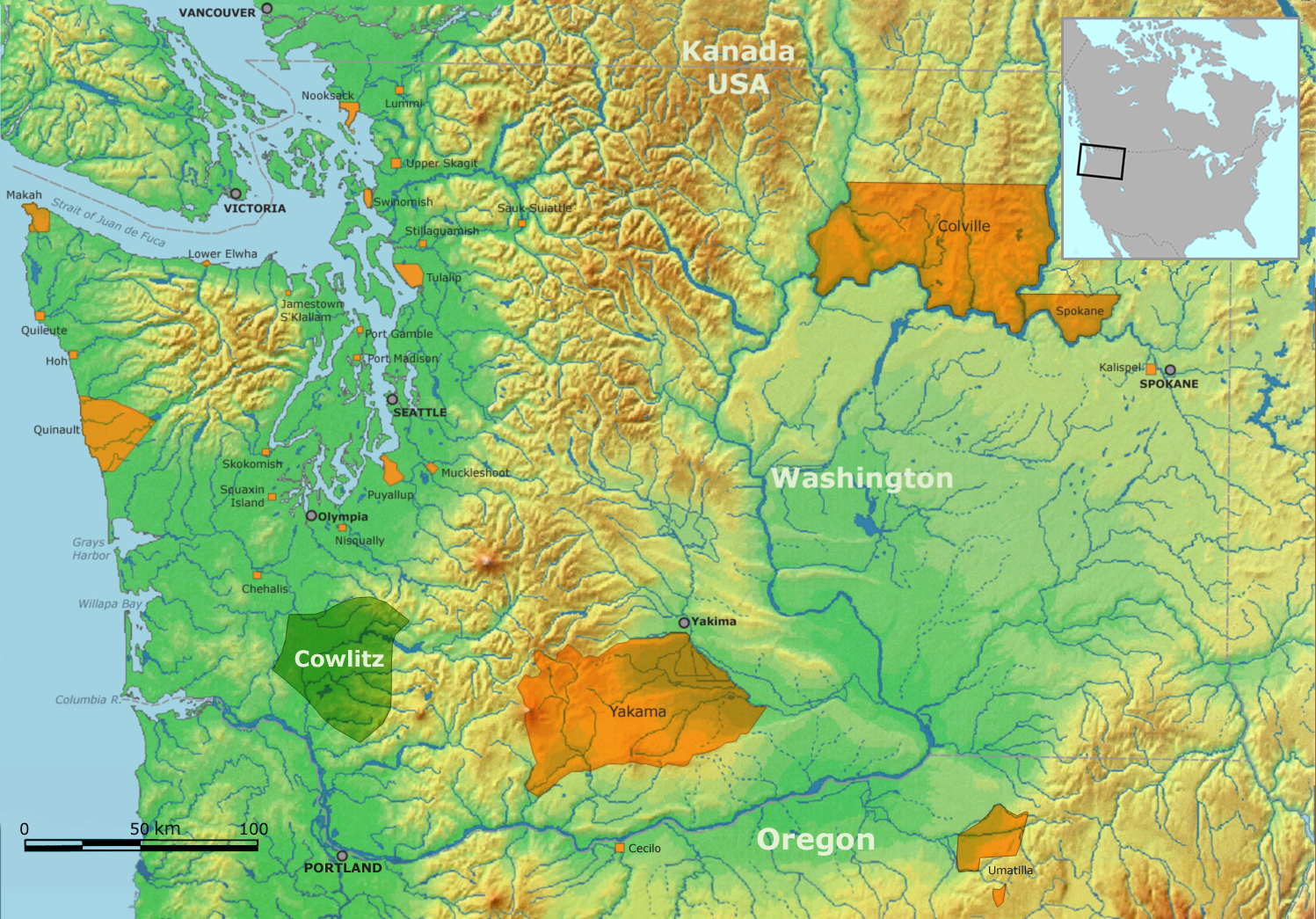
The Cowlitz Indian Tribe is a federally recognized tribe of Cowlitz people. They are a tribe of Southwestern Coast Salish and Sahaptan indigenous people of the Pacific Northwest located in Washington. Other Cowlitz people are enrolled in the Confederated Tribes of the Chehalis Reservation, Confederated Tribes and Bands of the Yakima Nation, and Quinault Indian Nation. Reservation The Cowlitz Reservation was established in 2010. The reservation is located near Ridgefield, in Clark County, Washington. Government The Cowlitz Indian Tribe is headquartered in Longview, Washington. The tribe is governed by a democratically elected board of tribal council members. Salish is commonly spoken by the tribe. The Cowlitz language The Cowlitz language is a member of the Tsamosan branch of the Coast Salish family of Salishan languages. Cowlitz people The Cowlitz people were originally two distinct tribes: the Lower Cowlitz and the Upper Cowlitz. Only the Lower Cowlitz spok ... b ... [...More Info...] [...Related Items...] OR: [Wikipedia] [Google] [Baidu] |


