|
Flagstaff Hill, Tasmania
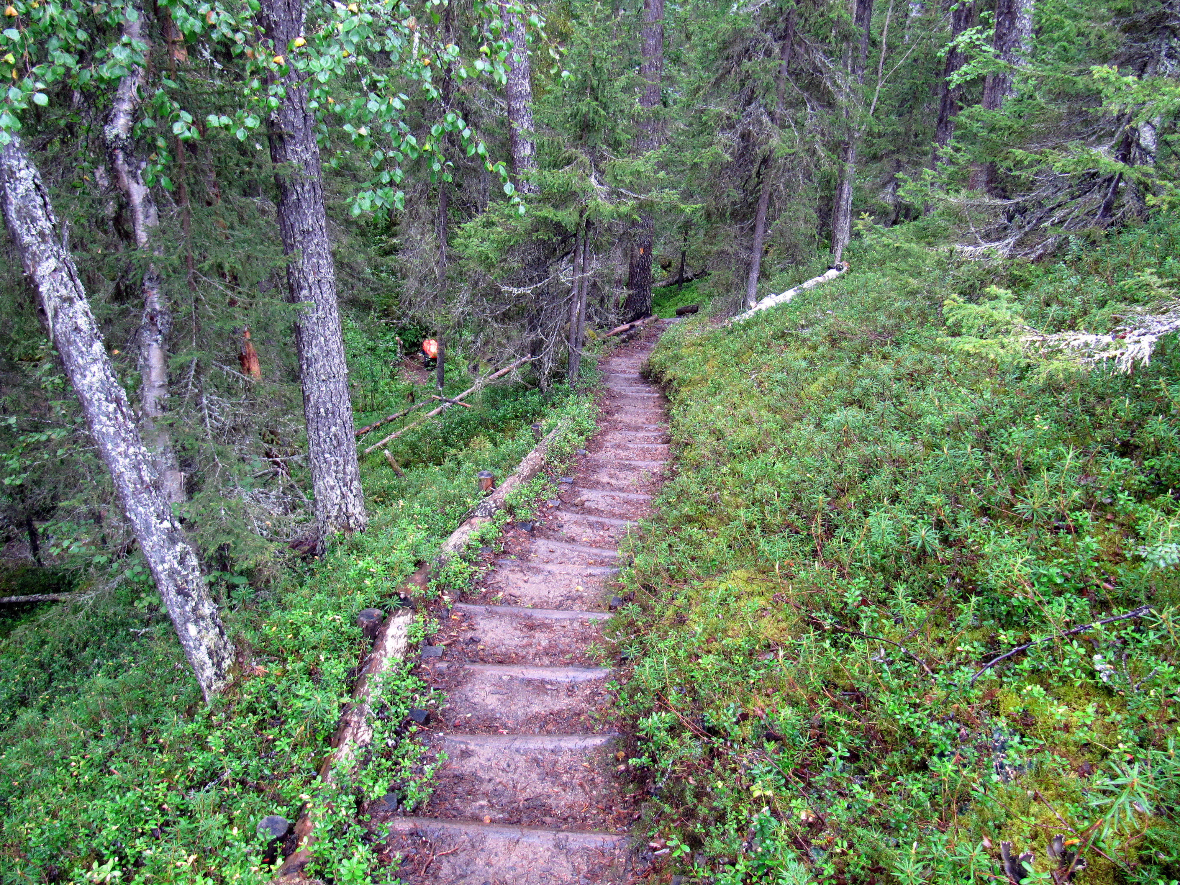
Flagstaff Hill is the highest peak within the Meehan Range in southeastern Tasmania, Australia, situated on the eastern shore of the island's capital, Hobart. It rises to an elevation of above sea level. Despite its name, "Flagstaff Hill" is a misnomer, as a mountain is typically defined as a landform that rises at least above the surrounding terrain. With a prominence of and a central location within the Meehan Range Nature Recreation Area, Flagstaff Hill serves as a prominent landmark on Hobart's eastern shore. History The name "Flagstaff Hill" is thought to derive from its historical use as a signalling or lookout point, leveraging its elevated position overlooking the River Derwent. During the mid-20th century, areas surrounding the hill were used for military training and operations. Flagstaff Hill and the Meehan Range were heavily affected by bushfire in 2006. The fire, driven by strong winds and dry conditions, threatened nearby suburbs, including Flags ... [...More Info...] [...Related Items...] OR: [Wikipedia] [Google] [Baidu] |
Meehan Range
The Meehan Range ( ) is a prominent geographic feature in southeastern Tasmania, consisting of steep hills and ridges running parallel to the River Derwent (Tasmania), River Derwent on the eastern shore of Hobart. Situated primarily in the City of Clarence, the range is protected as a natural area and offers a mix of conservation and recreational opportunities. The range includes bushwalking tracks and a growing network of mountain bike trails. The range is named after James Meehan (surveyor), James Meehan, an early surveyor of colonial Van Diemen's Land. It features two distinct orientations: the western slopes face the River Derwent and are heavily urbanised, while the eastern slopes overlook Pitt Water (Tasmania), Pitt Water and remain largely rural, although increasingly subdivided into commuter properties. Environment The Meehan Range is largely covered in native bushland and serves as critical habitat for a variety of flora and fauna. The range forms part of the Sout ... [...More Info...] [...Related Items...] OR: [Wikipedia] [Google] [Baidu] |
Gunners Quoin
Gunners Quoin ( ) is a distinctive mountain located in Tasmania, Australia. The formation is part of the Meehan Range. It is situated between the City of Clarence and Brighton Council local government areas on Hobart’s eastern shore. Known for its unique jagged shape and prominence in the surrounding landscape, the Quoin is a popular site for bushwalking, photography, and ecological studies due to its rich biodiversity and striking geological features. Geography Gunners Quoin is situated northeast of Hobart, Tasmania's capital city, in a region characterised by rugged terrain and dense forests. Sources vary on the mountain’s exact elevation, with listings citing either , or . The mountain offers panoramic views of the River Derwent and surrounding valleys. It is accessible via the East Derwent Highway. Geology The geology of Gunners Quoin is significant for its composition of dolerite, a type of igneous rock that forms much of Tasmania’s mountainous terrain. The ... [...More Info...] [...Related Items...] OR: [Wikipedia] [Google] [Baidu] |
Landmarks In Tasmania
A landmark is a recognizable natural or artificial feature used for navigation, a feature that stands out from its near environment and is often visible from long distances. In modern-day use, the term can also be applied to smaller structures or features that have become local or national symbols. Etymology In Old English, the word ''landmearc'' (from ''land'' + ''mearc'' (mark)) was used to describe a boundary marker, an "object set up to mark the boundaries of a kingdom, estate, etc." Starting around 1560, this interpretation of "landmark" was replaced by a more general one. A landmark became a "conspicuous object in a landscape". A ''landmark'' literally meant a geographic feature used by explorers and others to find their way back to their departure point, or through an area. For example, Table Mountain near Cape Town, South Africa, was used as a landmark to help sailors navigate around the southern tip of Africa during the Age of Exploration. Artificial structures are ... [...More Info...] [...Related Items...] OR: [Wikipedia] [Google] [Baidu] |
Geography Of Hobart
Geography (from Ancient Greek ; combining 'Earth' and 'write', literally 'Earth writing') is the study of the lands, features, inhabitants, and phenomena of Earth. Geography is an all-encompassing discipline that seeks an understanding of Earth and its human and natural complexities—not merely where objects are, but also how they have changed and come to be. While geography is specific to Earth, many concepts can be applied more broadly to other celestial bodies in the field of planetary science. Geography has been called "a bridge between natural science and social science disciplines." Origins of many of the concepts in geography can be traced to Greek Eratosthenes of Cyrene, who may have coined the term "geographia" (). The first recorded use of the word γεωγραφία was as the title of a book by Greek scholar Claudius Ptolemy (100 – 170 AD). This work created the so-called "Ptolemaic tradition" of geography, which included "Ptolemaic cartographic theory." ... [...More Info...] [...Related Items...] OR: [Wikipedia] [Google] [Baidu] |
East Derwent Highway
The East Derwent Highway (route number B32) is a highway in Hobart, Tasmania, Australia. The highway is a trunk road that carries heavy commuter traffic, much like the Brooker Highway, on the eastern side of the River Derwent. Route The highway starts at the roundabout with Midland Highway at Bridgewater and heads south as a dual-lane, single carriageway road, connecting with the Bowen Bridge over the River Derwent, widening to a four-lane, dual-carriageway road through Risdon, narrowing again to a dual-lane, single-carriageway road through Geilston Bay, and then widening to a four-lane, single-carriageway road to eventually terminate at the Lindisfarne Interchange at Rose Bay, near the eastern side of the Tasman Bridge leading into central Hobart. Exits and intersections See also * Highways in Australia * List of highways in Tasmania The Highways in Tasmania generally expand from Hobart and other major cities with secondary roads interconnecting the ... [...More Info...] [...Related Items...] OR: [Wikipedia] [Google] [Baidu] |
Tasman Highway
The Tasman Highway (or A3) is a highway in Tasmania, Australia. Like the Midland Highway (Tasmania), Midland Highway, it connects the major cities of Hobart and Launceston, Tasmania, Launceston – however it takes a different route, via the north-eastern and eastern coasts of the state. The Highway also acts as a major commuter road to Hobart residents living on the eastern side of the Derwent River (Tasmania), Derwent River. The designation "Tasman Highway" arises from its location facing the Tasman Sea – named, like the state itself, after Abel Tasman. The highway is one of the longest in Tasmania – , with an average travelling time of 4 hours. Eastern Outlet The Eastern Outlet is a section of the Tasman Highway between Hobart city centre, Hobart and Sorell, Tasmania, Sorell. As one of the city's 3 major radial highways, the outlet connects traffic from the Hobart city centre with Hobart Airport and commuters on the eastern shore of the River Derwent (Tasmania), River ... [...More Info...] [...Related Items...] OR: [Wikipedia] [Google] [Baidu] |
Birdwatching
Birdwatching, or birding, is the observing of birds, either as a recreational activity or as a form of citizen science. A birdwatcher may observe by using their naked eye, by using a visual enhancement device such as binoculars or a telescope, by listening for bird sounds, watching public webcams, or by viewing smart bird feeder cameras. Most birdwatchers pursue this activity for recreational or social reasons, unlike ornithologists, who engage in the study of birds using formal scientific methods. Birding, birdwatching, and twitching The first recorded use of the term ''birdwatcher'' was in 1712 by William Oldsworth. The term ''birding'' was also used for the practice of ''fowling'' or hunting with firearms as in Shakespeare's '' The Merry Wives of Windsor'' (1602): "She laments sir... her husband goes this morning a-birding." The terms ''birding'' and ''birdwatching'' are today used by some interchangeably, although some participants prefer ''birding'', partly because ... [...More Info...] [...Related Items...] OR: [Wikipedia] [Google] [Baidu] |
Bushwalking
A hike is a long, vigorous walking, walk, usually on trails or footpaths in the countryside. Walking for pleasure developed in Europe during the eighteenth century. Long hikes as part of a religious pilgrimage have existed for a much longer time. "Hiking" is the preferred term in Canada and the United States; the term "walking" is used in these regions for shorter, particularly urban walks. In the United Kingdom and Ireland, the word "walking" describes all forms of walking, whether it is a walk in the park or backpacking (wilderness), backpacking in the Alps. The word hiking is also often used in the UK, along with rambling, hillwalking, and fell walking (a term mostly used for hillwalking in northern England). The term bushwalking is endemic to Australia, having been adopted by the Sydney Bush Walkers Club in 1927. In New Zealand a long, vigorous walk or hike is called Tramping in New Zealand, tramping. It is a popular activity with numerous :Hiking organizations, hiking organ ... [...More Info...] [...Related Items...] OR: [Wikipedia] [Google] [Baidu] |
Forty-spotted Pardalote
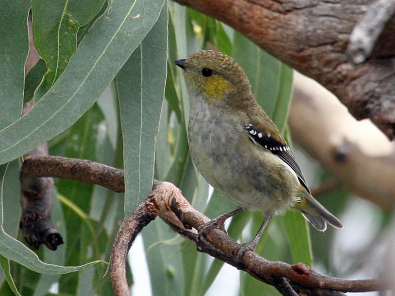
The forty-spotted pardalote (''Pardalotus quadragintus'') is one of Australia's rarest birds and by far the rarest pardalote, being confined to a few colonies in the south-east corner of Tasmania, mainly on Maria Island and Bruny Island. Description A small, energetic passerine about long, the forty-spot is similar to the much commoner spotted pardalote (''Pardalotus punctatus''), but has a dull greenish-brown back and head, compared to the more colourful plumage of the latter, with which it shares its range, and there is no brow line. The rump is olive, the under-tail dull yellow. The chest is white with light yellow tints. The wings are black with white tips, appearing as many (closer to 60 than 40) discrete dots when the wings are folded. There is no seasonal variation in plumage; juveniles are slightly less colourful than the adults. Distribution and habitat The forty-spotted pardalote is found reliably only in a few isolated colonies on south-eastern Tasmania, most nota ... [...More Info...] [...Related Items...] OR: [Wikipedia] [Google] [Baidu] |
Swift Parrot
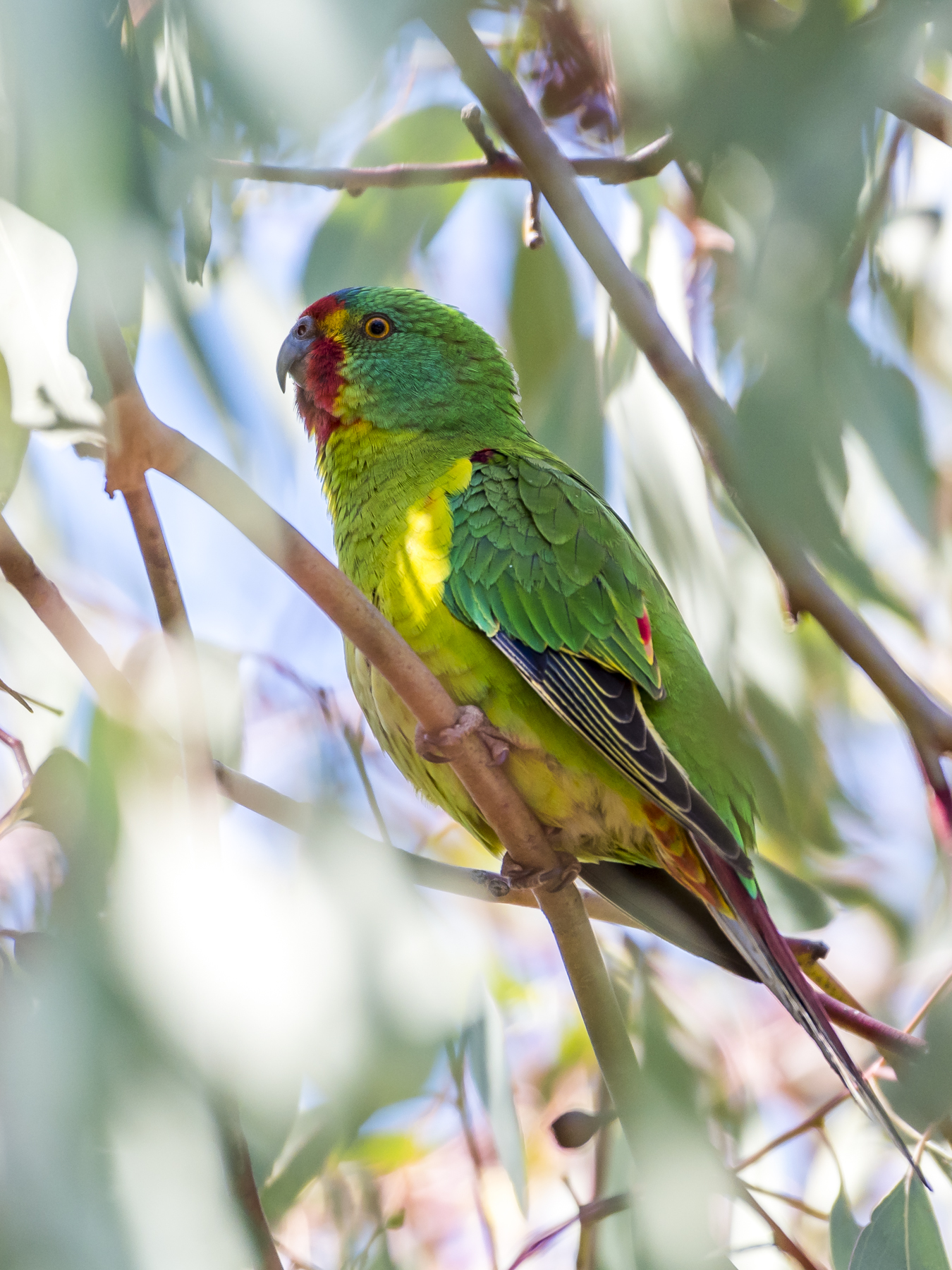
The swift parrot (''Lathamus discolor''), also known by the palawa kani name swift waylitja, is a species of broad-tailed parrot, found only in southeastern Australia. The species breeds in Tasmania during the summer and migrates north to southeastern mainland Australia from Griffith, New South Wales, Griffith-Warialda, New South Wales, Warialda in New South Wales and west to Adelaide in the winter. It is a nomadic migrant, and it settles in an area only when there is food available. The Swift Parrot was voted 2023 Bird of the Year in ''Guardian Australia, The Guardian Australia'' and BirdLife Australia's biennial poll. The species is critically endangered, and the severe predation by introduced sugar gliders (''Petaurus breviceps'') on breeding females and nests in some locations has demonstrated an unexpected but potentially serious new threat. Genetic evidence for the effective population size suggests that the minimum potential population size is now around 300–500 indivi ... [...More Info...] [...Related Items...] OR: [Wikipedia] [Google] [Baidu] |
South-east Tasmania Important Bird Area
The South-east Tasmania Important Bird Area encompasses much of the land retaining forest and woodland habitats, suitable for breeding swift parrots and forty-spotted pardalotes, from Orford to Recherche Bay in south-eastern Tasmania, Australia. Features and location This large Important Bird Area (IBA) comprises wet and dry eucalypt forests containing old growth Tasmanian blue gums or black gums, and grassy manna gum woodlands, as well as suburban residential centres and farmland where they retain large flowering, and adjacent hollow-bearing, trees. Key tracts of forest within the IBA include Wielangta, the Meehan and Wellington Ranges, and the Tasman Peninsula. The area has been identified by BirdLife International as an IBA because it contains almost all the breeding habitat of the endangered swift parrot on the Tasmanian mainland, several populations of the endangered forty-spotted pardalote, as well as good numbers of flame and pink robins, striated fieldwrens and p ... [...More Info...] [...Related Items...] OR: [Wikipedia] [Google] [Baidu] |
Basalt
Basalt (; ) is an aphanite, aphanitic (fine-grained) extrusive igneous rock formed from the rapid cooling of low-viscosity lava rich in magnesium and iron (mafic lava) exposed at or very near the planetary surface, surface of a terrestrial planet, rocky planet or natural satellite, moon. More than 90% of all volcanic rock on Earth is basalt. Rapid-cooling, fine-grained basalt is chemically equivalent to slow-cooling, coarse-grained gabbro. The eruption of basalt lava is observed by geologists at about 20 volcanoes per year. Basalt is also an important rock type on other planetary bodies in the Solar System. For example, the bulk of the plains of volcanism on Venus, Venus, which cover ~80% of the surface, are basaltic; the lunar mare, lunar maria are plains of flood-basaltic lava flows; and basalt is a common rock on the surface of Mars. Molten basalt lava has a low viscosity due to its relatively low silica content (between 45% and 52%), resulting in rapidly moving lava flo ... [...More Info...] [...Related Items...] OR: [Wikipedia] [Google] [Baidu] |


