|
Faro River
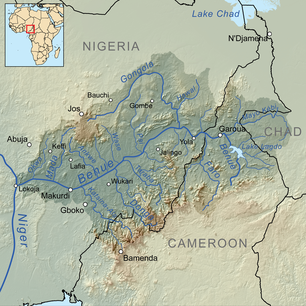
The Faro River is a river that flows over the Nigeria–Cameroon border in Africa. Its source is on the Adamawa Plateau, which lies southeast of Ngaoundéré, in the Adamawa Region of Cameroon. A tributary of the Benue River, they meet on the border. See also *Communes of Cameroon The Divisions of Cameroon are the third-level units of administration in Cameroon. They are organised by divisions and sub divisions of each province (now Regions). As of 2005 (and since 1996) there are 2 urban communities (Douala and Ya ... References Faro River Rivers of Nigeria Rivers of Cameroon {{Cameroon-river-stub Adamawa State ... [...More Info...] [...Related Items...] OR: [Wikipedia] [Google] [Baidu] |
Nigeria
Nigeria, officially the Federal Republic of Nigeria, is a country in West Africa. It is situated between the Sahel to the north and the Gulf of Guinea in the Atlantic Ocean to the south. It covers an area of . With Demographics of Nigeria, a population of more than 230 million, it is the List of African countries by population, most populous country in Africa, and the List of countries and dependencies by population, world's sixth-most populous country. Nigeria borders Niger in Niger–Nigeria border, the north, Chad in Chad–Nigeria border, the northeast, Cameroon in Cameroon–Nigeria border, the east, and Benin in Benin–Nigeria border, the west. Nigeria is a Federation, federal republic comprising 36 States of Nigeria, states and the Federal Capital Territory, Nigeria, Federal Capital Territory, where its capital, Abuja, is located. The List of Nigerian cities by population, largest city in Nigeria by population is Lagos, one of the largest List of largest cities, metr ... [...More Info...] [...Related Items...] OR: [Wikipedia] [Google] [Baidu] |
Cameroon
Cameroon, officially the Republic of Cameroon, is a country in Central Africa. It shares boundaries with Nigeria to the west and north, Chad to the northeast, the Central African Republic to the east, and Equatorial Guinea, Gabon, and the Republic of the Congo to the south. Its coastline lies on the Bight of Biafra, part of the Gulf of Guinea, and the Atlantic Ocean. Due to its strategic position at the crossroads between West Africa and Central Africa, it has been categorized as being in both camps. Cameroon's population of nearly 31 million people speak 250 native languages, in addition to the national tongues of English and French, or both. Early inhabitants of the territory included the Sao civilisation around Lake Chad and the Baka people (Cameroon and Gabon), Baka hunter-gatherers in the southeastern rainforest. Portuguese discoveries, Portuguese explorers reached the coast in the 15th century and named the area ''Rio dos Camarões'' (''Shrimp River''), which became ''C ... [...More Info...] [...Related Items...] OR: [Wikipedia] [Google] [Baidu] |
Africa
Africa is the world's second-largest and second-most populous continent after Asia. At about 30.3 million km2 (11.7 million square miles) including adjacent islands, it covers 20% of Earth's land area and 6% of its total surface area.Sayre, April Pulley (1999), ''Africa'', Twenty-First Century Books. . With nearly billion people as of , it accounts for about of the world's human population. Demographics of Africa, Africa's population is the youngest among all the continents; the median age in 2012 was 19.7, when the worldwide median age was 30.4. Based on 2024 projections, Africa's population will exceed 3.8 billion people by 2100. Africa is the least wealthy inhabited continent per capita and second-least wealthy by total wealth, ahead of Oceania. Scholars have attributed this to different factors including Geography of Africa, geography, Climate of Africa, climate, corruption, Scramble for Africa, colonialism, the Cold War, and neocolonialism. Despite this lo ... [...More Info...] [...Related Items...] OR: [Wikipedia] [Google] [Baidu] |
Adamawa Plateau
The Adamawa Plateau () is a plateau region in west-central Africa stretching from south-eastern Nigeria through north-central Cameroon ( Adamawa and North Provinces) to the Central African Republic. The part of the plateau that lies in Nigeria is more popularly known as Gotel Mountains. The Adamawa Plateau is the source of many waterways, including the Benue River. The average elevation is about , but elevations can reach as high as . It is important for its deposits of bauxite. The vegetation is mostly savanna. The endangered toad '' Amietophrynus djohongensis'' is known to exist in the wild only in the Cameroonian part of the Adamawa Plateau. The plateau is sparsely populated, and cattle raising is the main occupation in the area. The province and plateau were named after Fulani Muslim Muslims () are people who adhere to Islam, a Monotheism, monotheistic religion belonging to the Abrahamic religions, Abrahamic tradition. They consider the Quran, the foundational rel ... [...More Info...] [...Related Items...] OR: [Wikipedia] [Google] [Baidu] |
Ngaoundéré
Ngaoundéré or N'Gaoundéré (Fula: N'gamdere, , 𞤲'𞤺𞤢𞤥𞤣𞤫𞥅𞤪𞤫𞥅) is the capital of the Adamawa Region of Cameroon. It had a population of 152,700 at the 2005 census. According to the film ''Les Mairuuwas – Maitre de l'eau'' produced by the University of Tromsø, the population has rapidly risen to 1,000,000 (as of October 2016) owing to mass immigration from the Central African Republic and the perceived danger from Boko Haram in northern Cameroon. The city lies at the northern end of Rail transport in Cameroon, the railway to Yaoundé and is also home to Ngaoundéré Airport. Attractions in the city include the Lamido Palace and the Lamido Grand Mosque. The town is named after a nearby mountain on its Ngaoundere Plateau, eponymous plateau; the mountain's name is the Mbum language, Mbum word for "belly button, navel mountain". "Ngaou" mean mountain in Mbum language, Mbum, and "Ndare" mean navel in Mbum language, Mbum language. Because of this some peo ... [...More Info...] [...Related Items...] OR: [Wikipedia] [Google] [Baidu] |
Adamawa Region
The Adamawa Region () is a constituent region of the Cameroon, Republic of Cameroon. It borders the Centre Region (Cameroon), Centre and East Region (Cameroon), East regions to the south, the Northwest Region (Cameroon), Northwest and West Region (Cameroon), West regions to the southwest, Nigeria to the west, the Central African Republic (CAR) to the east, and the North Region (Cameroon), North Region to the north. This mountainous area forms the barrier between Cameroon's forested south and savanna north. At almost 64,000 km2 in land area, the Adamawa is the third largest of regions of Cameroon, Cameroon's ten regions. The land is rugged and sparsely populated, however, as most is devoted to the rearing of cattle. The Islam, Muslim Fula people, Fulbe (Fulani) form the major ethnic group, though Tikar, Gbaya people, Gbaya, and other peoples are present in lesser numbers. History Early population movements The Adamawa's oldest populations were various Paleo-Sudanese peo ... [...More Info...] [...Related Items...] OR: [Wikipedia] [Google] [Baidu] |
Benue River
Benue River (), previously known as the Chadda River or Tchadda, is a major tributary of the Niger River. The size of its catchment basin is 319,000 km2 (123,000 sq mi). Almost its entire length of Approximation, approximately is navigable during the summer months. As a result, it is an important transportation route in the regions through which it flows. The name ''Benue State, Benue'' comes from ''Binuwe,'' meaning 'Mother of Waters’ in the Bata language, Batta language. Geography The Benue rises in the Adamawa Plateau of northern Cameroon, from where it flows west, and through the town of Garoua and Lagdo Reservoir, into Nigeria south of the Mandara mountains, and through Jimeta, Ibi, Nigeria, Ibi and Makurdi before meeting the Niger River at Lokoja. Large tributaries are the Faro River, the Gongola River and the Mayo Kébbi, which connects it with the Logone River (part of the Lake Chad system) during floods. Other tributaries include Taraba River and River Katsina Ala ... [...More Info...] [...Related Items...] OR: [Wikipedia] [Google] [Baidu] |
Communes Of Cameroon
The Divisions of Cameroon are the third-level units of administration in Cameroon. They are organised by divisions and sub divisions of each province (now Regions). As of 2005 (and since 1996) there are 2 urban communities (Douala and Yaoundé) divided into 11 urban districts (5 in Douala and 6 in Yaounde), 9 towns with special status (Nkongsamba, Bafoussam, Bamenda, Limbe, Cameroon, Limbe, Edéa, Ebolowa, Garoua, Maroua and Kumba), 11 urban communes and 305 rural communes. The councils are headed by mayors and municipal councillors who are elected. The councils have a responsibility in principle for the management of local affairs under the supervision of the State. Under Cameroonian law, the councils provide and regulate administrative, economic and social development, define and enforce work practices to increase efficiency and improve the quality of services, promote training and retraining of municipal staff. The ballot for the election of municipal elections is a ... [...More Info...] [...Related Items...] OR: [Wikipedia] [Google] [Baidu] |
Rivers Of Nigeria
This is a list of rivers of Nigeria. This list is arranged by drainage basin and from west to east, with respective tributaries indented under each larger stream's name. Atlantic Ocean *Ouémé River * Okpara River *Ogun RiverOyan River* Ofiki River * Ona River (Awna River) * Ogunpa River *Osun River *Erinle River * Ostia River * Oba River * Omi Osun * Benin River *Osse River *Niger River *Escravos River (distributary) * Forcados River (distributary) * Chanomi Creek (distributary) *Nun River (distributary) * New Calabar River (distributary) * Anambra River *Benue River * Okwa River * Mada River * Katsina Ala River * Menchum River * Ankwe River * Donga River * Bantaji River (Suntai River) * Wase River *Taraba River * Kam River *Pai River * Gongola River * Hawal River * Faro River * Gurara River *Kaduna River * Mariga River * Tubo River * Galma River (Nigeria) * Moshi River * Teshi River *Oli River * Malendo River * Sokoto River *Ka River * Zamfara River * Gaminda River * Rima River * ... [...More Info...] [...Related Items...] OR: [Wikipedia] [Google] [Baidu] |
Rivers Of Cameroon
This is a list of rivers in Cameroon. This list is arranged by drainage basin, with respective tributaries indented under each larger stream's name. Gulf of Guinea *''Niger River (Nigeria)'' **Benue River ***Katsina Ala River ****Menchum River ***Donga River ***Faro River ****Déo River ***Mayo Kébbi *Cross River (Nigeria), Cross River (Manyu River) **Akwayafe River *Rio del Ray *Meme River *Mungo River (Cameroon), Mungo River *Wouri River **Makombé River **Nkam River *Dibamba River *Sanaga River **Mbam River ***Ndjim River ***Noun River (Cameroon), Noun River ***Kim River (Cameroon), Kim River **Lom River (Cameroon), Lom River *** Pangar River **Djeréme River *Nyong River *Lokundje River *Campo River (Ntem River) Atlantic Ocean *''Ogooué River (Gabon)'' **''Ivindo River (Gabon)'' ***Aïna River (Ayina River) ****Lélé River *''Congo River (Republic of the Congo)'' **Sangha River ***Dja River (Ngoko River) ****Boumba River ****Sangha River ****Ngoko River ***Kadéï River ** ... [...More Info...] [...Related Items...] OR: [Wikipedia] [Google] [Baidu] |


