|
Donnersberg
The Donnersberg ("thunder mountain") is the highest peak of the Palatinate (german: Pfalz) region of Germany. The mountain lies between the towns of Rockenhausen and Kirchheimbolanden, in the Donnersbergkreis district, which is named after the mountain. The highway A63 runs along the southern edge of the Donnersberg. European walking route E8 runs across the mountain. The highest point of the Donnersberg is the rock ''Königstuhl'' ("king's seat") at 687 metres above sea level. The mountain has a diameter of about 7 kilometres and covers an area of some 2,400 hectares. The Donnersberg was formed by volcanic activity during the Permian, in the transition period between the lower and upper Rotliegend strata. The name Donnersberg is thought to refer to Donar, the Germanic god of thunder, a theory supported by the fact that the Romans dubbed the Donnersberg ''Mons Jovis'' after their god of thunder, Jupiter. According to other theories, the name of the mountain was derived from ... [...More Info...] [...Related Items...] OR: [Wikipedia] [Google] [Baidu] |
North Palatine Uplands
The North Palatine Uplands (german: Nordpfälzer Bergland), sometimes shortened to Palatine Uplands (''Pfälzer Bergland''), is a low mountain range and landscape unit in the German state of Rhineland-Palatinate and belongs mainly to the Palatinate region. It is part of the Saar-Nahe Uplands. Geography Location The North Palatine Uplands lie – roughly stated – between St. Wendel in the state of Saarland to the west and three towns belonging to Rhineland-Palatinate: Alzey to the east, Kaiserslautern to the south and Bad Kreuznach to the north, although these towns are not actually within the region itself. The North Palatine Uplands thus links the landscapes of the Palatine Forest, Saar-Hunsrück Nature Park, Naheland and Rheinhessen. To the northwest its boundary with Naheland is not always clear. A rough guide is the heavily folded ridge north of the Glan river with a height different of as much as 300 metres in place. The North Palatine Uplands fall ma ... [...More Info...] [...Related Items...] OR: [Wikipedia] [Google] [Baidu] |
Donnersbergkreis
The Donnersbergkreis is a district (''Kreis'') in the middle of Rhineland-Palatinate, Germany. Neighboring districts are Bad Kreuznach, Alzey-Worms, Bad Dürkheim, Kaiserslautern, Kusel. History The district was created in 1969 by merging the districts Kirchheimbolanden and Rockenhausen. Geography The district is located around the highest mountain of the Palatinate, the ''Donnersberg'' with 687 m above sea level. Coat of arms Both of the districts merged into the Donnersbergkreis had a wheel in their coat of arms, which are now also shown in the coat of arms of the new district. On the left is the red wheel of the Lords of Bolanden, taken from the Kirchheim coat of arms. The blue wheel on the right is the wheel of the Lords of Falkenstein, taken from the Rockenhausen coat of arms. The green field on the bottom with the peak symbolizes the Donnersberg, the highest elevation in the district, and the sun the importance of the sunny plains for viticulture Viticulture (from the ... [...More Info...] [...Related Items...] OR: [Wikipedia] [Google] [Baidu] |
Steinbach Am Donnersberg
Steinbach am Donnersberg is a municipality in the Donnersbergkreis district, in Rhineland-Palatinate Rhineland-Palatinate ( , ; german: link=no, Rheinland-Pfalz ; lb, Rheinland-Pfalz ; pfl, Rhoilond-Palz) is a western state of Germany. It covers and has about 4.05 million residents. It is the ninth largest and sixth most populous of the ..., Germany. The current mayor is Susanne Röß, elected in 2019. References Donnersbergkreis {{Donnersbergkreis-geo-stub ... [...More Info...] [...Related Items...] OR: [Wikipedia] [Google] [Baidu] |
Rockenhausen
Rockenhausen is a town in the Donnersbergkreis, in Rhineland-Palatinate, Germany. It is situated on the river Alsenz, approx. north of Kaiserslautern. Rockenhausen is the seat of the ''Verbandsgemeinde'' ("collective municipality") Nordpfälzer Land. The town consists the villages Marienthal, Dörnbach, and Rockenhausen itself. History Rockenhausen received its town charter in 1332. At that time subordinated to the Raugrafen, the town belonged to the Electoral Palatinate from 1457. During the Thirty Years' War, it was almost completely destroyed, as were almost all other villages in the region. After 1792 the region was occupied by French troops in the First Revolutionary War and annexed after the peace of Campo Formio (1797). From 1798 to 1814 Rockenhausen belonged to the French department Donnersberg and was the capital (chef-lieu) of the canton Rockenhausen. Due to the agreements made at the Congress of Vienna (1815) and an exchange contract with Austria, the region became p ... [...More Info...] [...Related Items...] OR: [Wikipedia] [Google] [Baidu] |
Kirchheimbolanden
Kirchheimbolanden (), the capital of Donnersbergkreis, is a town in Rhineland-Palatinate, south-western Germany. It is situated approximately 25 km west of Worms, and 30 km north-east of Kaiserslautern. The first part of the name, ''Kirchheim'', dates back to 774. It became a town in 1368, and the Sponheim family improved its security with many towers and walls. William, Duke of Nassau, ancestor of the royal families of Belgium, Sweden, Denmark and Norway, and of the grand-ducal family of Luxembourg, was born in Kirchheimbolanden. It was also ruled by the First French Empire between 1792 and 1814, before passing to the Kingdom of Bavaria in 1815. It was a rural district centre in the ''Rheinkreis'', which was renamed ''Pfalz'' ( Palatinate) in 1835. Geography Location Kirchheimbolanden lies in the Palatinate at the transition point of the Nordpfälzer Bergland to the Alzeyer Hügelland bordering to the east. The city centre is located about four kilometres ( ... [...More Info...] [...Related Items...] OR: [Wikipedia] [Google] [Baidu] |
Ruppertsecken Castle
Ruppertsecken is a municipality in the Donnersbergkreis district, in Rhineland-Palatinate Rhineland-Palatinate ( , ; german: link=no, Rheinland-Pfalz ; lb, Rheinland-Pfalz ; pfl, Rhoilond-Palz) is a western state of Germany. It covers and has about 4.05 million residents. It is the ninth largest and sixth most populous of the ..., Germany. References Municipalities in Rhineland-Palatinate Donnersbergkreis {{Donnersbergkreis-geo-stub ... [...More Info...] [...Related Items...] OR: [Wikipedia] [Google] [Baidu] |
Falkenstein Castle (Palatinate)
Falkenstein Castle (german: Burg Falkenstein) is a ruined hill castle (imperial castle) dating to the Middle Ages. It is situated above the eponymous village of Falkenstein on the Donnersberg, the highest point in the Palatinate region, which rises within the German state of Rhineland-Palatinate. History ''For the political history see County of Falkenstein'' Falkenstein is first recorded in 1135 as the castle of the lords of Falkenstein, a branch of the lords of Bolanden. It is mentioned again in 1233 in the possession of Philip I, the Lord of Falkenstein, the Imperial Chamberlain ('' Reichskämmerer'') and ''burgvogt'' at Trifels Castle, where the Imperial Regalia were guarded. After the death of the imperial chamberlain of Münzenberg Philip I took over the office. In 1255 he inherited the '' Landvogtei'' in the Wetterau. Lich was later the centre of the territory of Philip I of Falkenstein. In the mid-14th century the Falkensteins built New Falkenstein in the Taunus regi ... [...More Info...] [...Related Items...] OR: [Wikipedia] [Google] [Baidu] |
Wildenstein Castle (Palatinate)
Wildenstein Castle (german: Burg Wildenstein) is a ruined hill castle on a hill, {{Höhe, 486, DE-NN, link=true, in the Wildenstein valley (''Wildensteiner Tal''), hidden in a wood at the foot of the Donnersberg near Dannenfels in the county of Donnersbergkreis in the German state of Rhineland-Palatinate. The castles is of the motte and bailey A motte-and-bailey castle is a European fortification with a wooden or stone keep situated on a raised area of ground called a motte, accompanied by a walled courtyard, or bailey, surrounded by a protective ditch and palisade. Relatively easy t ... type. Together with the three other ruined castles of Falkenstein, Hohenfels and Tannenfels, it forms the ring of the "Donnersberg Castles".Information board at the castle, viewed 2009 References External links Wildenstein Castle at pfalzlexikon.de Castles in Rhineland-Palatinate Heritage sites in Rhineland-Palatinate Donnersbergkreis ... [...More Info...] [...Related Items...] OR: [Wikipedia] [Google] [Baidu] |
Tannenfels Castle (Palatinate)
Tannenfels Castle (german: Burg Tannenfels) is a ruined hill castle of the motte and bailey type which stands at a height of above the village of Dannenfels on the Donnersberg hill in the county of Donnersbergkreis in the German state of Rhineland-Palatinate. History Along with the Barony (''Herrschaft'') of Kirchheim, the castle belonged to the lords of Bolanden. In the late 13th century most of the territory was inherited by the counts of Sponheim. They founded a family line, ''Sponheim-Bolanden-Dannenfels'', which resided here. The motte and bailey castle is first recorded in 1330, when Count Philip of Sponheim-Bolanden-Dannenfels and his wife, Lisa of Katzenelnbogen endowed a chapel in the castle. Castellan (''Burgmann'') Bechtholf of Beckingen was installed in the castle in 1364. Around 1368 Henry II of Sponheim-Bolanden moved his family seat to nearby Kirchheimbolanden. After his death in 1393, the castle went via his granddaughter to the counts of Nassau-Saarbrücke ... [...More Info...] [...Related Items...] OR: [Wikipedia] [Google] [Baidu] |
Nordpfalz
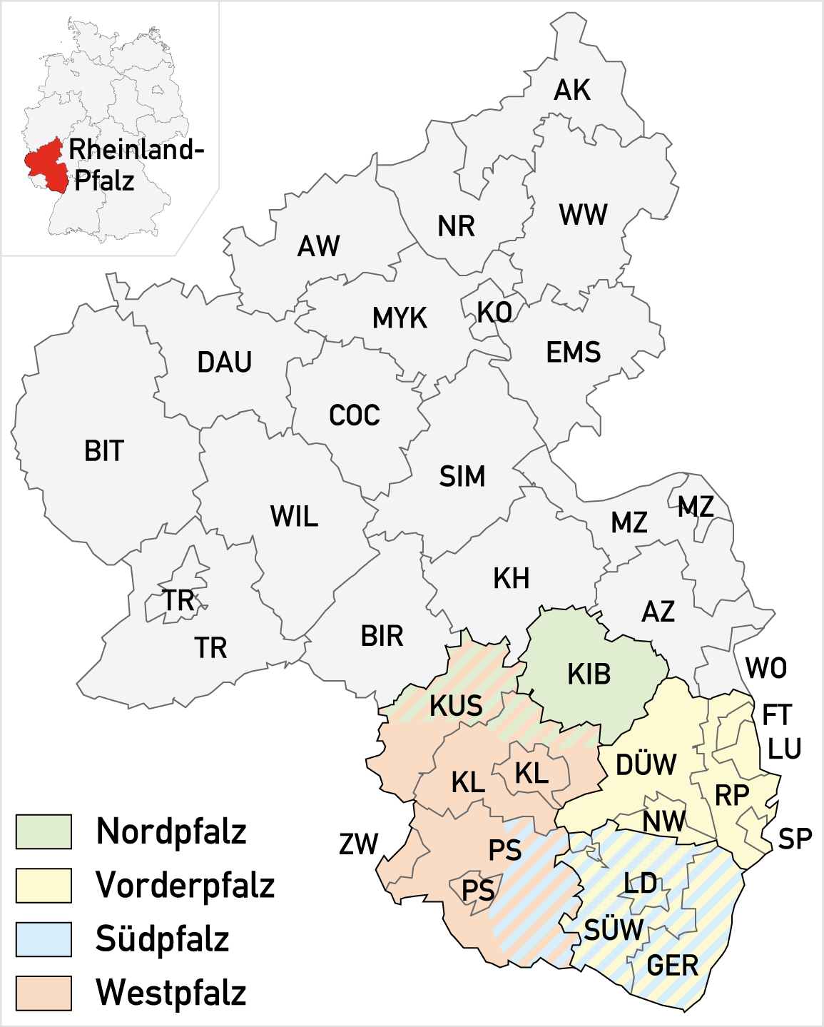
North Palatinate''Das Ende des Zweiten Weltkrieges in der Nordpfalz'' by Timo Scherne, Nordpfälzer Geschichtsverein, 2006. (german: Nordpfalz) is a region in southwest Germany with an area of just 650 km², making it the smallest landscape in the Palatinate region of the German state of Rhineland-Palatinate. Geography As its name suggests, the North Palatinate forms the northern part of the Palatinate. Almost its entire area is also part of the North Palatine Uplands, dominated by the Donnersberg massif with a height of . The other regions of the Palatinate are Anterior Palatinate, South Palatinate and West Palatinate. Towns The North Palatinate is only sparsely populated. The three largest towns all have fewer than 10,000 inhabitants: * Eisenberg * Kirchheimbolanden * Rockenhausen Rockenhausen is a town in the Donnersbergkreis, in Rhineland-Palatinate, Germany. It is situated on the river Alsenz, approx. north of Kaiserslautern. Rockenhausen is the seat of th ... [...More Info...] [...Related Items...] OR: [Wikipedia] [Google] [Baidu] |
Hohenfels Castle (Palatinate)
Hohenfels Castle (german: Burg Hohenfels) is a ruined hill castle at a height of , in the ''Beutelfels'' Nature Reserve north of the village of Imsbach in the county of Donnersbergkreis in the German state of Rhineland-Palatinate. The castle may be reached via a steep footpath from the visitor mine of ''Weiße Grube'' in the valley of ''Langental''. The path passes the "Iron Man" monument ('' Eiserner Mann''). History There are several clues that the road called in the records the Old Rockenhausen Road (''alte Rockenhauser Straße''), which ran from the area of Hahnweilerhof, continued past Hohenfels Castle in the direction of Falkenstein and Rockenhausen to Bad Kreuznach, had existed since Roman times. In 1820 a Roman hoard of 28 coins was found, which were dated to about the year 340 AD. Because there is also evidence of Roman mining activity in the deeply incised Langental valley, it is highly probable that there was a Roman fortification or road station in the area around Ho ... [...More Info...] [...Related Items...] OR: [Wikipedia] [Google] [Baidu] |
Palatinate (region)
The Palatinate (german: Pfalz; Palatine German: ''Palz'') is a region of Germany. In the Middle Ages it was known as the Rhenish Palatinate (''Rheinpfalz'') and Lower Palatinate (''Unterpfalz''), which strictly speaking designated only the western part of the Electorate of the Palatinate (''Kurfürstentum Pfalz''), as opposed to the Upper Palatinate (''Oberpfalz''). It occupies roughly the southernmost quarter of the German federal state of Rhineland-Palatinate (''Rheinland-Pfalz''), covering an area of with about 1.4 million inhabitants. Its residents are known as Palatines (''Pfälzer''). Geography The Palatinate borders Saarland in the west, historically also comprising the state's Saarpfalz District. In the northwest, the Hunsrück mountain range forms the border with the Rhineland region. The eastern border with Hesse and the Baden region runs along the Upper Rhine river, while the left bank, with Mainz and Worms as well as the Selz basin around Alzey, belong to ... [...More Info...] [...Related Items...] OR: [Wikipedia] [Google] [Baidu] |


