|
Dyuktai Cave
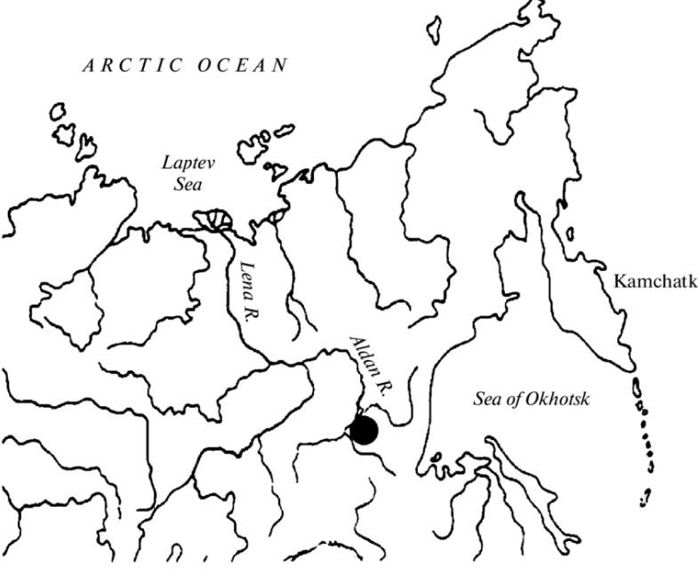
Dyuktai Cave (also called Diuktai, D'uktai, Divktai, or Duktai in Russian) is a site found in Russia's Yakutia Region (or Sakha Republic, the Sakha Republic) along the Dyuktai River in the Aldan (river), Aldan River drainage. Discovered by Yuri Mochanov in 1967, who excavated in the same year, it is located at 59.288 latitude and 132.607 longitude, a total of 317 square meters (3412 square feet) has been excavated. It's renowned for its rich archaeological deposits dating back to the Upper Paleolithic period, particularly the Last Glacial Maximum, around 30,000 to 10,000 years ago. The cave has yielded significant findings, including stone tools, bone artifacts, and evidence of early human occupation. The archaeological site is part of the Dyuktai Complex; the cave is among the youngest of the Dyuktai culture sites and was believed to be part of the Late Terminal Siberian Upper Paleolithic, Upper Paleolithic Age. Overall, the site was found to be scattered with stone tools assemblie ... [...More Info...] [...Related Items...] OR: [Wikipedia] [Google] [Baidu] |
Sakha Republic
Sakha, officially the Republic of Sakha (Yakutia), is a republics of Russia, republic of Russia, and the largest federal subject of Russia by area. It is located in the Russian Far East, along the Arctic Ocean, with a population of one million. Sakha comprises half of the area of its governing Far Eastern Federal District, and is the world's List of country subdivisions by area, largest country subdivision, covering over 3,083,523 square kilometers (1,190,555 sq mi). ''Sakha'' following regular sound changes in the course of development of the Yakut language) as the Evenk and Yukaghir exonyms for the Yakuts. It is pronounced as ''Haka'' by the Dolgans, Dolgan language, whose language is a close relative of the Yakut language.Victor P. Krivonogov, "The Dolgans’Ethnic Identity and Language Processes." ''Journal of Siberian Federal University'', Humanities & Social Sciences 6 (2013 6) 870–888. Geography * ''Borders'': ** ''internal'': Chukotka Autonomous Okrug (660 km) ( ... [...More Info...] [...Related Items...] OR: [Wikipedia] [Google] [Baidu] |
Aldan (river)
The Aldan ( Sakha and ) is the second-longest right tributary of the Lena in the Sakha Republic in eastern Siberia Siberia ( ; , ) is an extensive geographical region comprising all of North Asia, from the Ural Mountains in the west to the Pacific Ocean in the east. It has formed a part of the sovereign territory of Russia and its predecessor states ....Алдан (река в Якут. АССР) Great Soviet Encyclopedia The river is long, of which around is navigable. It has a drainage basin of . The river was part of the Siberian River Routes, River Route to Okhotsk. In 1639 Ivan Moskvitin ascended the rivers Aldan and Maya (Aldan), Maya and crossed to the Ulya River, Ulya to reach the Sea of Okhotsk. Its Drainage basin, basin is known for gold and for Cambrian fossils. |
Yuri Mochanov
Yuri Mochanov (8 November 1934 – 20 October 2020) was a Russian archaeologist. Biography Mochanov graduated from Leningrad State University in 1957 with a degree in history. He served as Deputy Director for Science at the Institute for Humanitarian Research. He discovered Upper Paleolithic Dyuktai Culture, stone tools in Diring Yuriaj in Siberia, and 1000 different archaeological sites. In his book ''In Siberia'', author Colin Thubron Colin Gerald Dryden Thubron (born 14 June 1939) is a British travel writer and novelist. In 2008, ''The Times'' ranked him among the 50 greatest postwar British writers. He is a contributor to ''The New York Review of Books'', ''The Times'', '' ... recounted his meetings with Mochanov. References 1934 births 2020 deaths Russian archaeologists Saint Petersburg State University alumni {{Russia-archaeologist-stub ... [...More Info...] [...Related Items...] OR: [Wikipedia] [Google] [Baidu] |
Upper Paleolithic
The Upper Paleolithic (or Upper Palaeolithic) is the third and last subdivision of the Paleolithic or Old Stone Age. Very broadly, it dates to between 50,000 and 12,000 years ago (the beginning of the Holocene), according to some theories coinciding with the appearance of behavioral modernity in early modern humans. It is followed by the Mesolithic. Anatomically modern humans (i.e. ''Homo sapiens'') are believed to have emerged in Africa around 300,000 years ago. It has been argued by some that their ways of life changed relatively little from that of archaic humans of the Middle Paleolithic, until about 50,000 years ago, when there was a marked increase in the diversity of Artefact (archaeology), artefacts found associated with modern human remains. This period coincides with the most common date assigned to early human migrations, expansion of modern humans from Africa throughout Asia and Eurasia, which may have contributed to the Neanderthal extinction, extinction of th ... [...More Info...] [...Related Items...] OR: [Wikipedia] [Google] [Baidu] |
Late Pleistocene
The Late Pleistocene is an unofficial Age (geology), age in the international geologic timescale in chronostratigraphy, also known as the Upper Pleistocene from a Stratigraphy, stratigraphic perspective. It is intended to be the fourth division of the Pleistocene Epoch within the ongoing Quaternary Period. It is currently defined as the time between 129,000 and c. 11,700 years ago. The late Pleistocene equates to the proposed Tarantian Age of the geologic time scale, preceded by the officially ratified Chibanian (commonly known as the Middle Pleistocene). The beginning of the Late Pleistocene is the transition between the end of the Penultimate Glacial Period and the beginning of the Last Interglacial around 130,000 years ago (corresponding with the beginning of Marine Isotope Stage 5). The Late Pleistocene ends with the termination of the Younger Dryas, some 10th millennium BC, 11,700 years ago when the Holocene Epoch began. The term Upper Pleistocene is currently in use as a p ... [...More Info...] [...Related Items...] OR: [Wikipedia] [Google] [Baidu] |
Cal BP
Before Present (BP) or "years before present (YBP)" is a time scale used mainly in archaeology, geology, and other scientific disciplines to specify when events occurred relative to the origin of practical radiocarbon dating in the 1950s. Because the "present" time changes, standard practice is to use 1January 1950 as the commencement date (epoch) of the age scale, with 1950 being labelled as the "standard year". The abbreviation "BP" has been interpreted retrospectively as "Before Physics", which refers to the time before nuclear weapons testing artificially altered the proportion of the carbon isotopes in the atmosphere, which scientists must account for when using radiocarbon dating for dates of origin that may fall after this year. In a convention that is not always observed, many sources restrict the use of BP dates to those produced with radiocarbon dating; the alternative notation "RCYBP" stands for the explicit "radio carbon years before present". Usage The BP scale is so ... [...More Info...] [...Related Items...] OR: [Wikipedia] [Google] [Baidu] |
Strata 7a
In geology and related fields, a stratum (: strata) is a layer of rock or sediment characterized by certain lithologic properties or attributes that distinguish it from adjacent layers from which it is separated by visible surfaces known as either '' bedding surfaces'' or ''bedding planes''.Salvador, A. ed., 1994. ''International stratigraphic guide: a guide to stratigraphic classification, terminology, and procedure. 2nd ed.'' Boulder, Colorado, The Geological Society of America, Inc., 215 pp. . Prior to the publication of the International Stratigraphic Guide, older publications have defined a stratum as being either equivalent to a single bed or composed of a number of beds; as a layer greater than 1 cm in thickness and constituting a part of a bed; or a general term that includes both ''bed'' and ''lamina''.Neuendorf, K.K.E., Mehl, Jr., J.P., and Jackson, J.A. , eds., 2005. ''Glossary of Geology'' 5th ed. Alexandria, Virginia, American Geological Institute. 779 pp. . R ... [...More Info...] [...Related Items...] OR: [Wikipedia] [Google] [Baidu] |
Stratigraphic Unit
A stratigraphic unit is a volume of rock of identifiable origin and relative age range that is defined by the distinctive and dominant, easily mapped and recognizable petrographic, lithologic or paleontologic features ( facies) that characterize it. Units must be ''mappable'' and ''distinct'' from one another, but the contact need not be particularly distinct. For instance, a unit may be defined by terms such as "when the sandstone component exceeds 75%". Lithostratigraphic units Sequences of sedimentary and volcanic rocks are subdivided on the basis of their shared or associated lithology. Formally identified lithostratigraphic units are structured in a hierarchy of lithostratigraphic rank, higher rank units generally comprising two or more units of lower rank. Going from smaller to larger in rank, the main lithostratigraphic ranks are bed, member, formation, group and supergroup. Formal names of lithostratigraphic units are assigned by geological surveys. Units of form ... [...More Info...] [...Related Items...] OR: [Wikipedia] [Google] [Baidu] |
Strata 7a 2
In geology and related fields, a stratum (: strata) is a layer of rock or sediment characterized by certain lithologic properties or attributes that distinguish it from adjacent layers from which it is separated by visible surfaces known as either '' bedding surfaces'' or ''bedding planes''.Salvador, A. ed., 1994. ''International stratigraphic guide: a guide to stratigraphic classification, terminology, and procedure. 2nd ed.'' Boulder, Colorado, The Geological Society of America, Inc., 215 pp. . Prior to the publication of the International Stratigraphic Guide, older publications have defined a stratum as being either equivalent to a single bed or composed of a number of beds; as a layer greater than 1 cm in thickness and constituting a part of a bed; or a general term that includes both ''bed'' and ''lamina''.Neuendorf, K.K.E., Mehl, Jr., J.P., and Jackson, J.A. , eds., 2005. ''Glossary of Geology'' 5th ed. Alexandria, Virginia, American Geological Institute. 779 pp. . R ... [...More Info...] [...Related Items...] OR: [Wikipedia] [Google] [Baidu] |
French National Centre For Scientific Research
The French National Centre for Scientific Research (, , CNRS) is the French state research organisation and is the largest fundamental science agency in Europe. In 2016, it employed 31,637 staff, including 11,137 tenured researchers, 13,415 engineers and technical staff, and 7,085 contractual workers. It is headquartered in Paris and has administrative offices in Brussels, Beijing, Tokyo, Singapore, Washington, D.C., Bonn, Moscow, Tunis, Johannesburg, Santiago de Chile, Israel, and New Delhi. Organization The CNRS operates on the basis of research units, which are of two kinds: "proper units" (UPRs) are operated solely by the CNRS, and Joint Research Unit, Joint Research Units (UMRs – ) are run in association with other institutions, such as List of colleges and universities in France, universities or INSERM. Members of Joint Research Units may be either CNRS researchers or university employees (Academic ranks in France, ''maîtres de conférences'' or ''professeurs''). Each ... [...More Info...] [...Related Items...] OR: [Wikipedia] [Google] [Baidu] |


