|
Dyke, Virginia
Dyke is an unincorporated community in Greene County, Virginia, United States. It is located along Virginia Secondary State Route 810. In 2020, the small store in Dyke was replaced with a larger one and a gas station. It is located near Saint George, Virginia and The Blue Ridge School. Estes Farm was added to the National Register of Historic Places in 2006. Binghams United Methodist Church, formerly known as Austin's Meeting House, established in 1796, is on the north side of the Lynch River. Rev. John Gibson, a farmer and landowner, preached there for years. History The region was settled in the southwestern part of what was then Orange County in the 18th century, becoming part of Greene County in 1838 when it was formed from the western part of Orange. Dyke is believed to have been named in the 19th century after a family of enslaved people with roots in West Africa who lived here. In 1860, nearly 40 percent of the more than 5,000 inhabitants in Greene County were ... [...More Info...] [...Related Items...] OR: [Wikipedia] [Google] [Baidu] |
Slavery
Slavery is the ownership of a person as property, especially in regards to their labour. Slavery typically involves compulsory work, with the slave's location of work and residence dictated by the party that holds them in bondage. Enslavement is the placement of a person into slavery, and the person is called a slave or an enslaved person (see ). Many historical cases of enslavement occurred as a result of breaking the law, becoming indebted, suffering a military defeat, or exploitation for cheaper labor; other forms of slavery were instituted along demographic lines such as race or sex. Slaves would be kept in bondage for life, or for a fixed period of time after which they would be granted freedom. Although slavery is usually involuntary and involves coercion, there are also cases where people voluntarily enter into slavery to pay a debt or earn money due to poverty. In the course of human history, slavery was a typical feature of civilization, and existed in most socie ... [...More Info...] [...Related Items...] OR: [Wikipedia] [Google] [Baidu] |
Scuffletown, Virginia
Scuffletown is an unincorporated community in Orange County, Virginia. It lies at an elevation of 571 feet (174 m). It is located in the far northwestern section of the county, about north of Barboursville. History The community is immediately south of historical geographical points on the Rapidan River known as "Wilhoit's Mill" (also "Wilhite's Ford”) and "White's Ford" in the 19th century. The later may have been named for John White (1695-1787), the emigrant of Leicestershire, who, on July 1, 1767, expanded his land holdings on the Rapidan River as a tract of land known as the Octonia Grant was auctioned off. The westernmost boundary line of the 24,000-acre Grant is the Octonia Stone. Clerk for the sale was James Madison, Sr., father of the future president of the United States. John White bought lot #4 of this tract, an area of 356 acres, for 75 pounds. He made a cash payment of 49 pounds, and by June 22, 1769, he had paid the full price to Mr. Madison. A ford acros ... [...More Info...] [...Related Items...] OR: [Wikipedia] [Google] [Baidu] |
Ruckersville, Virginia
Ruckersville is a census-designated place (CDP) in Greene County, Virginia, United States, located in a rural area north of Charlottesville. The population as of the 2020 estimate was 1,321, a 17.7% increase from the 2010 census with 1,141. The community lies amidst hills, mountain views, trees, and farmland. It is located at the intersection of two major highways, north–south U.S. Route 29 and east–west U.S. Route 33. It was founded in 1732, by the same family that established Ruckersville, Georgia. History Ruckersville was originally founded by John Rucker in what was then Orange County. He settled east of here on Rippin's Run and named the village for his uncle, Captain John Rucker, who helped choose the site for St. Mark’s Parish Church in 1732. Several early families settled here, including John White, the emigrant of Leicestershire, who, in 1739, received a land grant from George II of Great Britain for bringing four convicts to the Colonies to work as indentured ... [...More Info...] [...Related Items...] OR: [Wikipedia] [Google] [Baidu] |
Plantation
Plantations are farms specializing in cash crops, usually mainly planting a single crop, with perhaps ancillary areas for vegetables for eating and so on. Plantations, centered on a plantation house, grow crops including cotton, cannabis, tobacco, coffee, tea, cocoa, sugar cane, opium, sisal, oil seeds, oil palms, fruits, rubber trees and forest trees. Protectionist policies and natural comparative advantage have sometimes contributed to determining where plantations are located. In modern use, the term usually refers only to large-scale estates. Before about 1860, it was the usual term for a farm of any size in the southern parts of British North America, with, as Noah Webster noted, "farm" becoming the usual term from about Maryland northward. The enslavement of people was the norm in Maryland and states southward. The plantations there were forced-labor farms. The term "plantation" was used in most British colonies but very rarely in the United Kingdom itself i ... [...More Info...] [...Related Items...] OR: [Wikipedia] [Google] [Baidu] |
Leicestershire
Leicestershire ( ) is a Ceremonial counties of England, ceremonial county in the East Midlands of England. It is bordered by Derbyshire, Nottinghamshire and Lincolnshire to the north, Rutland to the east, Northamptonshire to the south-east, Warwickshire to the south-west, and Staffordshire to the west. The city of Leicester is the largest settlement and the county town. The county has an area of and a population of one million according to 2022 estimates. Leicester is in the centre of the county and is by far the largest settlement, with a Leicester urban area, built-up area population of approximately half a million. The remainder of the county is largely rural, and the next-largest settlements are Loughborough in the north, Hinckley in the south-west, and Wigston south-east of Leicester. For Local government in England, local government purposes Leicestershire comprises a non-metropolitan county, with seven districts, and the Unitary authorities of England, unitary authority a ... [...More Info...] [...Related Items...] OR: [Wikipedia] [Google] [Baidu] |
Albemarle County, Virginia
Albemarle County is a United States county (United States), county located in the Piedmont region of Virginia, Piedmont region of the Commonwealth (U.S. state), Commonwealth of Virginia. Its county seat is Charlottesville, Virginia, Charlottesville, which is an independent city entirely surrounded by the county. Albemarle County is part of the Charlottesville metropolitan area, Charlottesville Metropolitan Statistical Area. As of the 2020 United States census, 2020 census, the population was 112,395. Albemarle County was created in 1744 from the western portion of Goochland County, Virginia, Goochland County, though portions of Albemarle were later carved out to create other counties. Albemarle County was named in honor of Willem Anne van Keppel, 2nd Earl of Albemarle. Its most famous inhabitant was Thomas Jefferson, who built his estate home, Monticello, in the county. History At the time of European encounter, the inhabitants of the area that became Albemarle County were ... [...More Info...] [...Related Items...] OR: [Wikipedia] [Google] [Baidu] |
Nortonsville, Virginia
Nortonsville is an unincorporated community in Albemarle County, Virginia. It is on the northern border of Albemarle County, near the Lynch River, which shares its border with Greene County. History The village was named for Cyprian C. Norton, who, in 1835, lent his name to the post office established here.January 7, 1834. C. C. Norton, Nortonsville, Albemarle, Virginia. U.S., Appointments of U. S. Postmasters, 1832-1971, ancestry.com The post office structure, with 21 rooms, remains from the 19th century on a property that included, at the time, a home, store, post office, doctor, dentist, schoolhouse, barber shop, blacksmith shop, garage, and working mill. The Louis Cranston Parrish family ran the post office in the 20th century. The historic Binghams United Methodist Church, established in 1796, is a half mile northeast of Nortonsville, on the north side of the Lynch River The Lynch River is a U.S. Geological Survey. National Hydrography Dataset high-resolution flowline ... [...More Info...] [...Related Items...] OR: [Wikipedia] [Google] [Baidu] |
History Of Slavery In Virginia
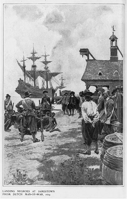
Slavery in Virginia began with the capture and enslavement of Native Americans during the early days of the English Colony of Virginia and through the late eighteenth century. They primarily worked in tobacco fields. Africans were first brought to colonial Virginia in 1619, when 20 Africans from present-day Angola arrived in Virginia aboard the ship '' The White Lion''. As the slave trade grew, enslaved people generally were forced to labor at large plantations, where their free labor made plantation owners rich. Colonial Virginia became an amalgamation of Algonquin-speaking Native Americans, English, other Europeans, and West Africans, each bringing their own language, customs, and rituals. By the eighteenth century, plantation owners were the aristocracy of Virginia. There were also a class of white people who oversaw the work of enslaved people, and a poorer class of whites that competed for work with freed blacks. Tobacco was the key export of the colony in the sevente ... [...More Info...] [...Related Items...] OR: [Wikipedia] [Google] [Baidu] |
Orange County, Virginia
Orange County is a county (United States), county located in the central Piedmont region of Virginia, Piedmont region of the Commonwealth (U.S. state), Commonwealth of Virginia. At the 2020 United States census, 2020 census, the population was 36,254. Its county seat is Orange, Virginia, Orange. Orange County includes Montpelier (Orange, Virginia), Montpelier, the estate of James Madison, the 4th President of the United States and often known as the "Father of the United States Constitution, Constitution". The county celebrated its 290th anniversary in 2024. History The area was inhabited for thousands of years by various cultures of Native Americans in the United States, indigenous peoples. At the time of European encounter, the Ontponea, a sub-group of the Siouan languages, Siouan-speaking Manahoac, lived in this Piedmont (United States), Piedmont area. The first European settlement in what was to become Orange County was Germanna, formed when Governor Alexander Spotswood s ... [...More Info...] [...Related Items...] OR: [Wikipedia] [Google] [Baidu] |
Unincorporated Area
An unincorporated area is a parcel of land that is not governed by a local general-purpose municipal corporation. (At p. 178.) They may be governed or serviced by an encompassing unit (such as a county) or another branch of the state (such as the military). There are many unincorporated communities and areas in the United States and Canada, but many countries do not use the concept of an unincorporated area. By country Argentina In Argentina, the provinces of Chubut Province, Chubut, Córdoba Province (Argentina), Córdoba, Entre Ríos Province, Entre Ríos, Formosa Province, Formosa, Neuquén Province, Neuquén, Río Negro Province, Río Negro, San Luis Province, San Luis, Santa Cruz Province, Argentina, Santa Cruz, Santiago del Estero Province, Santiago del Estero, Tierra del Fuego Province, Argentina, Tierra del Fuego, and Tucumán Province, Tucumán have areas that are outside any municipality or commune. Australia Unlike many other countries, Australia has only local go ... [...More Info...] [...Related Items...] OR: [Wikipedia] [Google] [Baidu] |


