|
Ducové
Ducové () is a municipality (village) situated in western Slovakia, near the spa town of Piešťany. It was part of the municipality Moravany nad Váhom from 1976 to 1992. The village lies under the Váh Inovec. According to the 2011 census, the municipality had 375 inhabitants. 365 of inhabitants were Slovaks and 10 others and unspecified. Etymology The name of the village is derived from ''dux-ducis'' meaning duke. ''Duka'' was also a borrowed word used by the Slavs for a person with a prominent social status. The village was known as 1348 Duchreuy, 1453 Duczev, 1521 De-chobrod, 1532, 1638 Ducibrod, 1576 Ducybrod, 1636 Duczowa, 1664 Ducó, 1667 Duczo, 1668 Duczove, 1693 Duczowa, 1753 Duczó, 1776 Duczo, 1773 Duczo, Dutzo, Duczowe, 1786 Duczo, Duczowce, 1808 Duczó, Ducow, 1863 -1918 Ducó, 1920 Ducov, Ducové, 1927 Ducové. Great Moravian Court Ducové is known for an archaeological site on the ''Kostolec'' hill, where a Great Moravian fortified settlement has been unearthed. ... [...More Info...] [...Related Items...] OR: [Wikipedia] [Google] [Baidu] |
Great Moravia
Great Moravia (; , ''Meghálī Moravía''; ; ; , ), or simply Moravia, was the first major state that was predominantly West Slavic to emerge in the area of Central Europe, possibly including territories which are today part of the Czech Republic, Slovakia, Hungary, Austria, Germany, Poland, Romania, Croatia, Serbia, Ukraine and Slovenia. The formations preceding it in these territories were Samo's tribal union (631–658) and the Pannonian Avar state (567 – after 822). Its core territory is the region now called Moravia in the eastern part of the Czech Republic alongside the Morava River, which gave its name to the kingdom. The kingdom saw the rise of the first ever Slavic literary culture in the Old Church Slavonic language as well as the expansion of Christianity, first via missionaries from East Francia, and later after the arrival of Saints Cyril and Methodius in 863 and the creation of the Glagolitic alphabet, the first alphabet dedicated to a Slavic language. Glagol ... [...More Info...] [...Related Items...] OR: [Wikipedia] [Google] [Baidu] |
Castles In Slovakia
This is a list of castles in Slovakia. This list includes palaces, citadels and manor houses. These Slovak language, Slovak words translate as follows: #''hrad'', ''hrádok'' - castle #''zámok'' - correctly: château, commonly translated as castle #''pevnosť'' - fortress, citadel #''kaštieľ'' - mansion or manor house Preserved castles Castle ruins See also * List of castles in Europe * List of castles External links List of Slovak castles at castles.skSlovak castles at slovenskehrady.sk {{Castles by country Castles in Slovakia, * Lists of castles in Europe, Slovakia Lists of buildings and structures in Slovakia, Castles Lists of castles by country, Slovakia Lists of tourist attractions in Slovakia, Castles ... [...More Info...] [...Related Items...] OR: [Wikipedia] [Google] [Baidu] |
Rotunda (architecture)
A rotunda () is any roofed building with a circular ground plan, and sometimes covered by a dome. It may also refer to a round room within a building (an example being the one below the dome of the United States Capitol in Washington, D.C.). The Pantheon in Rome is perhaps the most famous, and is the most influential rotunda. A ''band rotunda'' is a circular bandstand, usually with a dome. Classical architecture The terminology of Ancient Greek architecture and Roman architecture distinguishes between two types of rotunda: a tholos is enclosed by a wall, while a monopteros is just a circular colonnade with a roof (like a modern bandstand or park pavilion). It is not clear that any Greek example was actually a Greek temple, but several were Roman temples, though mostly much smaller than the Pantheon, and with very different designs. The Temple of Hercules Victor and Temple of Vesta in Rome, along with the Temple of Vesta, Tivoli, are the best known and best prese ... [...More Info...] [...Related Items...] OR: [Wikipedia] [Google] [Baidu] |
Piešťany District
Piešťany District (''okres Piešťany'') is a district in the Trnava Region of western Slovakia, with the town of Piešťany being as its seat, cultural and economic center. Geography The district lies in the northern part of the Trnava Region. It is bordered by the Trnava District in the west and southwest, Hlohovec District in the south, Topoľčany District in the Nitra Region in the southeast and east, Nové Mesto nad Váhom District in the northeast and north and by the Myjava District in the northwest (both previous belong to the Trenčín Region). The main geographical features are the Little Carpathians in the west, Váh Inovec in the east, Danubian Hills in the center and south and the Váh and Dudváh rivers. Piešťany District has an area of 381 km2 and a population of 64,019. History The lands of the current Pieštany District have been inhabited since the Paleolithic era, but many archaeological findings are dated even earlier, for example the known ... [...More Info...] [...Related Items...] OR: [Wikipedia] [Google] [Baidu] |
List Of Municipalities And Towns In Slovakia
This is an alphabetical list of the 2,891 (singular , "municipality") in Slovakia. They are grouped into 79 Districts of Slovakia, districts (, singular ), in turn grouped into 8 Regions of Slovakia, regions (, singular ); articles on individual districts and regions list their municipalities. The average area of Slovak municipalities is about and an average population of about 1,888 people. * Ábelová * Abovce * Abrahám * Abrahámovce, Bardejov District * Abrahámovce, Kežmarok District * Abramová * Abranovce * Adamovské Kochanovce * Adidovce * Alekšince * Andovce * Andrejová * Ardanovce * Ardovo * Arnutovce * Báb, Nitra District, Báb * Babie * Babín * Babiná * Babindol * Babinec, Slovakia, Babinec * Bacúch * Bacúrov * Báč * Bačka, Slovakia, Bačka * Bačkov, Trebišov District, Bačkov * Bačkovík * Baďan * Bádice * Badín * Báhoň * Bajany * Bajč * Bajerov * Bajerovce * Bajka * Bajtava * Baka, Slovakia, Baka * Balá ... [...More Info...] [...Related Items...] OR: [Wikipedia] [Google] [Baidu] |
Piešťany
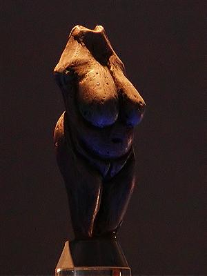
Piešťany (; , , , ) is a town in Slovakia. It is located in the western part of the country within the Trnava Region and is the seat of its Piešťany District, own district. It is the biggest and best known spa town in Slovakia and has around 28,000 inhabitants. Etymology The name Piešťany comes from Slovak language, Slovak ''Piesok'' (sand), referring to local sandbanks. The etymology is straightforward – ''Piešťanci'' – people who live on the sandy site and ''Piešťany'' – their settlement. History The first human settlement in the area is dated to the Prehistory, prehistoric times, about 80,000 years ago. People were attracted to the site by abundance of game in the vicinity of the thermal springs that did not freeze in winter. A small female statue representing female fertility called Venus of Moravany was found in the nearby village Moravany nad Váhom. It is made of mammoth ivory and is dated to 22,800 BC. It currently resides in the Bratislava Castle museu ... [...More Info...] [...Related Items...] OR: [Wikipedia] [Google] [Baidu] |
Považský Inovec
Považský Inovec is a mountain range in western Slovakia, named after the Váh river. It is long and wide mountain range. It is situated from the city of Hlohovec, raising from the Danubian Hills, and slowly raising further north until nearly to the city of Trenčín where it borders the Strážov Mountains, where is also the highest hill of the entire mountain range, ''Inovec'' (1042 m). The mountain range separates basins of the Váh and Nitra rivers. There are many monuments in or near the mountain range, including Great Moravian hill fort ''Kostolec'' near Ducové, Hlohovec Castle near Hlohovec, Beckov Castle near Beckov, Topoľčany Castle and Tematín Castle. The famous spa city of Piešťany lies under Považský Inovec. Geology Považský Inovec Mts. is considered as asymmetric horst emerging from the Neogene sedimentary fill of the Pannonian Basin between the Váh and Nitra rivers. The horst is bordered by steep normal faults and usually divided from north to ... [...More Info...] [...Related Items...] OR: [Wikipedia] [Google] [Baidu] |
Trnava Region
The Trnava Region (, ; ; ) is one of the eight Slovak administrative regions. It was established in 1996, before which date, most of its districts were parts of Bratislava Region which was established on the founding of Czechoslovakia in 1923. It consists of 251 municipalities, from which 16 have a town status. It is the second most densely populated region in Slovakia. Geography In the lower, west part of Slovakia, the Trnava region forms a territorial band between the Bratislava Region and the rest of Slovakia, between Austrian and Czech borders in the north and north-west and the Hungarian border in the south. The part north of the Little Carpathians is part of the Záhorie Lowland, with its two subdivisions: hilly Chvojnická pahorkatina and flat Borská nížina. In addition to these, the Myjava Hills and the White Carpathians reach into the area. The fertile Danubian Lowland is located south of the Little Carpathians, again with two subdivisions: the Danubian Flat ... [...More Info...] [...Related Items...] OR: [Wikipedia] [Google] [Baidu] |
Amber Road
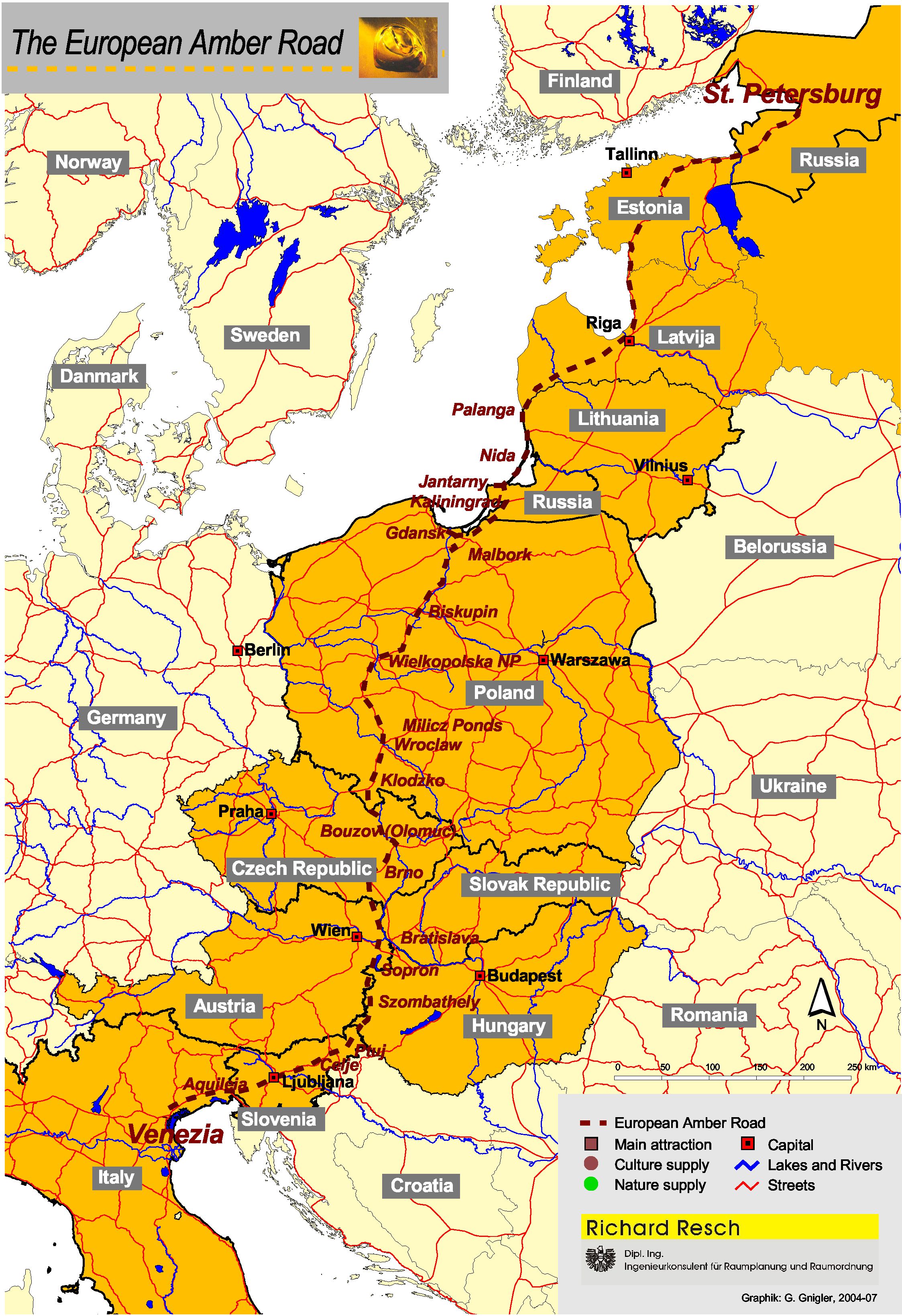
The Amber Road was an ancient trade route for the transfer of amber from coastal areas of the North Sea and the Baltic Sea to the Mediterranean Sea. Prehistoric trade routes between Northern and Southern Europe were defined by the amber trade. As an important commodity, sometimes dubbed "the gold of the north", amber was transported from the North Sea and Baltic Sea coasts overland by way of the Vistula and Dnieper rivers to Italy, Greece, the Black Sea, Syria and Egypt over a period of thousands of years. Antiquity The oldest trade in amber started from Sicily. The Sicilian amber trade was directed to Greece, North Africa and Spain. Sicilian amber was also discovered in Mycenae by the archaeologist Heinrich Schliemann, and it appeared in sites in southern Spain and Portugal. Its distribution is similar to that of ivory, so it is possible that amber from Sicily reached the Iberian Peninsula through contacts with North Africa. After a decline in the consumption and trade of amb ... [...More Info...] [...Related Items...] OR: [Wikipedia] [Google] [Baidu] |
Villages And Municipalities In Piešťany District
A village is a human settlement or community, larger than a hamlet but smaller than a town with a population typically ranging from a few hundred to a few thousand. Although villages are often located in rural areas, the term urban village is also applied to certain urban neighborhoods. Villages are normally permanent, with fixed dwellings; however, transient villages can occur. Further, the dwellings of a village are fairly close to one another, not scattered broadly over the landscape, as a dispersed settlement. In the past, villages were a usual form of community for societies that practice subsistence agriculture and also for some non-agricultural societies. In Great Britain, a hamlet earned the right to be called a village when it built a church.-4; we might wonder whether there's a point at which it's appropriate to talk of the beginnings of French, that is, when it wa ... ''village'', from Latin ''villāticus'', ultimately from Latin ''villa'' (English ''villa''). Ce ... [...More Info...] [...Related Items...] OR: [Wikipedia] [Google] [Baidu] |


