|
Dorchester Bay (Boston Harbor)
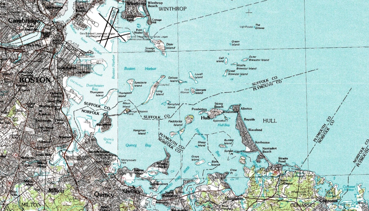
Dorchester Bay is the smallest of the three smaller bays of southern Boston Harbor, part of Massachusetts Bay and forming the south shoreline of the South Boston neighborhood and northeast shoreline of the Dorchester neighborhood of Boston, as well as the north shore of the city of Quincy in Massachusetts."Boston Harbor and Approaches." ''Coast Pilot 1 - 39th Edition, 2009'' NOAA Office of Coast Survey. 39th Edition. September, 2009. The bay is home to Thompson Island, one of the Boston Harbor Islands. The |
Massachusetts
Massachusetts ( ; ), officially the Commonwealth of Massachusetts, is a U.S. state, state in the New England region of the Northeastern United States. It borders the Atlantic Ocean and the Gulf of Maine to its east, Connecticut and Rhode Island to its south, New Hampshire and Vermont to its north, and New York (state), New York to its west. Massachusetts is the List of U.S. states and territories by area, sixth-smallest state by land area. With a 2024 U.S. Census Bureau-estimated population of 7,136,171, its highest estimated count ever, Massachusetts is the most populous state in New England, the List of U.S. states and territories by population, 16th-most-populous in the United States, and the List of states and territories of the United States by population density, third-most densely populated U.S. state, after New Jersey and Rhode Island. Massachusetts was a site of early British colonization of the Americas, English colonization. The Plymouth Colony was founded in 16 ... [...More Info...] [...Related Items...] OR: [Wikipedia] [Google] [Baidu] |
Squantum Point Park
Squantum Point Park is a state-owned, public recreation area located on the Squantum peninsula of Quincy, Massachusetts, United States. The park was created on the site of the former Squantum Naval Air Station, which is preserved in a strip of runway, and the former dockworks of the Bethlehem Shipbuilding Corporation. The park is managed by the Massachusetts Department of Conservation and Recreation and is associated with the development of the Neponset River Reservation. Activities and amenities The park provides views of the Boston skyline and opportunities for picnicking, canoeing, bird watching, and shoreline fishing as well as paths for running and in-line skating. It is the eastern terminus of the Quincy RiverWalk, a 2-mile trail along the Quincy side of the Neponset River The Neponset River is a river in eastern Massachusetts in the United States. Its headwaters are at the Neponset Reservoir in Foxborough, near Gillette Stadium. From there, the Neponset meanders ... [...More Info...] [...Related Items...] OR: [Wikipedia] [Google] [Baidu] |
South Boston
South Boston (colloquially known as Southie) is a densely populated neighborhood of Boston, Massachusetts, United States, located south and east of the Fort Point Channel and abutting Dorchester Bay (Boston Harbor), Dorchester Bay. It has undergone several demographic transformations since being annexed to the city of Boston in 1804. The neighborhood, once primarily farmland, is popularly known by its twentieth century identity as a working class Irish Catholics, Irish Catholic community. Throughout the twenty-first century, the neighborhood has become increasingly popular with Millennials, millennial professionals. South Boston contains Dorchester Heights, where George Washington forced British troops to evacuate during the American Revolutionary War. South Boston has undergone gentrification, and consequently, its real estate market has seen property values join the highest in the city. South Boston has also left its mark on history with Boston busing desegregation. South Bost ... [...More Info...] [...Related Items...] OR: [Wikipedia] [Google] [Baidu] |
Columbia Point, Boston
Columbia Point, in the Dorchester neighborhood of Boston, Massachusetts, sits on a peninsula jutting out from the mainland of eastern Dorchester into the bay. Old Harbor Park is on the north side, adjacent to Old Harbor, part of Dorchester Bay. The peninsula is primarily occupied by Harbor Point, the University of Massachusetts Boston, the John F. Kennedy Presidential Library and Museum, the Edward M. Kennedy Institute for the United States Senate, and a complex at the former Bayside Expo Center, Boston College High School, and the Massachusetts Archives. The Boston Harborwalk follows the entire coastline. History 17th–19th centuries In Dorchester, Columbia Point was the landing place for Puritan settlers in the early 1600s. The Native Americans called it "Mattaponnock"."Calf Pasture Pumping Station"< ... [...More Info...] [...Related Items...] OR: [Wikipedia] [Google] [Baidu] |
Metropolitan Park System Of Greater Boston
The Metropolitan Park System of Greater Boston is a system of reservations, parks, parkways and roads under the control of the Massachusetts Department of Conservation and Recreation (DCR) in and around Boston that has been in existence for over a century. The title is used by the DCR to describe the areas collectively: "As a whole, the Metropolitan Park System is currently eligible for listing on the National Register of Historic Places", as outlined on the department's website. The DCR maintains a separate Urban Parks and Recreation division to oversee the system, one of five such divisions within the department—DCR's Bureau of State Parks and Recreation manages the remainder of Massachusetts state parks. Direct design and maintenance functions for the parkways and roads within the system are provided by the DCR Bureau of Engineering. The park system consists of coastal reservations and beaches including Revere Beach, river reservations along the three major rivers in the a ... [...More Info...] [...Related Items...] OR: [Wikipedia] [Google] [Baidu] |
Massachusetts Department Of Conservation And Recreation
The Department of Conservation and Recreation (DCR) is a state agency of the Commonwealth of Massachusetts, United States, situated in the Executive Office of Energy and Environmental Affairs. It is best known for its parks and parkways. The DCR's mission is "To protect, promote and enhance our common wealth of natural, cultural and recreational resources for the well-being of all." The agency is the largest landowner in Massachusetts. History and structure The Department of Conservation and Recreation was formed in 2003 under Governor Mitt Romney, when the former Metropolitan District Commission (MDC) and Department of Environmental Management (DEM) were merged to form the DCR. The DCR is under the general management of the Commissioner of the DCR. The general administration divisions; Human Resources Division, the Financial Division, and External and Legislative Affairs, report directly to the Commissioner. DCR is responsible for the stewardship of its lands, from genera ... [...More Info...] [...Related Items...] OR: [Wikipedia] [Google] [Baidu] |
Day Boulevard
William J. Day Boulevard, or Day Boulevard, is a coastal parkway in Boston, Massachusetts. Beginning at Morrissey Boulevard and Kosciuszko Circle at the northern extent of the Dorchester section of the city, it travels in a gently curving northeasterly direction through South Boston along beaches around the west and north shore of Dorchester Bay. It was named for William J. Day. In its eastern part, the road passes through the South Boston Boat Clubs Historic District and Marine Park before ending at Castle Island, site of a historic fort and state park.Office of Geographic and Environmental Information (MassGIS), Commonwealth of Massachusetts Executive Office of Environmental Affairs - http://www.mass.gov/mgis/dd-over.htm It is owned and maintained by the Massachusetts Department of Conservation and Recreation as part of the Metropolitan Park System of Greater Boston. Carson Beach, M Street Beach and Pleasure Bay are beaches along Day Boulevard that are part of the park sy ... [...More Info...] [...Related Items...] OR: [Wikipedia] [Google] [Baidu] |
John F
John is a common English name and surname: * John (given name) * John (surname) John may also refer to: New Testament Works * Gospel of John, a title often shortened to John * First Epistle of John, often shortened to 1 John * Second Epistle of John, often shortened to 2 John * Third Epistle of John, often shortened to 3 John People * John the Baptist (died ), regarded as a prophet and the forerunner of Jesus Christ * John the Apostle (died ), one of the twelve apostles of Jesus Christ * John the Evangelist, assigned author of the Fourth Gospel, once identified with the Apostle * John of Patmos, also known as John the Divine or John the Revelator, the author of the Book of Revelation, once identified with the Apostle * John the Presbyter, a figure either identified with or distinguished from the Apostle, the Evangelist and John of Patmos Other people with the given name Religious figures * John, father of Andrew the Apostle and Saint Peter * Pope Jo ... [...More Info...] [...Related Items...] OR: [Wikipedia] [Google] [Baidu] |
Neponset River
The Neponset River is a river in eastern Massachusetts in the United States. Its headwaters are at the Neponset Reservoir in Foxborough, near Gillette Stadium. From there, the Neponset meanders generally northeast for about to its mouth at Dorchester Bay between Quincy and the Dorchester section of Boston, near the painted gas tank. The Neponset River forms the southern boundary of the city of Boston, passing through the neighborhoods of Readville, Hyde Park, Mattapan and Dorchester, and forms the northern border of the city of Quincy. In addition, the Neponset touches the towns of Foxborough, Walpole, Sharon, Norwood, Canton, Stoughton, Westwood, Dedham, and Milton. The Neponset River is fed by a drainage basin of approximately 130 square miles, a watershed that includes numerous aquifers, wetlands, streams, and surrounding upland areas. Some 250,000 people live in the Neponset River watershed, which in addition to the towns listed above, includes portions ... [...More Info...] [...Related Items...] OR: [Wikipedia] [Google] [Baidu] |
Boston Harbor
Boston Harbor is a natural harbor and estuary of Massachusetts Bay, located adjacent to Boston, Massachusetts. It is home to the Port of Boston, a major shipping facility in the Northeastern United States. History 17th century Since its discovery by Europeans by John Smith in 1614, Boston Harbor has been an important port in American history. Boston Harbor was recognized by Europeans as one of the finest natural harbors in the world due to its depth and natural defense from the Atlantic as a result of the many islands that dot the harbor. It was also favored due to its access to the Charles River, Neponset River, and Mystic River, which made travel from the harbor deeper into Massachusetts far easier. By 1660, almost all imports came to the greater Boston area and the New England coast through the waters of Boston Harbor. A rapid influx of people transformed Boston into an exploding city. 18th century On December 16, 1773, Boston Harbor was the site of the Boston Tea ... [...More Info...] [...Related Items...] OR: [Wikipedia] [Google] [Baidu] |
Boston Harbor Islands
Boston Harbor Islands National and State Park is a combination national recreation area and state park situated among the islands of Boston Harbor. The park is made up of 34 islands and peninsulas and is managed by the Boston Harbor Islands Partnership. Twenty-one of the islands are also included in the Boston Harbor Islands Archeological District. The park is significant for a wide range of natural and cultural resources, including three national historic landmarks, unique geological features, archaeological resources resulting from thousands of years of occupation of the islands by indigenous people of Massachusetts, and complex natural communities. Attractions include hiking trails, beaches, the Civil War-era Fort Warren, and Boston Light, the oldest lighthouse station in the United States. Georges Island and Spectacle Island are served seasonally by ferries to and from Boston, and Peddocks Island is served by a ferry from Hingham. List of islands and peninsulas The ... [...More Info...] [...Related Items...] OR: [Wikipedia] [Google] [Baidu] |
Thompson Island (Massachusetts)
Cathleen Stone Island, also known as Thompson Island, is a island in the Dorchester Bay (Boston Harbor), Dorchester Bay section of Boston Harbor, offshore from Downtown Boston, downtown Boston, Massachusetts. It is located slightly more than from Boston's Long Wharf (Boston), Long Wharf via boat, while approximately straight-line distance from Boston's Columbia Point, Boston, Columbia Point. The island is managed by the Cathleen Stone Island Outward Bound Education Center, a non-profit education organization. The island is open to visitors on Saturdays and Sundays from Memorial Day through Labor Day; otherwise access is by arrangement only. Cathleen Stone Island is one of the largest, most accessible and ecologically diverse islands in the Boston Harbor Islands National Recreation Area. The island's highest point is a drumlin that reaches a height of above sea level. The rest of the island comprises low rolling hills and a salt marsh. The island has a mixed vegetation, includ ... [...More Info...] [...Related Items...] OR: [Wikipedia] [Google] [Baidu] |


