|
District Of Duchy Of Lauenburg
Duchy of Lauenburg ( ) is the southernmost ''Kreis'', or district, officially called District of Duchy of Lauenburg (), of Schleswig-Holstein, Germany. It is bordered by (from the west and clockwise) the district of Stormarn, the city of Lübeck, the state of Mecklenburg-Vorpommern (districts of Nordwestmecklenburg and Ludwigslust-Parchim), the state of Lower Saxony (districts of Lüneburg and Harburg), and the city state of Hamburg. The district of Herzogtum Lauenburg is named after the former Duchy of Saxe-Lauenburg. Geography The district's territory comprises most of the former Duchy's territory north of the river Elbe, except of the Amt Neuhaus. All the former Saxe-Lauenburgian areas beyond the Elbe belong today to the Lower Saxon districts of Cuxhaven (Land of Hadeln), Harburg and Lüneburg. The district's area contains a number of historically important towns, e.g. Lauenburg/Elbe, Mölln and Ratzeburg. This importance was due to the Old Salt Route (''Alte Salzstra ... [...More Info...] [...Related Items...] OR: [Wikipedia] [Google] [Baidu] |
Ratzeburg
Ratzeburg (; Low German: ''Ratzborg'') is a town in Schleswig-Holstein, Germany. It is surrounded by Ratzeburger See, four lakes—the resulting isthmuses between the lakes form the access lanes to the town. Ratzeburg is the capital of the district Herzogtum Lauenburg. History The town was founded in the 11th century as Racisburg. The name is traditionally derived from the local Wends, Wendish ruler, Prince Ratibor (Polabian prince), Ratibor of the Polabians (tribe), Polabians, who was nicknamed Ratse. In the year 1044 Christian missionaries under the leadership of the monk Ansverus came into the region and built a monastery. It was destroyed in a Slavic rebellion of 1066, pagan rebellion in 1066; the monks were stoned to death. Today monuments to the missionaries in two of the town's churches commemorate these events. Ansverus was canonised in the 12th century and his relics were entombed in the Ratzeburg cathedral. Henry the Lion became the ruler of the town in 1143 and estab ... [...More Info...] [...Related Items...] OR: [Wikipedia] [Google] [Baidu] |
Land Of Hadeln
Land Hadeln is a historic landscape and former administrative district in Northern Germany with its seat in Otterndorf on the Niederelbe, Lower Elbe, the lower reaches of the River Elbe, in the Elbe-Weser Triangle between the estuaries of the Elbe and Weser. The name goes back to a place named ''Haduloha'' in the Royal Frankish Annals, which must have been in the north of Hohe Lieth moraine range, west of present-day Cuxhaven. Enthusiastic historians of late 19th and early 20th century postulated an Old Saxon ''Gau (country subdivision), Gau'' (district) of that name, but there is no evidence for this theory.Hans-Ulrich Hucker: Das Problem von Herrschaft und Freiheit in den Landesgemeinden des Mittelalters im Unterweserraum (Thesis, Münster 1978), available in Staatsarchiv Bremen (n°. 538 U) und in the Library of ''Männer vom Morgenstern'' historical society in Bremerhaven In the Middle Ages, the Land Hadeln was a fairly, but not perfectly, autonomous rural community, apply ... [...More Info...] [...Related Items...] OR: [Wikipedia] [Google] [Baidu] |
Wittenberg
Wittenberg, officially Lutherstadt Wittenberg, is the fourth-largest town in the state of Saxony-Anhalt, in the Germany, Federal Republic of Germany. It is situated on the River Elbe, north of Leipzig and south-west of the reunified German federal capital city of Berlin, and has a population of 46,008 (2018). Wittenberg has close connections with Martin Luther (1483–1546) and the 16th century religious / theological movement of Protestantism begun here in the Reformation, and the large branch of Western Christianity started here of Lutheranism, Evangelical Lutheranism, for which it received the honorific title ''Lutherstadt'' and has been called the "cradle of the Reformation" and "cradle of Protestantism". Several of Wittenberg's buildings are associated with the historical / religious events, including a preserved part of the Augustinians, Augustinian monastery of the local community of the world-wide Catholic Church, Roman Catholic Order of St. Augustine in which Luth ... [...More Info...] [...Related Items...] OR: [Wikipedia] [Google] [Baidu] |
Encyclopædia Britannica
The is a general knowledge, general-knowledge English-language encyclopaedia. It has been published by Encyclopædia Britannica, Inc. since 1768, although the company has changed ownership seven times. The 2010 version of the 15th edition, which spans 32 volumes and 32,640 pages, was the last printed edition. Since 2016, it has been published exclusively as an online encyclopedia, online encyclopaedia. Printed for 244 years, the ''Britannica'' was the longest-running in-print encyclopaedia in the English language. It was first published between 1768 and 1771 in Edinburgh, Scotland, in three volumes. The encyclopaedia grew in size; the second edition was 10 volumes, and by its fourth edition (1801–1810), it had expanded to 20 volumes. Its rising stature as a scholarly work helped recruit eminent contributors, and the 9th (1875–1889) and Encyclopædia Britannica Eleventh Edition, 11th editions (1911) are landmark encyclopaedias for scholarship and literary ... [...More Info...] [...Related Items...] OR: [Wikipedia] [Google] [Baidu] |
Albert I, Duke Of Saxony
Albert I (; 1175 – 7 October 1260) was a Duke of Saxony, Angria, and Westphalia; Lord of Nordalbingia; Count of Anhalt; and Prince-elector and Archmarshal of the Holy Roman Empire. Even though his grandfather Albert the Bear had held the Saxon dukedom between 1138 and 1142, this Albert is counted as the first. Biography A member of the House of Ascania, Albert was a younger son of Bernard III, Duke of Saxony, and Judith (Jutta) of Poland, daughter of Mieszko III the Old. After his father's death in 1212, the surviving sons of the late duke divided his lands according to the laws of the House of Ascania: The elder Henry received Anhalt and the younger Albert the Saxon duchy. Albert supported Otto IV, Holy Roman Emperor Otto IV (1175 – 19 May 1218) was the Holy Roman Emperor from 1209 until his death in 1218. Otto spent most of his early life in England and France. He was a follower of his uncle Richard the Lionheart, who made him Count of Poitou in 1196 ..., in his ... [...More Info...] [...Related Items...] OR: [Wikipedia] [Google] [Baidu] |
John I, Duke Of Saxony
John I (1249 – 30 July 1285) ruled as duke of Saxony from 1260 until 1282. John was the elder son of Duke Albert I of Saxony and his third wife Helen, a daughter of Otto the Child. John and his younger brother Albert II jointly ruled the Duchy of Saxony after the death of their father Albert I in 1260. In 1269, 1272, and 1282 the brothers gradually divided their land within the three territorially unconnected Saxon areas (one called Land of Hadeln around Otterndorf, another around Lauenburg upon Elbe and the third around Wittenberg), thus preparing a partition. As part of this arrangement John I became Burgrave of Magdeburg in 1269. In the imperial election in 1273, Albert II represented the jointly ruling brothers. In 1270, John married Ingeborg (c. 1253–30 June 1302), possibly a daughter of Birger Jarl or King Erik Eriksson of Sweden.Gillingstam, Hans"Recensioner: Gorm den gamles ättlingar."''Personhistorisk tidskrift'' 65 (1967): 3. They had eight children, amon ... [...More Info...] [...Related Items...] OR: [Wikipedia] [Google] [Baidu] |
Albert II, Duke Of Saxony
Albert II of Saxony (Wittenberg, Wittenberg upon Elbe, ca. 1250 – 25 August 1298, near Aken (Elbe), Aken) was a son of Duke Albert I, Duke of Saxony, Albert I of Saxony and his third wife Helen of Brunswick and Lunenburg, a daughter of Otto the Child. He supported Rudolph I of Germany at his election as King of the Romans, Roman king and became his son-in-law. After the death of their father Albert I in 1260 Albert II jointly ruled the Duchy of Saxony with his elder brother John I, Duke of Saxony, John I, and thereafter with the latter's sons. Life In 1269, 1272 and 1282 the brothers gradually divided their governing competences within the three territorially unconnected Saxon areas (one called Land of Hadeln around Otterndorf, another around Lauenburg/Elbe, Lauenburg upon Elbe and the third around Wittenberg), thus preparing a partition. In the Imperial election of 1273, imperial election in 1273 Albert II represented the jointly ruling brothers. In return Rudolph I had marri ... [...More Info...] [...Related Items...] OR: [Wikipedia] [Google] [Baidu] |
Duchy Of Saxony
The Duchy of Saxony () was originally the area settled by the Saxons in the late Early Middle Ages, when they were subdued by Charlemagne during the Saxon Wars from 772 CE and incorporated into the Carolingian Empire (Francia) by 804. Upon the 843 Treaty of Verdun, Saxony was one of the five German stem duchies of East Francia; Duke Henry the Fowler was elected List of German monarchs, German king in 919. Upon the deposition of the House of Welf, Welf duke Henry the Lion in 1180, the ducal title fell to the House of Ascania, while numerous territories split from Saxony, such as the Principality of Anhalt in 1218 and the Welf Duchy of Brunswick-Lüneburg in 1235. In 1296, the remaining lands were divided between the Ascanian dukes of Saxe-Lauenburg and Duchy of Saxe-Wittenberg, Saxe-Wittenberg, the latter obtaining the title of Electorate of Saxony, Electors of Saxony by the Golden Bull of 1356. Geography The Saxon stem duchy covered the greater part of present-day Northern Germ ... [...More Info...] [...Related Items...] OR: [Wikipedia] [Google] [Baidu] |
Ratzeburger See
is a lake in Schleswig-Holstein, Germany. At an elevation of 4 m, its surface area is 14.3 km2. Amidst the lake is an island upon which the City of Ratzeburg is located, accessible from the mainland via three isthmuses. The island is home to the Old Town, including a cathedral - one of the oldest in Germany. At the end of the 17th century, the old castle at the western end of the island was completely destroyed and the site has since been degraded to a mere parking lot. During the division of Germany, the northeastern coast of the lake (between the Römnitz hamlet of Hohenleuchte and Groß Sarau hamlet of Rothenhusen) was part of the Inner German border The inner German border ( or ''deutsch–deutsche Grenze''; initially also , zonal boundary) was the frontier between the East Germany, German Democratic Republic (GDR, East Germany) and the West Germany, Federal Republic of Germany (FRG, West .... It served as a border sluice for Stasi agents to infiltrate West Germ ... [...More Info...] [...Related Items...] OR: [Wikipedia] [Google] [Baidu] |
Lauenburg Lakes Nature Park
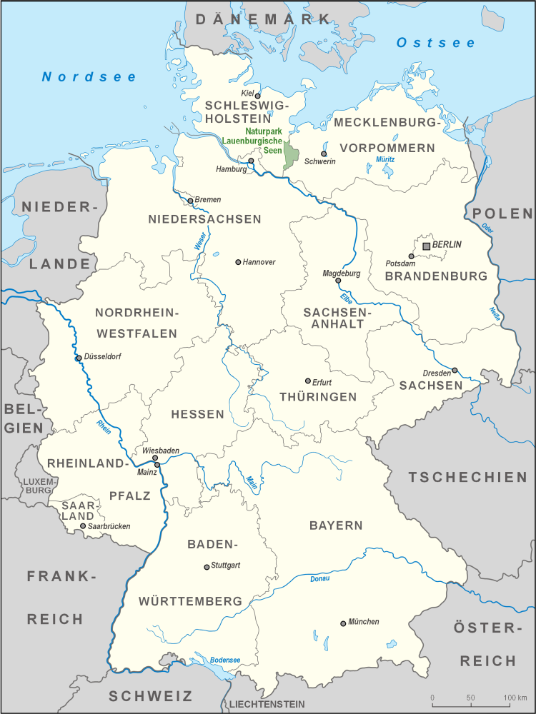
The Lauenburg Lakes Nature Park () at www.germany.travel. Retrieved 20 Apr 2020. was founded in and lies in the district of Lauenburg in the southeastern part of the German state of . It is right on the border with the state of Mecklenburg-Vorpommern in the Schleswig-Holstein Uplands, a Young Drift moraine landscape that formed durin ... [...More Info...] [...Related Items...] OR: [Wikipedia] [Google] [Baidu] |
Stecknitz Canal
The Stecknitz Canal () was an artificial waterway in northern Germany which connected Lauenburg and Lübeck on the Old Salt Route by linking the tiny rivers Stecknitz (a tributary of the Trave) and Delvenau (a tributary of the Elbe), thus establishing an inland water route across the drainage divide from the North Sea to the Baltic Sea. Built between 1391 and 1398, the Stecknitz Canal was the first European summit-level canal and one of the earliest artificial waterways in Europe. In the 1890s the canal was replaced by an enlarged and straightened waterway called the Elbe–Lübeck Canal, which includes some of the Stecknitz Canal's watercourse. The original artificial canal was deep and wide; the man-made segment ran for , with a total length of including the rivers it linked. The canal included seventeen wooden locks (of which the ''Palmschleuse'' at Lauenburg still exists) that managed the elevation difference between its endpoints and the highest central part, the ... [...More Info...] [...Related Items...] OR: [Wikipedia] [Google] [Baidu] |


