|
Diamond Keelboat
The Yachting World Diamond Keelboat (abbreviation: YW Diamond) is a multiple-chine sailing yacht nominally 30 feet in overall length, designed for racing and short-range inshore cruising. Origins In 1958 the editors of the British ''Yachting World'' magazine proposed a high-performance sailing yacht that could be built cheaply from modern materials then entering common usage such as marine plywood for the hull skin and light alloy for the spars. Definitive plans were drawn up by well-known sailing dinghy designer Jack Holt and a prototype named ''Zest'' was completed in time for the 1961 International Boat Show in London. Plans were sold under the name Yachting World Keelboat in the hope that it would be adopted as a National and International racing class. ''Zest'' carried on her sail the identification number 1 below a black diamond, and after many years being nicknamed the Diamond Class, the name Yachting World Diamond or YW Diamond was officially adopted for the class in 19 ... [...More Info...] [...Related Items...] OR: [Wikipedia] [Google] [Baidu] |
Chine (boating)
A chine in boat design is a sharp change in angle in the cross section of a hull. The chine typically arises from the use of sheet materials (such as sheet metal or marine ply) as the mode of construction. Rationale of chines Using sheet materials in boat construction is cheap and simple, but whereas these sheet materials are flexible longitudinally, they tend to be rigid vertically. Examples of steel vessels with hard chines include narrowboats and widebeams; examples of plywood vessels with hard chines include sailing dinghies such as the single-chined Graduate (dinghy), Graduate and the double-chined Enterprise (dinghy), Enterprise. Although a hull made from sheet materials might be unattractively "slab-sided", most chined hulls are designed to be pleasing to the eye and hydrodynamics, hydrodynamically efficient. Hulls without chines (such as clinker-built or carvel-built vessels) usually have a gradually curving cross section. A hard chine is an angle with little rou ... [...More Info...] [...Related Items...] OR: [Wikipedia] [Google] [Baidu] |
Metres
The metre ( British spelling) or meter ( American spelling; see spelling differences) (from the French unit , from the Greek noun , "measure"), symbol m, is the primary unit of length in the International System of Units (SI), though its prefixed forms are also used relatively frequently. The metre was originally defined in 1793 as one ten-millionth of the distance from the equator to the North Pole along a great circle, so the Earth's circumference is approximately km. In 1799, the metre was redefined in terms of a prototype metre bar (the actual bar used was changed in 1889). In 1960, the metre was redefined in terms of a certain number of wavelengths of a certain emission line of krypton-86. The current definition was adopted in 1983 and modified slightly in 2002 to clarify that the metre is a measure of proper length. From 1983 until 2019, the metre was formally defined as the length of the path travelled by light in a vacuum in of a second. After the 2019 re ... [...More Info...] [...Related Items...] OR: [Wikipedia] [Google] [Baidu] |
Victoria (Australia)
Victoria is a state in southeastern Australia. It is the second-smallest state with a land area of , the second most populated state (after New South Wales) with a population of over 6.5 million, and the most densely populated state in Australia (28 per km2). Victoria is bordered by New South Wales to the north and South Australia to the west, and is bounded by the Bass Strait to the south (with the exception of a small land border with Tasmania located along Boundary Islet), the Great Australian Bight portion of the Southern Ocean to the southwest, and the Tasman Sea (a marginal sea of the South Pacific Ocean) to the southeast. The state encompasses a range of climates and geographical features from its temperate coastal and central regions to the Victorian Alps in the northeast and the semi-arid north-west. The majority of the Victorian population is concentrated in the central-south area surrounding Port Phillip Bay, and in particular within the metr ... [...More Info...] [...Related Items...] OR: [Wikipedia] [Google] [Baidu] |
Geelong
Geelong ( ) ( Wathawurrung: ''Djilang''/''Djalang'') is a port city in the south eastern Australian state of Victoria, located at the eastern end of Corio Bay (the smaller western portion of Port Phillip Bay) and the left bank of Barwon River, about southwest of Melbourne, the state capital of Victoria. Geelong is the second largest Victorian city (behind Melbourne) with an estimated urban population of 268,277 as of June 2018, Estimated resident population, 30 June 2018. and is also Australia's second fastest-growing city. Geelong is also known as the "Gateway City" due to its critical location to surrounding western Victorian regional centres like Ballarat in the northwest, Torquay, Great Ocean Road and Warrnambool in the southwest, Hamilton, Colac and Winchelsea to the west, providing a transport corridor past the Central Highlands for these regions to the state capital Melbourne in its northeast. The City of Greater Geelong is also a member of thGateway Ci ... [...More Info...] [...Related Items...] OR: [Wikipedia] [Google] [Baidu] |
Royal Geelong Yacht Club
The Royal Geelong Yacht Club is a yacht club founded in 1859 and based in Geelong, Victoria, Australia. The club received its royal patronage in 1924. The club is based on the shores of Corio Bay in central Geelong. The 223-berth Bay City Marina was built in the 1980s in front of the clubhouse, and forms part of the Waterfront Geelong The Geelong Waterfront is a tourist and recreation area on the north facing shores of Corio Bay in Geelong, Australia. The area was once part of the Port of Geelong, falling into disuse before being redeveloped during the 1990s. Attractions ... precinct. The Yacht Club is famous for hosting the Festival of Sails, the highly popular keelboat regatta in Australia, which attracts the best sailing crew. It was hosted for the first time by the Yacht Club in 1925 and by 1986 witnessed participation of 361 yachts. References {{reflist External linksOfficial Site Royal yacht clubs Sport in Geelong Sports teams in Victoria (Australia) Yacht ... [...More Info...] [...Related Items...] OR: [Wikipedia] [Google] [Baidu] |
Williamstown, Victoria
Williamstown is a suburb in Melbourne, Victoria (Australia), Victoria, Australia, south-west of Melbourne's Melbourne city centre, Central Business District, located within the City of Hobsons Bay Local government areas of Victoria, local government area. Williamstown recorded a population of 14,407 at the 2021 Australian census, 2021 census. History Indigenous history Indigenous Australians occupied the area long before maritime activities shaped the modern historical development of Williamstown. The Yalukit-willam clan of the Kulin nation were the first people to call Hobsons Bay home. They roamed the thin coastal strip from Werribee to Williamstown/Hobsons Bay. The Yalukit-willam were one clan in a language group known as the Bunurong, which included six clans along the coast from the Werribee River, across the Mornington Peninsula, Western Port Bay to Wilsons Promontory. The Yalukit-willam referred to the Williamstown area as "koort-boork-boork", a term meaning "clump of ... [...More Info...] [...Related Items...] OR: [Wikipedia] [Google] [Baidu] |
Royal Yacht Club Of Victoria
The Royal Yacht Club of Victoria (RYCV) is one of Australia's oldest yacht clubs. It is based in the Melbourne suburb of Williamstown, not far from where the Yarra River flows into Port Phillip Bay. History The club was founded in May 1853 as the Port Phillip Yacht Club, and is the oldest yacht club in Australia. By 1856, it had been renamed Victoria Yacht Club, and in that year it held its first regatta. Early members included W.R. Probert and George F. Verdon, who ran a ship chandlery and commission agents business in Sandridge (now Port Melbourne), Dr. John Wilkins, the Surgeon for the Port of Melbourne, and Captain Charles Ferguson, the Harbour Master at Williamstown. Initially, the club's races were held mainly on Corio Bay, where many of the club's fleet was moored between 1856 and 1864, and at St Kilda. As the club lacked the funds to purchase its own clubhouse, meetings during the club's early years were held in at least six places around Melbourne and its suburbs. ... [...More Info...] [...Related Items...] OR: [Wikipedia] [Google] [Baidu] |
Tasmania
) , nickname = , image_map = Tasmania in Australia.svg , map_caption = Location of Tasmania in AustraliaCoordinates: , subdivision_type = Country , subdivision_name = Australia , established_title = Before federation , established_date = Colony of Tasmania , established_title2 = Federation , established_date2 = 1 January 1901 , named_for = Abel Tasman , demonym = , capital = Hobart , largest_city = capital , coordinates = , admin_center = 29 local government areas , admin_center_type = Administration , leader_title1 = Monarch , leader_name1 = Charles III , leader_title2 = Governor , leader_n ... [...More Info...] [...Related Items...] OR: [Wikipedia] [Google] [Baidu] |
South Australia
South Australia (commonly abbreviated as SA) is a state in the southern central part of Australia. It covers some of the most arid parts of the country. With a total land area of , it is the fourth-largest of Australia's states and territories by area, and second smallest state by population. It has a total of 1.8 million people. Its population is the second most highly centralised in Australia, after Western Australia, with more than 77 percent of South Australians living in the capital Adelaide, or its environs. Other population centres in the state are relatively small; Mount Gambier, the second-largest centre, has a population of 33,233. South Australia shares borders with all of the other mainland states, as well as the Northern Territory; it is bordered to the west by Western Australia, to the north by the Northern Territory, to the north-east by Queensland, to the east by New South Wales, to the south-east by Victoria, and to the south by the Great Australian B ... [...More Info...] [...Related Items...] OR: [Wikipedia] [Google] [Baidu] |
New South Wales
) , nickname = , image_map = New South Wales in Australia.svg , map_caption = Location of New South Wales in AustraliaCoordinates: , subdivision_type = Country , subdivision_name = Australia , established_title = Before federation , established_date = Colony of New South Wales , established_title2 = Establishment , established_date2 = 26 January 1788 , established_title3 = Responsible government , established_date3 = 6 June 1856 , established_title4 = Federation , established_date4 = 1 January 1901 , named_for = Wales , demonym = , capital = Sydney , largest_city = capital , coordinates = , admin_center = 128 local government areas , admin_center_type = Administration , leader_title1 = Monarch , leader_name1 = Charles III , leader_title2 = Governor , leader_name2 = Margaret Beazley , leader_title3 = Premier , leader_name3 = Dominic Perrottet ( Liberal) , national_representation = Parliament of Australia , national_representation_type1 = Sen ... [...More Info...] [...Related Items...] OR: [Wikipedia] [Google] [Baidu] |
Pittwater
Pittwater is a semi-mature tide dominated drowned valley estuary, located about north of the Sydney central business district, New South Wales, Australia; being one of the bodies of water that separate greater Metropolitan Sydney from the Central Coast. Pittwater has its origin from the confluence of McCarrs Creek, to the west of Church Point and a number of smaller estuaries, the largest of which is Cahill Creek, that joins the Pittwater north of Mona Vale. The Pittwater is an open body of water, often considered a bay or harbour, that flows north towards its mouth into Broken Bay, between West Head and Barrenjoey Head, less than from the Tasman Sea. The total area of the Pittwater is and around ninety percent of the area is generally administered by the Hawkesbury–Nepean Catchment Management Authority, in conjunction with Northern Beaches Council. The land adjacent to the Pittwater was occupied for many thousands of years by the Kuringgai peoples, an Aborigi ... [...More Info...] [...Related Items...] OR: [Wikipedia] [Google] [Baidu] |
Camber (ship)
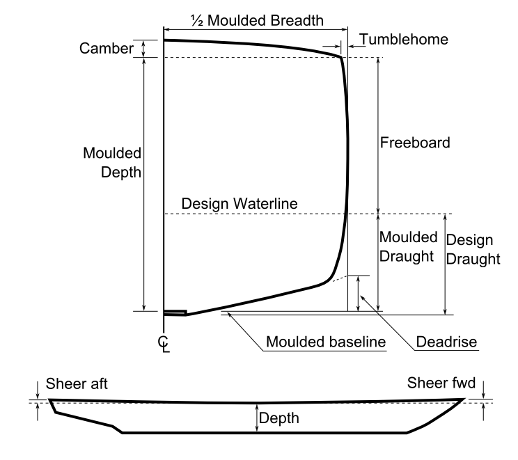
The camber is a measure of lateral main deck curvature in naval architecture. The curve is applied to a deck transversely, measured as the height of deck at centreline above the height of deck at side. The practice of adding camber to a ship's deck originated in the era of small sailing ship A sailing ship is a sea-going vessel that uses sails mounted on masts to harness the power of wind and propel the vessel. There is a variety of sail plans that propel sailing ships, employing square-rigged or fore-and-aft sails. Some ships ...s. These vessels were built with the decks curving downwards at the sides in order to allow water that washed onto the deck to spill off. Camber also adds to a ship's longitudinal strength. See also * Sheer (ship) References Naval architecture {{navy-stub ... [...More Info...] [...Related Items...] OR: [Wikipedia] [Google] [Baidu] |


