|
Dharoor Valley
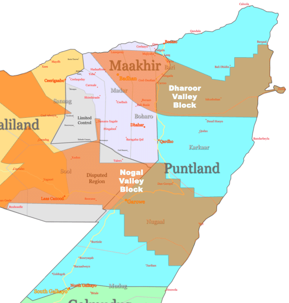
The Dharoor Valley ( so, Dooxada Dharoor) is valley located in the Bari province of the autonomous Puntland region in northeastern Somalia. It possesses relatively abundant grazing terrain for pastoralism, similar to the Noobir. Along with the Nugaal Valley, the Dharoor Valley has been a center for oil exploration in Puntland. References {{reflist See also *Nugaal Valley The Nugaal Valley ( so, Dooxada Nugaal, ar, وادي نوجال), also called the Nogal Valley, is a long and broad valley located in northern Somalia and Somaliland. The Nugaal Valley is bounded to the north by the ''Sorl'', or ''Nugal Plateau ... Valleys of Somalia ... [...More Info...] [...Related Items...] OR: [Wikipedia] [Google] [Baidu] |
Valley
A valley is an elongated low area often running between hills or mountains, which will typically contain a river or stream running from one end to the other. Most valleys are formed by erosion of the land surface by rivers or streams over a very long period. Some valleys are formed through erosion by glacial ice. These glaciers may remain present in valleys in high mountains or polar areas. At lower latitudes and altitudes, these glacially formed valleys may have been created or enlarged during ice ages but now are ice-free and occupied by streams or rivers. In desert areas, valleys may be entirely dry or carry a watercourse only rarely. In areas of limestone bedrock, dry valleys may also result from drainage now taking place underground rather than at the surface. Rift valleys arise principally from earth movements, rather than erosion. Many different types of valleys are described by geographers, using terms that may be global in use or else applied only locally. For ... [...More Info...] [...Related Items...] OR: [Wikipedia] [Google] [Baidu] |
Bari, Somalia
Bari ( so, Bari, ar, باري) is an administrative region ('' gobol'') in northeastern Somalia.⁹ Overview It is bordered by Sool and Sanaag to the west, Nugal to the south, the Gulf of Aden to the north and the Guardafui Channel to the east. It is located the tip of the Horn of Africa. Its name, Bari, literally means ''East'' in Somali. In terms of landmass, Bari is the largest province in the Federal Republic of Somalia. The highest point in this region is Mount Bahaya, the third tallest mountain in Somalia with an elevation of 2120 meters; other notable peaks include Karkaar and Cal Miskaad mountains. Demographics Most of the inhabitants of the Bari region belong to the Somali ethnic group; in particular the Deshiishe, majority of Majeerteen clans and also some of Leelkase sub-clans of the Darood, and the minority Madhiban According to the 2015 Population Estimation Survey, the population was 1,887,568 inhabitants. This figure combines both the rural and urban p ... [...More Info...] [...Related Items...] OR: [Wikipedia] [Google] [Baidu] |
Puntland
Puntland ( so, Puntland, ar, أرض البنط, it, Terra di Punt or ''Paese di Punt''), officially the Puntland State of Somalia ( so, Dowlad Goboleedka Puntland ee Soomaaliya, ar, ولاية أرض البنط الصومالية), is a Federal Member State in northeastern Somalia. The capital city is the city of Garoowe in the Nugal region, and its leaders declared the territory an autonomous state in 1998. Geographically to the west, Puntland lays claim to the intra-46th meridian territories that were outside European colonial rule during parts of the Scramble for Africa period. Puntland is bordered by Somaliland to its west, the Gulf of Aden in the north, the Guardafui Channel in the northeast, the Indian Ocean in the southeast, the central Galmudug region in the south, and Ethiopia in the southwest. There are several major geographical apexes in Puntland, including the Cape Guardafui, which forms the tip of the Horn of Africa, Ras Hafun the easternmost place ... [...More Info...] [...Related Items...] OR: [Wikipedia] [Google] [Baidu] |
Somalia
Somalia, , Osmanya script: 𐒈𐒝𐒑𐒛𐒐𐒘𐒕𐒖; ar, الصومال, aṣ-Ṣūmāl officially the Federal Republic of SomaliaThe ''Federal Republic of Somalia'' is the country's name per Article 1 of thProvisional Constitution, (; ), is a country in the Horn of Africa. The country is bordered by Ethiopia to the west, Djibouti to the northwest, the Gulf of Aden to the north, the Indian Ocean to the east, and Kenya to the southwest. Somalia has the longest coastline on Africa's mainland. Its terrain consists mainly of plateaus, plains, and highlands. Hot conditions prevail year-round, with periodic monsoon winds and irregular rainfall. Somalia has an estimated population of around million, of which over 2 million live in the Capital city, capital and largest city Mogadishu, and has been described as Africa's most culturally homogeneous country. Around 85% of its residents are ethnic Somalis, who have historically inhabited the country's north. Ethnic minoritie ... [...More Info...] [...Related Items...] OR: [Wikipedia] [Google] [Baidu] |
Nugaal Valley
The Nugaal Valley ( so, Dooxada Nugaal, ar, وادي نوجال), also called the Nogal Valley, is a long and broad valley located in northern Somalia and Somaliland. The Nugaal Valley is bounded to the north by the ''Sorl'', or ''Nugal Plateau'', and to the south by 'Iid. Overview The Nugaal Valley is a key pastoral area which spans across four regions, Nugal in Somalia and Sool, Sanaag and Togdheer in Somalia. Pastoral nomadism is the primary way of life for most of the people living in the valley. Goat and camel raising form the basis of the economy, and frankincense and myrrh are collected from wild trees. The beds of the watercourses have a few permanent wells, to which the predominantly nomadic population returns during the dry season. Low and erratic rainfall (about 5 inches 125 mm annually) and the high salinity of the soil limit crop cultivation. The segments of the Nugaal valley from Garowe eastwards is traditionally referred to as ''Bari Nugaaleed'' or ''Ba ... [...More Info...] [...Related Items...] OR: [Wikipedia] [Google] [Baidu] |
Oil Exploration In Puntland
Oil exploration in Puntland, an autonomous region in northeastern Somalia which is a federal state, began in the mid-2000s as a series of negotiations between the provincial administration and foreign oil companies. By 2012, exploratory wells established in the area yielded the first signs of crude oil. Overview Somalia has untapped reserves of numerous natural resources, including uranium, iron ore, tin, gypsum, bauxite, copper, salt and natural gas. The Puntland region in northeastern Somalia, in particular, came to be regarded as the geological analogue of Yemen since both areas once formed a single landmass around 18 million years ago, before the Gulf of Aden rifted and separated the Horn of Africa from the Arabian Peninsula. The oil reserves discovered in Yemen's Cretaceous and Jurassic formations were therefore also thought to potentially exist in Puntland, with petroleum geologists associating the Nugaal and Dharoor blocks with the South Yemen Marib-Shabwa and ... [...More Info...] [...Related Items...] OR: [Wikipedia] [Google] [Baidu] |


