|
Dhamoirhat Upazila
Dhamoirhat Upazila () is an upazila of Naogaon District Naogaon District () is a district in northern Bangladesh, and part of Rajshahi Division. It is named after its headquarters, the city of Naogaon in Naogaon Sadar Upazila. Demographics According to the 2022 Census of Bangladesh, Naogaon Distri ... in the Division of Rajshahi Division, Rajshahi, Bangladesh. The main river of the Dhamoirhat Upazila is the Atrai River, Atrai. History During the War of Liberation, the Pakistan army had camped at places like Farsipara, Pagla Dewan, Rangamati, etc. A direct encounter between the Pak army and the freedom fighters were held at Piral Danga, Gangra, Kulfatpur and Rangamati with the heavy casualty on both sides. The Pakistan army burnt and sacked the village Kulfatpur and killed 14 innocent villagers. Marks of War of Liberation Mass grave: 2 (Farsipara, Pagla Dewan). Geography Dhamoirhat is located at . It has 29661 households and total area 300.79 km2. Dhamoirhat Upazila is ... [...More Info...] [...Related Items...] OR: [Wikipedia] [Google] [Baidu] |
Balurghat (community Development Block)
Balurghat is a community development block that forms an administrative division in Balurghat subdivision of Dakshin Dinajpur district in the Indian state of West Bengal. History Dinajpur district was constituted in 1786. In 1947, the Radcliffe Line placed the Sadar and Thakurgaon subdivisions of Dinajpur district in East Pakistan. The Balurghat subdivision of Dinajpur district was reconstituted as West Dinajpur district in West Bengal. The new Raiganj subdivision was formed in 1948. In order to restore territorial links between northern and southern parts of West Bengal which had been snapped during the partition of Bengal, and on the recommendations of the States Reorganisation Commission a portion of the erstwhile Kishanganj subdivision comprising Goalpokhar, Islampur and Chopra thanas (police stations) and parts of Thakurganj thana, along with the adjacent parts of the erstwhile Gopalpur thana in Katihar subdivision were transferred from Purnea district in Bihar to West Bengal ... [...More Info...] [...Related Items...] OR: [Wikipedia] [Google] [Baidu] |
Tapan (community Development Block)
Tapan is a community development block that forms an administrative division in Balurghat subdivision of Dakshin Dinajpur district in the Indian state of West Bengal. History Dinajpur district was constituted in 1786. In 1947, the Radcliffe Line placed the Sadar and Thakurgaon subdivisions of Dinajpur district in East Pakistan. tapan The Balurghat subdivision of Dinajpur district was reconstituted as West Dinajpur district in West Bengal. The new Raiganj subdivision was formed in 1948. In order to restore territorial links between northern and southern parts of West Bengal which had been snapped during the partition of Bengal, and on the recommendations of the States Reorganisation Commission a portion of the erstwhile Kishanganj subdivision comprising Goalpokhar, Islampur and Chopra thanas (police stations) and parts of Thakurganj thana, tapan along with the adjacent parts of the erstwhile Gopalpur thana in Katihar subdivision were transferred from Purnea district in Bihar to We ... [...More Info...] [...Related Items...] OR: [Wikipedia] [Google] [Baidu] |
Bengal
Bengal ( ) is a Historical geography, historical geographical, ethnolinguistic and cultural term referring to a region in the Eastern South Asia, eastern part of the Indian subcontinent at the apex of the Bay of Bengal. The region of Bengal proper is divided between the modern-day sovereign nation of Bangladesh and the States and union territories of India, Indian states of West Bengal, and Karimganj district of Assam. The ancient Vanga Kingdom is widely regarded as the namesake of the Bengal region. The Bengali calendar dates back to the reign of Shashanka in the 7th century CE. The Pala Empire was founded in Bengal during the 8th century. The Sena dynasty and Deva dynasty ruled between the 11th and 13th centuries. By the 14th century, Bengal was absorbed by Muslim conquests in the Indian subcontinent. An independent Bengal Sultanate was formed and became the eastern frontier of the Islamic world. During this period, Bengal's rule and influence spread to Assam, Arakan, Tri ... [...More Info...] [...Related Items...] OR: [Wikipedia] [Google] [Baidu] |
Muhammad Shiran Khilji
Muḥammad Shīrān Khaljī (), or simply Shiran Khalji (), was the second governor of the Khalji dynasty of Bengal, based in Lakhnauti, Bengal, from 1206 until 1208. Early life He was member of the Khilji tribe,''the Khiljī tribe had long been settled in what is now Afghanistan ...'Khalji Dynasty ''Encyclopædia Britannica''. 2010. ''Encyclopædia Britannica''. 23 August 2010. which is considered to be the largest Turco Afghan tribe settled in Afghanistan. Shiran was given the role as the administrator of Nagaur. He was working under Bakhtiyar Khalji during the latter's office as the administrator of the Bhagwat and Bhuili and joined him in the Muslim conquest of Lakhnauti. During Bakhtiyar Khalji's governorship of Bengal (Lakhnauti), Shiran was promoted to army commander. Governor of Bengal When Bakhtiyar set off for the expedition to Tibet, he entrusted Lakhnauti to Shiran to care of. Bakhtiyar and his soldiers returned to Bengal after failing the expedition. Ali Mardan K ... [...More Info...] [...Related Items...] OR: [Wikipedia] [Google] [Baidu] |
Kurukh People
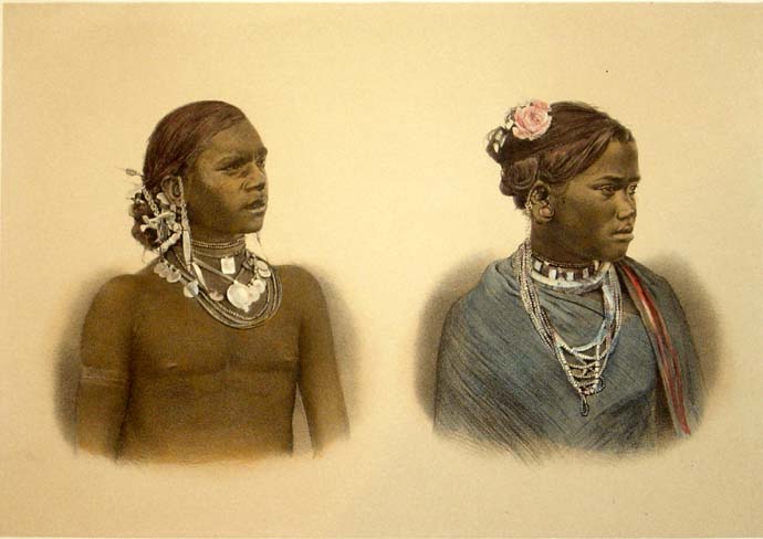
The Kurukh or Oraon, also spelt Uraon or Dhangad, ( Kurukh: ''Karḵẖ'' and ''Oṛāōn'') are a Dravidian speaking ethnolinguistic group inhabiting Chhotanagpur Plateau and adjoining areas - mainly the Indian states of Jharkhand, Odisha, Chhattisgarh, and West Bengal. They predominantly speak Kurukh as their native language, which belongs to the Dravidian language family. In Maharashtra, Oraon people are also known as Dhangad. Traditionally, Oraons depended on the forest and farms for their ritual practices and livelihoods, but in recent times, they have become mainly settled agriculturalists. Many Oraon migrated to tea gardens of Assam, West Bengal and Bangladesh as well as to countries like Fiji, Guyana, Trinidad and Tobago and Mauritius during British rule, where they were known as ''Hill Coolies''. They are listed as a Scheduled Tribe in seven Indian states for the purpose of reservation system. Etymology According to Edward Tuite Dalton, "Oraon" is an exonym assi ... [...More Info...] [...Related Items...] OR: [Wikipedia] [Google] [Baidu] |
Santal People
The Santal (or Santhal) are an Austroasiatic languages, Austroasiatic-speaking Munda peoples, Munda ethnic group of the Indian subcontinent. Santals are the largest tribe in the Jharkhand and West Bengal in terms of population and are also found in the states of Odisha, Bihar, Assam and Tripura. They are the largest ethnic minority in northern Bangladesh's Rajshahi Division and Rangpur Division. They have a sizeable population in Nepal. The Santals speak Santali language, Santali, the most widely spoken Munda languages of Austroasiatic languages, Austroasiatic language family. Etymology Santal is most likely derived from an exonym. The term refers to inhabitants of in erstwhile Silda, West Bengal, Silda in Midnapore, Medinapore region in West Bengal. The Sanskrit word ''Samant'' or Bengali ''Saont'' means plain land. Their ethnonym is ("child of human"). History Origins According to linguist Paul Sidwell, Austro-Asiatic language speakers probably arrived on the coast of Od ... [...More Info...] [...Related Items...] OR: [Wikipedia] [Google] [Baidu] |
2011 Bangladesh Census
In 2011, the Bangladesh Bureau of Statistics conducted a national census in Bangladesh, which provided a provisional estimate of the total population of the country as 142,319,000. The previous decennial census was the 2001 census. Data were recorded from all of the districts and upazilas and main cities in Bangladesh, including statistical data on population size, households, sex and age distribution, marital status, economically active population, literacy and educational attainment, religion, number of children etc. Bangladesh and India also conducted their first joint census of areas along their border in 2011. According to the census, Hindus constituted 8.5 per cent of the population as of 2011, down from 9.6 per cent in the 2001 census. Bangladesh has a population of 144,043,697 as per the 2011 census report. The majority of 130,201,097 reported that they were Muslim, 12,301,331 reported as Hindu, 864,262 as Buddhist, 532,961 as Christian and 201,661 as others. See als ... [...More Info...] [...Related Items...] OR: [Wikipedia] [Google] [Baidu] |
Christianity In Bangladesh
Christians in Bangladesh () account for 0.30% (accurately 488,583) of the nation's population according to the 2022 census in Bangladesh. Together with Buddhism in Bangladesh, Buddhism (plus other minority groups such as Irreligion in Bangladesh, Atheism, Sikhism in Bangladesh, Sikhism, the Bahá'í Faith and others), Christianity accounts for 1% of the population. Islam in Bangladesh, Islam accounts for 91.04% of the country's population, followed by Hinduism in Bangladesh, Hinduism at 7.95% according to the 2022 census. History The introduction and development of Christianity in the Indian subcontinent can be traced back to several periods, with the help of several countries and denominations. The earliest connection to Christianity can be linked back to the arrival of the Thomas the Apostle, Apostle Thomas to the Malabar Coast during the first century, in 52 A.D. In addition, the Apostle had managed to convert several thousands of Hindu Brahmins, as they were "attracted" to ... [...More Info...] [...Related Items...] OR: [Wikipedia] [Google] [Baidu] |
Hinduism In Bangladesh
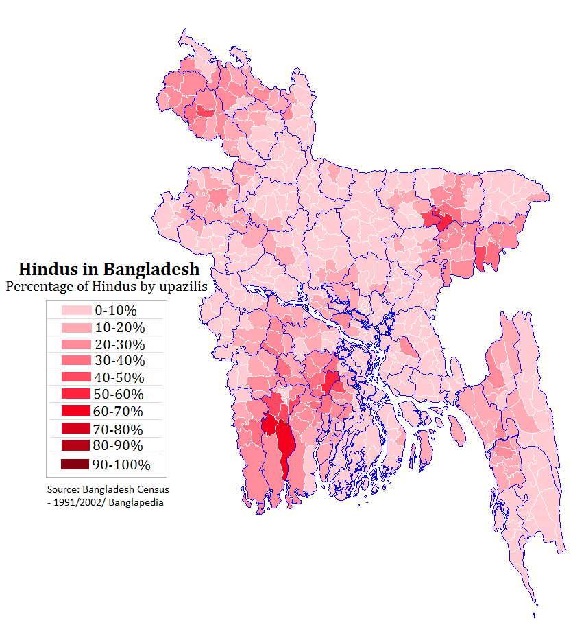
Hinduism is the second largest religion in Bangladesh, as according to the 2022 Census of Bangladesh, approximately 13.1 million people responded as Hindus, constituting 7.95% of the nation. Bangladesh is the third-largest Hindu populated country in the world, after India and Nepal. Hinduism is the Religion in Bangladesh, second-largest religion in 61 of 64 districts in Bangladesh, but there are no Hindu majority districts in Bangladesh. Demographics According to the 2001 Bangladesh census, there were around 11.82 million Hindus in Bangladesh constituting 9.6% of the population, which at the time was 123.15 million. The 2011 Bangladesh census, Bangladesh 2011 census states, that approximately 12.73 million people responded that they were Hindus, constituting 8.54% of the total 149.77 million. While 2022 Census of Bangladesh, put the number of Hindus in Bangladesh at 13.1 million out of total 165.1 million population, thus constituting 7.95% of the population. According to ... [...More Info...] [...Related Items...] OR: [Wikipedia] [Google] [Baidu] |
Islam In Bangladesh
Islam is the largest and the state religion of the People's Republic of Bangladesh. According to the 2022 census, Bangladesh had a population of about 150 million Muslims, or 91.04% of its total population of million. Muslims of Bangladesh are predominant native Bengali Muslims. The majority of Bangladeshis are ''Sunni'', and follow the '' Hanafi'' school of ''Fiqh''. Bangladesh is a ''de facto'' secular country. The Bengal region was a supreme power of the medieval Islamic East. In the late 7th century, Muslims from Arabia established commercial as well as religious connection within the Bengal region before the conquest, mainly through the coastal regions as traders and primarily via the ports of Chittagong. In the early 13th century, Muhammad bin Bakhtiyar Khalji conquered Western and part of Northern Bengal and established the first Muslim kingdom in Bengal. During the 13th century, Sufi missionaries, mystics and saints began to preach Islam in villages. The Islamic ... [...More Info...] [...Related Items...] OR: [Wikipedia] [Google] [Baidu] |
Patnitala Upazila
Patnitala Upazila () is an Upazila of Naogaon District in the Division of Rajshahi, Bangladesh. Geography Patnitala is located at . It has 58,661 units of households and total area 382.38 km2. The major rivers are the Atrai and the Shiba. Patnitala Upazila is bounded by Dhamoirhat Upazila and Tapan CD Block of Dakshin Dinajpur district, West Bengal, India, on the north, Badalgachhi on the east, Mohadevpur Upazila on the south and Porsha and Sapahar Upazilas on the west. Demographics According to the 2011 Census of Bangladesh, Patnitala Upazila had 58,661 households and a population of 231,900. 43,996 (18.97%) were under 10 years of age. Patnitala had a literacy rate (age 7 and over) of 52.55%, compared to the national average of 51.8%, and a sex ratio of 987 females per 1000 males. 21,670 (9.34%) lived in urban areas. Ethnic population was 20,270 (8.74%), of which Oraon were 6,552, Santal 5,375 and Barman 3,780. As of the 1991 Bangladesh census, Patnitala had a ... [...More Info...] [...Related Items...] OR: [Wikipedia] [Google] [Baidu] |


