|
Des Moines Metropolitan Area
The Des Moines metropolitan area, officially known as the Des Moines–West Des Moines, IA Metropolitan Statistical Area (MSA) is located at the confluence of the Des Moines River and the Raccoon River. Des Moines serves as the capital and largest city of the U.S. state of Iowa. The metro area consists of six counties in central Iowa: Polk County, Iowa, Polk, Dallas County, Iowa, Dallas, Warren County, Iowa, Warren, Madison County, Iowa, Madison, Guthrie County, Iowa, Guthrie, and Jasper County, Iowa, Jasper. The Des Moines, Iowa, Des Moines–Ames, Iowa, Ames–West Des Moines, Iowa, West Des Moines Combined Statistical Area (CSA) encompasses the separate metropolitan area of Ames (Story County, Iowa, Story Country), and the separate United States micropolitan area, micropolitan area of Boone, Iowa, Boone (Boone County, Iowa, Boone County). The Des Moines area is a fast-growing metro area. Demographics Des Moines–West Des Moines, IA Metropolitan Statistical Area Des Moines-A ... [...More Info...] [...Related Items...] OR: [Wikipedia] [Google] [Baidu] |
Polk County, Iowa
Polk County is located in the U.S. state of Iowa. As of the 2020 United States census, 2020 census, the population was 492,401. making it the List of counties in Iowa, most populous county in Iowa, and was estimated to be 505,255 in 2023. It is home to over 15% of the state's residents. The county seat is Des Moines, Iowa, Des Moines, which is also the capital city of Iowa. Polk County is included in the Des Moines–West Des Moines, Iowa, West Des Moines, IA Des Moines metropolitan area, Metropolitan Statistical Area. History On January 13, 1846, the legislative body of the Iowa Territory authorized the creation of twelve counties in the Territory, with general descriptions of their boundaries. On January 17 they further enacted a resolution setting the effective date of the county government for Jasper and Polk Counties as March 1, 1846. Polk County's name referred to United States President James K. Polk, who served from 1845 to 1849. The first courthouse, a two-story struct ... [...More Info...] [...Related Items...] OR: [Wikipedia] [Google] [Baidu] |
Indianola, Iowa
Indianola is city in and county seat of Warren County, Iowa, United States, located south of downtown Des Moines. The population was 15,833 at the time of the 2020 census. Indianola is home to the National Balloon Classic, a nine-day hot air balloon festival held annually in the summer, the Des Moines Metro Opera, a major American Summer Opera Festival, and Simpson College. History Indianola was founded in 1849 as the county seat of Warren County. The town was located near the geographic center of the new county. The town's name was taken from a newspaper account of a Texas ghost town of the same name. Indianola was incorporated in 1863. Geography According to the United States Census Bureau, the city has a total area of , all land. The Summerset Trail's southern terminus is in Indianola. Climate According to the Köppen climate classification system, Indianola has a hot-summer humid continental climate, abbreviated "Dfa" on climate maps. Demographics 2020 censu ... [...More Info...] [...Related Items...] OR: [Wikipedia] [Google] [Baidu] |
Adel, Iowa
Adel ( ) is a city in and the county seat of Dallas County, Iowa, United States. It is located along the Raccoon River, North Raccoon River. Its population was 6,153 at the time of the 2020 United States census, 2020 Census. History Adel is the oldest town within Dallas County. Originally called Penoach, Adel was incorporated in 1847, and changed to its current name in 1849. In 1855, there were about twenty-five houses in Adel and three stores. From that time onward, the city began to grow at a faster rate. Situated along the river, Adel had a good supply of water-power for a flour mill. It was to be situated on a section of property owned by Noeingerl Cantrel & Co. J. H. Strong of Des Moines, and H. H. Moffatt built the mill in 1856–57 at a cost of $20,000. The dam was constructed with about eight feet of head water. The mill was kept in good repair, able to average from twelve to fifteen bushels per hour, with a capability of thirty per hour, but was destroyed in 1913. The ... [...More Info...] [...Related Items...] OR: [Wikipedia] [Google] [Baidu] |
Boone County, Iowa
Boone County is a county in the U.S. state of Iowa. As of the 2020 census, the population was 26,715. Its county seat is Boone. Boone County comprises the Boone, IA Micropolitan Statistical Area, which is included in the Des Moines- Ames- West Des Moines, IA Combined Statistical Area. History The land that now forms Boone and several other Iowa counties was ceded by the Sac and Fox nation to the United States in a treaty signed on October 11, 1842. On January 13, 1846, the legislative body of the Indiana Territory authorized creation of twelve counties in the Iowa Territory, with general descriptions of their boundaries. Boone County's name referred to Captain Nathan Boone, son of Daniel Boone, an American pioneer who formed the Wilderness Trail and founded the settlement of Boonesborough, Kentucky. County residents selected Boonesboro as the county seat in 1851. The first building erected in the new settlement was a double log house, to be used as interim county offic ... [...More Info...] [...Related Items...] OR: [Wikipedia] [Google] [Baidu] |
Boone, Iowa
Boone ( ) is a city in Des Moines Township, Boone County, Iowa, Des Moines Township, and county seat of Boone County, Iowa, United States. It is the principal city of the Boone, Iowa Micropolitan Statistical Area, which encompasses all of Boone County. This micropolitan statistical area, along with the Ames, Iowa Metropolitan Statistical Area comprise the larger Ames-Boone, Iowa Combined Statistical Area. The population of the city was reported as 12,460 at the 2020 United States census, 2020 census. History Coal mining played an important part in the early history of the Boone area. Local blacksmiths were already mining coal from the banks of Honey Creek south of what became Boone in 1849. Boone was platted as a town in 1865 by John Insley Blair. It was incorporated the following year, when the Chicago and North Western Transportation Company railroad station was built there. The town was originally named "Montana"; it was renamed to Boone in 1871. The nearby town of Boonesbo ... [...More Info...] [...Related Items...] OR: [Wikipedia] [Google] [Baidu] |
Story County, Iowa
Story County is a County (United States), county in the U.S. state of Iowa. As of the 2020 United States census, 2020 census, the population was 98,537, making it the ninth-most populous county in Iowa. The county seat is Nevada, Iowa, Nevada; the largest city is Ames, Iowa, Ames. The geographical center of Iowa lies in Story County, northeast of Ames. Story County comprises the Ames, Iowa, Ames, IA Metropolitan Statistical Area, which is included in the Des Moines, Iowa, Des Moines-Ames, Iowa, Ames-West Des Moines, Iowa, West Des Moines, IA Des Moines metropolitan area, Combined Statistical Area. The county is home to Iowa State University in Ames. History The land that today is known as Story County was originally prairie with the exception of some groves along the larger streams in the area. In 1846 the boundaries of Story County were established. The county has an area of and is square in shape. The county was named after Joseph Story, a preeminent United States Supreme ... [...More Info...] [...Related Items...] OR: [Wikipedia] [Google] [Baidu] |
Ames, Iowa
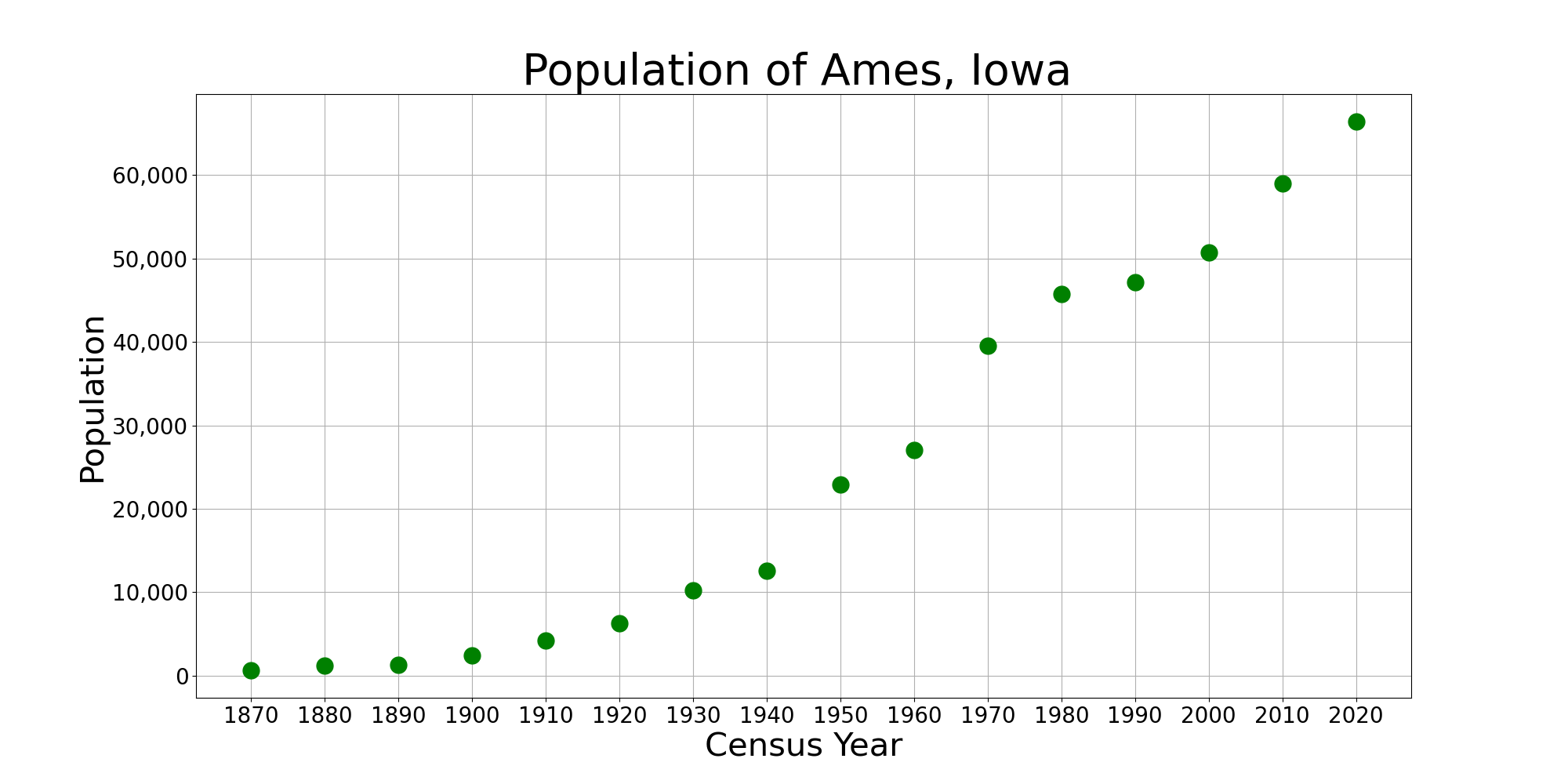
Ames () is a city in Story County, Iowa, United States, located approximately north of Des Moines, Iowa, Des Moines in central Iowa. It is the home of Iowa State University (ISU). According to the 2020 United States census, 2020 census, Ames had a population of 66,427, making it the state's List of cities in Iowa, ninth-most populous city. Iowa State University was home to 30,177 students as of fall 2023, which make up approximately one half of the city's population. A United States Department of Energy national laboratory, Ames Laboratory, is located on the ISU campus. Ames also hosts United States Department of Agriculture (USDA) sites: the largest federal animal disease center in the United States, the USDA Agricultural Research Service's National Animal Disease Center (NADC), as well as one of two national USDA sites for the Animal and Plant Health Inspection Service (APHIS), which comprises the National Veterinary Services Laboratory and the Center for Veterinary Biologics. ... [...More Info...] [...Related Items...] OR: [Wikipedia] [Google] [Baidu] |
Jasper County, Iowa
Jasper County is a county in the U.S. state of Iowa. As of the 2020 census, the population was 37,813. The county seat is Newton. The county was organized in 1846 and is named after Sergeant William Jasper, a Revolutionary War hero. Jasper County is part of the Des Moines– West Des Moines, IA Metropolitan Statistical Area. Geography According to the U.S. Census Bureau, the county has a total area of , of which is land and (0.3%) is water. The North and South Skunk River flow through the county. Bodies of water include Lake Mariposa and Rock Creek. Major highways * Interstate 80 * U.S. Highway 6 * U.S. Highway 65 * Iowa Highway 14 * Iowa Highway 117 * Iowa Highway 163 * Iowa Highway 224 * Iowa Highway 330 Transit Adjacent counties * Marshall County (north) * Poweshiek County (east) * Mahaska County (southeast) * Marion County (south) * Polk County (west) * Story County (northwest) Demographics 2020 census The 2020 census recorded a population ... [...More Info...] [...Related Items...] OR: [Wikipedia] [Google] [Baidu] |
Guthrie County, Iowa
Guthrie County is a county located in the U.S. state of Iowa. As of the 2020 census, the population was 10,623. The county seat is Guthrie Center. The county was formed on January 15, 1851, and named after Captain Edwin B. Guthrie, who died in the Mexican–American War. Guthrie County is one of the six counties that make up the Des Moines– West Des Moines, Iowa Metropolitan Statistical Area. Geography According to the U.S. Census Bureau, the county has a total area of , of which is land and (0.4%) is water. Example of native vegetation: https://commons.wikimedia.org/wiki/File:Whiterock_Conservancy_Neighborhood_New_Wiki_Version.JPG Major highways * Iowa Highway 4 * Iowa Highway 25 * Iowa Highway 44 * Iowa Highway 141 Adjacent counties * Greene County (north) * Dallas County (east) * Adair County (south) * Audubon County (west) * Carroll County (northwest) Demographics 2020 census The 2020 census recorded a population of 10,623 in the county, with a ... [...More Info...] [...Related Items...] OR: [Wikipedia] [Google] [Baidu] |


