|
Dall Island
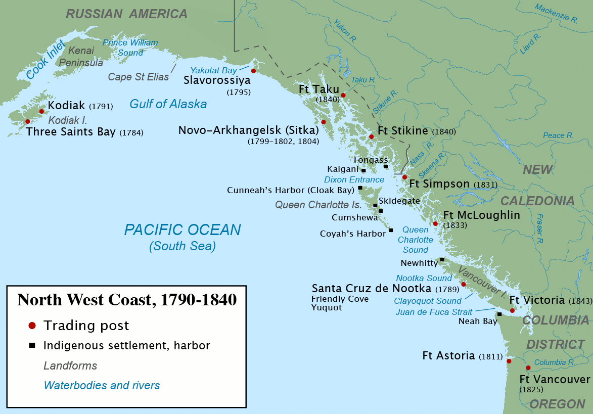
Dall Island is an island in the Alexander Archipelago off the southeast coast of Alaska, just west of Prince of Wales Island and north of Canadian waters. Its peak elevation is above sea level. Its land area is , making it the 28th largest island in the United States. Dall is used economically for fishing and limestone quarrying. Population and demographics The 2000 census recorded 20 persons living on the island. The Haida are known to have inhabited coastal caves on the island two to three thousand years ago. History Dall Island was first called "Quadra", after Juan Francisco de la Bodega y Quadra, until 1879, when it was renamed in honor of naturalist William H. Dall. The island also had been thought to be part of Prince of Wales Island as recently as 1903. During the maritime fur trade era several harbors on southeast Dall Island, collectively known as Kaigani, were among the most popular sites for trade between fur trading ships and the Kaigani Haida. Cape Muzon, ... [...More Info...] [...Related Items...] OR: [Wikipedia] [Google] [Baidu] |
Cordova Bay
Cordova Bay is a bay in the Alexander Archipelago of southeast Alaska. It opens onto Dixon Entrance to the south, between Cape Muzon on Dall Island and Point Marsh (a group of small islets just off Prince of Wales Island). The name Puerto Cordova y Cordova was given by the Spanish explorer Lieutenant Don Jacinto Caamaño in 1792, in honor of Admiral Luis de Córdova y Córdova. The name was published by George Vancouver in 1798. Cordova Bay is bordered on the west by Dall Island, Long Island, Tlevak Strait, and Sukkwan Island, and on the east by Prince of Wales Island. Cordova Bay extends north and west from its mouth to Lime Point, where it connects with Hetta Inlet. The Coast Survey lists the length as about from a point between the SE corner of Long Island and Dewey Rocks to Lime Point and an average width of about from Ship Islands to Lime Point. Hetta Inlet extends a further north, and then turns east for about . Gould Island almost closes the inlet shortly after it tur ... [...More Info...] [...Related Items...] OR: [Wikipedia] [Google] [Baidu] |
Maritime Fur Trade
The maritime fur trade was a ship-based fur trade system that focused on acquiring furs of sea otters and other animals from the indigenous peoples of the Pacific Northwest Coast and natives of Alaska. The furs were mostly sold in China in exchange for tea, silks, porcelain, and other Chinese goods, which were then sold in Europe and the United States. The maritime fur trade was pioneered by Russians, working east from Kamchatka along the Aleutian Islands to the southern coast of Alaska. British and Americans entered during the 1780s, focusing on what is now the coast of British Columbia. The trade boomed around the beginning of the 19th century. A long period of decline began in the 1810s. As the sea otter population was depleted, the maritime fur trade diversified and transformed, tapping new markets and commodities, while continuing to focus on the Northwest Coast and China. It lasted until the middle to late 19th century. Russians controlled most of the coast of present-d ... [...More Info...] [...Related Items...] OR: [Wikipedia] [Google] [Baidu] |
Islands Of Alaska ...
This is a list of islands of the U.S. state of Alaska. Approximately 2,670 named islands help to make Alaska the largest state in the United States. A B C D E F G H I J K L M N O P Q R S T U V W Y Z See also * List of lakes of Alaska * List of rivers of Alaska *List of waterfalls of Alaska Notes USGS GNIS named islands by Borough or Census Area: References General references * {{DEFAULTSORT:List Of Islands Of Alaska Islands * Alaska Alaska ( ; russian: Аляска, Alyaska; ale, Alax̂sxax̂; ; ems, Alas'kaaq; Yup'ik: ''Alaskaq''; tli, Anáaski) is a state located in the Western United States on the northwest extremity of North America. A semi-exclave of the U.S ... [...More Info...] [...Related Items...] OR: [Wikipedia] [Google] [Baidu] |
Islands Of Prince Of Wales–Hyder Census Area, Alaska
An island or isle is a piece of subcontinental land completely surrounded by water. Very small islands such as emergent land features on atolls can be called islets, skerries, cays or keys. An island in a river or a lake island may be called an eyot or ait, and a small island off the coast may be called a holm. Sedimentary islands in the Ganges Delta are called chars. A grouping of geographically or geologically related islands, such as the Philippines, is referred to as an archipelago. There are two main types of islands in the sea: continental islands and oceanic islands. There are also artificial islands (man-made islands). There are about 900,000 official islands in the world. This number consists of all the officially-reported islands of each country. The total number of islands in the world is unknown. There may be hundreds of thousands of tiny islands that are unknown and uncounted. The number of sea islands in the world is estimated to be more than 200,000. The ... [...More Info...] [...Related Items...] OR: [Wikipedia] [Google] [Baidu] |
Dall Island Heli
Dall may refer to: People *Anders Bendssøn Dall (died 1607), Danish Lutheran bishop *Bobby Dall (born 1963), American musician *Caroline Healey Dall (1822–1912), American feminist writer * Clarrie Dall (1887–1953), Australian footballer *Curtis Bean Dall (1896–1991), American businessman and author *Cynthia Dall, (1971–2012) American musician *Evelyn Dall (1918–2010), American singer and actress *Ferdomhnach Dall (died 1110), Lector of Kildare and harpist * James Kyle Dall, first headmaster of Elmfield College *John Dall (1920–1971), American actor *Karl Dall (1941–2020), German television presenter * Nicholas Thomas Dall (died 1777), Danish painter * Niels Dall (born 1984), Danish archer *Rose Datoc Dall (born 1968), Filipina-American artist *William Healey Dall (1845–1927), American naturalist and malacologist * Dall Fields (1889–1956) Places *Dall Island, an island in the Alexander Archipelago * Dall Lake, a lake in Alaska, United States *Dall River Old Growth ... [...More Info...] [...Related Items...] OR: [Wikipedia] [Google] [Baidu] |
Portland Canal
, image = Hyder Alaska IMG 0276 (22495379342).jpg , alt = , caption = Portland Canal from Hyder, Alaska , image_bathymetry = , alt_bathymetry = , caption_bathymetry = , location = Alaska and British Columbia , group = , coordinates = , type = Fjord , etymology = , part_of = Portland Inlet , inflow = , rivers = , outflow = , oceans = , catchment = , basin_countries = Canada and United States , agency = , designation = , date-built = , engineer = , date-flooded = , length = , width = , area = , depth = , max-depth = , volume = , residence_time = , salinity = , shore = , elevation = , temperature_high = , temperature_low = , frozen = , islands = , islands_category = , sections = , trenches = , benches = , cities = , pushpin_map = Canada British Columbia , pushpin_label_position = , pushpin_map_alt = , pushpin_map_caption = , website = , reference = Portland Canal is an arm of Portland Inlet ... [...More Info...] [...Related Items...] OR: [Wikipedia] [Google] [Baidu] |
Treaty Of Saint Petersburg (1825)
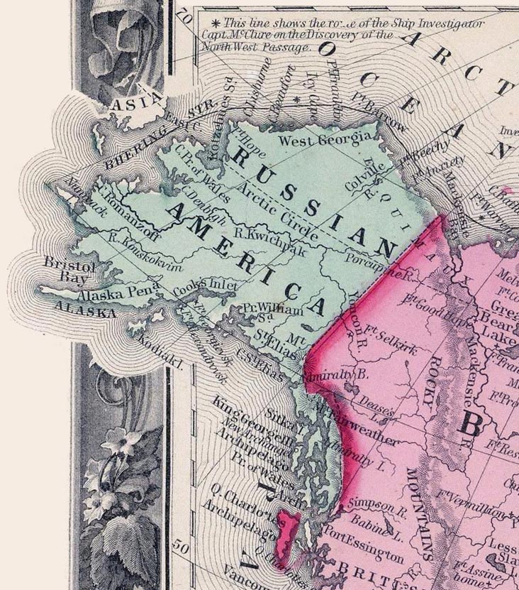
The Treaty of Saint Petersburg of 1825 or the Anglo-Russian Convention of 1825, officially the Convention Concerning the Limits of Their Respective Possessions on the Northwest Coast of America and the Navigation of the Pacific Ocean, defined the boundaries between Russian America and British claims and possessions of the Pacific Coast, and the later Yukon and Arctic regions of North America. It was agreed that along the coast at the southern tip of Prince of Wales island (now known as parallel 54°40′ north) northward to the 56 parallel, with the island wholly belonging to Russia, then to 10 marine leagues () inland going north and west to the 141st meridian west and then north to the "Frozen Ocean", the current Alaska/Canadian Yukon boundary, would be the boundary. The coastal limit had, the year before, been established as the limit of overlapping American claims in the parallel Russo-American Treaty of 1824. The Russian sphere in the region was later sold to the United State ... [...More Info...] [...Related Items...] OR: [Wikipedia] [Google] [Baidu] |
Dixon Entrance
The Dixon Entrance (french: Entrée Dixon) is a strait about long and wide in the Pacific Ocean at the Canada–United States border, between the U.S. state of Alaska and the province of British Columbia in Canada. The Dixon Entrance is part of the Inside Passage shipping route. It forms part of the maritime boundary between the U.S. and Canada, although the location of that boundary here is disputed. Etymology The strait was named by Joseph Banks for Captain George Dixon, a Royal Navy officer, fur trader, and explorer, who surveyed the area in 1787. Geography The Dixon Entrance lies between Clarence Strait in the Alexander Archipelago in Alaska to the north, and Hecate Strait and the islands known as Haida Gwaii (the Queen Charlotte Islands) in British Columbia British Columbia (commonly abbreviated as BC) is the westernmost Provinces and territories of Canada, province of Canada, situated between the Pacific Ocean and the Rocky Mountains. It has a diverse geography ... [...More Info...] [...Related Items...] OR: [Wikipedia] [Google] [Baidu] |
Hay-Herbert Treaty
The Alaska boundary dispute was a territorial dispute between the United States and the United Kingdom of Great Britain and Ireland, which then controlled Canada's foreign relations. It was resolved by arbitration in 1903. The dispute had existed between the Russian Empire and Britain since 1821, and was inherited by the United States as a consequence of the Alaska Purchase in 1867. The final resolution favored the American position, as Canada did not get an all-Canadian outlet from the Yukon gold fields to the sea. The disappointment and anger in Canada was directed less at the United States, and more at the British government for betraying Canadian interests in favor of healthier Anglo-American relations. Background 1825–1898 In 1825 Russia and the United Kingdom signed a treaty to define the borders of their respective colonial possessions, the Anglo-Russian Convention of 1825. Part of the wording of the treaty was that: The vague phrase "the mountains parallel to the ... [...More Info...] [...Related Items...] OR: [Wikipedia] [Google] [Baidu] |
British Columbia
British Columbia (commonly abbreviated as BC) is the westernmost Provinces and territories of Canada, province of Canada, situated between the Pacific Ocean and the Rocky Mountains. It has a diverse geography, with rugged landscapes that include rocky coastlines, sandy beaches, forests, lakes, mountains, inland deserts and grassy plains, and borders the province of Alberta to the east and the Yukon and Northwest Territories to the north. With an estimated population of 5.3million as of 2022, it is Canada's Population of Canada by province and territory, third-most populous province. The capital of British Columbia is Victoria, British Columbia, Victoria and its largest city is Vancouver. Vancouver is List of census metropolitan areas and agglomerations in Canada, the third-largest metropolitan area in Canada; the 2021 Canadian census, 2021 census recorded 2.6million people in Metro Vancouver Regional District, Metro Vancouver. The First Nations in Canada, first known human inhabi ... [...More Info...] [...Related Items...] OR: [Wikipedia] [Google] [Baidu] |


