|
Dales Radio
Dales Radio is a community radio station broadcasting in the Yorkshire Dales in Northern England, to communities including Hawes, Sedbergh, Grassington, Settle, Ingleton and Leyburn. It is the largest community radio station in the United Kingdom in terms of the extent of its broadcast area, but one of the smallest in terms of population. History Dales Radio launched on 11 January 2016, following the closure in 2012 of Fresh Radio, a commercial radio station covering the Yorkshire Dales area. A number of presenters and staff at Dales Radio were previously involved with Fresh Radio. In 2021, the station began to expand its coverage across the Yorkshire Dales National Park. This involves installing new transmitter sites in unserved parts of the region. A new transmitter at Leyburn, on 104.9 FM, went live on 2 April 2021. Programming Dales Radio is a not-for-profit community radio station and aims to enhance the lives of those living in and visiting the Yorkshire Dales Nationa ... [...More Info...] [...Related Items...] OR: [Wikipedia] [Google] [Baidu] |
FM Broadcasting
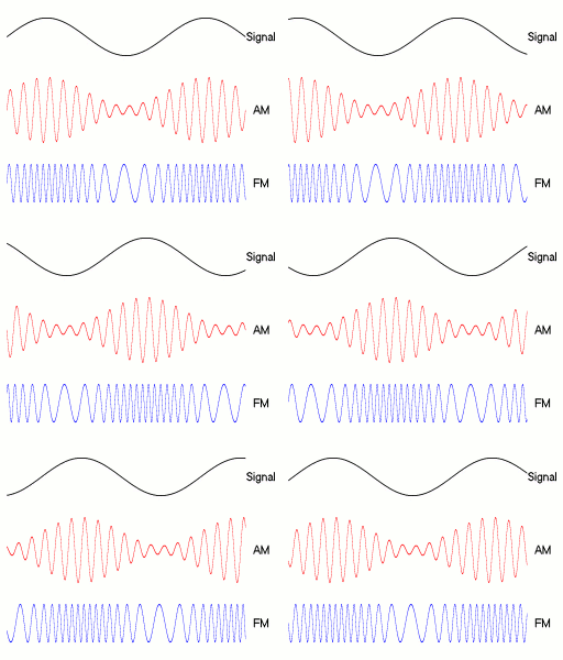
FM broadcasting is a method of radio broadcasting using frequency modulation (FM). Invented in 1933 by American engineer Edwin Armstrong, wide-band FM is used worldwide to provide high fidelity sound over broadcast radio. FM broadcasting is capable of higher fidelity—that is, more accurate reproduction of the original program sound—than other broadcasting technologies, such as AM broadcasting. It is also less susceptible to common forms of interference, reducing static and popping sounds often heard on AM. Therefore, FM is used for most broadcasts of music or general audio (in the audio spectrum). FM radio stations use the very high frequency range of radio frequencies. Broadcast bands Throughout the world, the FM broadcast band falls within the VHF part of the radio spectrum. Usually 87.5 to 108.0 MHz is used, or some portion thereof, with few exceptions: * In the former Soviet republics, and some former Eastern Bloc countries, the older 65.8–74 M ... [...More Info...] [...Related Items...] OR: [Wikipedia] [Google] [Baidu] |
Ingleton, North Yorkshire
Ingleton is a village and civil parish in the Craven district of North Yorkshire, England. The village is from Kendal and from Lancaster on the western side of the Pennines. It is from Settle. The River Doe and the River Twiss meet to form the source of the River Greta, a tributary of the River Lune. The village is on the A65 road and at the head of the A687. The B6255 takes the south bank of the River Doe to Ribblehead and Hawes. All that remains of the railway in the village is the landmark Ingleton Viaduct.OS map 98, Wensleydale and Upper Wharfdale. Arthur Conan Doyle was a regular visitor to the area and was married locally, as his mother lived at Masongill from 1882 to 1917 (see notable people). It has been claimed that there is evidence that the inspiration for the name Sherlock Holmes came from here. Whernside, north-north-east of the village, one of the Yorkshire Three Peaks, is the highest point in the parish at . There are major quarries within the pa ... [...More Info...] [...Related Items...] OR: [Wikipedia] [Google] [Baidu] |
Radio Stations Established In 2016
Radio is the technology of signaling and communicating using radio waves. Radio waves are electromagnetic waves of frequency between 30 hertz (Hz) and 300 gigahertz (GHz). They are generated by an electronic device called a transmitter connected to an antenna which radiates the waves, and received by another antenna connected to a radio receiver. Radio is very widely used in modern technology, in radio communication, radar, radio navigation, remote control, remote sensing, and other applications. In radio communication, used in radio and television broadcasting, cell phones, two-way radios, wireless networking, and satellite communication, among numerous other uses, radio waves are used to carry information across space from a transmitter to a receiver, by modulating the radio signal (impressing an information signal on the radio wave by varying some aspect of the wave) in the transmitter. In radar, used to locate and track objects like aircraft, ships, spacecraft ... [...More Info...] [...Related Items...] OR: [Wikipedia] [Google] [Baidu] |
Effective Radiated Power
Effective radiated power (ERP), synonymous with equivalent radiated power, is an IEEE standardized definition of directional radio frequency (RF) power, such as that emitted by a radio transmitter. It is the total power in watts that would have to be radiated by a half-wave dipole antenna to give the same radiation intensity (signal strength or power flux density in watts per square meter) as the actual source antenna at a distant receiver located in the direction of the antenna's strongest beam ( main lobe). ERP measures the combination of the power emitted by the transmitter and the ability of the antenna to direct that power in a given direction. It is equal to the input power to the antenna multiplied by the gain of the antenna. It is used in electronics and telecommunications, particularly in broadcasting to quantify the apparent power of a broadcasting station experienced by listeners in its reception area. An alternate parameter that measures the same thing is e ... [...More Info...] [...Related Items...] OR: [Wikipedia] [Google] [Baidu] |
Yorkshire Dales National Park
The Yorkshire Dales National Park is a national park in England covering most of the Yorkshire Dales. Most of the park is in North Yorkshire, with a sizeable area in Westmorland (Cumbria) and a small part in Lancashire. The park was designated in 1954, and extended in 2016. Over 95% of the land in the Park is under private ownership; there are over 1,000 farms in this area. In late 2020, the park was named as an International Dark Sky Reserve. This honour confirms that the area has "low levels of light pollution with good conditions for astronomy". Some 23,500 residents live in the park (as of 2017); a 2018 report estimated that the Park attracted over four million visitors per year. The economy consists primarily of tourism and agriculture. Location The park is north-east of Manchester; Otley, Ilkley, Leeds and Bradford lie to the south, while Kendal is to the west, Darlington to the north-east and Harrogate to the south-east. The national park does not include ... [...More Info...] [...Related Items...] OR: [Wikipedia] [Google] [Baidu] |
Fresh Radio
Fresh Radio was a local radio station broadcasting to the Yorkshire Dales in northern England on two medium wave (AM) frequencies and three FM frequencies. It was also heard online via the Fresh Radio website. Transmission Two of the three AM frequencies were originally to be switched off by April 2007 and replaced by FM transmitters in Skipton, Ilkley, Pateley Bridge, Settle, Richmond and Grassington. The FM transmitter for Richmond on 102.6 FM commenced broadcasts on 11 February 2007 on 102.6 FM, however the rollout elsewhere was delayed, and AM kept being broadcast in Richmond, alongside the FM frequency. The Ilkley transmitter also began broadcasting on 107.1 FM as of 18 February 2007, a frequency also used by the former AM Pateley Bridge transmitter, while AM broadcasting continued on 936 AM covering Wensleydale, 1413 AM from Skipton and 1431 AM from Settle. The station's main studio was based at Broughton Hall near Skipton. Fresh R ... [...More Info...] [...Related Items...] OR: [Wikipedia] [Google] [Baidu] |
Leyburn
Leyburn is a market town and civil parish in the district of Richmondshire, North Yorkshire, England, sitting above the northern bank of the River Ure in Wensleydale. Historically in the North Riding of Yorkshire, the name was derived from 'Ley' or 'Le' (clearing), and 'burn' (stream), meaning clearing by the stream. Leyburn had a population of 1,844 at the 2001 census increasing to 2,183 at the 2011 Census. The estimated population in 2015 was 2,190. History Leyburn was mentioned in the Domesday Book of 1086 but had no recorded population; the growth of Leyburn as a major hub is linked to the decline in fortunes of nearby Wensley, which had prominence as the only market town in Wensleydale until being devastated by the plague in 1563, leaving what was once an important and prosperous town, mostly abandoned. Leyburn's stature increased in the 17th century when a market charter was granted by Charles II in 1686. Leyburn Town Hall was built in 1856 by Lord Bolton, and ... [...More Info...] [...Related Items...] OR: [Wikipedia] [Google] [Baidu] |
Settle, North Yorkshire
Settle is a market town and civil parish in the Craven district of North Yorkshire, England. Historically in the West Riding of Yorkshire, it is served by Settle railway station located near the town centre, and Giggleswick railway station which is a mile away. It is from Leeds Bradford Airport. The main road through Settle is the B6480, which links to the A65, connecting Settle to Leeds, Ilkley, Skipton and Kendal. The town had a population of 2,421 in the 2001 Census, increasing to 2,564 at the 2011 Census. History Settle is thought to have 7th-century Anglian origins, its name being the Angle word for settlement. Craven in the ''Domesday Book'' shows that until 1066 Bo was the lord of Settle but after the Harrying of the North (1069–1071) the land was granted to Roger de Poitou. In 1249 a market charter was granted to Henry de Percy, 7th feudal baron of Topcliffe by Henry III. A market square developed and the main route through the medieval town was aligned on ... [...More Info...] [...Related Items...] OR: [Wikipedia] [Google] [Baidu] |
AM Broadcasting
AM broadcasting is radio broadcasting using amplitude modulation (AM) transmissions. It was the first method developed for making audio radio transmissions, and is still used worldwide, primarily for medium wave (also known as "AM band") transmissions, but also on the longwave and shortwave radio bands. The earliest experimental AM transmissions began in the early 1900s. However, widespread AM broadcasting was not established until the 1920s, following the development of vacuum tube receivers and transmitters. AM radio remained the dominant method of broadcasting for the next 30 years, a period called the " Golden Age of Radio", until television broadcasting became widespread in the 1950s and received most of the programming previously carried by radio. Subsequently, AM radio's audiences have also greatly shrunk due to competition from FM (frequency modulation) radio, Digital Audio Broadcasting (DAB), satellite radio, HD (digital) radio, Internet radio, music streaming se ... [...More Info...] [...Related Items...] OR: [Wikipedia] [Google] [Baidu] |
Grassington
Grassington is a market town and civil parish in the Craven district of North Yorkshire, England. The population of the parish at the 2011 Census was 1,126. Historically part of the West Riding of Yorkshire, the town is situated in Wharfedale, about north-west from Bolton Abbey, and is surrounded by limestone scenery. Nearby villages include Linton, Threshfield, Hebden, Conistone and Kilnsey. History The Domesday Book lists Grassington as part of the estate of Gamal Barn including 7 carucates of ploughland (840 acres/350ha) including Grassington, Linton and Threshfield. The Norman conquest of England made it part of the lands of Gilbert Tison. But, by 1118, Tison had suffered a demotion and his lands returned to the king before being given to Lord Percy. Originally the settlement was spelt as Gherinstone and also was documented as Garsington or Gersington. The name Grassington derives variously from the Scandinavian, Anglo-Saxon and Gothic languages, and means eit ... [...More Info...] [...Related Items...] OR: [Wikipedia] [Google] [Baidu] |
Sedbergh
Sedbergh ( or ) is a town and civil parish in Cumbria, England. The 2001 census gave the parish a population of 2,705, increasing at the 2011 census to 2,765. Historically in the West Riding of Yorkshire, it lies about east of Kendal, north of Lancaster and about north of Kirkby Lonsdale, just within the Yorkshire Dales National Park. It stands at the foot of Howgill Fells, on the north bank of the River Rawthey, which joins the River Lune below the town. Situation Sedbergh has a narrow main street lined with shops. From all angles, the hills rising behind the houses can be seen. Until the coming of the Ingleton Branch Line in 1861, these remote places were reachable only by walking over some steep hills. The line to Sedbergh railway station ran from 1861 to 1954. The civil parish covers a large area, including the hamlets of Millthrop, Catholes, Marthwaite, Brigflatts, High Oaks, Howgill, Lowgill and Cautley, the southern part of the Howgill Fells and the wes ... [...More Info...] [...Related Items...] OR: [Wikipedia] [Google] [Baidu] |


