|
Natural Disasters In Indonesia
Natural disasters in Indonesia can usefully be divided into major disasters, medium level disasters, and lesser disasters which although causing less damage are very common across Indonesia. These can conveniently be considered as macro, mezzo, and micro events. Policies to respond deal with each of these different types of disasters. The official website of thIndonesian National Disaster Mitigation Agency(''Badan Nasional Penanggulangan Bencana'') provides frequent updates on disasters occurring in Indonesia. Major natural disasters with widespread loss of life The following is a list of main natural disasters that have occurred in Indonesia during recent history which have led to major loss of life (broadly defined here as over 500 deaths in the disaster). (1) Total death toll unknown. The eruption is believed to have had a worldwide impact. (2) This is the estimated death toll from the direct impact of the eruption. A total of perhaps 70,000 people are estimated to have d ... [...More Info...] [...Related Items...] OR: [Wikipedia] [Google] [Baidu] |
Krakatoa Eruption Lithograph
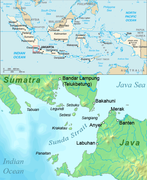
Krakatoa (), also transcribed (), is a caldera in the Sunda Strait between the islands of Java and Sumatra in the Indonesian province of Lampung. The caldera is part of a volcanic island group (Krakatoa archipelago) comprising four islands. Two of them are known as Lang Island, Lang and Verlaten Island, Verlaten; another, Rakata, is the only remnant of an island mostly destroyed by an 1883 eruption of Krakatoa, eruption in 1883 which created the caldera. In 1927, a fourth island, Anak Krakatoa, or "Child of Krakatoa", emerged from the caldera formed in 1883. There has been new eruptive activity since the late 20th century, with a large collapse causing 2018 Sunda Strait tsunami, a deadly tsunami in December 2018. Historical significance The most notable eruptions of Krakatoa culminated in a series of massive explosions over 26–27 August 1883, which were among the most violent volcanic events in recorded history. With an estimated Volcanic explosivity index (VEI) of 6, t ... [...More Info...] [...Related Items...] OR: [Wikipedia] [Google] [Baidu] |
Bengkulu
Bengkulu (), historically known as Bencoolen, is a province of Indonesia. It is located on the southwest coast of Sumatra. It was formed on 18 November 1968 by separating out the area of the historic Bencoolen Residency from the province of South Sumatra under Law No. 9 of 1967 and was finalized by Government Regulation No. 20 of 1968. Spread over 20,181.53 km2, its land area is comparable to the European country of Slovenia and it is bordered by the provinces of West Sumatra to the north, Jambi to the northeast, Lampung to the southeast, and South Sumatra to the east, and by the Indian Ocean to the northwest, south, southwest, and west. Bengkulu is the 28th largest province by area; it is divided into nine regencies and the city of Bengkulu, the capital and the only independent city. Bengkulu is also the 26th largest province by population in Indonesia, with 1,715,518 inhabitants at the 2010 CensusBiro Pusat Statistik, Jakarta, 2011. and 2,010,670 at the 2020 Census;B ... [...More Info...] [...Related Items...] OR: [Wikipedia] [Google] [Baidu] |
West Papua (region)
Western New Guinea, also known as Papua, Indonesian New Guinea, and Indonesian Papua, is the western half of the island of New Guinea, formerly Dutch and granted to Indonesia in 1962. Given the island is alternatively named Papua, the region is also called West Papua (). It is one of the seven geographical units of Indonesia in ISO 3166-2:ID. Lying to the west of Papua New Guinea and geographically a part of the Australian continent, the territory is almost entirely in the Southern Hemisphere and includes the Biak and Raja Ampat archipelagoes. The region is predominantly covered with rainforest where traditional peoples live, including the Dani of the Baliem Valley. A large proportion of the population live in or near coastal areas. The largest city is Jayapura. The island of New Guinea has been populated for tens of thousands of years. European traders began frequenting the region around the late 16th century due to spice trade. In the end, the Dutch Empire emerge ... [...More Info...] [...Related Items...] OR: [Wikipedia] [Google] [Baidu] |
1917 Bali Earthquake
The 1917 Bali earthquake occurred at 06:50 local time on 21 January (23:11 on 20 January UTC). It had an estimated magnitude of 6.6 on the surface-wave magnitude scale and had a maximum perceived intensity of IX (''Violent'') on the Mercalli intensity scale. It caused widespread damage across Bali, particularly in the south of the island. It triggered many landslides, which caused 80% of the 1,500 casualties. Tectonic setting The island of Bali forms part of the Sunda Arc, which formed above the convergent boundary where the Australian plate is subducting beneath the Sunda plate. The rate of convergence across the line of the Sunda–Java Trench is 7.5 cm per year. Eastwards from Bali, the Sunda Arc is also being thrust over the Bali and Flores back-arc basins on a series of south-dipping thrusts. Focal mechanisms for earthquakes near Bali are dominantly thrust sense on both the subduction interface and the system of thrust faults to the north. Earthquake The ear ... [...More Info...] [...Related Items...] OR: [Wikipedia] [Google] [Baidu] |
Maluku (province)
Maluku is located in Eastern Indonesia and geographically located in West-Melanesia, between Sulawesi and Western New Guinea, and comprises the central and southern regions of the Maluku Islands. It is directly adjacent to North Maluku, Southwest Papua, and West Papua (province), West Papua in the north, Central Sulawesi, and Southeast Sulawesi in the west, the Banda Sea, Australia, Timor-Leste and East Nusa Tenggara in the south and the Arafura Sea, Central Papua and South Papua in the east. The land area is 46,158.26 km2, and the total population of this province at the 2010 census was 1,533,506 people,Biro Pusat Statistik, Jakarta, 2011. rising to 1,848,923 at the 2020 census,Badan Pusat Statistik, Jakarta, 2021. the official estimate as at mid 2024 was 1,945,648 (comprising 983,943 males and 961,705 females).Badan Pusat Statistik, Jakarta, 28 February 2025, ''Provinsi Maluku Dalam Angka 2025'' (Katalog-BPS 1102001.81) The largest city and capital of Maluku province is A ... [...More Info...] [...Related Items...] OR: [Wikipedia] [Google] [Baidu] |
Seram Island
Seram (formerly spelled Ceram; also Seran or Serang) is the largest and main island of Maluku province of Indonesia, despite Ambon Island's historical importance. It is located just north of the smaller Ambon Island and a few other adjacent islands, such as Saparua, Haruku, Nusa Laut and the Banda Islands. Geography and geology Seram is traversed by a central mountain range, the highest point of which, Mount Binaiya, is covered with dense rain forests. Its remarkably complex geology is because of its location at the meeting of several tectonic microplates, which have been described as "one of the most tectonically complex areas on Earth". Seram falls on its microplate, which has been twisted around by 80° in the last 8 million years by the relatively faster movement of the Papua microplate. Meanwhile, along with the northward push of the Australian Plate, this has resulted in the uplift that gives north-central Seram peaks of over 3000 m. On the island, there are import ... [...More Info...] [...Related Items...] OR: [Wikipedia] [Google] [Baidu] |
1899 Ceram Earthquake
On 30 September 1899 the island of Ceram, Dutch East Indies, was struck by an Ms 7.8 earthquake which was accompanied by a 10-meter landslide-induced tsunami. According to the Batavian Magnetic and Meteorological Observatory, the shock occurred at 01:42 AM Amahei local time.Dr. R. D. M. Verbeek, ''Kort verslag over de aard- en zeebeving op Ceram, den 30sten september 1899'' (Batavia Landsdrukkerij, 1900) p. 1–11. The study about the quake and its effects was published by Dr. R. D. M. Verbeek in an article named ''Short Report about the earth- and sea-quake in Ceram, the 30th September 1899'', which serves as the only extensive source on this earthquake. Earthquake and tsunamis The Ceram earthquake is ranked among the tectonic quakes. The epicenter The epicenter (), epicentre, or epicentrum in seismology is the point on the Earth's surface directly above a hypocenter or focus, the point where an earthquake or an underground explosion originates. Determination The ... [...More Info...] [...Related Items...] OR: [Wikipedia] [Google] [Baidu] |
North Sulawesi
North Sulawesi () is a Provinces of Indonesia, province of Indonesia. It is mainly located on the Minahasa Peninsula of the island of Sulawesi, south of the Philippines and southeast of Sabah, Malaysia, but also includes various small archipelagoes situated between the Minahasa Peninsula and southern Philippines. It borders the Philippines province of Davao Occidental and Soccsksargen, Soccsksargen regions to the north, the Maluku Sea to the east, Gorontalo (its sole land border) and the Celebes Sea to the west and the Gulf of Tomini to the southwest. The province's furthest extent, the outlying and isolated island of Miangas to its north, is the northernmost island of Indonesia that has the country's sole and only border with the Philippines. The province's area is , and its population was 2,270,596 according to the 2010 census;Biro Pusat Statistik, Jakarta, 2011. this rose to 2,621,923 at the 2020 Census,Badan Pusat Statistik, Jakarta, 2021. while the official estimate as at ... [...More Info...] [...Related Items...] OR: [Wikipedia] [Google] [Baidu] |
Mount Awu
Mount Awu () is the largest stratovolcano in the Sangihe Islands chain, located on Sangir Island in North Sulawesi, Indonesia. Powerful eruptions have occurred in 1711, 1812, 1856, 1822, 1892, and 1966 with devastating pyroclastic flows and lahars that resulted in 11,048 fatalities. A total of 18 eruptions are recorded from 1640, with two of VEI 4 (1812 and 1966) and 3 with VEI 3 (1711, 1856 and 1892), one eruption every ~ 20 years. The hazardous nature of the volcano is determined from the continuous lava source driven by the geodynamic setting (a double subduction line that creates an arc–arc collision) and the presence of a crater lake, sustained by the consistent rainfall on the island, on top of a lava dome. This setting creates the conditions for water injection in the lava dome, which can cause a water-magma explosion. A 4.5 km wide crater is found at the summit and a deep valley forms a passageway for lahars, splitting the flanks from the crater. This is a vo ... [...More Info...] [...Related Items...] OR: [Wikipedia] [Google] [Baidu] |
Lampung
Lampung, officially the Province of Lampung (; ), is a province of Indonesia. It is located on the southern tip of the island of Sumatra. It has a short border with the province of Bengkulu to the northwest, and a longer border with the province of South Sumatra to the north, as well as a maritime border with the provinces of Banten and Jakarta to the east. It is the home of the Lampung people, who speak their own language and possess their own written script. Its capital city is Bandar Lampung. The province covers a land area of 33,575.41 km2 and had a population of 7,608,405 at the 2010 census,Biro Pusat Statistik, Jakarta, 2011. 9,007,848 at the 2020 census,Badan Pusat Statistik, Jakarta, 2021. and 9,313,990 (4,760,260 males and 4,553,720 females) according to the official estimates for mid-2023, with three-quarters of that being descendants of Javanese, Madurese and Balinese migrants. These migrants came from more densely populated islands in search of available lan ... [...More Info...] [...Related Items...] OR: [Wikipedia] [Google] [Baidu] |
Sunda Strait
The Sunda Strait () is the strait between the Indonesian islands of Java island, Java and Sumatra. It connects the Java Sea with the Indian Ocean. Etymology The strait takes its name from the Sunda Kingdom, which ruled the western portion of Java (an area covering the present day West Java, Jakarta, Banten, and some of western Central Java) from 669 to around 1579."Sunda Islands". Concise Dictionary of World Place-Names. John Everett-Heath. Oxford University Press 2005. Oxford Reference Online. Oxford University Press. The name also alludes to the Sundanese people native to West Java and Banten. Geography Extending in a roughly southwest/northeast orientation, with a minimum width of at its northeastern end between Cape Tua on Sumatra and Cape Pujat on Java, the strait is part of the Java Sea. It is essentially triangular in shape, with two large bays on its northern side. It is also very broad and deep at its southwestern end, but as it narrows to the northeast it becomes mu ... [...More Info...] [...Related Items...] OR: [Wikipedia] [Google] [Baidu] |
1883 Eruption Of Krakatoa
Beginning on 20 May 1883, and ending on 21 October 1883, the volcanic island of Krakatoa, located in the Sunda Strait, had repeated, months long Types of volcanic eruptions, volcanic eruptions. The most destructive of these eruptions occurred on 27 August, when over 70% of the island and its Krakatoa archipelago, surrounding archipelago were destroyed when it erupted so violently it collapsed itself into a caldera. The August eruption had an estimated Volcanic explosivity index, Volcanic Explosivity Index (VEI) of 6, and is List of volcanic eruptions by death toll, one of the deadliest and most destructive volcanic events in recorded history. The explosion was heard away in Perth, Western Australia, and Rodrigues near Mauritius, away. The acoustic pressure wave circled the globe more than three times. At least 36,417 deaths are attributed to the eruption and the tsunamis it created. Significant additional effects were felt worldwide in the days and weeks after the volcano's e ... [...More Info...] [...Related Items...] OR: [Wikipedia] [Google] [Baidu] |


