|
Cynwyd Heritage Trail
The Cynwyd Heritage Trail is a 1.8-mile rail trail in Lower Merion, Pennsylvania, on Philadelphia's Main Line. The trail surface is partially asphalt and crushed stone. It follows the former SEPTA Cynwyd Line railway line from Cynwyd station to Belmont Avenue, with a branch to Philadelphia's Manyunk neighborhood via the Manayunk Bridge over the Schuylkill River. The bridge, also a rail-to-trail conversion, reopened in October 2015 after a renovation. The first pedestrian/cyclist-only bridge over the river, it connects to Schuylkill River Trail The Schuylkill River Trail ( , ) is a multi-use trail along the banks of the Schuylkill River in southeastern Pennsylvania. Partially complete, the trail is ultimately planned to run about from the river's headwaters in Schuylkill County, Penns ... on the Philadelphia side. Volunteers had for years maintained a trail along the former railroad right-of-way. In 2008, the Friends of the Cynwyd Heritage Trail organized as a volunteer gro ... [...More Info...] [...Related Items...] OR: [Wikipedia] [Google] [Baidu] |
Cynwyd Line
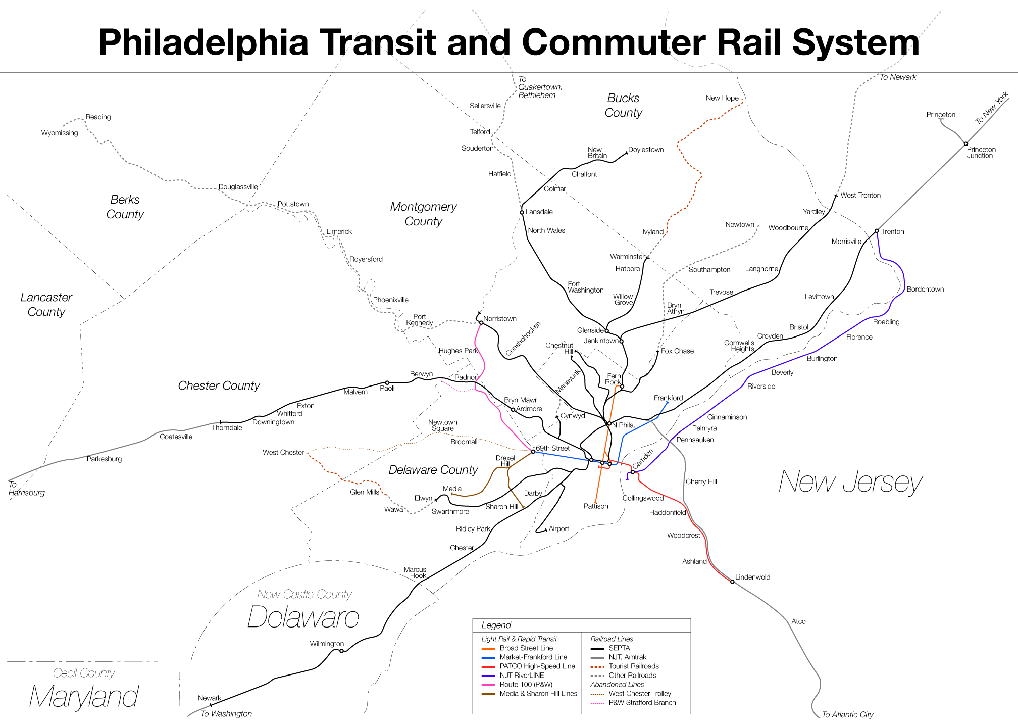
The Cynwyd Line is a SEPTA Regional Rail line from Center City, Philadelphia, Center City Philadelphia to Cynwyd (SEPTA station), Cynwyd in Montgomery County, Pennsylvania, Montgomery County, Pennsylvania. Originally known as the Ivy Ridge Line, service was truncated on May 17, 1986, at its current terminus at Cynwyd (SEPTA station), Cynwyd. Track between Cynwyd and Ivy Ridge (SEPTA station), Ivy Ridge was dismantled between 2008 and 2010 for conversion as an interim rail trail, preventing service restoration for the foreseeable future. The Cynwyd Line is the shortest of the SEPTA regional rail lines, and is the second-shortest regional rail line in the United States after New Jersey Transit, New Jersey Transit's Princeton Branch. It is by far the least ridden SEPTA Regional Rail Line. It is fully Grade separation, grade-separated. Route The Cynwyd Line runs from Suburban Station to the 52nd Street Junction, where it diverges from Amtrak's Philadelphia to Harrisburg Main Line, ... [...More Info...] [...Related Items...] OR: [Wikipedia] [Google] [Baidu] |
Lower Merion Township, Pennsylvania
Lower Merion Township is a Township (Pennsylvania), township in Montgomery County, Pennsylvania, United States. It is part of the Philadelphia Main Line. The township's name originates with the county of Merionethshire, Merioneth in north Wales. Merioneth is an English-language Orthographic transcription, transcription of the Welsh ''Meirionnydd''. A number of Main Line suburbs are located in Lower Merion, west of Philadelphia, the sixth largest city in the United States as of 2020. With a population of 63,633, Lower Merion Township is List of municipalities in Pennsylvania, the ninth-most populous municipality in Pennsylvania as of the 2020 United States census, 2020 U.S. census. The center of Lower Merion Township is located northwest of central Philadelphia, Pennsylvania's largest city-county, and parts of Lower Merion border this section of the city. History Lower Merion Township was first settled in 1682 by Welsh Quakers, who were granted a tract of land, the Welsh T ... [...More Info...] [...Related Items...] OR: [Wikipedia] [Google] [Baidu] |
Rail Trail
A rail trail or railway walk is a shared-use path on a Right of way#Rail right of way, railway right of way. Rail trails are typically constructed after a railway has been abandoned and the track has been removed but may also share the rail corridor with active railways, light rail, or tram, streetcars (rails with trails), or with disused track. As shared-use paths, rail trails are primarily for non-motorized traffic including pedestrians, bicycles, horseback riders, skaters, and cross-country skiers, although snowmobiles and all-terrain vehicle, ATVs may be allowed. The characteristics of abandoned railways—gentle grades, well-engineered rights of way and structures (bridges and tunnels), and passage through historical areas—lend themselves to rail trails and account for their popularity. Many rail trails are long-distance trails, while some shorter rail trails are known as Greenway (landscape), greenways or linear parks. Rail trails around the world Americas Bermuda The B ... [...More Info...] [...Related Items...] OR: [Wikipedia] [Google] [Baidu] |
Philadelphia Main Line
The Philadelphia Main Line, known simply as the Main Line, is an informally delineated historical and Social class in the United States, social region of suburban Philadelphia, Pennsylvania. Lying along the former Pennsylvania Railroad's once prestigious Main Line (Pennsylvania Railroad), Main Line, it runs northwest from Center City, Philadelphia, Center City Philadelphia parallel to Philadelphia and Lancaster Turnpike, also known as U.S. Route 30 in Pennsylvania, U.S. Route 30. The railroad first connected the Main Line towns in the 19th century. They became home to sprawling Estate (land)#United States, country estates belonging to Philadelphia's wealthiest families, and over the decades became a bastion of "old money". The Main Line includes some of the wealthiest communities in the country, including Gladwyne, Pennsylvania, Gladwyne, Villanova, Pennsylvania, Villanova, Radnor, Pennsylvania, Radnor, Haverford, Pennsylvania, Haverford, and Merion, Pennsylvania, Merion. Tod ... [...More Info...] [...Related Items...] OR: [Wikipedia] [Google] [Baidu] |
SEPTA
SEPTA, the Southeastern Pennsylvania Transportation Authority, is a regional public transportation authority that operates bus, rapid transit, commuter rail, light rail, and electric trolleybus services for nearly four million people throughout five counties in and around Philadelphia, Pennsylvania. It also manages projects that maintain, replace, and expand its infrastructure, facilities, and vehicles. SEPTA is the major transit provider for Philadelphia and four surrounding counties within the Philadelphia metropolitan area, including Delaware, Montgomery, Bucks, and Chester counties. It is a state-created authority, with the majority of its board appointed by the five counties it serves. Several SEPTA commuter rail and bus services serve New Castle County, Delaware and Mercer County, New Jersey, although service to Philadelphia from South Jersey is provided by the PATCO Speedline, which is run by the Delaware River Port Authority, a bi-state agency, and NJ Transit, w ... [...More Info...] [...Related Items...] OR: [Wikipedia] [Google] [Baidu] |
Cynwyd Station (SEPTA)
Cynwyd station is a SEPTA Regional Rail station in Bala Cynwyd, Pennsylvania. Located at Conshohocken State Road ( PA 23) and Bala Avenue, it is the last station along the Cynwyd Line. The station includes a 41-space parking lot. Service formerly continued farther northwest, crossing the Schuylkill River via the massive Manayunk Bridge, and ultimately terminating at Ivy Ridge station. This service ended in September 1986 when the integrity of the Manayunk Bridge was questioned. The massive span was shedding pieces of concrete due to spall Spall are fragments of a material that are broken off a larger solid body. It can be produced by a variety of mechanisms, including as a result of projectile impact, corrosion, weathering, cavitation, or excessive rolling pressure (as in a ba ...ing. Further investigation by Urban Engineers determined that the bridge was safe and only needed surface work to end the spalling. In 1999, construction finished on a project to stabilize and ... [...More Info...] [...Related Items...] OR: [Wikipedia] [Google] [Baidu] |
Philadelphia
Philadelphia ( ), colloquially referred to as Philly, is the List of municipalities in Pennsylvania, most populous city in the U.S. state of Pennsylvania and the List of United States cities by population, sixth-most populous city in the United States, with a population of 1,603,797 in the 2020 United States census, 2020 census. The city is the urban core of the Philadelphia metropolitan area (sometimes called the Delaware Valley), the nation's Metropolitan statistical area, seventh-largest metropolitan area and ninth-largest combined statistical area with 6.245 million residents and 7.379 million residents, respectively. Philadelphia was founded in 1682 by William Penn, an English Americans, English Quakers, Quaker and advocate of Freedom of religion, religious freedom, and served as the capital of the Colonial history of the United States, colonial era Province of Pennsylvania. It then played a historic and vital role during the American Revolution and American Revolutionary ... [...More Info...] [...Related Items...] OR: [Wikipedia] [Google] [Baidu] |
Manayunk Bridge
The Manayunk Bridge (also known as the Manayunk Viaduct, Pencoyd Viaduct, and Schuylkill River Railroad Bridge) is an S-shaped former railroad bridge over the Schuylkill River, Schuylkill Canal and Schuylkill Expressway, that connects Bala Cynwyd, Montgomery County and the Manayunk neighborhood of Philadelphia, Pennsylvania. Closed to rail traffic in 1986, it is now an extension of the Cynwyd Heritage Trail (along the river's west bank) and connects to the Schuylkill River Trail (along the east bank). History Built by the former Schuylkill Valley Division of the Pennsylvania Railroad, it is a large concrete open spandrel arch bridge built in an "S curve," earning both the current concrete bridge and its 1883 wrought-iron-truss predecessor the nickname of "S-Bridge." The bridge's challenging geometry was executed by T. L. Eyre, a Philadelphia contractor. Another notable feature is the saw-toothed construction joints along a 65-degree skew. In 1976, SEPTA purchased the b ... [...More Info...] [...Related Items...] OR: [Wikipedia] [Google] [Baidu] |
Schuylkill River
The Schuylkill River ( , ) is a river in eastern Pennsylvania. It flows for U.S. Geological Survey. National Hydrography Dataset high-resolution flowline dataThe National Map(). accessed April 1, 2011. from Pottsville, Pennsylvania, Pottsville southeast to Philadelphia, the nation's sixth-largest city, where it joins the Delaware River as one of its largest tributaries. The river's Drainage basin, watershed of about lies entirely within the state of Pennsylvania, stretching from the Ridge-and-Valley Appalachians through the Piedmont (United States), Piedmont to the Atlantic Plain. Historically the Schuylkill lay within the territory of the Susquehannock and Lenape peoples. In 1682, William Penn founded the city of Philadelphia between the Schuylkill and Delaware rivers on lands purchased from the Lenape Indian tribe. The Schuylkill River became key in the development of the city and the surrounding region. While long used for transport, the river was made fully navigable via ... [...More Info...] [...Related Items...] OR: [Wikipedia] [Google] [Baidu] |
Schuylkill River Trail
The Schuylkill River Trail ( , ) is a multi-use trail along the banks of the Schuylkill River in southeastern Pennsylvania. Partially complete, the trail is ultimately planned to run about from the river's headwaters in Schuylkill County, Pennsylvania, Schuylkill County to Fort Mifflin in Philadelphia. Completed portions of the trail include a section from Auburn, Pennsylvania, Auburn to Hamburg, Pennsylvania, Hamburg, a portion from Reading, Pennsylvania, Reading to Pottstown, Pennsylvania, Pottstown, and a portion from Oaks, Pennsylvania, Oaks to where Christian Street would meet the Schuylkill River, just South of Center City, Philadelphia, Center City Philadelphia and East of University of Pennsylvania. Large stretches of the trail are Rail trail, rail trails. Parts of it belong to the East Coast Greenway, a 3,000-mile trail system connecting Maine to Florida. On many maps and street atlases, and on some of the trail's signage, the segment between Philadelphia and Valle ... [...More Info...] [...Related Items...] OR: [Wikipedia] [Google] [Baidu] |
Manayunk, Philadelphia
Manayunk ( ) is a neighborhood in the section of Lower Northwest Philadelphia in the state of Pennsylvania. Located adjacent to the neighborhoods of Roxborough and Wissahickon and also on the banks of the Schuylkill River, Manayunk contains the first canal begun in the United States (although not the first completed, due to budget problems). The area's name is derived from the language of the Lenape Native American tribe. In 1686, in documents between William Penn and the Lenape, the Lenape referred to the Schuylkill River as "Manaiung", their word for "river", which literally translates as "place to drink"; the word was later altered and adopted as the town's name. Although historically a working class community, in recent years the neighborhood has been substantially gentrified. History Pre-industrial Manayunk Borough was originally a community in Roxborough Township, Philadelphia County, situated near the Schuylkill River, south of the Wissahickon Creek. The land that ... [...More Info...] [...Related Items...] OR: [Wikipedia] [Google] [Baidu] |
Rail Trails In Pennsylvania
Rail or rails may refer to: Rail transport *Rail transport and related matters *Railway track or railway lines, the running surface of a railway Arts and media Film * ''Rails'' (film), a 1929 Italian film by Mario Camerini * ''Rail'' (1967 film), a film by Geoffrey Jones for British Transport Films * ''Rail'' (2024 film), a Tamil-language film Magazines * ''Rail'' (magazine), a British rail transport periodical * ''Rails'' (magazine), a former New Zealand based rail transport periodical Other arts *The Rails, a British folk-rock band * Rail (theater) or batten, a pipe from which lighting, scenery, or curtains are hung Technology *Rails framework or Ruby on Rails, a web application framework *Rail system (firearms), a mounting system for firearm attachments *Front engine dragster *Runway alignment indicator lights, a configuration of an approach lighting system *Rule Augmented Interconnect Layout, a specification for expressing guidelines for printed circuit boards; companion ... [...More Info...] [...Related Items...] OR: [Wikipedia] [Google] [Baidu] |


