|
Cummings Island
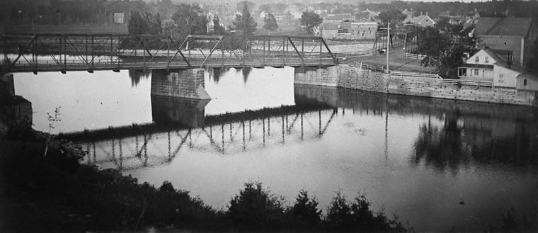
Cummings Island is an uninhabited island in the Rideau River in the city of Ottawa in Canada and the site of a former settlement. History The island's first settler was Charles Cummings, who built there his house in 1840 and operated a ferry across the Rideau River until a simple wooden bridge was built a few years later. Charles Cummings died in 1847 and was buried on the island. In 1864, Robert Cummings, son of Charles, bought the island from the government for $4 and built a store (with post office), flour mill and carriage factory there. During this period the island thrived as a commercial hub between Bytown Bytown is the former name of Ottawa, Ontario, Canada. It was founded on September 26, 1826, incorporated as a town on January 1, 1850, and superseded by the incorporation of the City of Ottawa on January 1, 1855. The founding was marked by a Grou ... and Janeville (later Eastview, and still later Vanier), even having the first telephone in what was then Gloucester ... [...More Info...] [...Related Items...] OR: [Wikipedia] [Google] [Baidu] |
Rideau River
The Rideau River (french: Rivière Rideau) is a river in Eastern Ontario, Canada. The river flows north from Upper Rideau Lake and empties into the Ottawa River at the Rideau Falls in Ottawa, Ontario. Its length is . As explained in a writing by Samuel de Champlain in 1613, the river was given the name "Rideau" (curtain) because of the appearance of the Rideau Falls. The Anishinàbemowin name for the river is "Pasapkedjinawong", meaning "the river that passes between the rocks." The Rideau Canal, which allows travel from Ottawa to the city of Kingston, Ontario on Lake Ontario, was formed by joining the Rideau River with the Cataraqui River. The river diverges from the Canal at Hog's Back Falls in Ottawa. In early spring, to reduce flooding on the lower section of the river, workers from the city of Ottawa use ice blasting to clear the ice which covers the river from Billings Bridge to Rideau Falls by cutting "keys" through the ice and using explosives to break off large ... [...More Info...] [...Related Items...] OR: [Wikipedia] [Google] [Baidu] |
Canada
Canada is a country in North America. Its ten provinces and three territories extend from the Atlantic Ocean to the Pacific Ocean and northward into the Arctic Ocean, covering over , making it the world's second-largest country by total area. Its southern and western border with the United States, stretching , is the world's longest binational land border. Canada's capital is Ottawa, and its three largest metropolitan areas are Toronto, Montreal, and Vancouver. Indigenous peoples have continuously inhabited what is now Canada for thousands of years. Beginning in the 16th century, British and French expeditions explored and later settled along the Atlantic coast. As a consequence of various armed conflicts, France ceded nearly all of its colonies in North America in 1763. In 1867, with the union of three British North American colonies through Confederation, Canada was formed as a federal dominion of four provinces. This began an accretion of provinces and ... [...More Info...] [...Related Items...] OR: [Wikipedia] [Google] [Baidu] |
Provinces And Territories Of Canada
Within the geographical areas of Canada, the ten provinces and three territories are sub-national administrative divisions under the jurisdiction of the Canadian Constitution. In the 1867 Canadian Confederation, three provinces of British North America—New Brunswick, Nova Scotia, and the Province of Canada (which upon Confederation was divided into Ontario and Quebec)—united to form a federation, becoming a fully independent country over the next century. Over its history, Canada's international borders have changed several times as it has added territories and provinces, making it the world's second-largest country by area. The major difference between a Canadian province and a territory is that provinces receive their power and authority from the '' Constitution Act, 1867'' (formerly called the '' British North America Act, 1867''), whereas territorial governments are creatures of statute with powers delegated to them by the Parliament of Canada. The powers flowing ... [...More Info...] [...Related Items...] OR: [Wikipedia] [Google] [Baidu] |
Ontario
Ontario ( ; ) is one of the thirteen provinces and territories of Canada.Ontario is located in the geographic eastern half of Canada, but it has historically and politically been considered to be part of Central Canada. Located in Central Canada, it is Canada's most populous province, with 38.3 percent of the country's population, and is the second-largest province by total area (after Quebec). Ontario is Canada's fourth-largest jurisdiction in total area when the territories of the Northwest Territories and Nunavut are included. It is home to the nation's capital city, Ottawa, and the nation's most populous city, Toronto, which is Ontario's provincial capital. Ontario is bordered by the province of Manitoba to the west, Hudson Bay and James Bay to the north, and Quebec to the east and northeast, and to the south by the U.S. states of (from west to east) Minnesota, Michigan, Ohio, Pennsylvania, and New York. Almost all of Ontario's border with the United States f ... [...More Info...] [...Related Items...] OR: [Wikipedia] [Google] [Baidu] |
Carleton County
Carleton County (2016 population 26,220) is located in west-central New Brunswick, Canada. The western border is Aroostook County, Maine, the northern border is Victoria County, and the southeastern border is York County from which it was formed in 1831. The Saint John River bisects the western section of the county. The Southwest Miramichi River flows through the eastern section of the county. Potato farming is a major industry. The scenic town of Hartland is home to the longest covered bridge in the world. Transportation Major Highways * * * * * * * * * * * * * * * * * * * * Census subdivisions Communities There are five incorporated municipalities within Carleton County (listed by 2016 population): First Nations There is one First Nations reserve in Carleton County, the Woodstock_First_Nation: Parishes The county is subdivided into eleven parishes (listed by 2016 population): Demographics As a census division in the 2021 Census of Population conducted by St ... [...More Info...] [...Related Items...] OR: [Wikipedia] [Google] [Baidu] |
Ottawa
Ottawa (, ; Canadian French: ) is the capital city of Canada. It is located at the confluence of the Ottawa River and the Rideau River in the southern portion of the province of Ontario. Ottawa borders Gatineau, Quebec, and forms the core of the Ottawa–Gatineau census metropolitan area (CMA) and the National Capital Region (NCR). Ottawa had a city population of 1,017,449 and a metropolitan population of 1,488,307, making it the fourth-largest city and fourth-largest metropolitan area in Canada. Ottawa is the political centre of Canada and headquarters to the federal government. The city houses numerous foreign embassies, key buildings, organizations, and institutions of Canada's government, including the Parliament of Canada, the Supreme Court, the residence of Canada's viceroy, and Office of the Prime Minister. Founded in 1826 as Bytown, and incorporated as Ottawa in 1855, its original boundaries were expanded through numerous annexations and were ultimately ... [...More Info...] [...Related Items...] OR: [Wikipedia] [Google] [Baidu] |
Robert Cummings (politician)
Robert Cummings (June 16, 1833 – January 16, 1910) at the Beechwood Cemetery, Carleton County, Ontario. was a Canadians, Canadian manufacturer and community leader. He was born in Gloucester Township, Ontario to a family of Ireland, Irish immigrants in 1833. He learned the trade of carriage making and became a leading Canadian manufacturer. He opened a general store and operated a flour mill on Cummings Island in the Rideau River which became the nucleus of a new community, Janeville, which eventually became part of Vanier, Ontario, Vanier. He served ten years as reeve in the township, was also a Justice of the Peace and was elected warden for Carleton County, Ontario, Carleton County in 1876. Cummings was also a captain in the local militia. He married Agnes Borthwick (1840–1921). The Cummings Bridge a ... [...More Info...] [...Related Items...] OR: [Wikipedia] [Google] [Baidu] |
Bytown
Bytown is the former name of Ottawa, Ontario, Canada. It was founded on September 26, 1826, incorporated as a town on January 1, 1850, and superseded by the incorporation of the City of Ottawa on January 1, 1855. The founding was marked by a sod turning, and a letter from Governor General Dalhousie which authorized Lieutenant Colonel John By to divide up the town into lots. Bytown came about as a result of the construction of the Rideau Canal and grew largely due to the Ottawa River timber trade. Bytown's first mayor was John Scott, elected in 1847. Overview Bytown was located where the Rideau Canal meets the Ottawa River and consisted of two parts centered around the canal, Upper Town and Lower Town. Upper Town, situated to the west of the canal, was situated in the area of the current downtown and Parliament Hill. Lower Town was on the east side of the canal where today's Byward Market and general area of Lower Town still exists. The two areas of town were connected ove ... [...More Info...] [...Related Items...] OR: [Wikipedia] [Google] [Baidu] |
Vanier, Ontario
Vanier, formerly Eastview, is a neighbourhood in the Rideau-Vanier Ward of Ottawa, Ontario, Canada's east end. Historically francophone and working class, the neighbourhood was a separate city until being amalgamated into Ottawa in 2001. It no longer has a majority francophone population. By 2012 its francophone population had shrunk to less than 40% from 63% in the early 1980s. The neighbourhood is located on the east bank of the Rideau River, across from the neighbourhoods of Lowertown and Sandy Hill, and just south of Rockcliffe Park, New Edinburgh, Lindenlea, and Manor Park. To the east of Vanier are the suburbs of Gloucester. Vanier has a relatively small area with a high population density. History In 1908, the communities of Janeville, Clarkstown and Clandeboye were joined to form the village of Eastview. In 1913, Eastview was incorporated as a town. Originally it was a popular destination for civil servants who wished to live at a distance from downtown. It later sa ... [...More Info...] [...Related Items...] OR: [Wikipedia] [Google] [Baidu] |
Gloucester Township, Ontario
Gloucester ( ) is a former municipality and now geographic area of Ottawa, Ontario, Canada. Located east of Ottawa's inner core, it was an independent city until amalgamated with the Regional Municipality of Ottawa–Carleton in 2001 to become the new city of Ottawa. The population of Gloucester is about 150,012 people (2021 Census). History Gloucester, originally known as Township B, was established in 1792. The first settler in the township was Braddish Billings in what is now the Billings Bridge area of Ottawa. In 1800, the township became part of Russell County, and later Carleton County in 1838. In 1850, the area was incorporated as Gloucester Township, named after Prince William Frederick, Duke of Gloucester and Edinburgh. Over the years, parts of Gloucester Township were annexed by the expanding city of Ottawa. Gloucester was incorporated as a city in 1981 and became part of the amalgamated city of Ottawa in 2001. Town Halls 1872—1962: Bank Street in Billings B ... [...More Info...] [...Related Items...] OR: [Wikipedia] [Google] [Baidu] |
Samuel Bingham
Samuel "Sam" Bingham (184516 June 1905) was the Mayor of Ottawa, Ontario, Canada between 1897 and 1898.Dave Mullington "Chain of Office: Biographic Sketches of Ottawa's Mayors (1847-1948)" (Renfrew, Ontario: General Store Publishing House, 2005) He was born in Bytown's Lower Town to Irish Catholic parents in 1845. As a young man, he worked on the log drives on the Gatineau River. With the Gilmour and Edwards lumber companies, he formed the Gatineau Boom Company, which later became part of the Canadian International Paper Company. He was an alderman on the Ottawa City Council from 1880 to 1893. Bingham believed that English speaking citizens of Ottawa should learn French. In 1905, he drowned in the Gatineau River near Wakefield, Quebec after he fell asleep while returning in a horse-drawn wagon from clearing a log jam on the river. There is a bust of Bingham by sculptor Hamilton MacCarthy in Notre-Dame Cemetery. In 1893, an attempt to rename the Cummings Bridge over the Rideau ... [...More Info...] [...Related Items...] OR: [Wikipedia] [Google] [Baidu] |
Cummings Bridge
The Cummings Bridge in Ottawa, Ontario, Canada, crosses the Rideau River, connecting Rideau Street to Montreal Road in Vanier. It is a multi-span open spandrel arch bridge, constructed in 1921 and renovated in 1996. History The area east of the Cummings Bridge, later named Vanier was first linked to the Sandy Hill area of Ottawa with a wooden bridge erected in 1835, which went over Cummings Island in the Rideau River. The Cummings family settled the island, had a store there, and the island and bridge there became associated with the Cummings name. In 1891, the old wooden bridge was replaced by a steel bridge, which the city wanted to name Bingham's Bridge, after Ottawa mayor Samuel Bingham, but this name never caught on. The current bridge was constructed in 1921, some downstream from the steel bridge, bypassing Cummings Island. Charles Cummings had a son, Robert Cummings who became Reeve of Gloucester Township and Warden of Carleton County, Ontario Carleton County is ... [...More Info...] [...Related Items...] OR: [Wikipedia] [Google] [Baidu] |


