|
Cultural Triangle Yaxha-Nakum-Naranjo National Park
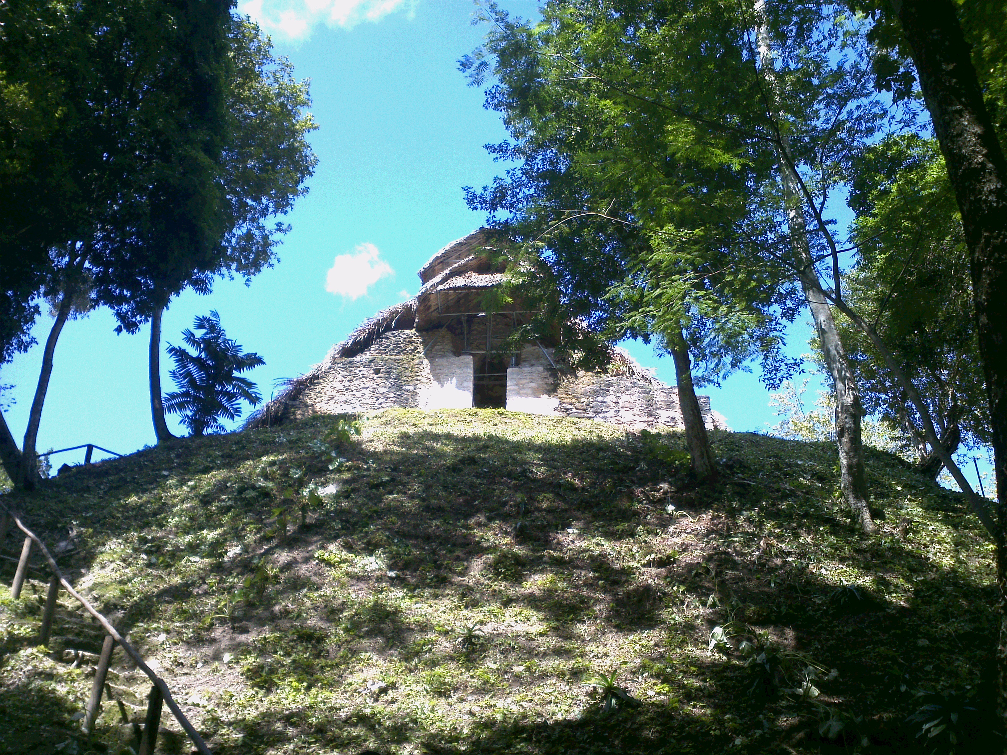
The Cultural Triangle Yaxha-Nakum-Naranjo National Park (Triángulo Cultural in Spanish) is a multidisciplinary project involving archaeologists, architects, restaurateurs, and biologists. It is situated in Petén, Guatemala. The project does not only work in one archaeological site, but in a region of including three gigantic sites and 14 sub-centers – the most populated area of the Classic period of the Maya civilization. History The project, founded in 1994, started with over 300 Guatemalan workers and 12 scientists. The first work carried out was at Topoxte, an island within the lake of Yaxha. Here you find the only exposed architecture of the Maya Postclassic period in the whole Petén Basin. One of the temples, so called Temple C, was near to its collapse. That’s why the team restored it during the first two years. Today the island is one of the principal points of interest in the Petén and the cooperative of the project brings many tourists by boat to the island. Y ... [...More Info...] [...Related Items...] OR: [Wikipedia] [Google] [Baidu] |
Guatemala
Guatemala, officially the Republic of Guatemala, is a country in Central America. It is bordered to the north and west by Mexico, to the northeast by Belize, to the east by Honduras, and to the southeast by El Salvador. It is hydrologically bordered to the south by the Pacific Ocean and to the northeast by the Gulf of Honduras. The territory of modern Guatemala hosted the core of the Maya civilization, which extended across Mesoamerica; in the 16th century, most of this was Spanish conquest of Guatemala, conquered by the Spanish and claimed as part of the viceroyalty of New Spain. Guatemala attained independence from Spain and Mexico in 1821. From 1823 to 1841, it was part of the Federal Republic of Central America. For the latter half of the 19th century, Guatemala suffered instability and civil strife. From the early 20th century, it was ruled by a series of dictators backed by the United States. In 1944, authoritarian leader Jorge Ubico was overthrown by a pro-democratic m ... [...More Info...] [...Related Items...] OR: [Wikipedia] [Google] [Baidu] |
Tikal
Tikal (; ''Tik'al'' in modern Mayan orthography) is the ruin of an ancient city, which was likely to have been called Yax Mutal, found in a rainforest in Guatemala. It is one of the largest archaeological sites and urban centers of the Pre-Columbian era, pre-Columbian Maya civilization. It is located in the archaeological region of the Petén Basin in what is now northern Guatemala. Situated in Petén Department, the site is part of Guatemala's Tikal National Park and in 1979 it was declared a UNESCO World Heritage Site. Tikal was the capital of a state that became one of the most powerful kingdoms of the ancient Maya. Though monumental architecture at the site dates back as far as the 4th century BC, Tikal reached its apogee during the Mesoamerican chronology, Classic Period, c. 200 to 900. During this time, the Maya city, city dominated much of the Maya region politically, economically, and militarily, while interacting with areas throughout Mesoamerica such as the great metr ... [...More Info...] [...Related Items...] OR: [Wikipedia] [Google] [Baidu] |
Petén Department
Petén (from the Itza' language, Itz'a, , 'Great Island') is a Departments of Guatemala, department of Guatemala. It is geographically the northernmost department of Guatemala, as well as the largest by area at it accounts for about one third of Guatemala's area. The capital is Flores, Guatemala, Flores. The population at the mid-2018 official estimate was 595,548.Instituto Nacional de Estadistica Guatemala (web). Geography The Petén department is bordered on the east by Belize and by Mexico (with the Mexican states of Chiapas to the west, Tabasco to the northwest and Campeche to the north). Its northwest border includes the border town of El Ceibo, Guatemala, adjacent to El Ceibo, Tabasco, Mexico. To the south it borders the Guatemalan departments of Alta Verapaz and Izabal Department, Izabal.ITMB Publishing Ltd. 2005. Much of the western border with Mexico is formed by the Usumacinta River and its tributary the Salinas River (Guatemala), Salinas River. Portions of the souther ... [...More Info...] [...Related Items...] OR: [Wikipedia] [Google] [Baidu] |
1994 Establishments In Guatemala
The year 1994 was designated as the "International Year of the Family" and the "International Year of Sport and the Olympic Charter, Olympic Ideal" by the United Nations. In the Line Islands and Phoenix Islands of Kiribati, 1994 had only 364 days, omitting December 31. This was due to an adjustment of the International Date Line by the Kiribati government to bring all of its territories into the same calendar day. Events January * January 1 ** The North American Free Trade Agreement (NAFTA) is established. ** Beginning of the Zapatista uprising in Mexico. * January 8 – ''Soyuz TM-18'': Valeri Polyakov begins his 437.7-day orbit of the Earth, eventually setting the world record for days spent in orbit. * January 11 – The Irish government announces the end of a 15-year broadcasting ban on the Provisional Irish Republican Army and its political arm Sinn Féin. * January 14 – U.S. President Bill Clinton and Russian President Boris Yeltsin sign the Kremlin accords, which ... [...More Info...] [...Related Items...] OR: [Wikipedia] [Google] [Baidu] |
Archaeological Sites In Guatemala
Archaeology or archeology is the study of human activity through the recovery and analysis of material culture. The archaeological record consists of Artifact (archaeology), artifacts, architecture, biofact (archaeology), biofacts or ecofacts, archaeological site, sites, and cultural landscapes. Archaeology can be considered both a social science and a branch of the humanities. It is usually considered an independent academic discipline, but may also be classified as part of anthropology (in North America – the four-field approach), history or geography. The discipline involves Survey (archaeology), surveying, Archaeological excavation, excavation, and eventually Post excavation, analysis of data collected, to learn more about the past. In broad scope, archaeology relies on cross-disciplinary research. Archaeologists study human prehistory and history, from the development of the first stone tools at Lomekwi in East Africa 3.3 million years ago up until recent decades. A ... [...More Info...] [...Related Items...] OR: [Wikipedia] [Google] [Baidu] |
Maya Sites In Petén Department
Maya may refer to: Ethnic groups * Maya peoples, of southern Mexico and northern Central America ** Maya civilization, the historical civilization of the Maya peoples ** Mayan languages, the languages of the Maya peoples * Maya (East Africa), a population native to the old Wej province in Ethiopia * Sibuyanon, a Visayan population sometimes "May-" native to Sibuyan Island in the Philippines Religion and mythology * Maya (religion), in Indian religions, relates to the illusion of reality *Maya (mother of the Buddha) (died 563 BC), mother of the historical Buddha *Mayasura or Maya, a Hindu demon * Maya religion, the religious practices of the Maya peoples of parts of Mexico and Central America ** Maya mythology, the myths and legends of the Maya civilization People * Maya (given name), a feminine name (including a list of people and fictional characters with the name) Places * Maya (Aldan), a river in Yakutia and the north of Khabarovsk Krai, Russia * Maya (Uda), a river in Am ... [...More Info...] [...Related Items...] OR: [Wikipedia] [Google] [Baidu] |
National Parks Of Guatemala
National may refer to: Common uses * Nation or country ** Nationality – a ''national'' is a person who is subject to a nation, regardless of whether the person has full rights as a citizen Places in the United States * National, Maryland, census-designated place * National, Nevada, ghost town * National, Utah, ghost town * National, West Virginia, unincorporated community Commerce * National (brand), a brand name of electronic goods from Panasonic * National Benzole (or simply known as National), former petrol station chain in the UK, merged with BP * National Book Store, a bookstore and office supplies chain in the Philippines * National Car Rental, an American rental car company * National Energy Systems, a former name of Eco Marine Power * National Entertainment Commission, a former name of the Media Rating Council * National Motor Vehicle Company, Indianapolis, Indiana, USA 1900–1924 * National Radio Company, Malden, Massachusetts, USA 1914–1991 * National Supermarket ... [...More Info...] [...Related Items...] OR: [Wikipedia] [Google] [Baidu] |
Naranjo
Naranjo (Wak Kab'nal in Mayan) is a Pre-Columbian Maya city in the Petén Basin region of Guatemala. It was occupied from about 500 BC to 950 AD, with its height in the Late Classic Period. The site is part of Yaxha-Nakum-Naranjo National Park. The city lies along the Mopan and Holmul rivers, and is about 50 km east of the site of Tikal. Naranjo has been the victim of severe looting. The site is known for its polychrome ceramic style. "Naranjo" in Spanish means "orange tree", which is a Spanish translation of the Mayan name Wak Kab'nal. The emblem glyph of the Naranjo is transliterated as Sa'aal “the place where (maize) gruel abounds.” The Naranjo dynastic rulers are said to be the "Holy Lords of Sa'aal." Layout of site The area of Naranjo covers at least 8 km2 with the urban center covering about 2.25 km2. There are currently 389 recorded buildings in the central area and over 900 around the center. The epicenter consists of six triadic complexes, two b ... [...More Info...] [...Related Items...] OR: [Wikipedia] [Google] [Baidu] |
Nakum
Nakum ("House of the pot") is a Mesoamerican archaeological site, and a former ceremonial center and city of the pre-Columbian Maya civilization. It is located in the northeastern portion of the Petén Basin region, in the modern-day Guatemalan department of Petén. The northeastern Petén region contains a good number of other significant Maya sites, and Nakum is one of the three sites forming the Cultural Triangle of " Yaxha-Nakum- Naranjo". Nakum is approximately to the north of Yaxha and some to the east of Tikal, on the banks of the Holmul River. Its main features include an abundance of visibly restored architecture, and the roof comb of the site's main temple structure is one of the best-preserved outside Tikal. History This city has evidence of occupation dating from the Middle Preclassic period of Mesoamerican chronology. For the most part of the Classic period, Nakum appeared to be subordinate to Tikal. Nakum particularly flourished during the Late Classic (c. ... [...More Info...] [...Related Items...] OR: [Wikipedia] [Google] [Baidu] |
Petén (department)
Petén or Peten may refer to: *Petén Department, a department of Guatemala *Petén Basin The Petén Basin is a geographical subregion of the Maya Lowlands, primarily located in northern Guatemala within the Department of El Petén, and into the state of Campeche in southeastern Mexico. During the Late Preclassic and Classic periods ..., the geographical/archaeological region of Mesoamerica and a center of the Maya civilization * Lake Petén Itzá, a lake in the Petén Basin region * Peten Itza kingdom, a Maya kingdom in Central America centered on the city of Nojpetén *The Hebrew name () for the Boeing AH-64A Apache in Israeli service, meaning "Cobra" in English * Petén molly, a fish {{disambiguation, geo ... [...More Info...] [...Related Items...] OR: [Wikipedia] [Google] [Baidu] |
Petén Basin
The Petén Basin is a geographical subregion of the Maya Lowlands, primarily located in northern Guatemala within the Department of El Petén, and into the state of Campeche in southeastern Mexico. During the Late Preclassic and Classic periods of pre-Columbian Mesoamerican chronology many major centers of the Maya civilization flourished, such as Tikal and Calakmul. A distinctive Petén-style of Maya architecture and inscriptions arose. The archaeological sites La Sufricaya and Holmul are also located in this region. History By the first half of the 1st millennium BCE, the Petén and Mirador Basin of this region were already well-established with a number of monumental sites and cities of the Maya civilization. Significant Maya sites of this Preclassic era of Mesoamerican chronology include Nakbé, El Mirador, Naachtun, San Bartolo and Cival in the Mirador Basin. Classic Period Later, Petén became the heartland of the Maya Classic Period (c. 200 – 900 CE). ... [...More Info...] [...Related Items...] OR: [Wikipedia] [Google] [Baidu] |
Yaxha
Yaxha (or Yaxhá in Spanish orthography) is a Mesoamerican archaeological site in the northeast of the Petén Basin in modern-day Guatemala. As a ceremonial centre of the pre-Columbian Maya civilization, Yaxha was the third largest city in the region and experienced its maximum power during the Early Classic period (c. AD 250–600). The city was located on a ridge overlooking Lake Yaxha. The name of the city derives from the Mayan for "blue-green water"; it is a notable survival of a Classic period place-name into the modern day. The Yaxha kingdom is estimated to have covered an area of and to have had a peak population of 42,000 in the Late Classic period of Mesoamerican chronology. Yaxha had a long history of occupation with the first settlement being founded sometime in the Middle Preclassic period (c. 1000–350 BC). It developed into the largest city in the eastern Petén lakes region during the Late Preclassic (c. 350 BC – AD 250) and expanded into an enormous city durin ... [...More Info...] [...Related Items...] OR: [Wikipedia] [Google] [Baidu] |


