|
Cow Neck Peninsula
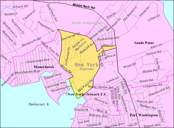
The Cow Neck Peninsula is a peninsula in Nassau County, New York, on the North Shore of Long Island. Description The Cow Neck Peninsula was named Cow Neck in the 17th Century, in large part due to the fact that it served as a common pasture at the time. The Cow Neck Peninsula is famous for its affluence and historic communities, and was famous for its sand mines along Hempstead Harbor throughout the 20th Century. It is believed that 90% of the concrete that built the foundations of New York City came from the Port Washington sand mines, and that over 100 million tons of sand were shipped to Manhattan. The Cow Neck Peninsula is also known as Manhasset Neck or simply as Cow Neck. Geography On its west side, the Cow Neck Peninsula is bordered by Manhasset Bay. On its east side, it is bordered by Hempstead Harbor. To the north, it is bordered by the Long Island Sound. Some places on the Cow Neck Peninsula – notably in Flower Hill and Manhasset – reach elevations high ... [...More Info...] [...Related Items...] OR: [Wikipedia] [Google] [Baidu] |
Nassau County, New York
Nassau County ( ) is a County (United States), county in the U.S. state of New York (state), New York. At the 2020 United States Census, 2020 U.S. census, Nassau County's population is 1,395,774. The county seat is Mineola, New York, Mineola and the largest town is Hempstead, New York, Hempstead. Nassau County is situated on western Long Island, bordering New York City's Boroughs of New York City, borough of Queens to the west, and Suffolk County, New York, Suffolk County to the east. It is the most densely populated and second-most populous county in the State of New York outside of New York City, with which it maintains extensive commuter rail, rail and highway connectivity, and is considered one of the central counties within the New York metropolitan area. Nassau County contains two Administrative divisions of New York (state)#City, cities, three Political subdivisions of New York State#Town, towns, 64 incorporated Political subdivisions of New York State#Village, village ... [...More Info...] [...Related Items...] OR: [Wikipedia] [Google] [Baidu] |
Manhasset Bay
Manhasset Bay, New York, is an embayment in western Long Island off Long Island Sound. Description Manhasset Bay forms the northeastern boundary of the Great Neck Peninsula and the southwestern boundary of Cow Neck (Port Washington Peninsula or Manhasset Neck). On the north side of the bay there are three points, Barkers Point at the entrance, Plum Point coming the furthest into the Bay, and Tom's Point in the back bay. On the other side, Hewlett Point forms the entrance nearly a mile from Barkers Point. Hart Island lies in the Sound just outside the mouth of Manhasset Bay. The Manhasset Bay area was likely first inhabited in the 17th century by the Matinecook tribe of Algonquin Indians. However, that view has been challenged. Then the Dutch and the English settled around the bay in the 17th century because of the proximity of fish. The Bay was called Schout's Bay by the Dutch, and then Howe's Bay by the English. Subsequently, due to the presence of cattle raising, it ... [...More Info...] [...Related Items...] OR: [Wikipedia] [Google] [Baidu] |
Sands Point, New York
Sands Point is a village located at the tip of the Cow Neck Peninsula in the Town of North Hempstead, in Nassau County, on the North Shore of Long Island, in New York, United States. It is considered part of the Greater Port Washington area, which is anchored by Port Washington. The population was 2,675 at the 2010 census. History The village was incorporated in 1910, and is named for the Sands family. In 1912, the village absorbed the communities of Barkers Point and Motts Point, and in 1932, it absorbed the Harbor Acreas community. It was originally owned by three families: the Sands, the Vanderbilts, and the Cornwells. In 1917, Daniel Guggenheim bought his Hempstead House, formerly Castle Gould. His son Harry Guggenheim, founder of ''Newsday'', later erected his estate "Falaise" nearby in 1923. Today, the estate belongs to the Friends of the Sands Point Preserve, which is a non-profit organization that maintains the property. In the 1960s, under less strict building ... [...More Info...] [...Related Items...] OR: [Wikipedia] [Google] [Baidu] |
Port Washington North, New York
Port Washington North is a Village (New York), village in Nassau County, New York, Nassau County, on the North Shore (Long Island), North Shore of Long Island, in New York (state), New York, United States. It is considered part of the Greater Port Washington area, which is anchored by Port Washington, New York, Port Washington. The population was 3,154 at the 2010 census. The Incorporated Village of Port Washington North is located on the Cow Neck Peninsula, within the North Hempstead, New York, Town of North Hempstead. History Port Washington North incorporated in 1932 after residents of the area unanimously voted in favor of incorporating on July 6 of that year. Its first Mayor, John Cocks, led the movement to incorporate; he was elected on August 2, 1932. In 1931, one year prior to Port Washington North incorporating itself as a village, the adjacent village, Manorhaven, New York, Manorhaven, unsuccessfully attempted to annex the area. Manorhaven was unsuccessful due to the f ... [...More Info...] [...Related Items...] OR: [Wikipedia] [Google] [Baidu] |
Plandome Manor, New York
Plandome Manor is a village in Nassau County, on the North Shore of Long Island, in New York, United States. The majority of the village is considered part of the Greater Manhasset area, which is anchored by Manhasset. The easternmost part of the village is more closely associated with Port Washington. The population was 872 at the 2010 census. The Incorporated Village of Plandome Manor is in the Town of North Hempstead, and is the northernmost of the three Plandomes. History The Village of Plandome Manor incorporated in 1931. Like the villages of Plandome and Plandome Heights to its south, Plandome Manor derives its name from the Latin 'Planus Domus', meaning plain, or level home. The manor house of Matthias Nicoll who was an early mayor of New York City and among the first generation of the Nicoll family on Long Island, was a wood-frame home built in the 1670s, and one of the first homesteads in this area of Cow Neck, the namesake of the Cow Neck Peninsula (also known as t ... [...More Info...] [...Related Items...] OR: [Wikipedia] [Google] [Baidu] |
Plandome Heights, New York
Plandome Heights is a village in Nassau County, on the North Shore of Long Island, in New York, United States. It is considered part of the Greater Manhasset area, which is anchored by Manhasset. The population was 1,005 at the 2010 census. The Incorporated Village of Plandome Heights is located entirely within the Town of North Hempstead and is the southernmost of the three Plandomes. History In the early 20th century, Benjamin N. Duke of the Duke tobacco family developed large parts of what is now Plandome Heights through the Plandome Heights Company, which was one of Duke's real estate ventures; many of these homes were built in the Spanish style, which was a popular architectural style at the time. The Duke family owned large portions of Plandome Heights in the early 20th century. Prior to incorporating, the residents in the original part of Plandome Heights (the western and central portions) had unsuccessfully petitioned for neighboring Plandome to annex their area. Thi ... [...More Info...] [...Related Items...] OR: [Wikipedia] [Google] [Baidu] |
Plandome, New York
Plandome is a village in the Town of North Hempstead in Nassau County, on the North Shore of Long Island, in New York, United States. It is considered part of the Greater Manhasset area, which is anchored by Manhasset. The population was 1,349 at the 2010 census. The Incorporated Village of Plandome was ranked fifth on Forbes' 10 most affluent U.S. communities list in 2009. History The Great Neck and Port Washington Railroad, a subsidiary of the Long Island Rail Road, built what is today known as the Port Washington Branch through the community in 1898; Plandome became a flag stop until it received a station in 1909. The original station building suffered a serious fire in January 1987, and was rebuilt along with platform lengthening and refurbishment by 1990. The Village of Plandome was incorporated in 1911 as the Plandome Land Company began to develop the village itself, though some homes, farmhouses, and mills had been built in the area in prior decades. Plandome, l ... [...More Info...] [...Related Items...] OR: [Wikipedia] [Google] [Baidu] |
Manorhaven, New York
Manorhaven is a village in Nassau County, on the North Shore of Long Island, in New York, United States. It is considered part of the Greater Port Washington area, which is anchored by Port Washington. The population was 6,556 at the 2010 census. The Incorporated Village of Manorhaven is located on the Cow Neck Peninsula, within the Town of North Hempstead. History Manorhaven was incorporated in 1930, after news was spread that Port Washington was planning on incorporating itself as a city. The name of the village was selected by locals, who felt that it reflected the feel and nature of the area. Geography According to the United States Census Bureau, the village has a total area of , of which is land and , or 25.40%, is water. Manorhaven is located within the Manhasset Bay Watershed, and is located within the larger Long Island Sound/Atlantic Ocean Watershed. According to the United States Environmental Protection Agency and the United States Geological Survey, the ... [...More Info...] [...Related Items...] OR: [Wikipedia] [Google] [Baidu] |
Baxter Estates, New York
Baxter Estates is a village in Nassau County, on the North Shore of Long Island, in New York, United States. It is considered part of the Greater Port Washington area, which is anchored by Port Washington. The population was 999 at the 2010 census. The Incorporated Village of Baxter Estates is located on the Cow Neck Peninsula, within the Town of North Hempstead, and is recognized as a Tree City USA. History The Village of Baxter Estates was incorporated in 1931. Baxter Estates owes much of its history to the homestead settlement of "Cow Neck" built in 1673 by John Betts and Robert Hutchings, which still stands on its original site at the corner of Central Drive and Shore Road, overlooking Manhasset Bay. This property was purchased around 1741 by Oliver Baxter, and maps of the time show that an entire wigwam village, belonging to the Matinecock Indians, may have been located on Baxter's land. The Baxters, who were shipbuilders, whalers and sea captains, retained the prope ... [...More Info...] [...Related Items...] OR: [Wikipedia] [Google] [Baidu] |
1873 Beers Map Of North Hempstead, Great Neck, And Roslyn, Long Island, New York - Geographicus - NorthHempstead-beers-1873
Events January–March * January 1 ** Japan adopts the Gregorian calendar. ** The California Penal Code goes into effect. * January 17 – American Indian Wars: Modoc War: First Battle of the Stronghold – Modoc Indians defeat the United States Army. * February 11 – The Spanish Cortes deposes King Amadeus I, and proclaims the First Spanish Republic. * February 12 ** Emilio Castelar, the former foreign minister, becomes prime minister of the new Spanish Republic. ** The Coinage Act of 1873 in the United States is signed into law by President Ulysses S. Grant; coming into effect on April 1, it ends bimetallism in the U.S., and places the country on the gold standard. * February 20 ** The University of California opens its first medical school in San Francisco. ** British naval officer John Moresby discovers the site of Port Moresby, and claims the land for Britain. * March 3 – Censorship: The United States Congress enacts the Comstock Law, making i ... [...More Info...] [...Related Items...] OR: [Wikipedia] [Google] [Baidu] |
Skyline Of New York City
New York City, the most populous city in the United States, is home to over 7,000 completed high-rise buildings of at least , of which at least 95 are taller than . The tallest building in New York is One World Trade Center, which rises . The 104-story skyscraper also stands as the tallest building in the United States, the tallest building in the Western Hemisphere, and the seventh-tallest building in the world. At , Central Park Tower is the second-tallest completed building in the city. It has the highest roof of any building outside Asia, and is the tallest residential building in the world. The third-tallest completed building in the city is 111 West 57th Street. Rising to , it is the world's most slender skyscraper. The fourth-tallest is One Vanderbilt. At , it is the tallest office building in Midtown. The fifth-tallest is 432 Park Avenue at . At , the 102-story Empire State Building in Midtown Manhattan, which was finished in 1931, stood as the tallest buil ... [...More Info...] [...Related Items...] OR: [Wikipedia] [Google] [Baidu] |
Manhasset, New York
Manhasset is a hamlet and census-designated place (CDP) in Nassau County, on the North Shore of Long Island, in New York. It is considered the anchor community of the Greater Manhasset area. The population was 8,176 at the 2020 United States census. As with other unincorporated communities in New York, its local affairs are administered by the town in which it is located, the Town of North Hempstead, whose town hall is in Manhasset, making the hamlet the town seat. Etymology The name Manhasset was adopted in 1840. It is most likely the anglicized rendition of the name of a local Native American tribe whose name translates to "the island neighborhood". History The Matinecock had a village on Manhasset Bay. These Native Americans called the area Sint Sink, meaning "place of small stones". They made wampum from oyster shells. In 1623, the area was claimed by the Dutch West India Company and they began forcing English settlers to leave in 1640. A 1643 land purchase made it poss ... [...More Info...] [...Related Items...] OR: [Wikipedia] [Google] [Baidu] |


