|
City West Link
City West Link is a link road connecting Parramatta Road and the Western Distributor through the Inner West suburbs of Sydney, New South Wales, Australia. It was bypassed by the WestConnex project upon its completion in November 2023. This name covers a few consecutive roads and is widely known to most drivers, but the entire allocation is also known – and signposted – by the names of its constituent parts: Wattle Street, Dobroyd Parade, City West Link proper and The Cresent. Route City West Link starts at the intersection of Parramatta Road and Frederick Street in Haberfield as Wattle Street and heads in an easterly direction as a six-lane, dual-carriageway road, where after a short distance it meets the intersection with Ramsay Road (on the surface), and the ramps for the M4 Motorway (underground, westbound for M4 East and eastbound for M4-M8 Link). At the intersection with Waratah Street it changes name to Dobroyd Parade and narrows to a four-lane, single carriageway, ... [...More Info...] [...Related Items...] OR: [Wikipedia] [Google] [Baidu] |
Lilyfield Light Rail Station
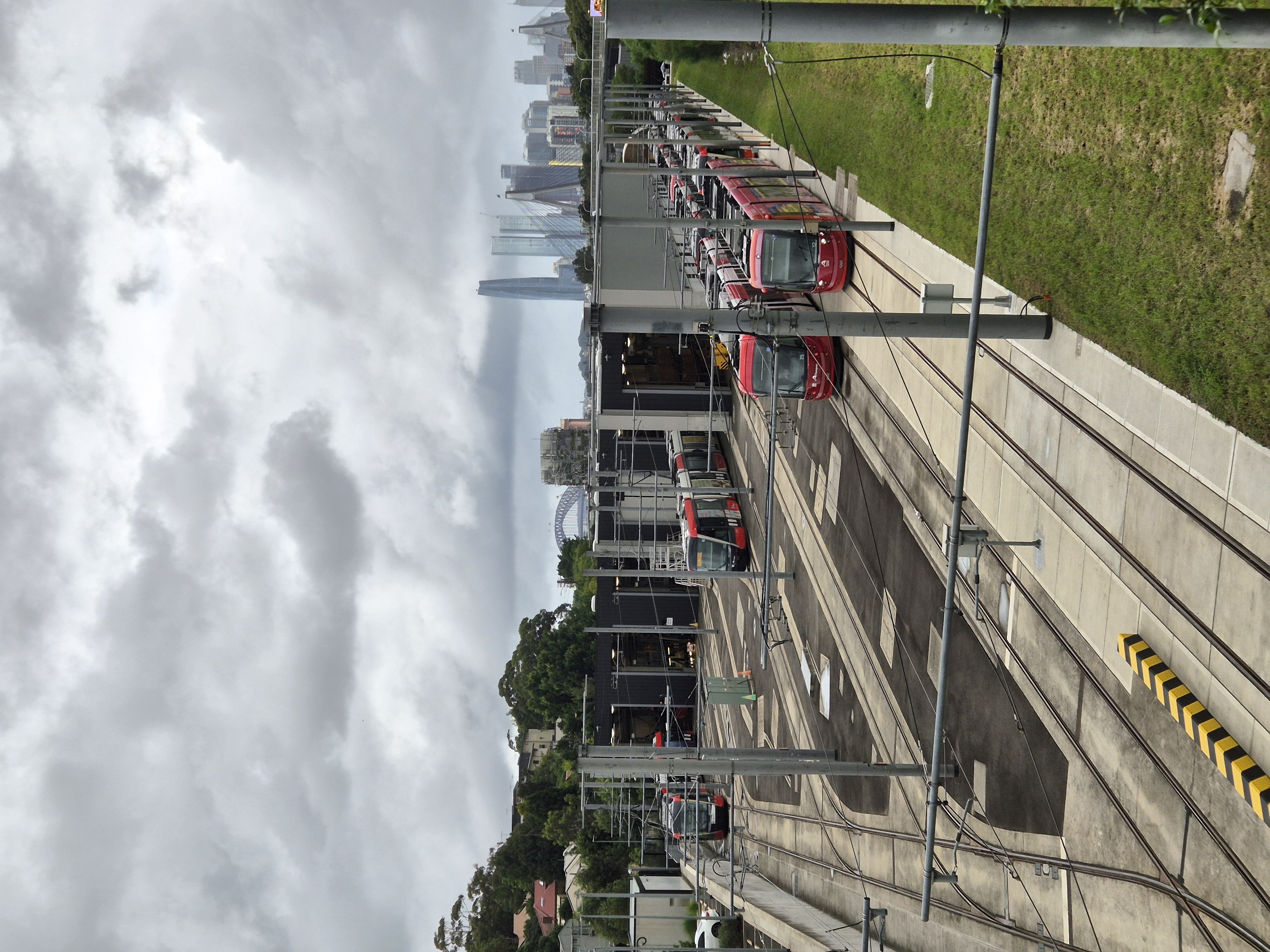
Lilyfield light rail station is a light rail station located on the Inner West Light Rail line, serving the Sydney suburb of Lilyfield. It is served by Sydney Light Rail L1 Dulwich Hill Line services. The stop opened on 13 August 2000 with the line's extension, becoming its terminus until 2014. The station is located at the edge of a wide cutting, beneath the City West Link road which passes overhead. Lilyfield Maintenance Depot is located adjacent to it. History Lilyfield station opened on 13 August 2000 in conjunction with the Wentworth Park–Lilyfield extension of the Inner West Light Rail. It lies along the corridor of the former Rozelle–Darling Harbour Goods Line which opened in 1922. A junction connecting to a short branch line from Lilyfield to Rozelle existed west of the former Rozelle Rail Yards, which are adjacent to the station. The station and its surrounds saw redevelopment in the 2010s. In 2009, goods traffic on the line between Rozelle and Dulwich Hill c ... [...More Info...] [...Related Items...] OR: [Wikipedia] [Google] [Baidu] |
Lilyfield, New South Wales
Lilyfield is a suburb in the Inner West of Sydney, in the state of New South Wales, Australia. Lilyfield is located 6 kilometres west of the Sydney central business district, in the local government area of the Inner West Council. Lilyfield is nestled in between the suburbs of Annandale, Rozelle and Leichhardt and is bounded to the west by Iron Cove. Originally a working-class area, today Lilyfield like many inner-city suburbs is becoming increasingly gentrified. Property investors, eager to capitalise on the suburb's proximity to the Sydney CBD, have purchased many of the original workers' cottages to renovate or develop. History Popular belief has it that the area was once farmland and was named for the lilies that reportedly grew in the fields. However, its name origin remains unclear. Lilyfield was originally part of the suburb of Leichhardt. The most dominant landmark in the area is the former Callan Park hospital. This was built on land acquired from the Callan Est ... [...More Info...] [...Related Items...] OR: [Wikipedia] [Google] [Baidu] |
Sydney Central Business District
The Sydney central business district (CBD) is the historical and main Central business district, commercial centre of Sydney. The CBD is Sydney's city centre, or Sydney City, and the two terms are used interchangeably. Colloquially, the CBD or city centre is often referred to simply as "Town" or "the City". The Sydney CBD is Australia's main financial and economic centre, as well as a leading hub of economic activity for the Asia Pacific region. 40.7% of businesses in the CBD fall within the ‘Finance and Financial Services’ or ‘Professional and Business services’ category. It is ranked overall #16 in the 2024 Oxford's Global Cities Index and amongst the top 10 cities in the Human Capital category. Approximately 15% of Sydney's total workforce is employed within the CBD. In 2012, the number of workers operating in the city was 226,972. Based on industry mix and relative occupational wage levels it is estimated that economic activity (GDP) generated in the city in 2023/24 ... [...More Info...] [...Related Items...] OR: [Wikipedia] [Google] [Baidu] |
Local Government Area
A local government area (LGA) is an administrative division of a country that a local government is responsible for. The size of an LGA varies by country but it is generally a subdivision of a federated state, state, province, division (political geography), division, or territory. The phrase is used as a generalised description in the United Kingdom to refer to a variety of political divisions such as boroughs, county, counties, unitary authority, unitary authorities, and city, cities, all of which have a council or similar body exercising a degree of self-government. Each of the United Kingdom's four constituent countries has its own structure of local government, for example Northern Ireland has local districts; many parts of England have non-metropolitan counties consisting of rural districts; London and many other urban areas have boroughs; there are three islands councils off the coast of Scotland; while the rest of Scotland and all of Wales are divided into unitary authori ... [...More Info...] [...Related Items...] OR: [Wikipedia] [Google] [Baidu] |
Inner West Council
Inner West Council is a local government area located in the Inner West region of Sydney in the state of New South Wales, Australia. The Inner West LGA makes up the eastern part of this wider region, and was formed on 12 May 2016 from the merger of the former Ashfield, Leichhardt and Marrickville councils. The Inner West LGA covers an area of and as at the had an estimated population of . The Mayor of Inner West Council is Darcy Byrne, re-elected by the councillors on 8 October 2024. The most recent NSW local government election, on 14 September 2024, resulted in a Labor majority of 8 Councillors, for the second consecutive term. History In the early 2010s, the New South Wales Government explored merging various local government areas to create larger councils within Sydney. In 2013, the Independent Local Government Review Panel (ILGRP) initially proposed a merger of the six inner west councils - Burwood, Strathfield, Canada Bay, Ashfield, Leichhardt and Marrickville, in ... [...More Info...] [...Related Items...] OR: [Wikipedia] [Google] [Baidu] |
Anzac Bridge
The Anzac Bridge is an eight-lane cable-stayed bridge that carries the Western Distributor (A4) across Johnstons Bay between Pyrmont and Glebe Island (part of the suburb of Rozelle), on the western fringe of the Sydney central business district, New South Wales, Australia. The bridge forms part of the road network leading from the central business district, the Sydney Harbour Bridge, and Cross City Tunnel to the Inner West and Northern Suburbs. History Glebe Island bridges There were two bridges over Johnstons Bay before the construction of the Anzac Bridge. The first bridge was constructed as part of a project to move the abattoirs out of central Sydney, and to construct public abattoirs at Glebe Island. The first pile of the original bridge was driven in October 1860. The bridge was opened in 1862 and was a timber beam bridge long and wide with a swing section on the eastern side. It replaced a double steam punt crossing. The second Glebe Island Bridge was an ... [...More Info...] [...Related Items...] OR: [Wikipedia] [Google] [Baidu] |
Rozelle Interchange
The Rozelle Interchange is an underground motorway interchange in Sydney, New South Wales, Australia. It was built as part of WestConnex and opened to traffic on 26 November 2023. The interchange includes a toll-free bypass of Victoria Road between the Iron Cove Bridge and the Anzac Bridge known as the Iron Cove Link. The interchange is located at the site of the former Rozelle Rail Yards. It is one of largest and most complex underground junctions in the world. It has three storeys of tunnels, with the deepest being below ground. The interchange will be the southern terminus of the under-construction Western Harbour Tunnel, which will be completed in 2028. Stub tunnels for the new tunnel were built during the construction of the interchange. On the surface above the underground interchange is a parkland known as Rozelle Parklands. The interchange has been described as "Australia's most complex underground junction" and a spaghetti junction. Design The interchange con ... [...More Info...] [...Related Items...] OR: [Wikipedia] [Google] [Baidu] |
Transport For NSW
Transport for NSW (TfNSW) is a Government of New South Wales, New South Wales Government transport services and roads List of New South Wales government agencies, agency established on 1 November 2011. The agency is a different entity to the NSW Department of Transport, which is a List of New South Wales government agencies, department of the state government of New South Wales, and the ultimate parent entity of Transport for NSW. The agency's function is to build transport infrastructure and manage transport services in New South Wales. Since absorbing Roads and Maritime Services (RMS) in December 2019, the agency is also responsible for building and maintaining road infrastructure, managing the day-to-day compliance and safety for roads and waterways and vehicle and driving license registrations. The agency reports to the New South Wales Minister for Transport (New South Wales), Minister for Transport, Minister for Roads (New South Wales), Minister for Roads and the Minister ... [...More Info...] [...Related Items...] OR: [Wikipedia] [Google] [Baidu] |
Croydon, New South Wales
Croydon is a suburb in the Inner West of Sydney, in the state of New South Wales, Australia. It is located west of the Sydney central business district. Croydon is split between the two Local government in Australia, local government areas of Municipality of Burwood and the Inner West Council. The suburb is nestled between the commercial centres of Ashfield, New South Wales, Ashfield and Burwood, New South Wales, Burwood. It is bounded by Parramatta Road to the north, Iron Cove Creek to the east, Arthur Street to the south and a number of different streets to the west. To the north are Kings and Canada Bays on the closest reach of the Parramatta River, to the northwest is Concord Hospital and the Olympic Games complex at Homebush Bay, New South Wales, Homebush Bay. To the south is Canterbury, New South Wales, Canterbury Racecourse. The suburb shares its name with Croydon, a large district and borough in the south of London in the United Kingdom. The traditional owners of the la ... [...More Info...] [...Related Items...] OR: [Wikipedia] [Google] [Baidu] |
Hume Highway
The Hume Highway, including the sections now known as the Hume Freeway and the Hume Motorway, is one of Australia's major inter-city national highways, running for between Melbourne in the southwest and Sydney in the northeast. Upgrading of the route from Sydney's outskirts to Melbourne's outskirts to dual carriageway was completed on 7 August 2013. From north to south, the road is called the Hume Highway in metropolitan Sydney, the Hume Motorway between the Cutler Interchange and Berrima, the Hume Highway elsewhere in New South Wales and the Hume Freeway in Victoria. It is part of the Auslink National Network and is a vital link for road freight to transport goods to and from the two cities as well as serving Albury–Wodonga and Canberra. It is therefore considered to be Australia's longest highway in terms of its dual-carriageway standard retaining the M, or motorway, alphanumeric. Route At its Sydney end, Hume Highway begins at Parramatta Road, in Ashfield. This ... [...More Info...] [...Related Items...] OR: [Wikipedia] [Google] [Baidu] |
Department Of Main Roads (New South Wales)
The Department of Main Roads (DMR) was an agency of the Government of New South Wales, responsible for planning, constructing and maintaining major road infrastructure. The DMR directly managed highways and major roads and provided funding to local councils for regional and local roads. The agency was merged with other agencies to form the Roads & Traffic Authority in 1989. History The Ministry of Transport was established in December 1932 by way of the ''Transport (Division of Functions) Act of 1932'', following the 1932 New South Wales constitutional crisis, dismissal of the Lang Government and the 1932 New South Wales state election, subsequent state election. The ministry consisted of three departments, including the Department of Main Roads and the Department of Road Transport & Tramways. The departments were established as the incoming Stevens–Bruxner ministry (1932–35), Stevens Government and its Minister for Transport Michael Bruxner sought to reorganise the managemen ... [...More Info...] [...Related Items...] OR: [Wikipedia] [Google] [Baidu] |
Main Roads Board
The Main Roads Board was an agency of the Government of New South Wales, responsible for planning, constructing and maintaining road infrastructure in New South Wales, Australia. History The Main Roads Board (MRB) was founded on 1 January 1925 pursuant to the Main Roads Act 1924. It took over responsibility of the New South Wales road network from local councils. It also took over the council's loans from the New South Wales Treasury. At the time of its formation, it was responsible for 20,700 kilometres of roads. The MRB ceased to exist on 22 March 1932 with its functions transferred to the Ways & Works Branch. It was succeeded by the Department of Main Roads in December 1932. Publication From 1929, ''Main Roads'' was the MRB's inhouse journal that was published quarterly. |


