|
Cibecue Creek (Arizona)
Cibecue Creek is a river situated in Navajo County, Arizona. Cibecue Creek lies entirely within the Fort Apache Indian Reservation. The Cibecue Creek Valley region is home to the Cibecue Apache. The settlement of Cibecue lies on the creek, and the Battle of Cibecue Creek took place in the area. The creek's watershed encompasses and flows from forested hills around the Apache–Sitgreaves National Forests to Salt River. In the 1960s the creek was subject to a controversial watershed management program by the Bureau of Indian Affairs The Bureau of Indian Affairs (BIA), also known as Indian Affairs (IA), is a United States List of United States federal agencies, federal agency within the U.S. Department of the Interior, Department of the Interior. It is responsible for im ... involving the aggressive removal of vegetation, for example by using poison and bulldozers. References {{coord, 33.8381, -110.5563, format=dms, type:river_region:US-AZ, display=title Rivers of ... [...More Info...] [...Related Items...] OR: [Wikipedia] [Google] [Baidu] |
Navajo County, Arizona
Navajo County () is a county in the northern part of the U.S. state of Arizona. As of the 2020 census, its population was 106,717. The county seat is Holbrook. Navajo County comprises the Show Low, Arizona Micropolitan Statistical Area. Navajo County contains parts of the Hopi Indian reservation, the Navajo Nation, and Fort Apache Indian Reservation. History Navajo County was split from Apache County on March 21, 1895. The first county sheriff was Commodore Perry Owens, a legendary gunman who had previously served as the sheriff of Apache County. It was the location for many of the events of the Pleasant Valley War. Geography According to the United States Census Bureau, the county has a total area of , of which is land and (0.09%) is water. Navajo County offers not only the Monument Valley, but Keams Canyon, part of the Petrified Forest National Park, and one of the largest contiguous ponderosa pine forests in North America. Nathan Korhman of ''The Atlantic' ... [...More Info...] [...Related Items...] OR: [Wikipedia] [Google] [Baidu] |
Fort Apache Indian Reservation
The Fort Apache Indian Reservation is an Indian reservation in Arizona, United States, encompassing parts of Navajo, Gila, and Apache counties. It is home to the federally recognized White Mountain Apache Tribe of the Fort Apache Reservation (Western Apache language: Dził Łigai Si'án N'dee), a Western Apache tribe. It has a land area of 1.6 million acres and a population of 12,429 people as of the 2000 census.Fort Apache Reservation, Arizona United States Census Bureau The largest community is in Whiteriver. History Apache is a colonial classification term for the White Mountain Apache and all other Apache peoples. The White Mountain Apache consisted of three major groups that were made up of sub-groups calle ...[...More Info...] [...Related Items...] OR: [Wikipedia] [Google] [Baidu] |
Western Apache People
The Western Apache are an Indigenous people of North America, and a subgroup of the greater Apache identity, who live primarily in east central Arizona, in the United States and north of Mexico in the states of Sonora and Chihuahua. Most live within reservations. The Fort Apache Indian Reservation, San Carlos Apache Indian Reservation, Yavapai-Apache Nation, Tonto Apache, and the Fort McDowell Yavapai Nation are home to the majority of Western Apache and are the bases of their federally recognized tribes. In addition, there are numerous bands. The Western Apache bands call themselves ''Ndee (Indé)'' (“The People”). Because of dialectical differences, the Pinaleño/Pinal and Arivaipa/Aravaipa bands of the San Carlos Apache pronounce the word as ''Innee'' or Nnēē:. Language and culture The various dialects of Western Apache (which they refer to as ''Ndéé biyáti’ / Nnéé biyáti’'') are a form of Apachean, a branch of the Southern Athabaskan language fami ... [...More Info...] [...Related Items...] OR: [Wikipedia] [Google] [Baidu] |
Cibecue, Arizona
Cibecue ( "Horizontally Red Valley/Canyon")but was originally known as Jił łichiiʼbikoh (Below the red mountain)is a census-designated place (CDP) in Navajo County, Arizona, United States, on the Fort Apache Indian Reservation. The population was 1,713 in the 2010 United States Census. The current council leaders are Arnold Beach Sr. and Tony Alsenay.(Update needed) The Cibecue community has a high unemployment rate, which was exacerbated by the Rodeo–Chediski Fire, Arizona's second-largest wildfire in recorded history. Education is the sector that employs the most people in the community. Geography According to the United States Census Bureau, the CDP has a total area of , all land. Climate Demographics As of the census of 2000, there were 1,331 people, 323 households, and 268 families residing in the CDP. The population density was . There were 344 housing units at an average density of . The racial makeup of the CDP was 96.0% Native American, 2.6% White, 0.1 ... [...More Info...] [...Related Items...] OR: [Wikipedia] [Google] [Baidu] |
Battle Of Cibecue Creek
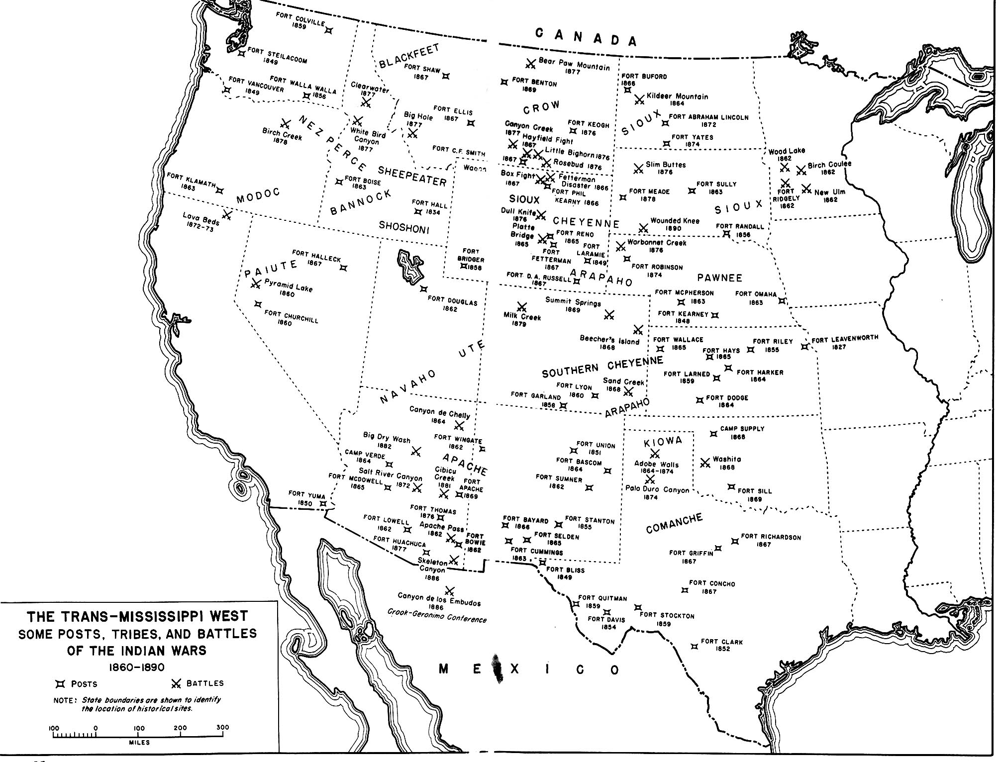
The Battle of Cibecue Creek was an engagement of the Apache Wars, fought in August 1881 between the United States and White Mountain Apaches in Arizona, at Cibecue Creek on the Fort Apache Indian Reservation. After an army expedition of scouts, U.S. Army soldiers 'arrested' a prominent Cibecue Apache medicine man named Nock-ay-det-klinne. The U.S. Army soldiers were taking Nock-ay-det-klinné back to the fort when they were ambushed by Apache warriors. During the conflict, the U.S. Army soldiers killed Nock-ay-det-klinné. Most of the 23 Apache scouts mutinied, in the largest such action of its kind in U.S. history. The soldiers retreated to Fort Apache. The following day, the White Mountain Apache mounted a counter-attack. The events sparked general unrest and led to White Mountain Apache warriors leaving the Fort Apache Indian Reservation to join forces with the Apache leader of the Bedonkohe band of Chiricahua Apache named Goyąąłé (Wise man), better known as Geronimo. ... [...More Info...] [...Related Items...] OR: [Wikipedia] [Google] [Baidu] |
Apache–Sitgreaves National Forests
The Apache–Sitgreaves National Forests is a United States National Forest which runs along the Mogollon Rim and the White Mountains in east-central Arizona and into the U.S. state of New Mexico. Formerly two forests, it is currently managed as one unit by USDA Forest Service from the Forest Supervisors Office in Springerville, Arizona. Apache–Sitgreaves has over 400 species of wildlife. With its high elevation and cool summer breezes it is a popular weekend destination from the hot desert for Phoenix, Arizona, residents. The forest is divided into 5 Ranger Districts (Clifton, Alpine, Springerville, Lakeside, and Black Mesa) that span almost from Clifton, Arizona in the east-central portion of Arizona to the eastern boundary of the Coconino National Forest in north-central Arizona. The Apache–Sitgreaves National Forest borders the western and northern borders of the Fort Apache Indian Reservation. It is located in parts of Greenlee, Apache, Navajo, and Coconino coun ... [...More Info...] [...Related Items...] OR: [Wikipedia] [Google] [Baidu] |
Salt River (Arizona)
The Salt River (Spanish language, Spanish: , O'odham language, O'odham [Pima]: , Yavapai language, Yavapai: or , Maricopa language: Va Shly'ay) is a river in Gila County, Arizona, Gila and Maricopa County, Arizona, Maricopa counties in Arizona, United States, that is the largest tributary of the Gila River. The river is about 200 miles (320 km) long.Calculated with Google Maps and Google Earth Its drainage basin covers about 13,700 square miles (35,000 km2). The longest of the Salt River's many tributaries is the 195-mile (314 km) Verde River. The Salt's headwaters tributaries, the Black River and East Fork, increase the river's total length to about 300 miles (480 km). The name Salt River comes from the river's course over large salt deposits shortly after the merging of the White and Black Rivers. Variant names According to the Geographic Names Information System, the Salt River has also been known as: * Assumption * Black River * Blau Fluss ... [...More Info...] [...Related Items...] OR: [Wikipedia] [Google] [Baidu] |
Bureau Of Indian Affairs
The Bureau of Indian Affairs (BIA), also known as Indian Affairs (IA), is a United States List of United States federal agencies, federal agency within the U.S. Department of the Interior, Department of the Interior. It is responsible for implementing Federal law (United States), federal laws and policies related to Native Americans in the United States, Native Americans and Alaska Natives, and administering and managing over of Indian reservation, reservations Trust law, held in trust by the Federal government of the United States, U.S. federal government for List of federally recognized tribes, indigenous tribes. It renders services to roughly 2 million indigenous Americans across 574 federally recognized tribes. The BIA is governed by a director and overseen by the assistant secretary for Indian affairs, who answers to the United States Secretary of the Interior, secretary of the interior. The BIA works with Tribal sovereignty in the United States, tribal governments to h ... [...More Info...] [...Related Items...] OR: [Wikipedia] [Google] [Baidu] |
Rivers Of Navajo County, Arizona
A river is a natural stream of fresh water that flows on land or inside caves towards another body of water at a lower elevation, such as an ocean, lake, or another river. A river may run dry before reaching the end of its course if it runs out of water, or only flow during certain seasons. Rivers are regulated by the water cycle, the processes by which water moves around the Earth. Water first enters rivers through precipitation, whether from rainfall, the runoff of water down a slope, the melting of glaciers or snow, or seepage from aquifers beneath the surface of the Earth. Rivers flow in channeled watercourses and merge in confluences to form drainage basins, or catchments, areas where surface water eventually flows to a common outlet. Rivers have a great effect on the landscape around them. They may regularly overflow their banks and flood the surrounding area, spreading nutrients to the surrounding area. Sediment or alluvium carried by rivers shapes the landscape aro ... [...More Info...] [...Related Items...] OR: [Wikipedia] [Google] [Baidu] |


