|
Chokmanovo
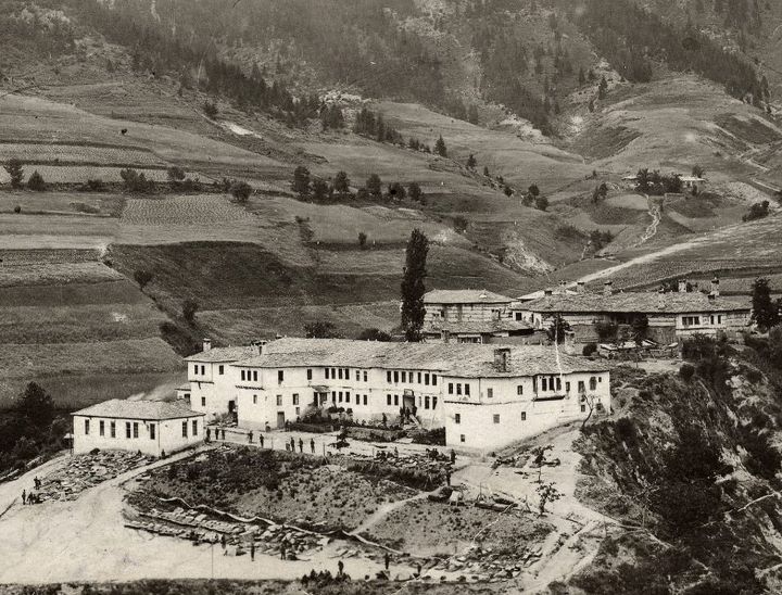
Chokmanovo () is a village in the municipality of Smolyan, in the Arda valley of the Rhodopi Mountain range. It is 11 km south of the town of Smolyan and 30 km from the ski resort of Pamporovo. The region is very sunny, and the village is near the top of a southern slope so it receives direct sun more than 300 days a year. It has 4 seasons, is snowy in winter, and is subject to spectacular thunderstorms in the late afternoons of summer. In antiquity, the Greeks regarded this as a fierce, uninhabitable area of rough terrain and intolerable weather. The Ottomans seemed to agree, Chokmanovo translates as "the untamable people". The herdsmen in the 20th century practiced an ancient pattern of pasturing. Large family associations moved their herds south to winter in the valleys near the Mediterranean and split into smaller herds to exploit summer pastures in the valleys of the Rhodopes. Chokmanovo was a summer area, and some of the oldest residents still remember walking t ... [...More Info...] [...Related Items...] OR: [Wikipedia] [Google] [Baidu] |
Smolyan
Smolyan () is a List of cities and towns in Bulgaria, town and ski resort in the south of Bulgaria near the border with Greece. It is the administrative and industrial centre of the Smolyan Province. The town is built along the narrow valley of the Cherna (Arda), Cherna ('black') and the Byala River, Byala ('white') river in the central Rhodope Mountains. It is located at the foot of the mountain's highest peak Golyam Perelik (2191 m). Popular ski resorts of Pamporovo and Chepelare lie in the vicinity. As of June 2022 the town has a population of 30 689 inhabitants. Name The name of the town comes from the local Slavic tribe of the Smolyani, the name of whom is probably cognate to the Slavic word ''smola'' ("resin"). History According to archaeological evidence, the area around Smolyan was first settled in the 2nd millennium BC, 2nd-1st millennium BC. In the Middle Ages it acquired its name from the Slavic peoples, Slavic tribe, the ''Smolyani'', who settled in the region i ... [...More Info...] [...Related Items...] OR: [Wikipedia] [Google] [Baidu] |
Rhodope Mountains
The Rhodopes (; , ; , ''Rodopi''; ) are a mountain range in Southeastern Europe, and the largest by area in Bulgaria, with over 83% of its area in the southern part of the country and the remainder in Greece. Golyam Perelik is its highest peak at . The mountain range gives its name to the terrestrial ecoregion Rodope montane mixed forests that belongs in the temperate broadleaf and mixed forests biome and the Palearctic realm. The region is particularly notable for its karst areas with their deep river gorges, large caves and specific sculptured forms, such as the Trigrad Gorge. A significant part of Bulgaria's hydropower resources are located in the western areas of the range. There are a number of hydro-cascades and dams used for electricity production, irrigation, and as tourist destinations. Name and mythology The name of the Rhodope Mountains is of Thracian origin. Rhod-ope (Род-oпа) is interpreted as the first name of a river, meaning "rusty/reddish river", wher ... [...More Info...] [...Related Items...] OR: [Wikipedia] [Google] [Baidu] |
Pamporovo
Pamporovo (, ''pronunciation'': /pam'porovo/) is a popular ski resort in Smolyan Province, southern Bulgaria. It is set amongst Norway spruce forests and is primarily visited during the winter for skiing and snowboarding. It is also a popular tourist place in summer. The hub of Pamporovo comprises a number of hotels and bars. It is a family-friendly resort and suited for complete beginners and intermediates. Location The resort is set in the southern Rhodope Mountains at an altitude of 1620 meters above sea level. The highest peak in the area, Snezhanka Peak (Bulgarian: Снежанка) at 1928 m, is several hundred meters above the resort and hosts Snezhanka Tower. Pamporovo is around 260 km away from Sofia, 85 km south of Plovdiv, 15 km north of Smolyan, and 10 km south of Chepelare. Skiing The resort has 55 km of ski-runs and 38 km of cross-country skiing tracks served by 18 lifts with a total capacity of 13,000 persons per hour. Seven sno ... [...More Info...] [...Related Items...] OR: [Wikipedia] [Google] [Baidu] |
Ottoman Empire
The Ottoman Empire (), also called the Turkish Empire, was an imperial realm that controlled much of Southeast Europe, West Asia, and North Africa from the 14th to early 20th centuries; it also controlled parts of southeastern Central Europe, between the early 16th and early 18th centuries. The empire emerged from a ''beylik'', or principality, founded in northwestern Anatolia in by the Turkoman tribal leader Osman I. His successors conquered much of Anatolia and expanded into the Balkans by the mid-14th century, transforming their petty kingdom into a transcontinental empire. The Ottomans ended the Byzantine Empire with the conquest of Constantinople in 1453 by Mehmed II. With its capital at Constantinople and control over a significant portion of the Mediterranean Basin, the Ottoman Empire was at the centre of interactions between the Middle East and Europe for six centuries. Ruling over so many peoples, the empire granted varying levels of autonomy to its many confe ... [...More Info...] [...Related Items...] OR: [Wikipedia] [Google] [Baidu] |


