|
Choctawhatchee National Forest
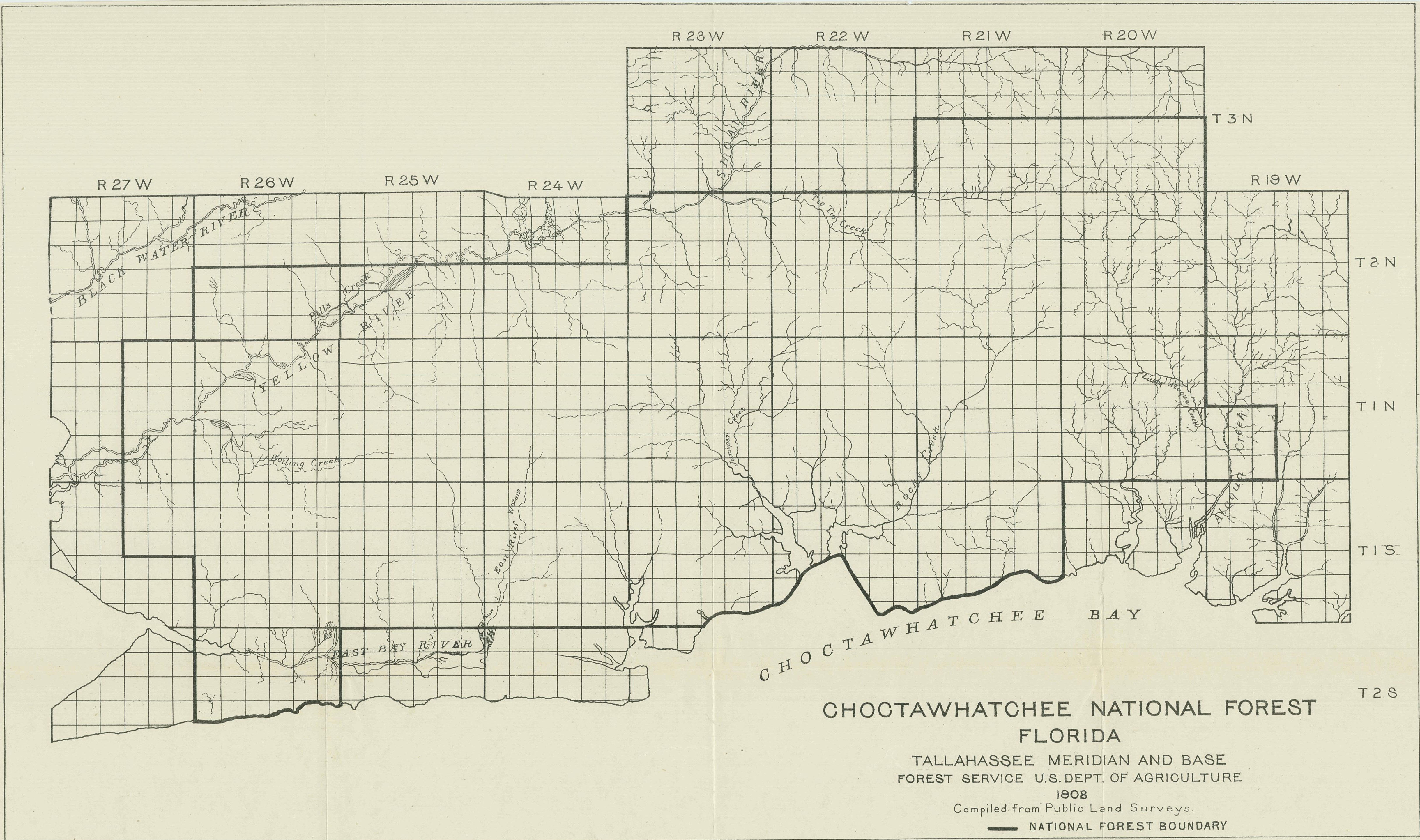
Choctawhatchee National Forest is a United States National Forest established by President Theodore Roosevelt on November 27, 1908. The supervisory headquarters was established at DeFuniak Springs and moved to Pensacola in September 1910. It remained there until 1936 when it was relocated to Tallahassee. The Choctawhatchee's two districts (Easy Bay- Camp Pinchot and Niceville) were separated by what is now State Road 85. National defense needs prompted Congress to transfer the national forest to the War Department just prior to World War II. On June 27, 1940, Congress transferred the 340,890 acres (1380 km²) of the Choctawhatchee from the Forest Service to the War Department (and subsequently to its successor's constituent United States Department of the Air Force) for military purposes. The law provided that the land might be restored to national forest status by proclamation or order of the President when it was no longer needed for military purposes. It has been home ... [...More Info...] [...Related Items...] OR: [Wikipedia] [Google] [Baidu] |
Florida
Florida is a state located in the Southeastern region of the United States. Florida is bordered to the west by the Gulf of Mexico, to the northwest by Alabama, to the north by Georgia, to the east by the Bahamas and Atlantic Ocean, and to the south by the Straits of Florida and Cuba; it is the only state that borders both the Gulf of Mexico and the Atlantic Ocean. Spanning , Florida ranks 22nd in area among the 50 states, and with a population of over 21 million, it is the third-most populous. The state capital is Tallahassee, and the most populous city is Jacksonville. The Miami metropolitan area, with a population of almost 6.2 million, is the most populous urban area in Florida and the ninth-most populous in the United States; other urban conurbations with over one million people are Tampa Bay, Orlando, and Jacksonville. Various Native American groups have inhabited Florida for at least 14,000 years. In 1513, Spanish explorer Juan Ponce de León became th ... [...More Info...] [...Related Items...] OR: [Wikipedia] [Google] [Baidu] |
United States Department Of The Air Force
The United States Department of the Air Force (DAF) is one of the three military departments within the Department of Defense of the United States of America. The Department of the Air Force was formed on September 18, 1947, per the National Security Act of 1947 (codified into Title 10 of the United States Code) and it is the military department within which the United States Air Force and the United States Space Force are organized. The Department of the Air Force is headed by the Secretary of the Air Force (SAF/OS), a civilian, who has the authority to conduct all of its affairs, subject to the authority, direction and control of the Secretary of Defense. The Secretary of the Air Force's principal deputy is the Under Secretary of the Air Force (SAF/US). Their senior staff assistants in the Office of the Secretary of the Air Force are five Assistant Secretaries for Acquisition, Financial Management & Comptroller, Installations, Environment & Logistics, Manpower & Reserve Af ... [...More Info...] [...Related Items...] OR: [Wikipedia] [Google] [Baidu] |
Protected Areas Of Walton County, Florida
Protection is any measure taken to guard a thing against damage caused by outside forces. Protection can be provided to physical objects, including organisms, to systems, and to intangible things like civil and political rights. Although the mechanisms for providing protection vary widely, the basic meaning of the term remains the same. This is illustrated by an explanation found in a manual on electrical wiring: Some kind of protection is a characteristic of all life, as living things have evolved at least some protective mechanisms to counter damaging environmental phenomena, such as ultraviolet light. Biological membranes such as bark on trees and skin on animals offer protection from various threats, with skin playing a key role in protecting organisms against pathogens and excessive water loss. Additional structures like scales and hair offer further protection from the elements and from predators, with some animals having features such as spines or camouflage servin ... [...More Info...] [...Related Items...] OR: [Wikipedia] [Google] [Baidu] |
National Forests Of Florida
National may refer to: Common uses * Nation or country ** Nationality – a ''national'' is a person who is subject to a nation, regardless of whether the person has full rights as a citizen Places in the United States * National, Maryland, census-designated place * National, Nevada, ghost town * National, Utah, ghost town * National, West Virginia, unincorporated community Commerce * National (brand), a brand name of electronic goods from Panasonic * National Benzole (or simply known as National), former petrol station chain in the UK, merged with BP * National Car Rental, an American rental car company * National Energy Systems, a former name of Eco Marine Power * National Entertainment Commission, a former name of the Media Rating Council * National Motor Vehicle Company, Indianapolis, Indiana, USA 1900-1924 * National Supermarkets, a defunct American grocery store chain * National String Instrument Corporation, a guitar company formed to manufacture the first resonator gui ... [...More Info...] [...Related Items...] OR: [Wikipedia] [Google] [Baidu] |
Osceola National Forest
Osceola National Forest is a National Forest located in northeast Florida. Osceola National Forest was created by President Herbert Hoover's proclamation on July 10, 1931. It is named in honor of the noted Seminole warrior, Osceola. The forest is made up of approximately of pine flatwoods and cypress-hardwood swamps in northeastern Florida, and is about west of Jacksonville. It is located in parts of Columbia, Baker, Bradford, and Hamilton counties. The forest administration headquarters are in Tallahassee, as are all three National Forests in Florida. Local ranger district offices are located in Olustee. There is one officially designated wilderness area in the forest, the Big Gum Swamp Wilderness. Geography and ecology Within the forest is the Osceola Research Natural Area, designated a National Natural Landmark in December 1974. Osceola National Forest is home to many birds as well as mammalian and reptilian species, including the alligator, eastern indigo snake, ... [...More Info...] [...Related Items...] OR: [Wikipedia] [Google] [Baidu] |
Ocala National Forest
The Ocala National Forest ls the second largest nationally protected forest in the U.S. State of Florida. It covers of northern Florida. It is located three miles (5 km) east of Ocala and southeast of Gainesville. The Ocala National Forest, established in 1908, is the oldest national forest east of the Mississippi River and the southernmost national forest in the continental U.S. The word ''Ocala'' is thought to be a derivative of a Timucuan term meaning "fair land" or "big hammock". The forest is headquartered in Tallahassee, as are all three National Forests in Florida, but there are local ranger district offices located in Silver Springs and Umatilla. Geography and ecology The Ocala National Forest lies between the Ocklawaha and St. Johns rivers in Central Florida. In descending order of land area, it is located in parts of Marion, Lake, and Putnam counties. The Ocala National Forest is in the southeastern conifer forests and the Florida sand pine scrub ... [...More Info...] [...Related Items...] OR: [Wikipedia] [Google] [Baidu] |
Camp Pinchot Historic District
The Camp Pinchot Historic District is a United States, U.S. Historic district (United States), historic district (designated as such on 22 October 1998), located approximately north of Fort Walton Beach, Florida, Fort Walton Beach, Florida. The district is on Eglin Air Force Base, roughly along the west bank of Garnier's Bayou. It contains 10 historic buildings. See also * Choctawhatchee National Forest References External links Okaloosa County listingsaNational Register of Historic Places * at Geography of Okaloosa County, Florida Historic districts on the National Register of Historic Places in Florida National Register of Historic Places in Okaloosa County, Florida 1998 establishments in Florida {{OkaloosaCountyFL-NRHP-stub ... [...More Info...] [...Related Items...] OR: [Wikipedia] [Google] [Baidu] |
Apalachicola National Forest
The Apalachicola National Forest is the largest U.S. National Forest in the state of Florida. It encompasses and is the only national forest located in the Florida Panhandle. The National Forest provides water and land-based outdoors activities such as off-road biking, hiking, swimming, boating, hunting, fishing, horse-back riding, and off-road ATV usage. Apalachicola National Forest contains two Wilderness Areas: Bradwell Bay Wilderness and Mud Swamp/New River Wilderness. There are also several special purpose areas: Camel Lake Recreation Area, Fort Gadsden Historical Site, Leon Sinks Geological Area, Silver Lake Recreation Area, Trout Pond Recreation Area, and Wright Lake Recreation Area. In descending order of forest land area it is located in parts of Liberty, Wakulla, Leon, and Franklin countiesThe forest is headquartered in Tallahassee, Florida, Tallahassee, as are all three National Forests in Florida, but there are local forest ranger district offices located in B ... [...More Info...] [...Related Items...] OR: [Wikipedia] [Google] [Baidu] |
Santa Rosa County, Florida
Santa Rosa County is a county located in the northwestern portion of the U.S. state of Florida. As of 2020, the population is 188,000. The county seat is Milton, which lies in the geographic center of the county. Other major communities within Santa Rosa County are Navarre, Pace, and Gulf Breeze. Navarre is the most populated community with a population of approximately 45,000 residents. Santa Rosa County is included in the Pensacola Metropolitan Statistical Area, which also includes Escambia County. History Santa Rosa County was created in 1842, when it was divided from Escambia County. It was named after the barrier island along its southern coast, which in turn had been named for the Roman Catholic saint, Rosa de Viterbo. Santa Rosa County repealed its prohibition on alcohol in 2005. Santa Rosa County has seen unprecedented growth in population, specifically in the communities of Navarre, Pace, and Gulf Breeze. The county is a quickly growing tourist destination beca ... [...More Info...] [...Related Items...] OR: [Wikipedia] [Google] [Baidu] |
Walton County, Florida
Walton County is located on the Emerald Coast in the northwestern part of the U.S. state of Florida, with its southern border on the Gulf of Mexico. As of the 2020 census, the population was 75,305. Its county seat is DeFuniak Springs. The county is home to the highest natural point in Florida: Britton Hill, at . Walton County is included in the Crestview–Fort Walton Beach–Destin Metropolitan Statistical Area. History Walton County was organized by European Americans in 1824. It was named for Colonel George Walton Jr., secretary of the Florida Territory from 1821 to 1826. Walton, the son of George Walton, a signer of the Declaration of Independence, was born 15 August 1786 in Augusta, Georgia, and died 20 March 1859 in Petersburg, Virginia. Between 1763 and 1783 the territory that has since become Walton County was part of the colony of British West Florida. During this time British settlers permanently settled in the area, becoming the first English-speaking people ... [...More Info...] [...Related Items...] OR: [Wikipedia] [Google] [Baidu] |


